Jasper County, South Carolina

Last updated

Jasper County
Jasper County Court House.jpg
Jasper County Flag.gif
Jasper County Seal.png
Map of South Carolina highlighting Jasper County.svg
Location within the U.S. state of South Carolina
South Carolina in United States.svg
South Carolina's location within the U.S.
Coordinates: 32°26′N81°01′W / 32.43°N 81.02°W / 32.43; -81.02
CountryFlag of the United States.svg United States
StateFlag of South Carolina.svg  South Carolina
Founded1912
Named for William Jasper
Seat Ridgeland
Largest community Hardeeville
Area
  Total701.58 sq mi (1,817.1 km2)
  Land655.16 sq mi (1,696.9 km2)
  Water46.42 sq mi (120.2 km2)  6.62%
Population
 (2020)
  Total28,791
  Estimate 
(2023)
33,544
  Density43.94/sq mi (16.97/km2)
Time zone UTC−5 (Eastern)
  Summer (DST) UTC−4 (EDT)
Congressional districts 1st, 6th
Website www.jaspercountysc.gov

Jasper County is the southernmost county in the U.S. state of South Carolina. As of the 2020 census, the population was 28,791. [1] Its county seat is Ridgeland and its largest community is Hardeeville. [2] The county was formed in 1912 from portions of Hampton County and Beaufort County.

Contents

Jasper County is included in the Hilton Head Island-Bluffton-Port Royal, SC Metropolitan Statistical Area. It is located in the Lowcountry region of the state.

History

The county was founded in 1912 and was named after William Jasper. The county seat is Ridgeland while the largest community is Hardeeville. The county is also in the Hilton Head Island-Bluffton-Port Royal, SC Metropolitan Statistical Area.

For several decades, in contrast to neighboring Beaufort County, Jasper was one of the poorest counties in the state. Recent development from 2000 onwards has given the county new residents, expanded business opportunities, and a wealthier tax base.

Geography

Jasper County, South Carolina
Interactive map of Jasper County

According to the U.S. Census Bureau, the county has a total area of 701.58 square miles (1,817.1 km2), of which 655.16 square miles (1,696.9 km2) is land and 46.42 square miles (120.2 km2) (6.62%) is water. [3]

National protected areas

State and local protected areas/sites

Major water bodies

Adjacent counties

Major highways

Demographics

Historical population
CensusPop.Note
1920 9,868
1930 9,9881.2%
1940 11,01110.2%
1950 10,995−0.1%
1960 12,23711.3%
1970 11,885−2.9%
1980 14,50422.0%
1990 15,4876.8%
2000 20,67833.5%
2010 24,77719.8%
2020 28,79116.2%
2023 (est.)33,544 [1] 16.5%
U.S. Decennial Census [7]
1790–1960 [8] 1900–1990 [9]
1990–2000 [10] 2010 [11] 2020 [12]

2020 census

Jasper County, South Carolina – Racial and ethnic composition
Note: the U.S. census treats Hispanic/Latino as an ethnic category. This table excludes Latinos from the racial categories and assigns them to a separate category. Hispanics/Latinos may be of any race.
Race / Ethnicity (NH = Non-Hispanic)Pop 2000 [13] Pop 2010 [11] Pop 2020 [12] % 2000% 2010% 2020
White alone (NH)8,3749,26313,05640.50%37.39%45.35%
Black or African American alone (NH)10,85211,3039,55952.48%45.62%33.20%
Native American or Alaska Native alone (NH)6449590.31%0.20%0.20%
Asian alone (NH)891691870.43%0.68%0.65%
Pacific Islander alone (NH)95230.04%0.02%0.08%
Other race alone (NH)13211080.06%0.08%0.38%
Mixed race or Multiracial (NH)872157200.42%0.87%2.50%
Hispanic or Latino (any race)1,1903,7525,0795.75%15.14%17.64%
Total20,67824,77728,791100.00%100.00%100.00%

As of the 2020 census, there were 28,791 people, 10,269 households, and 7,298 families residing in the county.

2010 census

At the 2010 census, there were 24,777 people, 8,517 households, and 5,944 families living in the county. [14] [15] The population density was 37.8 inhabitants per square mile (14.6 inhabitants/km2). There were 10,299 housing units at an average density of 15.7 units per square mile (6.1 units/km2). [16] The racial makeup of the county was 46.0% black or African American, 43.0% white, 0.7% Asian, 0.5% American Indian, 0.1% Pacific islander, 8.3% from other races, and 1.4% from two or more races. Those of Hispanic or Latino origin made up 15.1% of the population. [14] In terms of ancestry, 7.1% were Irish, and 2.5% were American. [17]

Of the 8,517 households, 36.9% had children under the age of 18 living with them, 44.2% were married couples living together, 18.6% had a female householder with no husband present, 30.2% were non-families, and 24.8% of all households were made up of individuals. The average household size was 2.73 and the average family size was 3.23. The median age was 34.6 years. [14]

The median income for a household in the county was $37,393 and the median income for a family was $45,800. Males had a median income of $31,999 versus $24,859 for females. The per capita income for the county was $17,997. About 14.2% of families and 21.5% of the population were below the poverty line, including 32.2% of those under age 18 and 14.5% of those age 65 or over. [18]

2000 census

At the 2000 census, [19] there were 20,678 people, 7,042 households, and 5,091 families living in the county. The population density was 32 people per square mile (12 people/km2). There were 7,928 housing units at an average density of 12 units per square mile (4.6 units/km2). The racial makeup of the county was 52.69% Black or African American, 42.39% White, 0.37% Native American, 0.44% Asian, 0.05% Pacific Islander, 3.39% from other races, and 0.67% from two or more races. 5.75% of the population were Hispanic or Latino of any race.

There were 7,042 households, out of which 34.5% had children under the age of 18 living with them, 48.1% were married couples living together, 18.2% had a female householder with no husband present, and 27.7% were non-families. 23.2% of all households were made up of individuals, and 8.8% had someone living alone who was 65 years of age or older. The average household size was 2.75 and the average family size was 3.22.

In the county, the population was spread out, with 26.8% under the age of 18, 10.3% from 18 to 24, 30.7% from 25 to 44, 21.2% from 45 to 64, and 11.0% who were 65 years of age or older. The median age was 34 years. For every 100 females, there were 111.0 males. For every 100 females age 18 and over, there were 111.3 males.

The median income for a household in the county was $30,727, and the median income for a family was $36,793. Males had a median income of $29,407 versus $21,055 for females. The per capita income for the county was $14,161. About 15.4% of families and 20.7% of the population were below the poverty line, including 26.3% of those under age 18 and 21.4% of those age 65 or over.

Law and government

Jasper County is governed by a five-member partisan county council, who are elected in staggered four year terms. The council appoints a county administrator who is tasked with running the day-to-day operations of the county, with the exception of the Sheriff's Office.

Mary Gordon Ellis, the first woman elected to the South Carolina legislature, represented Jasper County in the state senate for one term, from 1928 to 1932, after having served as state superintendent of schools. [20]

Politics

United States presidential election results for Jasper County, South Carolina [21]
Year Republican Democratic Third party
No.%No.%No.%
2020 7,07849.17%7,18549.92%1310.91%
2016 5,18745.39%5,95652.12%2842.49%
2012 4,16941.60%5,75757.45%950.95%
2008 3,36538.01%5,38960.87%1001.13%
2004 2,93342.84%3,84056.09%731.07%
2000 2,41437.32%3,64656.36%4096.32%
1996 2,02431.29%4,05362.66%3916.05%
1992 1,72529.93%3,45359.92%58510.15%
1988 2,00440.66%2,89458.71%310.63%
1984 3,10245.09%3,75354.56%240.35%
1980 1,61732.54%3,31266.65%400.80%
1976 1,22129.49%2,90370.12%160.39%
1972 1,65057.21%1,20341.71%311.07%
1968 63320.31%1,40244.99%1,08134.69%
1964 1,59361.39%1,00238.61%00.00%
1960 77951.93%72148.07%00.00%
1956 40331.71%21016.52%65851.77%
1952 80055.71%63644.29%00.00%
1948 313.49%14115.90%71580.61%
1944 183.96%23050.66%20645.37%
1940 418.93%41891.07%00.00%
1936 40.88%45299.12%00.00%
1932 112.68%39997.32%00.00%
1928 54.67%10295.33%00.00%
1924 00.00%8969.53%3930.47%
1920 00.00%219100.00%00.00%
1916 00.00%243100.00%00.00%
1912 00.00%198100.00%00.00%

Communities

City

Town

Unincorporated communities

See also

Related Research Articles

<span class="mw-page-title-main">Walker County, Alabama</span> County in Alabama, United States

Walker County is a county located in the central portion of the U.S. state of Alabama. As of the 2020 census, the population was 65,342. Its county seat is Jasper. Its name is in honor of John Williams Walker, the first U.S. senator elected from Alabama.

<span class="mw-page-title-main">Newberry County, South Carolina</span> County in South Carolina, United States

Newberry County is a county located in the U.S. state of South Carolina. As of the 2020 census, its population was 37,719. Its county seat is Newberry. The name is of unknown origin, although one theory suggests that it was named by Quaker settlers in honor of their home of Newberry, a suburb of London in the United Kingdom.

<span class="mw-page-title-main">McCormick County, South Carolina</span> County in South Carolina, United States

McCormick County is a county located in the U.S. state of South Carolina. As of the 2020 census, its population was 9,526, making it the second-least populous county in South Carolina. Its county seat is McCormick. The county was formed in 1916 from parts of Edgefield, Abbeville, and Greenwood counties.

<span class="mw-page-title-main">Marion County, South Carolina</span> County in South Carolina, United States

Marion County is a county located in the coastal plain of the U.S. state of South Carolina. As of the 2020 census, its population was 29,183. Its county seat is Marion. It is a majority-minority county.

<span class="mw-page-title-main">Lee County, South Carolina</span> County in South Carolina, United States

Lee County is a county located in the U.S. state of South Carolina. As of the 2020 census, its population was 16,531, making it the fifth-least populous county in South Carolina. Its county seat is Bishopville.

<span class="mw-page-title-main">Hampton County, South Carolina</span> County in South Carolina, United States

Hampton County is a rural county located in the U.S. state of South Carolina. As of the 2020 census, the population was 18,561. Its county seat is Hampton. It was named for Confederate Civil War general Wade Hampton, who in the late 1870s, with the ending of Reconstruction, was elected as governor of South Carolina.

<span class="mw-page-title-main">Darlington County, South Carolina</span> County in South Carolina, United States

Darlington County is a county in the U.S. state of South Carolina. As of the 2020 census, its population was 62,905. Its county seat is Darlington. Hartsville is the largest community in the county. Darlington County is home to the Darlington Raceway, which hosts the annual NASCAR Southern 500. Darlington County is also home to Coker College in Hartsville. Darlington County was named by an act in March 1785.

<span class="mw-page-title-main">Colleton County, South Carolina</span> County in South Carolina, United States

Colleton County is in the Lowcountry region of the U.S. state of South Carolina. As of the 2020 census, the population was 38,604. Its county seat is Walterboro. The county is named after Sir John Colleton, 1st Baronet, one of the eight Lords Proprietor of the Province of Carolina. After two previous incarnations, the current Colleton County was created in 1800.

<span class="mw-page-title-main">Chester County, South Carolina</span> County in South Carolina, United States

Chester County is a county located in the U.S. state of South Carolina. As of the 2020 census, its population was 32,294. Its county seat is Chester.

<span class="mw-page-title-main">Berkeley County, South Carolina</span> County in South Carolina, United States

Berkeley County is a county in the U.S. state of South Carolina. As of the 2020 census, its population was 229,861. Its county seat is Moncks Corner, and the largest community is Goose Creek. After two previous incarnations of Berkeley County, the current county was created in 1882. Berkeley County is included in the Charleston-North Charleston, SC Metropolitan Statistical Area.

<span class="mw-page-title-main">Beaufort County, South Carolina</span> County in South Carolina, United States

Beaufort County is a county in the U.S. state of South Carolina. As of the 2020 census, its population was 187,117. Its county seat is Beaufort and its largest community is Hilton Head Island.

<span class="mw-page-title-main">Ridgeland, Mississippi</span> City in Mississippi, United States

Ridgeland is a city in Madison County, Mississippi, United States. The population was 24,340 at the 2020 census. It is part of the Jackson metropolitan area.

<span class="mw-page-title-main">Allendale, South Carolina</span> Town in South Carolina, United States

Allendale is a town in and the county seat of Allendale County, South Carolina, United States. The population was 3,482 at the 2010 census, a decline from 4,052 in 2000.

<span class="mw-page-title-main">Furman, South Carolina</span> Town in South Carolina, United States

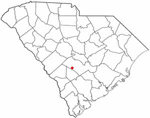
Furman is a town in Hampton County, South Carolina, United States. The population was 224 at the 2020 census, down from 239 at the 2010 census. It is not to be confused with Furman University, which is in Greenville, South Carolina.

<span class="mw-page-title-main">Hardeeville, South Carolina</span> City in South Carolina, United States

Hardeeville is a city in Jasper and Beaufort counties in the U.S. state of South Carolina. The population was 7,473 as of the 2020 census, an increase of over 150% since 2010. Hardeeville is included within the Hilton Head Island–Bluffton metropolitan area.

<span class="mw-page-title-main">Ridgeland, South Carolina</span> Town in South Carolina, United States

Ridgeland is a town in Jasper and Beaufort counties, South Carolina, United States. The population was 3,749 at the 2020 census, a 7.1% decrease from 2010. It has been the county seat of Jasper County since the county's formation in 1912. As defined by the U.S. Census Bureau, Ridgeland is included within the Hilton Head Island–Bluffton metropolitan area.

<span class="mw-page-title-main">Cope, South Carolina</span> Town in South Carolina, United States

Cope is a town in Orangeburg County, South Carolina, United States. The population was 65 at the 2020 census, a decline from 80 in 2010.

<span class="mw-page-title-main">Woodford, South Carolina</span> Town in South Carolina, United States

Woodford is a town in Orangeburg County, South Carolina, United States. The population was 185 at the 2010 census.

<span class="mw-page-title-main">Saxon, South Carolina</span> CDP in South Carolina, United States

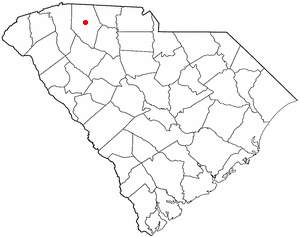
Saxon is a census-designated place (CDP) in Spartanburg County, South Carolina, United States. The population was 3,424 at the 2010 census.

<span class="mw-page-title-main">Hilton Head Island–Bluffton metropolitan area</span> Metropolitan Statistical Area in South Carolina, United States

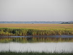
The Hilton Head Island metropolitan area, officially the Hilton Head Island–Bluffton–Port Royal, SC Metropolitan Statistical Area as defined by the United States Census Bureau, is a metropolitan statistical area consisting of the two southernmost counties in the Lowcountry region of South Carolina, centered on the resort town of Hilton Head Island. As of the 2020 census, the MSA had a population of 215,908. Prior to March 2013, the region was considered a micropolitan statistical area.

References

  1. 1 2 "QuickFacts: Jasper County, South Carolina". United States Census Bureau. Retrieved March 22, 2024.
  2. "Find a County". National Association of Counties. Archived from the original on May 31, 2011. Retrieved June 7, 2011.
  3. "2020 County Gazetteer Files – South Carolina". United States Census Bureau. August 23, 2022. Retrieved September 10, 2023.
  4. 1 2 "SCDNR Public Lands". www2.dnr.sc.gov. Retrieved April 1, 2023.
  5. Pinckney, Carmen (March 17, 2020). "Savannah National Wildlife Refuge Hiking Trails". South Carolina Lowcountry. Retrieved July 12, 2023.
  6. Roosevelt, Franklin D. (April 10, 1939). "Proclamation 2329—Closed Area Under the Migratory Bird Treaty Act, Georgia and South Carolina". The American Presidency Project. Retrieved July 12, 2023.
  7. "U.S. Decennial Census". United States Census Bureau. Retrieved March 18, 2015.
  8. "Historical Census Browser". University of Virginia Library. Retrieved March 18, 2015.
  9. Forstall, Richard L., ed. (March 27, 1995). "Population of Counties by Decennial Census: 1900 to 1990". United States Census Bureau. Retrieved March 18, 2015.
  10. "Census 2000 PHC-T-4. Ranking Tables for Counties: 1990 and 2000" (PDF). United States Census Bureau. April 2, 2001. Archived (PDF) from the original on October 9, 2022. Retrieved March 18, 2015.
  11. 1 2 "P2: Hispanic or Latino, and Not Hispanic or Latino by Race – 2010: DEC Redistricting Data (PL 94-171) – Jasper County, South Carolina". United States Census Bureau.
  12. 1 2 "P2: Hispanic or Latino, and Not Hispanic or Latino by Race – 2020: DEC Redistricting Data (PL 94-171) – Jasper County, South Carolina". United States Census Bureau.
  13. "P004 HISPANIC OR LATINO, AND NOT HISPANIC OR LATINO BY RACE – 2000: DEC Summary File 1 – Jasper County, South Carolina". United States Census Bureau.
  14. 1 2 3 "DP-1 Profile of General Population and Housing Characteristics: 2010 Demographic Profile Data". United States Census Bureau. Archived from the original on February 13, 2020. Retrieved March 11, 2016.
  15. "State & County QuickFacts". United States Census Bureau. Archived from the original on June 6, 2011. Retrieved October 1, 2014.
  16. "Population, Housing Units, Area, and Density: 2010 - County". United States Census Bureau. Archived from the original on February 13, 2020. Retrieved March 11, 2016.
  17. "DP02 SELECTED SOCIAL CHARACTERISTICS IN THE UNITED STATES – 2006-2010 American Community Survey 5-Year Estimates". United States Census Bureau. Archived from the original on February 13, 2020. Retrieved March 11, 2016.
  18. "DP03 SELECTED ECONOMIC CHARACTERISTICS – 2006-2010 American Community Survey 5-Year Estimates". United States Census Bureau. Archived from the original on February 13, 2020. Retrieved March 11, 2016.
  19. "U.S. Census website". United States Census Bureau . Retrieved May 14, 2011.
  20. "Women Wielding Power-South Carolina". nwhm.org. Archived from the original on September 6, 2015. Retrieved September 10, 2015.
  21. Leip, David. "Dave Leip's Atlas of U.S. Presidential Elections". uselectionatlas.org. Retrieved March 13, 2018.