ACE Basin

Last updated
Pine Island, ACE Basin National Estuarine Research Reserve Pine Island, ACE Basin National Estuarine Research Reserve.jpg
Pine Island, ACE Basin National Estuarine Research Reserve

The Ashepoo, Combahee and Edisto Basin (abbreviated as ACE Basin, spoken as ace basin) is one of the largest undeveloped estuaries along the Atlantic Coast of the United States. Located primarily in Colleton, Charleston, and Beaufort counties in South Carolina, the Ashepoo, Combahee and South Edisto rivers combine into the larger St. Helena Sound and drain a significant portion of the Lowcountry region. The 350,000 acres (1,400 km2) area is known for its natural environment and the preservation of its marshes, wetlands, hardwood forests, and riverine systems and the fauna that occupy the area.

Contents

A sizable portion of the ACE Basin has been protected via a public-private partnership with contributing properties. A collaboration of federal, state, local, and private efforts have led to the preservation of 250,000 acres of land, with stakeholders controlling various interests. The umbrella organization for these efforts is the ACE Basin Task Force.

History

Historically, the area was primarily agricultural, dominated by the plantation system. After the Civil War, only three plantation homes survived in the area, and much of the land became fertile ground for hunting and outdoor enthusiasts.

Development pressures emerged in the 1970s and 1980s, prompting concerned citizens to petition local, state, and federal authorities to assist with preserving the basin. In 1988, a group of concerned citizens and advocacy groups formed the ACE Basin Task Force which further formalized the cause for preservation and conservation. What emerged from these efforts became the ACE Basin Project, comprising the U.S. Fish and Wildlife Service (USFWS), the South Carolina Department of Natural Resources (SCDNR), The Nature Conservancy, Ducks Unlimited, and other private groups and companies to continue to collaborate on this endeavor. [1]

Among the more famous individuals that have contributed to land conservation efforts include Ted Turner and the descendants of the RR Donnelley estate, which set up a foundation to support conservation efforts in the ACE Basin and throughout the Lowcountry. [2] During his tenure in office, South Carolina's U.S. Senator Fritz Hollings procured $53.8 million for conservation efforts in the ACE Basin. [3]

The task force celebrated 30 years of conservation efforts in December 2019. [4] In November 2014, National Geographic had a featured article celebrating 25 years of conservation efforts in the ACE Basin. [5]

Geography

The basin is located along the southern half of South Carolina's Atlantic coastline, situated between Charleston and Beaufort. The basin's name comes after the three major rivers that drain the area: the Ashepoo, the Combahee, and the Edisto. These rivers drain primarily into the St. Helena Sound, which drains into the Atlantic Ocean between Hunting Island and Edisto Island.

The basin's boundaries are roughly defined to include all of Edisto Island and running northwesterly towards Walterboro, then heading southwest towards Garden's Corner and Yemassee before heading back towards the ocean, including all of the St. Helena Sound and Hunting Island State Park. Of the 350,000 acres (1,400 km2) that are comprised by this area, nearly half are officially monitored by the National Estuarine Research Reserve system.

Protected areas

Listed below is a partial list of protected areas in the ACE Basin, not including private conservation easements:

The ACE Basin National Estuarine Research Reserve was formed in 1992 and is a partnership between the National Oceanic and Atmospheric Administration (NOAA) and the South Carolina Department of Natural Resources (SCDNR). The reserve itself consists of over 140,000 acres (570 km2) which consists of a mixture of upland and lowland that is publicly protected or privately owned. In essence, it is an overlay area and is not in direct control or ownership of any specific land area. NERR staff monitors indicators such as flora/fauna livelihood and water quality, provides educational and scientific support to visitors and researchers and offers training programs for conservationists and other stakeholders.

The Ernest F. Hollings ACE Basin National Wildlife Refuge is a federally protected, 11,815 acres (48 km2) national wildlife refuge made up of two units: the Edisto River unit (7,200 acres (29 km2)) and the Combahee River unit (4,564 acres (18.5 km2)). The refuge operates an office out of the Grove Plantation House which receives visitors and hosts various educational and scientific programs and research projects.

The Bear Island Wildlife Management Area is a 12,021 acres (49 km2) reserve that is managed by SCDNR. The area is open to the public from early February to late October and is a popular spot for hiking, biking, birding, fishing, and hunting. A wide variety of waterfowl species inhabit the area. The area shuts down periodically for special hunts.

The Donnelley Wildlife Management Area is an 8,041 acres (33 km2) reserve that is managed by SCDNR. The area is open to the public year-round, however hunting season from early November to early February restricts access for hikers, bikers, horseback riders, and other non-hunting activities. The area is named after the Donnelley family, which was instrumental in the ACE Basin Project's history and features a wide mix of landscapes and fauna.

The St. Helena Sound Heritage Preserve is a 10,301 acres (42 km2) area managed by SCDNR that consists of several small upland and lowland islands located along the northern shore of the St. Helena Sound. These islands are far-reaching and offer archery hunting for deer (November only) and primitive camping opportunities. Otter Island in particular has further protections due to its unique and rare plant species and its historic status.

Additional contributing properties include:

Access

The principal road through the ACE Basin is U.S. Highway 17 (the ACE Basin Parkway), which skirts the northern reaches of the protected areas and providing transportation connection between the areas clustered around Charleston, Beaufort and Savannah. Small hamlets do exist in the ACE Basin, including the communities of Bennetts Point, Green Pond, Jacksonboro, Wiggins and Willtown Bluff. The largest community in close proximity is Walterboro, accessible via S.C. Highway 303 and S.C. Highway 64.

There are 23 boat landings in the 350,000 acres (1,400 km2) region, mostly maintained by state or county government agencies. Four of these landings are canoe or kayak launch only.

Related Research Articles

<span class="mw-page-title-main">Colleton County, South Carolina</span> County in South Carolina, United States

Colleton County is in the Lowcountry region of the U.S. state of South Carolina. As of the 2020 census, the population was 38,604. Its county seat is Walterboro. The county is named after Sir John Colleton, 1st Baronet, one of the eight Lords Proprietor of the Province of Carolina. After two previous incarnations, the current Colleton County was created in 1800.

<span class="mw-page-title-main">Beaufort County, South Carolina</span> County in South Carolina, United States

Beaufort County is a county in the U.S. state of South Carolina. As of the 2020 census, its population was 187,117. Its county seat is Beaufort and its largest town is Hilton Head Island.

<span class="mw-page-title-main">Hunting Island State Park</span> Barrier island and state park in South Carolina, United States

Hunting Island is a 5,000-acre (20 km2) secluded semitropical barrier island located 15 miles (24 km) east of Beaufort, South Carolina, United States in between Harbor Island and Fripp Island. Since 1935, it has been classified as a state park. It is the most-visited state park facility in South Carolina and is a part of the ACE Basin estuarine reserve area. Known for its natural environment, the island remains one of the few remaining undeveloped Sea Islands in the Lowcountry. The park is known for its 19th century lighthouse which bears its name. The park's beach has been featured in several travel publications and was listed in 2013 as a Top 25 beach in the United States by TripAdvisor.

<span class="mw-page-title-main">South Carolina Lowcountry</span> Geographic and cultural region located along South Carolinas coast

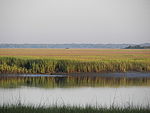
The Lowcountry is a geographic and cultural region along South Carolina's coast, including the Sea Islands. The region includes significant salt marshes and other coastal waterways, making it an important source of biodiversity in South Carolina.

<span class="mw-page-title-main">Edisto River</span> River in South Carolina, United States

The Edisto River is one of the longest free-flowing blackwater rivers in North America, flowing over 250 meandering miles from its sources in Saluda and Edgefield counties, to its Atlantic Ocean mouth at Edisto Beach, South Carolina. It rises in two main tributaries from springs under the Sandhills region of West Central South Carolina, just to the south of the Piedmont Fall Line. It is the longest and largest river system completely contained by the borders of South Carolina. Its name comes from the Edisto subtribe of the Cusabo Indians.

<span class="mw-page-title-main">Combahee River</span> River in South Carolina, United States of America

The Combahee River is a short blackwater river in the southern Lowcountry region of South Carolina formed at the confluence of the Salkehatchie and Little Salkehatchie rivers near the Islandton community of Colleton County, South Carolina. Part of its lower drainage basin combines with the Ashepoo River and the Edisto River to form the ACE Basin. The Combahee empties into Saint Helena Sound near Beaufort, which in turn empties into the Atlantic Ocean.

The Savannah National Wildlife Refuge is a 31,551-acre (12,768 ha) National Wildlife Refuge located in Chatham and Effingham counties in Georgia and Jasper County in South Carolina. Of the total area, 15,395 acres (6,230 ha) is in Georgia and 15,263 acres (6,177 ha) is in South Carolina. The refuge was established to provide sanctuary for migratory waterfowl and other birds and as a nature and forest preserve for aesthetic and conservation purposes.

<span class="mw-page-title-main">ACE Basin National Wildlife Refuge</span> United States National Wildlife Refuge in South Carolina

The Ernest F. Hollings ACE Basin National Wildlife Refuge is a 11,815-acre (47.81 km2) portion of the larger ACE Basin area, and the only portions that are federally protected. The wildlife refuge is divided into two units: the Edisto River unit and the Combahee River unit.

Ashepoo River is a short blackwater river in South Carolina, United States. It rises in a confluence of swamps south of Walterboro, flows in a southeast direction and empties into Saint Helena Sound at 32.49°N 80.42389°W. The entire course of the river lies within the boundaries of Colleton County.

<span class="mw-page-title-main">Saint Helena Sound</span> Coastal inlet in South Carolina

Saint Helena Sound is a coastal inlet in the Lowcountry region South Carolina, located along the Atlantic Ocean between Beaufort and Colleton counties. Located within the relatively undeveloped ACE Basin, the sound consists of the mouths of the Ashepoo, Combahee, and the south branch of the Edisto rivers, of which the ACE moniker derives from. The inlet is located 15-mile (24 km)east of Beaufort, between Edisto Island and Hunting Island. At its widest point, Saint Helena Sound is 7.5-mile (12.1 km) across. The Intracoastal Waterway crosses the sound. Much of the land surrounding St. Helena Sound has been preserved through the St. Helena Sound Heritage Preserve and the larger ACE Basin project.

<span class="mw-page-title-main">Raid on Combahee Ferry</span> Military operation during the American Civil War

The Raid on Combahee Ferry was a military operation during the American Civil War conducted on June 1 and June 2, 1863, by elements of the Union Army along the Combahee River in Beaufort and Colleton counties in the South Carolina Lowcountry.

<span class="mw-page-title-main">Edisto Beach State Park</span> State park in South Carolina, United States

Edisto Beach State Park is located on the coast of South Carolina, 50 miles (80 km) south of Charleston, near the town of Edisto Beach in Colleton County.

<span class="mw-page-title-main">Cape Romain National Wildlife Refuge</span> Wildlife refuge located in South Carolina, United States

The Cape Romain National Wildlife Refuge is a 66,287 acre (267 km²) National Wildlife Refuge in southeastern South Carolina near Awendaw, South Carolina. The refuge lands and waters encompass water impoundments, creeks and bays, emergent salt marsh and barrier islands. 29,000 acres (120 km2) are designated as Class I Wilderness. Most of the refuge is only accessible by boat. The Intracoastal Waterwayway passes the Refuge. Mainland facilities include the refuge's headquarters and visitor center which are located on U.S. Highway 17 about 30 minutes by car from Charleston, South Carolina.

<span class="mw-page-title-main">Ashepoo Combahee Edisto Basin National Estuarine Research Reserve</span>

The Ashepoo Combahee Edisto Basin National Estuarine Research Reserve is a 140,000-acre (570 km2) reserve area located in the ACE Basin, one of the largest undeveloped estuaries on the Atlantic coast of the United States. It is named for the Ashepoo, Combahee and Edisto Rivers, which flow past cypress swamps, historic plantation houses, old rice fields and tidal marshes to meet at South Carolina's biologically rich St. Helena Sound.

<span class="mw-page-title-main">Bear Island (South Carolina)</span>

Bear Island is an undeveloped 12,021-acre (48.65 km2) Sea Island in Colleton County, South Carolina, United States. It is part of the ACE Basin estuarine reserve area and is a Wildlife Management Area that is managed by the South Carolina Department of Natural Resources (SCDNR). The area is open to the public from early February to late October and is a popular spot for hiking, biking, birding, fishing, and hunting. A wide variety of waterfowl species inhabit the area. The area shuts down periodically for special hunts.

Morgan Island is one of the Sea Islands, located in Beaufort County, South Carolina, just north of Beaufort. It is also known as Monkey Island due to its colony of free-ranging rhesus monkeys, established in 1979.

<span class="mw-page-title-main">Botany Bay Plantation Wildlife Management Area</span> United States historic place

Botany Bay Plantation Wildlife Management Area is a state preserve on Edisto Island, South Carolina. Botany Bay Plantation was formed in the 1930s from the merger of the Colonial-era Sea Cloud Plantation and Bleak Hall Plantation. In 1977, it was bequeathed to the state as a wildlife preserve; it was opened to the public in 2008. The preserve includes a number of registered historic sites, including two listed in the National Register of Historic Places: a set of three surviving 1840s outbuildings from Bleak Hall Plantation, and the prehistoric Fig Island shell rings.

<span class="mw-page-title-main">Donnelley Wildlife Management Area</span>

Donnelley Wildlife Management Area or Donnelley WMA is an undeveloped 8,048-acre (32.57 km2) natural area in Colleton County, South Carolina near the unincorporated area of Green Pond. Named after Gaylord and Dorothy Donnelley who were instrumental in leading land preservation efforts in the ACE Basin, Donnelley WMA is owned and managed by the South Carolina Department of Natural Resources (SCDNR).

The St. Helena Sound Heritage Preserve is a collection of Sea Islands totaling 10,301 acres (41.69 km2) of upland and wetland property located along the Saint Helena Sound in the Lowcountry region of South Carolina. Owned and managed by the South Carolina Department of Natural Resources (SCDNR), the preserve is also considered to be a designated Wildlife Management Area and a portion of the ACE Basin area. Listed below are properties that consist of the preserve:

References

  1. Lee, Matt; Lee, Ted (2001-02-25). "Rice Fields Cultivate Old Ways" . The New York Times. ISSN   0362-4331 . Retrieved 2020-05-04.
  2. Stevens, Kimberly (2005-01-02). "Keeping Development from Devouring Plantations" . The New York Times. ISSN   0362-4331 . Retrieved 2020-05-04.
  3. Lauderdale (May 2019). "Three Ways Fritz Hollings touched the Lowcountry" . The Island Packet.
  4. Brack, Andy (11 December 2019). "Conservationists celebrate 30 years of protecting ACE Basin". Charleston City Paper. Retrieved 21 March 2023.
  5. "Low Country Legacy" . National Geographic. Photographs by Vincent Musi. November 2014.{{cite web}}: CS1 maint: others (link)

Coordinates: 32°39′14″N80°32′42″W / 32.65389°N 80.54500°W / 32.65389; -80.54500