Councils of Tasmania are the 29 administrative districts of the Australian state of Tasmania. Local government areas (LGAs), more generally known as councils, are the tier of government responsible for the management of local duties such as road maintenance, town planning and waste management.

The River Derwent is a river located in Tasmania, Australia. It is also known by the palawa kani name timtumili minanya. The river rises in the state's Central Highlands at Lake St Clair, and descends more than 700 metres (2,300 ft) over a distance of more than 200 kilometres (120 mi), flowing through Hobart, the state's capital city, before emptying into Storm Bay and flowing into the Tasman Sea. The banks of the Derwent were once covered by forests and occupied by Aboriginal Tasmanians. European settlers farmed the area and during the 20th century many dams were built on its tributaries for the generation of hydro-electricity.

Lake St Clair or leeawulenna is a natural freshwater lake located in the Central Highlands area of Tasmania, Australia. The lake forms the southern end of the Cradle Mountain-Lake St Clair National Park. It has an area of approximately 45 square kilometres (17 sq mi), and a maximum depth of 215 metres (705 ft), making it Australia's deepest lake.

Derwent Valley Council is a local government body situated in southern-central Tasmania, west of Hobart. Derwent Valley is classified as a rural local government area and has a population of 10,290, it includes the localities of Bushy Park, Maydena and Strathgordon, with New Norfolk the major, principal town.

Glamorgan-Spring Bay Council is a local government body in Tasmania, situated on the central east coast of the state. Glamorgan-Spring Bay is classified as a rural local government area and has a population of 4,528, the major towns of the region include Bicheno, Orford and Triabunna with Swansea the principal town.

Meander Valley Council is a local government body in northern Tasmania. It covers the western outskirts of Launceston, and further westward along the Meander River. Meander Valley Council is classified as a rural local government area and has a population of 19,713. Major towns and localities of the region include Elizabeth Town, Mole Creek, Westbury and the principal town of Deloraine.

West Coast Council is a local government body in Tasmania, covering much of the western region of the state. West Coast is classified as a rural local government area and has a population of 4,167. The major towns and localities of the region include Strahan, Rosebery, Zeehan and the principal town of Queenstown.

Glenorchy City Council is a local government body in Tasmania, and one of the five municipalities that constitutes the Greater Hobart Area. The Glenorchy local government area has a population of 50,411, covering the suburbs north of central Hobart on the western shore of the Derwent River, including its namesake suburb, Glenorchy.
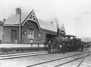
Waddamana is a rural locality in the local government area (LGA) of Central Highlands in the Central LGA region of Tasmania. The locality is about 64 kilometres (40 mi) north of the town of Hamilton. The 2016 census has a population of 4 for the state suburb of Waddamana. It is a former 'hydro-town', at the foot of the southern side of the Central Plateau of Tasmania.

The Lyell Highway is a highway in Tasmania, running from Hobart to Queenstown. It is the one of two transport routes that passes through the West Coast Range, the other being the Anthony Road.
Derwent Bridge is a rural locality in the local government area (LGA) of Central Highlands in the Central LGA region of Tasmania. The locality is about 101 kilometres (63 mi) north-west of the town of Hamilton. The 2021 Census it listed with a population of 40 for the state suburb of Derwent Bridge. It is on the Lyell Highway at the southern edge of the Cradle Mountain-Lake St Clair National Park.

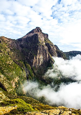
Central Plateau Conservation Area is an animal and plant conservation area in Tasmania, Australia. It is adjacent to the Walls of Jerusalem National Park.

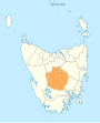
The Central Highlands is a region in Tasmania, Australia where geographical and administrative boundaries closely coincide. It is also known as The Lake Country of Tasmania.

The electoral division of Derwent is one of the 15 electoral divisions in the Tasmanian Legislative Council. It is situated in the central south of the state.

Hamilton is a rural locality in the local government area (LGA) of Central Highlands in the Central LGA region of Tasmania. The locality is about 73 kilometres (45 mi) north-west of the city of Hobart. The 2016 census recorded a population of 241 for the suburb of Hamilton.
South West Tasmania is a region in Tasmania that has evoked curiosity as to its resources over the duration of European presence on the island.
Tarraleah is a rural locality in the local government area (LGA) of Central Highlands in the Central LGA region of Tasmania. The locality is about 53 kilometres (33 mi) north-west of the town of Hamilton. The 2016 census has a population of nil for the state suburb of Tarraleah.
Bronte Park is a rural locality in the local government area (LGA) of Central Highlands in the Central LGA region of Tasmania. The locality is about 82 kilometres (51 mi) north-west of the town of Hamilton. The 2016 census recorded a population of 28 for the state suburb of Bronte Park. It is a locality on the Marlborough Highway at the southern edge of the Cradle Mountain-Lake St Clair National Park. It is located just north of the Lyell Highway and approximately halfway in between Hobart and Queenstown, and is also almost exactly in the geographic centre of the island.
Gretna is a rural locality in the local government areas (LGA) of Central Highlands and Derwent Valley in the Central and South-east LGA regions of Tasmania. The locality is about 20 kilometres (12 mi) south-east of the town of Hamilton. The 2016 census has a population of 211 for the state suburb of Gretna. It was formerly known as Stony Hut Plains, though the Gretna post office was known as Macquarie Plains for many years. It has a postcode of 7140.
Butlers Gorge is a rural locality in the local government area of Central Highlands in the Central region of Tasmania. It is located about 67 kilometres (42 mi) north-west of the town of Hamilton. The 2016 census determined a population of nil for the state suburb of Butlers Gorge.