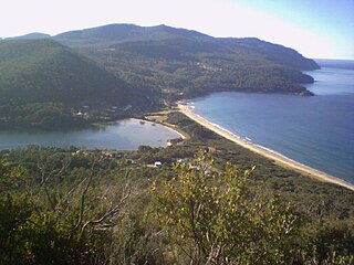
The Tasman National Park is a national park in eastern Tasmania, Australia, approximately 56 kilometres (35 mi) east of Hobart. The 107.5-square-kilometre (41.5 sq mi) park is situated on part of both the Forestier and Tasman peninsulas and encompasses all of Tasman Island.

The Tasman Peninsula, officially Turrakana / Tasman Peninsula, is a peninsula located in south-east Tasmania, Australia, approximately 75 km (47 mi) by the Arthur Highway, south-east of Hobart.

Huon Valley Council is a local government body in Tasmania, covering most of the south of the state. Huon Valley is classified as a rural local government area and has a population of 17,219, towns and localities of the region include Cygnet, Dover, Franklin, Geeveston, Southport and the largest principal town, Huonville.

Break O'Day Council is a local government body in Tasmania, situated in the northern part of the state's east coast. Break O'Day is classified as a rural local government area and has a population of 6,770, the major towns of the region include St Helens, St Marys and Scamander.
Dorset Council is a local government body in Tasmania, located in the far north-east of the state mainland. Dorset is classified as a rural local government area and has a population of 6,652. The major towns and localities of the region include Bridport, Derby and Ringarooma with Scottsdale the regional centre. Dorset was placed under a board of inquiry on 2 August 2023 and is currently under the supervision of commissioner Wardlaw. The current general manager is John Marik.
Waratah-Wynyard Council is a local government body in Tasmania, situated in the north-west of the state. Waratah-Wynyard is classified as a rural local government area and has a population of 13,800, the major towns and localities of the region include Savage River, Sisters Beach, Somerset, Waratah and the principal town of Wynyard.

Circular Head Council is a local government body in Tasmania covering the far north-west mainland. It is classified as a rural local government area with a population of 8,066, and its major towns and localities include Arthur River, Marrawah and Stanley, with Smithton being the largest and principal town. The origin of the name “Circular Head” is unknown.

Central Highlands Council is a local government body in Tasmania, encompassing the Central Highlands region of the state. Central Highlands is classified as a rural local government area and has a population of 2,144, the two largest towns are Bothwell and Hamilton.

The Forestier Peninsula is a peninsula located in south-east Tasmania, Australia, approximately 60 kilometres (37 mi) by the Arthur Highway, south-east of Hobart. The peninsula is connected to mainland Tasmania at East Bay Neck, near the town of Dunalley at its northern end. At Eaglehawk Neck, the southern end of the Forestier Peninsula is connected to the Tasman Peninsula.
The Arthur Highway (A9) is a Tasmanian highway which runs from Sorell in the near south to Port Arthur in the far south-east.

Eaglehawk Neck, officially Teralina / Eaglehawk Neck, is a narrow isthmus that connects the Tasman Peninsula with the Forestier Peninsula and hence to the rest of Tasmania, Australia.

Sorell Council is a local government body in Tasmania, situated in the south-east of the state. The Sorell local government area is classified as rural and has a population of 15,218, the major centres of the region include Dodges Ferry, Dunalley, Primrose Sands and the principal town of Sorell.

Launceston City Council is a local government body in Tasmania, located in the city and surrounds of Launceston in the north of the state. The Launceston local government area is classified as urban and has a population of 70,055, which also encompasses the localities including Lilydale, Targa and through to Swan Bay on the eastern side of the Tamar River.

Burnie City Council is a local government body in Tasmania, located in the city and surrounds of Burnie in the north-west of the state. The Burnie local government area is classified as urban and has a population of 19,348, which also encompasses Cooee, Hampshire, Natone and Ridgley.
King Island Council is a local government body in Tasmania, encompassing King Island and the adjacent minor islands within Bass Strait, in the north-west of the state. The King Island local government area is classified as rural and has a population of 1,601, with Currie as the main town and administrative centre.

Flinders Council is a local government body in Tasmania, encompassing the Furneaux Group and nearby islands of Bass Strait, in the north-east of the state. Flinders is classified as a rural local government area and has a population of 987, with Whitemark the main town located on Flinders Island.
Taranna is a rural locality in the local government area (LGA) of Tasman in the South-east LGA region of Tasmania. The locality is about 16 kilometres (9.9 mi) north-east of the town of Nubeena. The 2016 census recorded a population of 156 for the state suburb of Taranna. It is a hamlet on the Tasman Peninsula. Local points of interest include its Presbyterian church, immediately adjacent to the Federation Chocolate Factory, and a Tasmanian Devil park, "Unzoo".
The Peninsula Football Association (PFA) is a former non-professional Australian Rules football league from south-eastern Tasmania, Australia that operated between 1988 and 2001.

Koonya is a rural locality in the local government area (LGA) of Tasman in the South-east LGA region of Tasmania. The locality is about 18 kilometres (11 mi) north-east of the town of Nubeena. The 2016 census has a population of 134 for the state suburb of Koonya. It hosts the annual Koonya Garlic Festival, a "one-day celebration".
Cape Raoul is a rural locality and a natural feature in the local government area of Tasman in the South-east region of Tasmania. It is located about 13 kilometres (8.1 mi) south of the town of Nubeena. The 2016 census determined a population of nil for the state suburb of Cape Raoul.


