
Inyo County is a county in the eastern central part of the U.S. state of California, located between the Sierra Nevada and the state of Nevada. In the 2020 census, the population was 19,016. The county seat is Independence. Inyo County is on the east side of the Sierra Nevada and southeast of Yosemite National Park in Central California. It contains the Owens River Valley; it is flanked to the west by the Sierra Nevada and to the east by the White Mountains and the Inyo Mountains. With an area of 10,192 square miles (26,400 km2), Inyo is the second-largest county by area in California, after San Bernardino County. Almost one-half of that area is within Death Valley National Park. However, with a population density of 1.8 people per square mile, it also has the second-lowest population density in California, after Alpine County.

Kern County is a county located in the U.S. state of California. As of the 2020 census, the population was 909,235. Its county seat is Bakersfield.

Inyokern is a census-designated place (CDP) in Kern County, California, United States. Its name derives from its location near the border between Inyo and Kern Counties. Inyokern is located 8 miles (13 km) west of Ridgecrest, at an elevation of 2,434 feet (742 m). It is on the western side of the Indian Wells Valley. The population was 988 in the 2020 census, down from 1,099 in the 2010 census. It was a railroad town established along the Southern Pacific railroad's Lone Pine Branch and with WWII became site of the Naval Air Weapons Station China Lake.
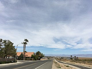
Ridgecrest is a city in Kern County, California, United States, along U.S. Route 395 in the Indian Wells Valley in northeastern Kern County, adjacent to the Naval Air Weapons Station China Lake. It was incorporated as a city in 1963. The population was 27,959 at the 2020 census, up slightly from 27,616 at the 2010 census.

Mammoth Lakes is a town in Mono County, California, and is the county's only incorporated community. It is located immediately to the east of Mammoth Mountain, at an elevation of 7,880 feet (2,400 m). As of the 2020 United States Census, the population was 7,191, reflecting a 12.7% decrease from the 2010 Census.

Walker Pass is a mountain pass by Lake Isabella in the southern Sierra Nevada. It is located in northeastern Kern County, approximately 53 mi (85 km) ENE of Bakersfield and 10 mi (16 km) WNW of Ridgecrest. The pass provides a route between the Kern River Valley and San Joaquin Valley on the west, and the Mojave Desert on the east.
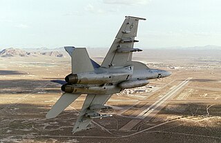
Naval Air Weapons Station (NAWS) China Lake is a large military installation in California that supports the research, testing and evaluation programs of the United States Navy. It is part of Navy Region Southwest under Commander, Navy Installations Command, and was originally known as Naval Ordnance Test Station (NOTS).

The Coso Volcanic Field is located in Inyo County, California, at the western edge of the Basin and Range geologic province and northern region of the Mojave Desert. The Fossil Falls are part of the Coso Field, created by the prehistoric Owens River. They are within the Naval Air Weapons Station China Lake and northeast of Little Lake and U.S. Route 395.
The Coso Range of eastern California is located immediately south of Owens Lake, east of the Sierra Nevada, and west of the Argus Range. The southern part of the range lies in the restricted Naval Air Weapons Station China Lake and the northern part of the range is designated as the Coso Range Wilderness. The mountains include Coso Peak, at 8,160 feet (2,487 m) above sea level, as well as Silver Peak and Silver Mountain, both more than 7,400 ft (2,300 m) in height.

The Kawaiisu are a Native Californian ethnic group in the United States who live in the Tehachapi Valley and to the north across the Tehachapi Pass in the southern Sierra Nevada, toward Lake Isabella and Walker Pass. Historically, the Kawaiisu also traveled eastward on food-gathering trips to areas in the northern Mojave Desert, to the north and northeast of the Antelope Valley, Searles Valley, as far east as the Panamint Valley, the Panamint Mountains, and the western edge of Death Valley. Today, some Kawaiisu people are enrolled in the Tule River Indian Tribe.
The Timbisha are a Native American tribe federally recognized as the Death Valley Timbisha Shoshone Band of California. They are known as the Timbisha Shoshone Tribe and are located in south central California, near the Nevada border. As of the 2010 Census the population of the Village was 124. The older members still speak the ancestral language, also called Timbisha.
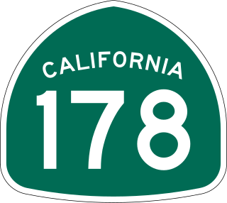
State Route 178 is a state highway in the U.S. state of California that exists in two constructed segments. The gap in between segments is connected by various local roads and State Route 190 through Death Valley National Park. The western segment runs from State Route 99 in Bakersfield and over the Walker Pass in the Sierra Nevada to the turnoff for the Trona Pinnacles National Natural Landmark. The eastern segment runs from the southeasterly part of Death Valley to Nevada State Route 372 at the Nevada state line.
The Scodie Mountains are a sub-mountain range of the Southern Sierra Nevada rising from the Mojave Desert, and located in Kern County, California.

Coso Rock Art District is a rock art site containing over 100,000 Petroglyphs by Paleo-Indians and/or Native Americans. The district is located near the towns of China Lake and Ridgecrest, California. Big and Little Petroglyph Canyons were declared a National Historic Landmark in 1964. In 2001, they were incorporated into this larger National Historic Landmark District. There are several other distinct canyons in the Coso Rock Art District besides the Big and Little Petroglyph Canyons. Also known as Little Petroglyph Canyon and Sand Tanks, Renegade Canyon is but one of several major canyons in the Coso Range, each hosting thousands of petroglyphs. The majority of the Coso Range images fall into one of six categories: bighorn sheep, entopic images, anthropomorphic or human-like figures, other animals, weapons & tools, and "medicine bag" images. Scholars have proposed a few potential interpretations of this rock art. The most prevalent of these interpretations is that they could have been used for rituals associated with hunting.
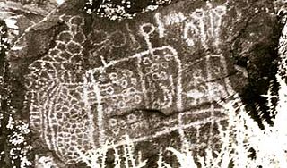
Big and Little Petroglyph Canyons are two principal landforms within which are found major accumulations of Paleo-Indian and/or Native American Petroglyphs, or rock art, by the Coso People located in the Coso Range Mountains of the northern Mojave Desert, and now within the Naval Air Weapons Station China Lake, near the towns of China Lake and Ridgecrest, California. Little Petroglyph Canyon contains 20,000 documented images, which surpasses in number for most other collections. Additionally, the archeological resources are remarkably undisturbed.

U.S. Route 395 (US 395) is a United States Numbered Highway, stretching from Hesperia, California to the Canadian border in Laurier, Washington. The California portion of US 395 is a 557-mile (896 km) route which traverses from Interstate 15 (I-15) in Hesperia, north to the Oregon state line in Modoc County near Goose Lake. The route clips into Nevada, serving the cities Carson City and Reno, before returning to California.

Maturango Museum is located in Ridgecrest, California. The museum is best known for the guided tours of the Coso Rock Art District located on China Lake Naval Weapons Station. The museum offers exhibits and displays featuring both the natural and the cultural history and diversity of the Northern Mojave Desert with exhibits of animals, plants, rocks and minerals, Native American artifacts, and contemporary arts and crafts.

China Lake is an unincorporated community in Kern County, California. It is located 2.5 miles (4 km) north-northeast of Ridgecrest, at an elevation of 2,264 feet. The place is on China Lake, a dry lake on the Naval Air Weapons Station China Lake.
Betty Spindler is an American ceramist, known for her ceramic renditions of fruits, vegetables, and other foods through clay, newspaper, and vibrant colors.
The 2019 Ridgecrest earthquakes of July 4 and 5 occurred north and northeast of the town of Ridgecrest, California located in Kern County and west of Searles Valley. They included three initial main shocks of magnitudes 6.4, 5.4, and 7.1, and many perceptible aftershocks, mainly within the area of the Naval Air Weapons Station China Lake. Eleven months later, a Mw 5.5 aftershock took place to the east of Ridgecrest. The first main shock occurred on Thursday, July 4 at 10:33 a.m. PDT, approximately 18 km (11.2 mi) ENE of Ridgecrest, and 13 km (8.1 mi) WSW of Trona, on a previously unnoticed NE-SW trending fault where it intersects the NW-SE trending Little Lake Fault Zone. This quake was preceded by several smaller earthquakes, and was followed by more than 1,400 detected aftershocks. The M 5.4 and M 7.1 quakes struck on Friday, July 5 at 4:08 a.m. and 8:19 p.m. PDT approximately 10 km (6 miles) to the northwest. The latter, now considered the mainshock, was the most powerful earthquake to occur in the state in 20 years. Subsequent aftershocks extended approximately 50 km (~30 miles) along the Little Lake Fault Zone.
