Hanahan is a city in Berkeley County, South Carolina, United States. The population was 12,937 at the 2000 census. The 2010 census puts the population at 17,997. Portions of the Naval Weapons Station Charleston, including the Naval Consolidated Brig Charleston, are located in Hanahan. As defined by the U.S. Office of Management and Budget, and used by the U.S. Census Bureau for statistical purposes only, Hanahan is included within the Charleston-North Charleston-Summerville metropolitan area and the Charleston-North Charleston Urbanized Area.

Goose Creek is the most populous city in Berkeley County in the U.S. state of South Carolina. The population was 45,946 at the 2020 census, making it the 7th-most populous city in the state. Most of the Naval Weapons Station Charleston is in Goose Creek. As defined by the U.S. Office of Management and Budget, and used only by the U.S. Census Bureau and other federal agencies for statistical purposes, Goose Creek is included within the Charleston-North Charleston, SC Metropolitan Statistical Area.

Naval Submarine Base Kings Bay is a base of the United States Navy located adjacent to the city of St. Marys in Camden County, Georgia, on the East River in southeastern Georgia, and 38 miles (61 km) from Jacksonville, Florida. The Submarine Base is the U.S. Atlantic Fleet's home port for U.S. Navy Fleet ballistic missile nuclear submarines capable of being armed with Trident missile nuclear weapons. This submarine base covers about 16,000 acres of land, of which 4,000 acres are protected wetlands.

Charleston Air Force Base is a United States military facility located in the City of North Charleston, South Carolina. The facility is under the jurisdiction of the United States Air Force's 628th Air Base Wing, a subordinate element of the Air Mobility Command (AMC). It is part of Joint Base Charleston, which combined Charleston Air Force Base with Naval Support Activity Charleston.

Charleston Naval Shipyard was a U.S. Navy ship building and repair facility located along the west bank of the Cooper River, in North Charleston, South Carolina and part of Naval Base Charleston.

Coast Guard Base Alameda also referred to as Coast Guard Island is an artificial island in the Oakland Estuary between Oakland and Alameda, California. It is home to several major United States Coast Guard commands and cutters, including the Coast Guard Pacific Area. It is one of the largest Coast Guard bases on the West Coast. From 1942 until 1982, the island was the site of the Coast Guard's recruiting training center, enlisting and training hundreds of thousands of Coast Guardsmen including many of the 214,239 who served in the Pacific and European Theaters of World War II.
The history of the United States Coast Guard goes back to the United States Revenue Cutter Service, which was founded on 4 August 1790 as part of the Department of the Treasury. The Revenue Cutter Service and the United States Life-Saving Service were merged to become the Coast Guard per 14 U.S.C. § 1 which states: "The Coast Guard as established January 28, 1915, shall be a military service and a branch of the armed forces of the United States at all times." In 1939 the United States Lighthouse Service was merged into the Coast Guard. The Coast Guard itself was moved to the Department of Transportation in 1967, and on 1 March 2003 it became part of the Department of Homeland Security. However, under 14 U.S.C. § 3 as amended by section 211 of the Coast Guard and Maritime Transportation Act of 2006, upon the declaration of war and when Congress so directs in the declaration, or when the President directs, the Coast Guard operates as a service in the Department of the Navy.
The structure of the United States Navy consists of four main bodies: the Office of the Secretary of the Navy, the Office of the Chief of Naval Operations, the operating forces, and the Shore Establishment.

Naval Base Guam is a strategic U.S. naval base located on Apra Harbor and occupying the Orote Peninsula. In 2009, it was combined with Andersen Air Force Base to form Joint Region Marianas, which is a Navy-controlled joint base.

MV Charles L. Gilliland, formerly USNS Gilliland (T-AKR-298), is a Gordon-class roll on roll off vehicle cargo ship of the United States Navy. She was originally built as a merchant vessel but later acquired and converted by the Navy, and assigned to the United States Department of Defense's Military Sealift Command. Gilliland was built in 1972 as MV Selandia. After some time spent in commercial service she was lengthened by Hyundai Heavy Industries in 1984, and later went on to be acquired by the US Navy under a long term charter. She was converted to a US Navy Vehicle Roll-on/Roll-off Ship at Newport News Shipbuilding and Drydock Company in Newport News, Virginia, in a contract dated 23 May 1997 and on completion was assigned to the Military Sealift Command under the name USNS Gilliland, after Medal of Honor recipient Corporal Charles L. Gilliland. Gilliland is one of 28 Strategic Sealift Ships operated by the Military Sealift Command. She was assigned to the MSC Atlantic surge force, and is maintained in Ready Operational Status 4.

The Cape Ducato class are five roll-on/roll-off vehicle cargo ships of the United States Navy used to rapidly transport US military unit equipment such as tanks, helicopters, wheeled vehicles and other heavy equipment, to support deployed forces worldwide.
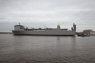
MV Cape Ducato (T-AKR-5051) was delivered in September 1972, as MV Barranduna at Eriksbergs Mekaniska Verkstads AB, Sweden. She was acquired by the US Maritime Administration (MARAD) on 18 November 1985 and renamed MV Cape Ducato. She was assigned to MARAD Ready Reserve Force, (RRF) and is one of the Military Sealift Command's (MSC) 31 Roll-on/Roll-off ships and one of the 63 ships of the Sealift Program Office. Cape Ducato is laid up as part of the National Defense Reserve Fleet in a layberth at Joint Base Charleston in North Charleston, South Carolina in ROS-5 status.

Joint Base Charleston is a United States military facility located partly in the City of North Charleston, South Carolina and partly in the City of Goose Creek, South Carolina. The facility is under the jurisdiction of the United States Air Force 628th Air Base Wing, Air Mobility Command (AMC).

Naval Support Activity Charleston, originally designated Naval Weapons Station Charleston, is a base of the United States Navy located on the west bank of the Cooper River, in the cities of Goose Creek and Hanahan South Carolina. The base encompasses more than 17,000 acres (69 km2) of land with 10,000 acres (40 km2) of forest and wetlands, 16-plus miles of waterfront, four deep-water piers, 38.2 miles (61.5 km) of railroad and 292 miles (470 km) of road. The current workforce numbers more than 11,000 with an additional 3,600 people in on-base family housing.

In the United States Navy, United States Coast Guard, United States Public Health Service Commissioned Corps (USPHS), and National Oceanic and Atmospheric Administration Commissioned Officer Corps, captain is the senior-most commissioned officer rank below that of flag officer. The equivalent rank is colonel in the United States Army, Air Force, Space Force, and Marine Corps.
The 648-foot roll-on/roll-off and container ship MV Cape Ray (T-AKR-9679), built in 1977, was previously known as MV Saudi Makkah and MV Seaspeed Asia. She can carry 1,315 containers and has both bow and stern thrusters.

MV Cape Edmont (T-AKR-5069),, was a Cape E-class roll-on/roll-off built in 1971.
MV Cape Lambert (T-AKR-5077),, was a Cape L-class roll-on/roll-off built in 1973.