
Cheung Chau is an island 10 kilometres southwest of Hong Kong Island. It is nicknamed the 'dumbbell island (啞鈴島)' due to its shape. It has been inhabited for longer than most other places in Hong Kong, and had a population of 22,740 as of 2011. Administratively, it is part of the Islands District.
Hong Kong has a long coastline that is full of twists and turns with many bays and beaches. Many of them are well sheltered by mountains nearby, as Hong Kong is a mountainous place. As a result, large waves seldom appear at the bays, making them suitable for human swimming.

Tung Lung Chau, previously known as Nam Tong Island or Nam Fat Tong is an island located off the tip of the Clear Water Bay Peninsula in the New Territories of Hong Kong. It is also referred by Hong Kong people as Tung Lung To or Tung Lung Island (東龍島). The island is largely uninhabited. Administratively, it belongs to Sai Kung District.
Pui O Beach is a gazetted beach running along almost the entire shoreline of Pui O in Lantau Island, Hong Kong, facing Pui O Wan and neighbouring Chi Ma Wan Peninsula. The beach has barbecue pits and is managed by the Leisure and Cultural Services Department of the Hong Kong Government. The beach is 260 metres long and is rated as good to fair by the Environmental Protection Department for its water quality in the past twenty years. The water flow of Pui O Beach comes from the sea and nearby rivers, so Pui O Beach is the junction of fresh water.

Ma Wan Tung Wan Beach is a gazetted beach near Noah's Ark on Ma Wan island, Hong Kong. The beach is managed by the Leisure and Cultural Services Department of the Hong Kong Government. The beach is 140 metres long and is rated as Grade 2 by the Environmental Protection Department for its water quality. It is the only beach in Ma Wan that is open to the public and offers views of Ting Kau Bridge as well as Tsing Ma Bridge.
Declared monuments of Hong Kong are places, structures or buildings legally declared to receive the highest level of protection. In Hong Kong, declaring a monument requires consulting the Antiquities Advisory Board, the approval of the chief executive as well as the publication of the notice in government gazette.
Big Wave Bay Beach is a gazetted beach next to Big Wave Bay, Shek O, Southern District, Hong Kong. The beach has barbecue pits and is managed by the Leisure and Cultural Services Department of the Hong Kong Government. The beach is 86 metres long and is rated as Grade 1 by the Environmental Protection Department for its water quality. This beach is popular among surfers and is also the site of a prehistoric rock carving, which is a declared monument.

Shek O is an area of the south-eastern part of Hong Kong Island, in Hong Kong. It can refers to Shek O village or Shek O Peninsula or Shek O Headland. Administratively, they are part of Southern District.

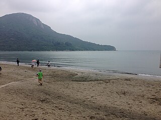
Kwun Yam Beach, also known as Afternoon Beach, is a gazetted beach facing Kwun Yam Wan on the east coast of Cheung Chau, Hong Kong. The beach is managed by the Leisure and Cultural Services Department of the Hong Kong Government. The beach is 100 metres long and is rated as Grade 1 by the Environmental Protection Department for its water quality. It is one of the two beaches in Cheung Chau along with Cheung Chau Tung Wan Beach and the beach is smaller than Cheung Chau Tung Wan Beach in the island.

Shek Pik is an area located along the southwestern coast of Lantau Island, Hong Kong. When the Shek Pik Reservoir was built, villages at Shek Pik were demolished and the villagers were relocated to other parts of Lantau Island and to Tsuen Wan. Below the dam of the reservoir is Shek Pik Prison.

Prehistoric Hong Kong is the period between the arrival of the first humans in Hong Kong and the start of recorded Chinese history first appeared during the Han dynasty. The history of the southern region is reckoned to have been first recorded in 214 BC with Qin Shi Huang conquering the Baiyue and creating the Jiaozhou province.

Tong Fuk Beach is a gazetted beach located on South Lantau Road in Tong Fuk, Lantau Island, Hong Kong. The beach is managed by the Leisure and Cultural Services Department of the Hong Kong Government. The beach is 150 metres long and is rated as good to fair by the Environmental Protection Department for its water quality in the past twenty years. It is a popular holiday resort in Lantau Island.

Tin Hau temples in Hong Kong are dedicated to Tin Hau (Mazu). Over 100 temples are dedicated to Tin Hau in Hong Kong. A list of these temples can be found below.

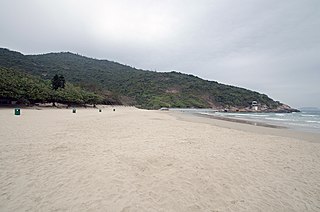
Lower Cheung Sha Beach is a gazetted beach located in Cheung Sha in southern Lantau Island, Hong Kong. The beach is managed by the Leisure and Cultural Services Department of the Hong Kong Government. The beach is 96 metres long and is rated as good to fair by the Environmental Protection Department for its water quality in the past twenty years. Near the beach is the Upper Cheung Sha Beach, but the Upper Cheung Sha Beach is not connected to the Lower Cheung Sha Beach.

Upper Cheung Sha Beach is a gazetted beach in Cheung Sha in southern Lantau Island, Hong Kong. The beach has barbecue pits and is managed by the Leisure and Cultural Services Department of the Hong Kong Government. The beach is rated as good to fair by the Environmental Protection Department for its water quality in the past twenty years. It is still the longest beach in Hong Kong.

Shap Long Reservoir, built in 1955, is a reservoir located in Chi Ma Wan Peninsula and Lantau South Country Park in Chi Ma Wan, Lantau Island, Hong Kong. The Chi Ma Wan Country Trail and the Chi Ma Wan Mountain Bike Trail pass through the reservoir. The reservoir used to be the main water source for the residents of Cheung Chau, Peng Chau and Hei Ling Chau in the Islands District before being converted into an irrigation reservoir in the 1970s.

Chung Hom Kok Beach is a gazetted beach next to Chung Hom Wan located on the western shore of Chung Hom Kok, Southern District, Hong Kong. The beach has barbecue pits and is managed by the Leisure and Cultural Services Department of the Hong Kong Government. The beach is rated as Grade 1 by the Environmental Protection Department for its water quality.

Stanley Main Beach is a gazetted beach located adjacent to Stanley Market and Stanley Back Beach in the eastern side of the Stanley peninsula, Southern District, Hong Kong. The beach has barbecue pits and is managed by the Leisure and Cultural Services Department of the Hong Kong Government. The beach is about 194 metres long and is rated as Grade 1 by the Environmental Protection Department for its water quality.

Rocky Bay Beach is a gazetted beach located behind Shek O Beach in Shek O, Southern District, Hong Kong. The beach is managed by the Leisure and Cultural Services Department of the Hong Kong Government. The beach did not get its grading and it is currently not open for swimming as no lifeguard facilities are available.

Clear Water Bay First Beach is a gazetted beach located in the northern part of Clear Water Bay in Clear Water Bay Peninsula, Sai Kung District, Hong Kong. The beach has barbecue pits and is managed by the Leisure and Cultural Services Department of the Hong Kong Government. The beach is 108 metres long and is rated as good to fair by the Environmental Protection Department for its water quality in the past twenty years. The first and second beaches are separated by a short stretch of rocky coast and interconnecting footpath.

