Christine Siddoway

Last updated
Christine Siddoway
Christine Smith Siddoway, Antarctica investigator.jpg
Born(1961-12-26)December 26, 1961
NationalityAmerican
Other namesChristine Helen Smith, Christine H. Smith, Christine Smith Siddoway
Alma materBSc Carleton College, 1984
MSc University of Arizona, 1987
PhD University of California-Santa Barbara, 1995
AwardsFellow of the Geological Society of America
Member of Sigma Xi, the Scientific Research Honor Society
Antarctic Service Medal
Scientific career
Fields Structural geology
Tectonics
Institutions Colorado College
Website sites.coloradocollege.edu/csiddoway/

Christine Siddoway is an American Antarctic researcher, best known for her work on the geology and tectonics of the Ford Ranges in western Marie Byrd Land. [1] [2] Other discoveries relate to preserved records of continental-interior sedimentation during the Sturtian glaciation, Cryogenian Period, in Rodinia, and evidence of a reduced Pliocene extent of the West Antarctic ice sheet, [3] based upon investigation of clasts transported to/deposited in deep water by Ice rafting in the Amundsen Sea.

Contents

Early life and education

Siddoway completed her undergraduate education at Carleton College in 1984. Siddoway received a master's degree in 1987 from the University of Arizona, then attended the University of California, Santa Barbara where she earned her Ph.D in 1995. [4] Her dissertation focused on the only known gneiss dome in Antarctica, in the Fosdick Mountains, Marie Byrd Land. As graduate student, she began the first of a series of studies in the Fosdick Metamorphic Complex in Marie Byrd Land with her PhD advisor and project principal investigator Bruce Luyendyk. [5] [6] [7]

Career and impact

Siddoway's career includes 12 field research seasons in Antarctica since 1989, plus additional Polar Programs research that entailed laboratory and geospatial work. [8] During initial work in Marie Byrd Land, the central issue was when and how mid crustal rocks found in the Fosdick Metamorphic Complex became exhumed. Her work demonstrated a role for doming, anatexis, and intrusion, within a regional context of right lateral strike slip—leading to a model of rapid exhumation via transtension rather than orthogonal extension as in a core complex. The detachment fault of the core complex, when found, was discovered to display dextral oblique striae and constrictional fabrics [9] [10] She continued to refine the fundamentals of the process of gneiss dome emplacement authoring a special publication on that topic with the Fosdick range as a type model. [11] An outgrowth of the early work explored the Fosdick Mountains gneiss dome as a repository of information about crustal differentiation leading to stabilization of the landmass of Marie Byrd Land within the Antarctic continent. [12]

Siddoway aided the founding of the SCAR ANTscape project in 2009, which stimulated research leading to reconstruction of bedrock topography of Antarctica for key intervals of the geologic past—an important parameter for understanding the origins and evolution of the Antarctic ice sheet. [13] [14] More recently, she collaborated with GNS Science and Polar Geospatial Center colleagues to develop Antarctic GeoMap, [15] under the auspices of the Scientific Committee on Scientific Research. [16]

Siddoway's Antarctic work has been funded by the U.S. National Science Foundation, with ten NSF Polar Programs grants received over 22 years. [8] [17] The recent ROSETTA-Ice Project was a collaboration with co-investigators from Columbia University, UC San Diego, and Earth Space Research, with a prevalence of women PIs, to study the framework of the Ross Ice Shelf and Ross Embayment, ROSETTA-ice. [18] The project used airborne geophysics and on-ground investigations and was funded by the National Science Foundation and the Moore Foundation. [19]

Along with her work in Antarctica, Siddoway has pursued research in the Front Range of the Colorado Rocky Mountains. [20] [21] [22] This work led to a surprising result for the age of Cryogenian sandstone dikes within granite host rock, a matter that had been unresolved for more than 125 years. [20] [23] The Tavakaiv quartzite formation contributes to new appreciation of the time of formation [24] of The Great Unconformity in Colorado.

She is currently working on Ice sheet erosional Interaction with Hot Geotherm, ICI-Hot in West Antarctica, [25] International Ocean Discovery Program (IODP) 379, 2019-2021 Amundsen SeaWest Antarctic Ice Sheet History, Cryogenian intracontinental sedimentary records for Rodinia, [26] and Testing the linchpin of WAIS collapse with diatoms and ice rafted debris in Pleistocene and Late Pliocene strata of the Resolution Drift. [27]

Siddoway has served on committees of the Geological Society of America, including as Associate Editor for the GSA Bulletin. [28] She has also served twice on the Organizing Committee for the International Symposium on Antarctic Earth Sciences (1995, 2007) and on the Transantarctic Mountain Science Planning Committee (2015). [29]

Awards and honors

Siddoway was elected a Fellow of the Geological Society of America in 2009 [30] and received the Antarctica Service Medal in 2003. [31] In 2021, she was elected to Sigma Xi, the Scientific Research Honor Society. [32] [ circular reference ] She was awarded a Fulbright Post-doctoral Research Fellowship in Italy in 1995.

Selected works

Related Research Articles

<span class="mw-page-title-main">Ross Sea</span> Deep bay of the Southern Ocean in Antarctica

The Ross Sea is a deep bay of the Southern Ocean in Antarctica, between Victoria Land and Marie Byrd Land and within the Ross Embayment, and is the southernmost sea on Earth. It derives its name from the British explorer James Clark Ross who visited this area in 1841. To the west of the sea lies Ross Island and Victoria Land, to the east Roosevelt Island and Edward VII Peninsula in Marie Byrd Land, while the southernmost part is covered by the Ross Ice Shelf, and is about 200 miles (320 km) from the South Pole. Its boundaries and area have been defined by the New Zealand National Institute of Water and Atmospheric Research as having an area of 637,000 square kilometres (246,000 sq mi).

<span class="mw-page-title-main">Marie Byrd Land</span> Unclaimed West Antarctic region

Marie Byrd Land (MBL) is an unclaimed region of Antarctica. With an area of 1,610,000 km2 (620,000 sq mi), it is the largest unclaimed territory on Earth. It was named after the wife of American naval officer Richard E. Byrd, who explored the region in the early 20th century.

<span class="mw-page-title-main">West Antarctica</span> Part of Antarctica that lies within the Western Hemisphere

West Antarctica, or Lesser Antarctica, one of the two major regions of Antarctica, is the part of that continent that lies within the Western Hemisphere, and includes the Antarctic Peninsula. It is separated from East Antarctica by the Transantarctic Mountains and is covered by the West Antarctic Ice Sheet. It lies between the Ross Sea, and the Weddell Sea. It may be considered a giant peninsula, stretching from the South Pole towards the tip of South America.

<span class="mw-page-title-main">Fosdick Mountains</span> Mountain range in Marie Byrd Land, Antarctica

The Fosdick Mountains are an east–west trending mountain range with marked serrate outlines, standing along the south side of Balchen Glacier at the head of Block Bay, in the Ford Ranges of Marie Byrd Land, Antarctica.

<span class="mw-page-title-main">Cape Colbeck</span> Headland of Antarctica

Cape Colbeck is a prominent ice-covered cape which forms the northwestern extremity of the Edward VII Peninsula and Marie Byrd Land in Antarctica. It was discovered in January 1902 by the British National Antarctic Expedition and named for Captain William Colbeck, Royal Naval Reserve, who commanded Robert Scott's relief ship, the Morning.

<span class="mw-page-title-main">West Antarctic Rift System</span> Series of rift valleys between East and West Antarctica

The West Antarctic Rift System is a series of rift valleys between East and West Antarctica. It encompasses the Ross Embayment, the Ross Sea, the area under the Ross Ice Shelf and a part of Marie Byrd Land in West Antarctica, reaching to the base of the Antarctic Peninsula. It has an estimated length of 3,000 km (1,900 mi) and a width of approximately 700 km (430 mi). Its evolution is due to lithospheric thinning of an area of Antarctica that resulted in the demarcation of East and West Antarctica. The scale and evolution of the rift system has been compared to that of the Basin and Range Province of the Western United States.

<span class="mw-page-title-main">Geology of Antarctica</span> Geologic composition of Antarctica

The geology of Antarctica covers the geological development of the continent through the Archean, Proterozoic and Phanerozoic eons.

<span class="mw-page-title-main">The Billboard</span>

The Billboard is a massive granite monolith in the Sarnoff Mountains of the Ford Ranges of Marie Byrd Land, West Antarctica, standing just west of Mount Rea between Arthur Glacier and Boyd Glacier. It was discovered in November 1934 by a Second Byrd Antarctic Expedition (1933–35) sledge party under Paul Siple, and is so named because of its form and appearance with vertical faces rising above the continental ice.

<span class="mw-page-title-main">Mount Iphigene</span> Mountain in Marie Byrd Land, Antarctica

Mount Iphigene ; a mountain just west of Ochs Glacier between Marujupu Peak and Birchall Peaks, in the Fosdick Mountains, Ford Ranges, Marie Byrd Land, Antarctica. It is composed of Fosdick Metamorphic Rocks migmatite and granite of Cretaceous age. Its peak elevation is estimated at 1080 m. Discovered in 1929 by the Byrd Antarctic Expedition, they are named by Byrd for Iphigene Ochs Sulzberger, daughter of Adolph Ochs and wife of Arthur Sulzberger, patrons of the expedition.

The Phillips Mountains are a range of mountains on the north side of Balchen Glacier and Block Bay in the Ford Ranges, Marie Byrd Land, Antarctica.

Thompson Ridge is a rock ridge, 2 nautical miles (3.7 km) long and trending north–south on the south shore of Block Bay, 2.1 nautical miles (3.5 km) northwest of Mount Luyendyk, Fosdick Mountains in Marie Byrd Land, Antarctica. It is composed wholly of Fosdick Metamorphic Rocks. These are determined to be of Cretaceous age.

<span class="mw-page-title-main">East Antarctic Shield</span> Cratonic rock body which makes up most of the continent Antarctica

The East Antarctic Shield or Craton is a cratonic rock body that covers 10.2 million square kilometers or roughly 73% of the continent of Antarctica. The shield is almost entirely buried by the East Antarctic Ice Sheet that has an average thickness of 2200 meters but reaches up to 4700 meters in some locations. East Antarctica is separated from West Antarctica by the 100–300 kilometer wide Transantarctic Mountains, which span nearly 3,500 kilometers from the Weddell Sea to the Ross Sea. The East Antarctic Shield is then divided into an extensive central craton that occupies most of the continental interior and various other marginal cratons that are exposed along the coast.

<span class="mw-page-title-main">Terry Wilson (scientist)</span> International leader in the study of present-day tectonics in Antarctica

Terry Jean Wilson is an international leader in the study of present-day tectonics in Antarctica. She has led large, international efforts, such as Polar Earth Observing Network (POLENET), to investigate the interactions between the Earth's crust and the cryosphere in Antarctica.

<span class="mw-page-title-main">Robin Bell (scientist)</span> American geophysicist

Robin Elizabeth Bell is Palisades Geophysical Institute (PGI) Lamont Research Professor at Columbia University's Lamont–Doherty Earth Observatory and a past President of the American Geophysical Union (AGU), 2019–2021. Dr. Bell was influential in co-ordinating the 2007 International Polar Year and was the first woman to chair the National Academy of Sciences Polar Research Board. She has made numerous important discoveries with regard to subglacial lakes and ice sheet dynamics, and has a ridge, called Bell Buttress, in Antarctica named after her.

<span class="mw-page-title-main">Julie Palais</span> American glaciologist (born 1956)

Julie Michelle Palais is an American polar glaciologist who has made significant contributions to climate change research studying volcanic fallout in ice cores from both Greenland and Antarctica. For many years, starting in 1990, she played a pivotal role working at the National Science Foundation (NSF) as Program Director of the Antarctic Glaciology Program in the Division of Polar Programs, including many trips to both North and South Polar regions. Both the Palais Glacier and Palais Bluff in Antarctica were named in her honor and she has received many further recognitions for her distinguished career.

<span class="mw-page-title-main">Mount Luyendyk</span> Mountain in Marie Byrd Land, Antarctica

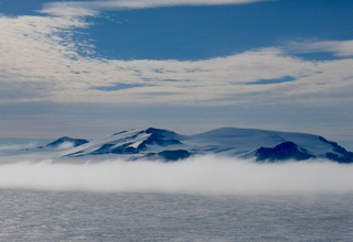
Mount Luyendyk is a summit in the western Fosdick Mountains of the Ford Ranges of Marie Byrd Land, West Antarctica. It forms a prominent exposure in the northwestern Iphigene massif. The peak is named in recognition of Bruce P. Luyendyk, professor (emeritus), University of California, Santa Barbara, who was active in ground- and ocean-based Antarctic research from 1989 to 2015, significantly advancing the scientific knowledge of the Ross Embayment region of Antarctica. Luyendyk led two on-land expeditions in the Ford Ranges, and was principal investigator for five marine geophysical expeditions in the Ross Sea.

<span class="mw-page-title-main">Bruce P. Luyendyk</span> American geophysicist and oceanographer (born 1943)

Bruce Peter Luyendyk is an American geophysicist and oceanographer, currently professor emeritus of marine geophysics at the University of California, Santa Barbara. His work spans marine geology of the major ocean basins, the tectonics of southern California, marine hydrocarbon seeps, and the tectonics and paleoclimate of Antarctica. His research includes tectonic rotations of the California Transverse Ranges, participation in the discovery of deep-sea hydrothermal vents, quantitative studies of marine hydrocarbon seeps, and geologic exploration of the Ford Ranges in Marie Byrd Land, Antarctica.

<span class="mw-page-title-main">Ross Embayment</span> Region of Antarctica

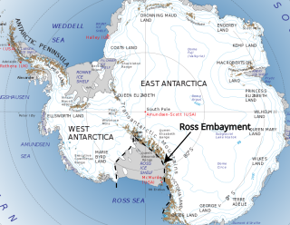
The Ross Embayment is a large region of Antarctica, comprising the Ross Ice Shelf and the Ross Sea, that lies between East and West Antarctica.

Anne Grunow is a senior research scientist at Ohio State University in the Byrd Polar Research Center. She is also the current director of the Polar Rock Repository. Grunow is a geologist specializing in Antarctic tectonics, with her research using methods from geochronology and paleomagnetism.

Kirsteen Jane Tinto is a glaciologist known for her research on the behavior and subglacial geology of the Greenland and Antarctic ice sheets.

References

  1. Siddoway, Christine (2010). "Tectonics: Microplate motion". Nature Geoscience. 3 (4): 225–226. Bibcode:2010NatGe...3..225S. doi:10.1038/ngeo835.
  2. Bell, Robin (2016-02-24). "Changes on the ice". Nature. 530 (7591): 507. doi: 10.1038/nj7591-507a .
  3. Amos, Jonathan (28 April 2021). "Climate change: A small green rock's warning about our future". BBC News. Retrieved May 30, 2021.
  4. "Christine Siddoway | Ph.D, Professor of Geology". sites.coloradocollege.edu. Retrieved 2016-07-29.
  5. "NSF Awards". nsf.gov. National Science Foundation. Archived from the original on 16 July 2017. Retrieved 2016-07-29.
  6. Luyendyk, Bruce P.; et al. (December 2001). "Structural and tectonic evolution of the Ross Sea rift in the Cape Colbeck region, Eastern Ross Sea, Antarctica". Tectonics. 20 (6): 933–958. Bibcode:2001Tecto..20..933L. doi: 10.1029/2000TC001260 . ISSN   1944-9194. S2CID   129288379. Dissertation: Smith, C. H., Cordierite gneiss and high temperature metamorphism in the Fosdick Mountains, West Antarctica, with implications for breakup processes in the Pacific sector of the Mesozoic Gondwana margin, 1995 (see pg. 957){{cite journal}}: CS1 maint: postscript (link)
  7. "Antarctic Mountain Named for UCSB Professor". www.independent.com. Santa Barbara Independent. 23 April 2016. Retrieved 2016-07-29.
  8. 1 2 "Antarctica Research". sites.coloradocollege.edu. Colorado College. Retrieved 2016-07-29.
  9. McFadden, R.; Siddoway, C.S.; Teyssier, C.; Fanning, C.M.; Kruckenberg, S.C. (2007). "Cretaceous Oblique Detachment Tectonics in the Fosdick Mountains, Marie Byrd Land, Antarctica". Antarctica: A Keystone in a ChangingWorld — Online Proceedings of the 10th International Symposium on Antarctic Earth Sciences. 2007 (1047srp046). doi:10.3133/of2007-1047.srp046.
  10. McFadden, R.R.; Teyssier, C.; Siddoway, C.S.; Whitney, D.L.; Fanning, C.M. (2010). "Oblique dilation, melt transfer, and gneiss dome emplacement". Geology. 38 (4): 375–378. Bibcode:2010Geo....38..375M. doi:10.1130/G30493.1. ISSN   1943-2682.
  11. "Structural, petrological and geochronological data from Fosdick Mountains, Marie Byrd Land". gcmd.gsfc.nasa.gov. Global Change Master Directory. Archived from the original on 2016-08-19. Retrieved 2016-07-29.
  12. "Collaborative research: Polyphase Orogenesis and Crustal Differentiation in West Antarctica". nsf.gov/. National Science Foundation. Retrieved 2016-08-12.
  13. Wilson, Douglas S.; Luyendyk, Bruce P. (2009-08-25). "West Antarctic paleotopography estimated at the Eocene-Oligocene climate transition". Geophysical Research Letters. 36 (16): L16302. Bibcode:2009GeoRL..3616302W. doi:10.1029/2009GL039297. ISSN   0094-8276. S2CID   163074.
  14. Wilson, Douglas S.; Pollard, David; DeConto, Robert M.; Jamieson, Stewart S.R.; Luyendyk, Bruce P. (2013-08-28). "Initiation of the West Antarctic Ice Sheet and estimates of total Antarctic ice volume in the earliest Oligocene: EARLIEST OLIGOCENE ANTARCTIC ICE MODELS". Geophysical Research Letters. 40 (16): 4305–4309. doi:10.1002/grl.50797. S2CID   53465262.
  15. "GeoMap" . Retrieved February 5, 2024.
  16. "Scientific Committee on Scientific Research".
  17. "Siddoway NSF grants" . Retrieved June 2, 2021.
  18. "An Airborne Look Through the Ice". antarcticsun.usap.gov. The Antarctic Sun. 2015. Retrieved 2016-07-29.
  19. "NSF Award Search: Award#1443497 - Collaborative Research: Uncovering the Ross Ocean and Ice Shelf Environment and Tectonic setting Through Aerogeophysical Surveys and Modeling (ROSETTA-ICE)". www.nsf.gov. Retrieved 2016-07-29.
  20. 1 2 "A maverick sandstone that calls a granite home". arstechnica.com. Ars Technica. 2014. Retrieved 2016-08-01.
  21. Reilly, Michael (2014). "Strange rock formation was "fracked" by ancient quake". newscientist.com. New Scientist . Retrieved 2016-08-02.
  22. "Mysterious Colorado Rock Formation May Be Result of 'Natural Fracking'". livescience.com. Live Science. 2014. Retrieved 2016-08-02.
  23. "Strange formation on Colorado Rockies sheds light on Earth's past". sciencemag.org. AAAS Science. 2014-09-25. Retrieved 2016-07-29.
  24. "Geologists work to piece together Earth's missing memories". colorado.edu. 2020. Retrieved 2020-05-20.
  25. "Hot Geotherm, ICI-Hot" . Retrieved June 2, 2021.
  26. "Cryogenian-continental-sedimentary-record-for-Rodinia" . Retrieved June 2, 2021.
  27. "Testing the Linchpin of WAIS Collapse". June 2021.
  28. "Lithosphere Editors". www.geosociety.org. Geological Society of America . Retrieved 2016-07-29.
  29. "Committee members". tamcamp.org. TAM Science. Retrieved 2016-07-29.
  30. "Two Colorado College Geology Professors Named Fellows of GSA". www.coloradocollege.edu. Colorado College. Retrieved 2016-07-29.
  31. "Antarctica Service Medal". www.usap.gov. United States Antarctic Program. Retrieved 2016-07-29.
  32. "Sigma Xi" . Retrieved 2024-02-05.