A glacier is a persistent body of dense ice that is constantly moving under its own weight. A glacier forms where the accumulation of snow exceeds its ablation over many years, often centuries. It acquires distinguishing features, such as crevasses and seracs, as it slowly flows and deforms under stresses induced by its weight. As it moves, it abrades rock and debris from its substrate to create landforms such as cirques, moraines, or fjords. Although a glacier may flow into a body of water, it forms only on land and is distinct from the much thinner sea ice and lake ice that form on the surface of bodies of water.

A moraine is any accumulation of unconsolidated debris, sometimes referred to as glacial till, that occurs in both currently and formerly glaciated regions, and that has been previously carried along by a glacier or ice sheet. It may consist of partly rounded particles ranging in size from boulders down to gravel and sand, in a groundmass of finely-divided clayey material sometimes called glacial flour. Lateral moraines are those formed at the side of the ice flow, and terminal moraines were formed at the foot, marking the maximum advance of the glacier. Other types of moraine include ground moraines and medial moraines.

Till or glacial till is unsorted glacial sediment.

Sediment is a naturally occurring material that is broken down by processes of weathering and erosion, and is subsequently transported by the action of wind, water, or ice or by the force of gravity acting on the particles. For example, sand and silt can be carried in suspension in river water and on reaching the sea bed deposited by sedimentation; if buried, they may eventually become sandstone and siltstone through lithification.

The Deep Sea Drilling Project (DSDP) was an ocean drilling project operated from 1968 to 1983. The program was a success, as evidenced by the data and publications that have resulted from it. The data are now hosted by Texas A&M University, although the program was coordinated by the Scripps Institution of Oceanography at the University of California, San Diego. DSDP provided crucial data to support the seafloor spreading hypothesis and helped to prove the theory of plate tectonics. DSDP was the first of three international scientific ocean drilling programs that have operated over more than 40 years. It was followed by the Ocean Drilling Program (ODP) in 1985, the Integrated Ocean Drilling Program in 2004 and the present International Ocean Discovery Program in 2013.

A glacial erratic is a glacially deposited rock differing from the type of rock native to the area in which it rests. Erratics, which take their name from the Latin word errare, are carried by glacial ice, often over distances of hundreds of kilometres. Erratics can range in size from pebbles to large boulders such as Big Rock in Alberta.

The seabed is the bottom of the ocean. All floors of the ocean are known as 'seabeds'.
Parent material is the underlying geological material in which soil horizons form. Soils typically inherit a great deal of structure and minerals from their parent material, and, as such, are often classified based upon their contents of consolidated or unconsolidated mineral material that has undergone some degree of physical or chemical weathering and the mode by which the materials were most recently transported.

A Heinrich event is a natural phenomenon in which large groups of icebergs break off from the Laurentide Ice Sheet and traverse the Hudson Strait into the North Atlantic. First described by marine geologist Hartmut Heinrich, they occurred during five of the last seven glacial periods over the past 640,000 years. Heinrich events are particularly well documented for the last glacial period but notably absent from the penultimate glaciation. The icebergs contained rock mass that had been eroded by the glaciers, and as they melted, this material was dropped to the sea floor as ice rafted debris forming deposits called Heinrich layers.

A terminal moraine, also called an end moraine, is a type of moraine that forms at the terminal (edge) of a glacier, marking its maximum advance. At this point, debris that has accumulated by plucking and abrasion, has been pushed by the front edge of the ice, is driven no further and instead is deposited in an unsorted pile of sediment. Because the glacier acts very much like a conveyor belt, the longer it stays in one place, the greater the amount of material that will be deposited. The moraine is left as the marking point of the terminal extent of the ice.
In geology, drift is a name for all sediment transported by a glacier and deposited directly by or from the ice, or by glacial meltwater. Drift is often subdivided into unstratified drift that forms moraines and stratified drift that accumulates as stratified and sorted sediments in the form of outwash plains, eskers, kames, varves, and so forth. The term drift clay is a synonym for boulder clay. Both are archaic terms for glacial tills with a fine-grained matrix.
Boulder clay is an unsorted agglomeration of clastic sediment that is unstratified and structureless and contains gravel of various sizes, shapes, and compositions distributed at random in a fine-grained matrix. The fine-grained matrix consists of stiff, hard, pulverized clay or rock flour. Boulder clay is also known as either known as drift clay; till; unstratified drift, geschiebelehm (German); argile á blocaux (French); and keileem (Dutch).
Diamictite is a type of lithified sedimentary rock that consists of nonsorted to poorly sorted terrigenous sediment containing particles that range in size from clay to boulders, suspended in a matrix of mudstone or sandstone. The term was coined by Richard Foster Flint and others as a purely descriptive term, devoid of any reference to a particular origin. Some geologists restrict the usage to nonsorted or poorly sorted conglomerate or breccia that consists of sparse, terrigenous gravel suspended in either a mud or sand matrix.

Abrasion is a process of erosion which occurs when material being transported wears away at a surface over time. It is the process of friction caused by scuffing, scratching, wearing down, marring, and rubbing away of materials. The intensity of abrasion depends on the hardness, concentration, velocity and mass of the moving particles. Abrasion generally occurs in four ways: glaciation slowly grinds rocks picked up by ice against rock surfaces; solid objects transported in river channels make abrasive surface contact with the bed and walls; objects transported in waves breaking on coastlines; and by wind transporting sand or small stones against surface rocks.

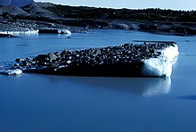
Dropstones are isolated fragments of rock found within finer-grained water-deposited sedimentary rocks or pyroclastic beds. They range in size from small pebbles to boulders. The critical distinguishing feature is that there is evidence that they were not transported by normal water currents, but rather dropped in vertically through the air or water column. Such depositions can occur during a volcanic eruption, e.g.
Fluvioglacial landforms or glaciofluvial landforms are those that result from the associated erosion and deposition of sediments caused by glacial meltwater. Glaciers contain suspended sediment loads, much of which is initially picked up from the underlying landmass. Landforms are shaped by glacial erosion through processes such as glacial quarrying, abrasion, and meltwater. Glacial meltwater contributes to the erosion of bedrock through both mechanical and chemical processes. Fluvio-glacial processes can occur on the surface and within the glacier. The deposits that happen within the glacier are revealed after the entire glacier melts or partially retreats. Fluvio-glacial landforms and erosional surfaces include: outwash plains, kames, kame terraces, kettle holes, eskers, varves, and proglacial lakes.

Marine sediment, or ocean sediment, or seafloor sediment, are deposits of insoluble particles that have accumulated on the seafloor. These particles either have their origins in soil and rocks and have been transported from the land to the sea, mainly by rivers but also by dust carried by wind and by the flow of glaciers into the sea, or they are biogenic deposits from marine organisms or from chemical precipitation in seawater, as well as from underwater volcanoes and meteorite debris.

Submarine landslides are marine landslides that transport sediment across the continental shelf and into the deep ocean. A submarine landslide is initiated when the downwards driving stress exceeds the resisting stress of the seafloor slope material, causing movements along one or more concave to planar rupture surfaces. Submarine landslides take place in a variety of different settings, including planes as low as 1°, and can cause significant damage to both life and property. Recent advances have been made in understanding the nature and processes of submarine landslides through the use of sidescan sonar and other seafloor mapping technology.

The Riiser-Larsen Sea is one of the marginal seas located in the Southern Ocean off East Antarctica and south of the Indian Ocean. It is delimited Astrid Ridge in the west and the Gunnerus Ridge and the Kainanmaru Bank in the east. It is bordered by the Lazarev Sea to the west and the Cosmonauts Sea to the east, or between 14°E and 30°E. Its northern border is defined to be the 65th parallel south. The name, proposed by the Soviet Union, was never officially approved by the International Hydrographic Organization (IHO).

Meltwater pulse 1B (MWP1b) is the name used by Quaternary geologists, paleoclimatologists, and oceanographers for a period of either rapid or just accelerated post-glacial sea level rise that some hypothesize to have occurred between 11,500 and 11,200 calendar years ago at the beginning of the Holocene and after the end of the Younger Dryas. Meltwater pulse 1B is also known as catastrophic rise event 2 (CRE2) in the Caribbean Sea.