
The Rideau River is a river in Eastern Ontario, Canada. The river flows north from Upper Rideau Lake and empties into the Ottawa River at the Rideau Falls in Ottawa, Ontario. Its length is 146 kilometres (91 mi).

The Rideau Canal, also known unofficially as the Rideau Waterway, connects Canada's capital city of Ottawa, Ontario, to Lake Ontario and the Saint Lawrence River at Kingston. It is 202 kilometres long. The name Rideau, French for "curtain", is derived from the curtain-like appearance of the Rideau River's twin waterfalls where they join the Ottawa River. The canal system uses sections of two rivers, the Rideau and the Cataraqui, as well as several lakes. Parks Canada operates the Rideau Canal.

Eastern Ontario is a secondary region of Southern Ontario in the Canadian province of Ontario which lies in a wedge-shaped area between the Ottawa River and St. Lawrence River. It shares water boundaries with Quebec to the north and New York State to the east and south, as well as a small land boundary with the Vaudreuil-Soulanges region of Quebec to the east.
In shooter games, rocket jumping is the technique of using the knockback of an explosive weapon, most often a rocket launcher, to launch the shooter into the air. The aim of this technique is to reach heights and distances that standard character movement cannot achieve. Although the origin of rocket jumping is unclear, its usage was popularized by Quake.

Frazil ice is a collection of loose, randomly oriented ice crystals millimeter and sub-millimeter in size, with various shapes, e.g. elliptical disks, dendrites, needles and of an irregular nature. Frazil ice forms during the winter in open-water reaches of rivers as well as in lakes and reservoirs, where and when the water is in a turbulent state, which is, in turn, induced by the action of waves and currents. Turbulence causes the water column to become supercooled, as the heat exchange between the air and the water is such that the water temperature drops below its freezing point. The vertical mixing associated with that turbulence provides enough energy to overcome the crystals' buoyancy, thus keeping them from floating at the surface. Frazil ice also forms in oceans, where windy conditions, wave regimes and cold air also favor the establishment of a supercooled layer. Frazil ice can be found on the downwind side of leads, and in polynyas. In these environments, that ice can eventually accumulate at the water surface into what is referred to as grease ice.

The Peace–Athabasca Delta, located in northeast Alberta, is the largest freshwater inland river delta in North America. It is located partially within the southeast corner of Wood Buffalo National Park, Canada's largest national park, and also spreads into the Regional Municipality of Wood Buffalo, west and south of the historical community of Fort Chipewyan. The delta encompasses approximately 321,200 ha, formed where the Peace and Athabasca rivers converge on the Slave River and Lake Athabasca. The delta region is designated a wetland of international importance and a UNESCO World Heritage Site. The region is large enough that it is considered one of twenty distinct natural subregions of Alberta by the provincial government's Natural Regions Committee.
The Bytown and Prescott Railway (B&PR) was a railway joining Ottawa with Prescott on the Saint Lawrence River. The company was incorporated in 1850, and the first train ran from Prescott into Bytown on Christmas Day, 1854. The 84 km railway, Ottawa's first to outside markets, was initially used to ship lumber collected on the Ottawa River for further shipping along the St. Lawrence to markets in the United States and Montreal.

Blast fishing, fish bombing, dynamite fishing or grenade fishing is a destructive fishing practice using explosives to stun or kill schools of fish for easy collection. This often illegal practice is extremely destructive to the surrounding ecosystem, as the explosion often destroys the underlying habitat that supports the fish. The frequently improvised nature of the explosives used, and undetonated charges, means danger for fishermen and divers as well, with accidents and injuries.

The Hog's Back Falls, officially known as the Prince of Wales Falls, but rarely referred to by this name, are a series of artificial waterfalls on the Rideau River in Ottawa, Ontario, Canada. The falls are located just north of Mooney's Bay and the point where the Rideau Canal splits from the Rideau River.
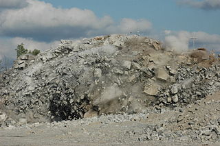
Drilling and blasting is the controlled use of explosives and other methods, such as gas pressure blasting pyrotechnics, to break rock for excavation. It is practiced most often in mining, quarrying and civil engineering such as dam, tunnel or road construction. The result of rock blasting is often known as a rock cut.

Anti-personnel mines are a form of mine designed for use against humans, as opposed to anti-tank mines, which are designed for use against vehicles. Anti-personnel mines may be classified into blast mines or fragmentation mines; the latter may or may not be a bounding mine.
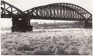
Ice jams occur when a topographic feature of the river causes floating river ice to accumulate and impede further progress downstream with the river current. Ice jams can significantly reduce the flow of a river and cause upstream flooding—sometimes called ice dams. Ice jam flooding can also occur downstream when the jam releases in an outburst flood. In either case, flooding can cause damage to structures on shore.
On May 29, 1929, a series of explosions in the sewers of Ottawa, Ontario, Canada, killed one person.
Westmeath Provincial Park is a provincial park on the Ottawa River in Renfrew County, Ontario, Canada. Located on the section of the river known as Bellows Bay, it features a long sandy beach and an active sandspit. It is one of the most pristine sand dune and wetland complexes along the southern Ottawa River.

The Rideau Skating Rink was an indoor skating and curling facility located in Ottawa, Ontario, Canada. Consisting of a curling rink and a skating rink, it was one of the first indoor rinks in Canada. The Rideau Rink was scheduled to open on January 10, 1889, but unseasonably mild weather postponed the grand opening to February 1. It opened on January 25, 1889 for select V.I.P.s although this was a misunderstanding and should not have denied entry to season ticket holders. It was located on Theodore Street, at Waller Street, at the present location of the Arts Hall of the University of Ottawa, near the Rideau Canal.

The Arena, also known as Dey's Arena was an arena for ice hockey located in Ottawa, Ontario, Canada. It was the home of the Ottawa Hockey Club from 1908 to 1923. It was the third in a series of ice hockey venues built by the Dey family of Ottawa. At the time of its building, it was Canada's largest arena.

A river is a natural flowing watercourse, usually freshwater, flowing towards an ocean, sea, lake or another river. In some cases, a river flows into the ground and becomes dry at the end of its course without reaching another body of water. Small rivers can be referred to using names such as creek, brook, rivulet, and rill. There are no official definitions for the generic term river as applied to geographic features, although in some countries or communities a stream is defined by its size. Many names for small rivers are specific to geographic location; examples are "run" in some parts of the United States, "burn" in Scotland and northeast England, and "beck" in northern England. Sometimes a river is defined as being larger than a creek, but not always: the language is vague.

The 2009 Red River flood along the Red River of the North in North Dakota and Minnesota in the United States and Manitoba in Canada brought record flood levels to the Fargo-Moorhead area. The flood was a result of saturated and frozen ground, spring snowmelt exacerbated by additional rain and snow storms, and virtually flat terrain. Communities along the Red River prepared for more than a week as the U.S. National Weather Service continuously updated the predictions for the city of Fargo, North Dakota, with an increasingly higher projected river crest. Originally predicted to reach a level of near 43 feet (13 m) at Fargo by March 29, the river in fact crested at 40.84 feet (12.45 m) at 12:15 a.m. March 28, and started a slow decline. The river continued to rise to the north as the crest moved downstream.

A river icebreaker is an icebreaker specially designed to operate in shallow waters such as rivers and estuaries, and often able to pass through canals and under bridges. As published by the American Society of Civil Engineers almost a century ago, "On some rivers, particularly where melting first takes place on the upper river, as on the Oder and Weichsel in Germany, the formation of ice jams is a frequent cause of floods." River icebreakers can operate in any navigable waterway to prevent such ice jams.

Sawmill Creek is a creek located in Ottawa, Ontario, Canada. It is a tributary of the Rideau River. It rises in the wetlands south and southwest of the community of Blossom Park in the Ottawa Greenbelt, specifically south of Lester Road. It flows roughly north by northwest through Blossom Park, and the neighbourhood of South Keys, through the McCarthy Woods, and then separates the neighbourhood of Riverside Park on the west from the neighbourhoods of Ellwood and Heron Park on the east, before entering the Rideau River at Billings Bridge, near the intersection of Bank Street and Riverside Drive.

