
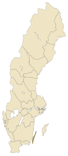
Kalmar County is a county or län in southern Sweden. It borders the counties of Kronoberg, Jönköping, Blekinge and Östergötland. To the east in the Baltic Sea is the island Gotland.
Hisingen is the fifth-largest island of Sweden, with an area of 199 km2 (77 sq mi). It forms part of Gothenburg and is bordered by the Göta älv to the south and east, the Nordre älv to the north, and the Kattegat to the west. The northern part of the city of Gothenburg, with its harbours, industries and suburbs, is located on the island, which is divided between the two historical provinces of Västergötland and Bohuslän.
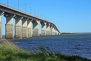
Öland is the second-largest Swedish island and the smallest of the traditional provinces of Sweden. Öland has an area of 1,342 square kilometres and is located in the Baltic Sea just off the coast of Småland. The island has 26,000 inhabitants. It is separated from the mainland by the Kalmar Strait and connected to it by the 6-kilometre Öland Bridge, which opened on 30 September 1972.

Life in the Freezer is a BBC nature documentary series written and presented by David Attenborough, first transmitted in the United Kingdom from 18 November 1993.

The Frisian Islands, also known as the Wadden Islands or the Wadden Sea Islands, form an archipelago at the eastern edge of the North Sea in northwestern Europe, stretching from the northwest of the Netherlands through Germany to the west of Denmark. The islands shield the mudflat region of the Wadden Sea from the North Sea.

The Öland Bridge is a road bridge connecting Kalmar on mainland Sweden to Färjestaden on the island of Öland to its east. At 6,072 meters (19,921 ft) long, it is one of the longest in all of Europe. It is supported by 156 pillars, and has a characteristic hump at its western end which was created to provide a vertical clearance of 36 m for shipping.

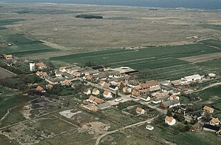
Mörbylånga is a locality situated on the southern part of the island of Öland and is the seat of Mörbylånga Municipality, Kalmar County, Sweden with 1,780 inhabitants in 2010.
Jeløya is an island located in the municipality of Moss in Østfold County, Norway.
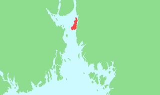
The Kalmar Strait is a strait in the Baltic Sea, located between the Swedish island of Öland and the province of Småland of the Swedish mainland. The strait is about 130 kilometres (81 mi) long and between 5 kilometres (3.1 mi) and 25 kilometres (16 mi) in width.
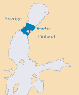
Kvarken is the narrow region of the Gulf of Bothnia separating the Bothnian Bay from the Bothnian Sea. The distance from the Swedish mainland to the Finnish mainland is around 80 km (50 mi), while the distance between the outermost islands is only 25 km (16 mi). The water depth in the Kvarken region is only around 25 metres (82 ft). The region also has an unusual rate of land rising at almost 10 mm a year.

Stora Alvaret is an alvar, a barren limestone terrace, in the southern half of the island of Öland, Sweden. Stora Alvaret is a dagger shaped expanse almost 40 kilometres (25 mi) long and about 10 kilometres (6 mi) at the widest north end. The area of this formation exceeds 260 square kilometres (100 sq mi), making it the largest such expanse in Europe and comprising over one fourth of the land area of the island.

Alby is a village on the Baltic Sea in the Hulterstad district at the western fringe of the Stora Alvaret on the island of Öland, Sweden.
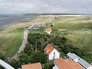
Ottenby is a town on the island of Öland, Sweden, located in Ås parish, Mörbylånga Municipality in Kalmar County. Ottenby is located just north of the southern tip of Öland, over three miles south of the area's main town, Mörbylånga. Ottenby is also the name of the mansion and a royal demesne, now a nature reserve.

Gettlinge is a village in the southwest portion of the island of Öland, Sweden. It is known for its impressive Viking stone ship burial ground. Gettlinge is situated on the western fringe of the Stora Alvaret, a World Heritage Site designated by UNESCO. The site is readily visible from the perimeter highway, Route 136. Gettlinge, as most prehistoric burial sites on Öland, is established on the low-lying ridge, described by Hogan as a geological formation of thickened soil in this alvar region of otherwise extremely thin soil mantle. This ridge was one of the few places on the southern part of the island that had sufficient soil depth for creation of burial mounds.
Hulterstad is a small coastal town on the southeastern part of the island of Öland, Sweden. Hulterstad is situated at the eastern fringe of the Stora Alvaret, a limestone pavement habitat which hosts a diversity of rare plants and has been designated a World Heritage Site by UNESCO. Hulterstad is the municipal government center for this district and central records for centuries were kept at the Hulterstad Church. Significant gravefields and a Viking stone burial ship structure are located immediately south of Hulterstad. To the north is located the village of Alby, where a mesolithic village of early human settlement has been found, and to the south is the Ottenby Nature Reserve. Across the alvar to the west is the village of Gettlinge.

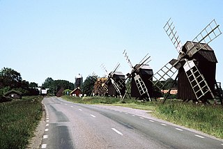
Swedish county road 136 is a county road on the island of Öland, Sweden. This facility is a paved two lane structure that runs along the west coast of the island from Ottenby in the south to Nabbelund in the north. This highway constitutes the majority of named highway coverage on the island. Route 136 connects to Route 137 somewhat east of the Öland bridge, which crosses the Kalmar Strait. Much of the island of Öland has been designated a world heritage site by UNESCO in the form of the Stora Alvaret nature reserve. This reserve is home to a vast number of rare and endangered species due to the presence of an enormous limestone barren, which is the largest such formation in Europe. Route 136 is virtually the only spinal link allowing vehicle access to all parts of the Stora Alvaret.
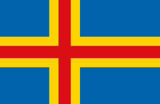
The Åland Islands, or simply Åland, is an archipelago at the entrance to the Gulf of Bothnia in the Baltic Sea belonging to Finland. It is an autonomous and demilitarised region of Finland since 1920 by a decision of the League of Nations, and its only official language is Swedish. It is the smallest region of Finland, constituting 0.51% of its land area and 0.54% of its population. Mariehamn is the capital city of Åland.

Småland is a historical province (landskap) in southern Sweden. Småland borders Blekinge, Scania, Halland, Västergötland, Östergötland and the island Öland in the Baltic Sea. The name Småland literally means Small Lands. The Latinized form Smolandia has been used in other languages. The highest point in Småland is Tomtabacken, at 377 metres (1,237 ft). In terms of total area, Småland is of a similar size as Belgium.
Events from the year 1972 in Sweden
The agricultural landscape of southern Öland is an area of more than 56,000 hectares located on the island of Öland, Sweden. It includes Stora alvaret, a limestone plateau of around half that surface. Stora alvaret is a dagger-shaped area almost 40 km (25 mi) long and about 10 km (6.2 mi) at its widest north end. This limestone plain, around a quarter of the surface of the island, is the most extended of its kind in Europe. As a result of the thin layer of soil and high pH levels, it presents a wide range of plants, including many rare species.

