Ice pier

Last updated
Severe cracks in an ice pier in use for four seasons at McMurdo Station slowed cargo operations in 1983 and proved to be a safety hazard. USNS Southern Cross at the ice pier in 1983.jpg
Severe cracks in an ice pier in use for four seasons at McMurdo Station slowed cargo operations in 1983 and proved to be a safety hazard.

An ice pier or ice wharf is a man-made structure used to assist the unloading of ships in Antarctica. It is constructed by pumping seawater into a contained area and allowing the water to freeze. By repeating this procedure several times, additional layers are built up. The final structure is many metres in thickness, and strong enough to support container trucks. Operation Deep Freeze personnel constructed the first floating ice pier at Antarctica’s southernmost sea port [1] at McMurdo Station in 1973. [2] [3] [4] Ice piers have been in use each summer season since, at McMurdo's natural harbor at Winter Quarters Bay located at 77°50′S166°40′E / 77.833°S 166.667°E / -77.833; 166.667 . The harbor is positioned on the southern tip of Ross Island.

Contents

Historically, two supply ships, a freighter and a tanker, arrive at the ice pier each summer, after an icebreaker opens a ship channel through pack ice. The ice pier's key function is to provide a platform for freight trucks to come alongside a supply ship to receive or offload cargo. Steel cables attached to shoreline hold the dock in a fixed position.

Port officials distribute freight arriving at the dock to McMurdo Station, nearby Scott Base, and to field camps as far away as the South Pole. Imports include virtually any materials needed to support personnel living and working in Antarctica. Exports range from items such as scientific ice core samples and human waste collected from field camps to broken equipment and recyclables for return to the United States for processing.

Ice piers typically have a lifespan of three to five years. Once an ice pier is no longer usable, icebreakers tow the pier to sea to be cast adrift.

Annual break-in opens ship channel

Ships docking at the McMurdo Station ice pier rely upon icebreakers opening a ship channel from Upper McMurdo Sound to Winter Quarters Bay. One or more icebreakers, depending upon seasonal conditions, will typically open a channel from eight to 50 miles (80 km) long. [5]

However, in 2005 icebreakers encountered more than 90 miles (140 km) of pack ice blocking entry to McMurdo Sound. [6] The ice buildup occurred when a 100-mile-long iceberg (B15A) ran aground near Upper McMurdo Sound. Two icebreakers eventually broke a ship channel through to Winter Quarters Bay.

The ship channel provides a seaway for the few annual re-supply vessels and research ships which call upon the extraordinarily remote seaport at McMurdo Station. Preparation for the supply ships’ arrival includes icebreakers maintaining a uniform edge on the seaward side of the pier. The ship's skipper maneuvers the icebreaker to use its bow as a giant battering ram to scarf or shave jagged edges from the pier to facilitate ships tying up at the dock. [2]

Ice pier expedites shipping

U.S. ships discharged cargo at temporary iceports in McMurdo Sound prior to the military's invention of the ice pier. Ships during that time moored alongside seasonal pack ice where military longshoremen offloaded cargo onto large snow sleds. Equipment operators then used snow cats and tractors to tow the freight over ice to McMurdo, a difficult and potentially dangerous operation. Tankers arriving with oil, diesel fuel, and gasoline were forced to dock as far away as ten miles (16 km) from the harbour and pump their fuel ashore. [7]

Beginning in 1964, icebreakers started opening a ship channel to Winter Quarters Bay where ships tied off to fast ice, a form of sea ice attached to the coast or ice wall such as Antarctica's Ross Ice Shelf. However, mooring to fast ice produced undesirable results. Warm water discharged from ships eroded ice at the rate of some three square kilometres every year. [2]

Consequently, port authorities built a steel dock in 1972, which waves from a storm destroyed soon after. Builders came up with an alternative that same season. They constructed a block of ice, covered it with matting and straw and used it as a fender for a tanker that docked at the harbor in fall 1973. The ice fender became the forerunner to the contemporary ice pier. [8]

McMurdo's dock is not without comparison. In 1987 workers constructed a similar pier in Mys Shmidta, a small seaport located in Chukotka, a far-eastern territory adjacent to Alaska on the Arctic Sea. [9] And, like McMurdo, the Arctic ice pier facilitated getting ships to get closer to shore for loading cargo. The pier built in the former Soviet Union measured more than 700 metres long.

Seawater construction

Ice piers at McMurdo Station have been used since 1973 to support cargo operations such as shown here in 2006 with the M/V American Tern. MV American Tern (T-AK-4729) 200601.jpg
Ice piers at McMurdo Station have been used since 1973 to support cargo operations such as shown here in 2006 with the M/V American Tern.

The ice piers deployed at McMurdo Station have grown in sophistication and size since the ice fender prototype. A contemporary pier is approximately 800 feet (244 m) long by 300 feet (90 m) wide and 22 feet (6.7 m) thick. [10] Fleet operations personnel make the floating pier during the winter. They build upon naturally occurring frozen seawater in McMurdo Sound after the pack ice reaches approximately 0.6 m (2 ft) in thickness. [11]

Subsequently, workers construct a snow berm to a depth of several feet along the perimeter of the soon-to-be ice pier. High-volume pumps then flood the pack ice with seawater to a depth of about 10 cm (4 in). The seawater typically freezes solid within 24 hours. Personnel repeat the flooding until they achieve a thickness of 1.5 m (5 ft).

Next a reinforcement mat of approximately 2,100 m (6,900 ft) of 1” (25mm) steel cable is secured to 2” (50mm) steel pipe embedded in the ice pier. The pier overall requires approximately 6,300 m (21,000 ft) of steel cable for construction, according to National Science Foundation permit documentation.

Workers repeat the entire process three more times until the ice pier is approximately 6.7 m (22 ft) thick. Wooden utility poles drilled about four deep into the final ice pier support electrical and telephone service to the pier. Moreover, during the final construction phase, personnel mount shorter poles in the ice edge to serve as bollards to secure the pier to the shore at McMurdo. A 15–20 cm (6–8 in) layer of volcanic gravel tops off the pier to provide a non-slip surface and to insulate the ice from the summer sun.

Experience has shown that ice piers have a lifespan of three to five years. Factors such as stress cracking and erosion shorten the duration. In addition, storm surges, wave action, contact with vessels, and the warm water discharge from ships contribute to degradation of the pier's seaward edge.

Ice pier limits discovered

Cargo operations at McMurdo's ice pier in February 1983 involved a race against time before the breakup of the entire dock. Truck falling through the ice pier in 1983.jpg
Cargo operations at McMurdo's ice pier in February 1983 involved a race against time before the breakup of the entire dock.

Ice pier operations at the world's most southern port have not been without mishap. The principal threat is onshore winds with accompanying high seas and ocean swells, which can severely damage the ice pier. For example, in 1993, high winds and heavy swells caused major cracks in the wharf. Rough seas produced movements of several feet between individual sections of the pier, according to a National Science Foundation (NSF) report. [12] The resulting damage prevented vehicles from traveling onto the pier for repairs.

Conditions worsened the following week when additional storms pushed ice, slush, and sea water onto the pier, flooding about one-half of the dock. The inundation on the pier's seaward side reached three to six-feet high and froze nearly immediately, according to the NSF report. The strategy to repair the storm damage included adding additional restraining cables followed by routine flooding to build up the ice thickness.

Notable incidents with damaged ice piers at McMurdo Station include an event 10 years earlier. The ice pier had been in use four seasons in 1983 when the freighter USNS Southern Cross docked at Winter Quarters Bay. Operation Deep Freeze officials pressed the pier into extended service in order for the freighter to make an unprecedented two supply runs in one season from Port Lyttelton, New Zealand, to McMurdo. [13] However, efforts to extend the ice pier's lifespan resulted in a cargo truck breaking through the ice. The driver of the truck standing atop the container leapt to safety, receiving minor injuries.

The most recent incident in 2010 occurred when a 10-year storm blew in causing white cap waves to wash the pier out to sea. It was assumed to be lost with the Jamesway hut, telephone pole, bollards, and other equipment still on it. Found during the austral summer in 2011, the equipment was ferried by helicopter back to McMurdo. A tracking beacon was left on the Ice Pier as it drifted out to sea. [14]

Maintenance gives way to disposal

Maintenance on the ice pier begins at the end of the austral summer. Equipment operators remove the gravel and store it for the next season. Removing the gravel prevents the gravel's insulating qualities from inhibiting further thickening of the ice during winter. Winter operations include plowing insulating snow from the dock and flooding the pier with seawater to help sustain the ice strength.

However, when the pier is no longer usable, a permit from the Antarctic Conservation Act allows for an icebreaker to tow the ice pier out to McMurdo Sound and cast it adrift. Preparations for dumping include:

After release at sea, currents and southerly winds drive the ice pier north towards the Ross Sea and into the circumpolar currents of the Southern Ocean. A beacon mounted on the pier allows for tracking and serves as a warning to ships. The pier mixes with pack ice and eventually melts, a process that can take years, according to NSF estimates. Consequently, some 21,000 feet (6,400 m) of 1-inch (25 mm) steel cable and 650 feet (200 m) of 2-inch (51 mm) pipe used in its construction sink to the ocean floor [15]

U.S. government reports vary regarding the fate of the untreated wooden bollards used in the ice pier. The wood in some instances is reported as weighted so as to sink. Yet a 1999 ocean dumping permit notes that: "the short lengths of wooden poles will float in the ocean for several months before becoming waterlogged and eventually sinking to the ocean floor."

See also

Notes

  1. U.S. Polar Programs National Science Foundation FY2000.
  2. 1 2 3 "Unique ice pier provides harbor for ships," Antarctic Sun. January 8, 2006; McMurdo Station, Antarctica.
  3. COLD Database: Antarctic Journal of the United States, Vol. 8 No. 4 p. 220 "Ship Operations, Deep Freeze 73" (July-August 1973) and Vol. 9 No. 4 p. 180 "Ship Operations, Deep Freeze 74" (July-August 1974).
  4. "The "Bunyon Watch"", Sealift: Magazine of USN Military Sealift Command, Vol. 24, No. 4, p. 16 (April 1974).
  5. “Polar Star Duties,” Seattle Post-Intelligencer. December 1999.
  6. "U.S., Russian icebreakers open path to Antarctic base," USA Today. February 6, 2005
  7. Clarke, Peter; On the Ice. Rand McNally & Company, 1966.
  8. “Ice pier serves as bridge to supplies,” Archived 2007-09-30 at the Wayback Machine Antarctic Sun. January 11, 2004. McMurdo Station, Antarctica.
  9. "Ice floe used as pier," The USSR Weekly Economic Report. British Broadcasting Corporation citing Soviet television. October 16, 1987.
  10. “Issuance of a Final General Permit to the National Science Foundation for the Ocean Disposal of Man-Made Ice Piers From its Base at McMurdo Sound on Antarctica,” Federal Register. February 14, 2003 (Volume 68, Number 31).
  11. “Issuance of a General Permit to the National Science Foundation for the Ocean Disposal of Man-Made Ice Piers From its Base at McMurdo Sound on Antarctica,” Federal Register. January 7, 2003 (Volume 68, Number 4)
  12. "Damage to McMurdo ice pier," National Science Foundation Office of Polar Programs. July 14, 1993.
  13. "Race to reach McMurdo Station," The Press, March 23, 1983. Christchurch, New Zealand.
  14. "Without pier," Antarctic Sun. December 2, 2011; McMurdo Station, Antarctica.
  15. Issuance of an Emergency Ocean Dumping Permit to the National Science Foundation for Disposal of an Ice Pier From Its Base at McMurdo Station, Antarctica, Federal Registry Environmental Documents. February 5, 1999.

Related Research Articles

Transport in Antarctica has transformed from explorers crossing the isolated remote area of Antarctica by foot to a more open era due to human technologies enabling more convenient and faster transport, predominantly by air and water, as well as land. Transportation technologies on a remote area like Antarctica need to be able to deal with extremely low temperatures and continuous winds to ensure the travelers' safety. Due to the fragility of the Antarctic environment, only a limited amount of transport movements can take place and sustainable transportation technologies have to be used to reduce the ecological footprint. The infrastructure of land, water and air transport needs to be safe and sustainable. Currently thousands of tourists and hundreds of scientists a year depend on the Antarctic transportation system.

McMurdo Station American Antarctic base

The McMurdo Station is a United States Antarctic research station on the south tip of Ross Island, which is in the New Zealand–claimed Ross Dependency on the shore of McMurdo Sound in Antarctica. It is operated by the United States through the United States Antarctic Program, a branch of the National Science Foundation. The station is the largest community in Antarctica, capable of supporting up to 1,258 residents, and serves as one of three year-round United States Antarctic science facilities. All personnel and cargo going to or coming from Amundsen–Scott South Pole Station first pass through McMurdo. By road, McMurdo is 3 kilometres (1.9 mi) from New Zealand's smaller Scott Base.

RRS <i>Discovery</i> Barque museum ship

The RRS Discovery was a barque-rigged auxiliary steamship built for Antarctic research. Launched in 1901, she was the last traditional wooden three-masted ship to be built in the United Kingdom. Her first mission was the British National Antarctic Expedition, carrying Robert Falcon Scott and Ernest Shackleton on their first, and highly successful, journey to the Antarctic, known as the Discovery Expedition.

Palmer Station Antarctic base

Palmer Station is a United States research station in Antarctica located on Anvers Island, the only US station located north of the Antarctic Circle. Initial construction of the station finished in 1968. The station, like the other U.S. Antarctic stations, is operated by the United States Antarctic Program (USAP) of the National Science Foundation. The base is about as distant from the equator as Fairbanks, Alaska.

Drift ice Sea ice that is not attached to land

Drift ice, also called brash ice, is sea ice that is not attached to the shoreline or any other fixed object. Unlike fast ice, which is "fastened" to a fixed object, drift ice is carried along by winds and sea currents, hence its name. When drift ice is driven together into a large single mass, it is called pack ice. Wind and currents can pile up that ice to form ridges up to tens of metres in thickness. These represent a challenge for icebreakers and offshore structures operating in cold oceans and seas.

McMurdo Sound

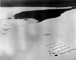
McMurdo Sound and its ice-clogged waters extends about 55 kilometres (34 mi) long and wide. The sound connects the Ross Sea to the north with the Ross Ice Shelf cavity to the south via Haskell Strait. The strait is largely covered by the McMurdo Ice Shelf. The Royal Society Range rises from sea level to 4,205 metres (13,796 ft) on the western shoreline. Ross Island, an historic jumping-off point for polar explorers, designates the eastern boundary. The active volcano Mount Erebus at 3,794 metres (12,448 ft) dominates Ross Island. Antarctica's largest scientific base, the United States' McMurdo Station, as well as the New Zealand Scott Base are on the southern shore of the island. Less than 10 percent of McMurdo Sound's shoreline is free of ice. It is the southernmost navigable body of water in the world.

Little America (exploration base) Antarctic camp

Little America was a series of Antarctic exploration bases from 1929 to 1958, located on the Ross Ice Shelf, south of the Bay of Whales.

United States Antarctic Program U.S. Government agency which maintains U.S. presence and research in Antarctica

The United States Antarctic Program is an organization of the United States government which has presence in the Antarctica continent. Founded in 1959, the USAP manages all U.S. scientific research and related logistics in Antarctica as well as aboard ships in the Southern Ocean.

<i>Krasin</i> (1976 icebreaker)

The Krasin is a Russian icebreaker. The vessel operates in polar regions.

USCGC <i>Polar Star</i> (WAGB-10)

USCGC Polar Star (WAGB-10) is a United States Coast Guard heavy icebreaker. Commissioned in 1976, the ship was built by Lockheed Shipbuilding and Construction Company of Seattle, Washington along with sister ship, USCGC Polar Sea.

Operation Deep Freeze is codename for a series of United States missions to Antarctica, beginning with "Operation Deep Freeze I" in 1955–56, followed by "Operation Deep Freeze II", "Operation Deep Freeze III", and so on.. Given the continuing and constant US presence in Antarctica since that date, "Operation Deep Freeze" has come to be used as a general term for US operations in that continent, and in particular for the regular missions to resupply US Antarctic bases, coordinated by the United States military.

USS Glacier (AGB-4) was a U.S. Navy, then U.S. Coast Guard icebreaker which served in the first through fifteenth Operation Deep Freeze expeditions. Glacier was first icebreaker to make her way through the frozen Bellingshausen Sea, and most of the topography in the area is named for her crew members. When built, Glacier had the largest capacity single armature DC motors ever installed on a ship. Glacier was capable of breaking ice up to 20 feet (6.1 m) thick, and of continuous breaking of 4-foot (1.2 m) thick ice at 3 knots.

Observation Hill (McMurdo Station)

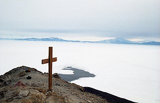
Observation Hill is a steep 754-foot (230 m) hill adjacent to McMurdo Station in Antarctica and commonly called "Ob Hill." It is frequently climbed to get good viewing points across the continent. Regular clear skies give excellent visibility.

USCGC <i>Burton Island</i> (WAGB-283)

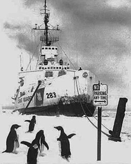
USS Burton Island (AG-88) was a United States Navy Wind-class icebreaker that was later recommissioned in the United States Coast Guard as the USCGC Burton Island (WAGB-283). She was named after an island near the coast of Delaware.

USS <i>Arneb</i>

USS Arneb (AKA-56/LKA-56) was an Andromeda-class attack cargo ship named after Arneb, the brightest star in the southern constellation Lepus. She served as a commissioned ship for 27 years and 3 months, the longest time in commission of any AKA.

USCGC <i>Staten Island</i> (WAGB-278)

USCGC Staten Island (WAGB-278) was a United States Coast Guard Wind-class icebreaker. Laid down on 9 June 1942 and launched on 28 December 1942, the ship was commissioned on 26 February 1944, and almost immediately afterward transferred to the Soviet Union, under the Lend Lease program, under the name Severny Veter, which loosely translates as Northwind, until 19 December 1951. When returned to the United States Navy, she was designated USS Northwind until 15 April 1952, when she was renamed Staten Island to distinguish her from her successor USCGC Northwind (WAGB-282) which had been laid down shortly after she was lent to the Soviet Union. The ship was transferred to the U.S. Coast Guard as USCGC Staten Island in February 1965, and served until November 1974, before being scrapped.

Marble Point Antarctic base in the United States

Marble Point is a rocky promontory on the coast of Victoria Land, Antarctica, located at 77° 26' S latitude and 163° 50' E longitude. The United States operates a station at the point. The outpost is used as a helicopter refueling station supporting scientific research in the nearby continental interior such as the McMurdo Dry Valleys. Weather permitting, helicopters are able to fly in and out of the station 24 hours a day during the summer research season.

Winter Quarters Bay

Winter Quarters Bay is a small cove of McMurdo Sound, Antarctica, located 2,200 miles (3,500 km) due south of New Zealand at 77°50'S. The harbor is the southernmost port in the Southern Ocean and features a floating ice pier for summer cargo operations. The bay is approximately 250m wide and long, with a maximum depth of 33m. The name Winter Quarters Bay refers to Robert Falcon Scott's National Antarctic Discovery Expedition (1901–04) which wintered at the site for two seasons.

Iceport

An iceport is a more-or-less permanent indentation in the front of an ice shelf, that can serve as a natural ice harbour. Though useful, they are not always reliable, as calving of surrounding ice shelves can render an iceport temporarily unstable and unusable.

Ellsworth Station Antarctic base

Ellsworth Scientific Station was a permanent, all year-round originally American, then Argentine Antarctic scientific research station named after American polar explorer Lincoln Ellsworth. It was located on Gould Bay, on the Filchner Ice Shelf.

References

Coordinates: 77°50′S166°40′E / 77.833°S 166.667°E / -77.833; 166.667