Glacial erratic

Last updated
Glacial erratics from Norway on Schokland in the Netherlands Schokland, zwerfsteen bij ingang museum-restaurant foto6 2013-04-28 13.02.jpg
Glacial erratics from Norway on Schokland in the Netherlands
Glacial erratic boulder in Snowdonia (Eryri), Wales Large glacial erratic (boulder), covered in lichen, on the slopes of Moel-y-Ci.jpg
Glacial erratic boulder in Snowdonia (Eryri), Wales

A glacial erratic is a glacially deposited rock differing from the type of rock native to the area in which it rests. Erratics, which take their name from the Latin word errare ("to wander"), are carried by glacial ice, often over distances of hundreds of kilometres. Erratics can range in size from pebbles to large boulders such as Big Rock (16,500 tonnes or 18,200 short tons) in Alberta.

Contents

Geologists identify erratics by studying the rocks surrounding the position of the erratic and the composition of the erratic itself. Erratics are significant because:

Formation of erratics

Multiple erratics on the terminal moraine of the Okanogan Lobe. The Cascade Mountains are in the background. Erratics-Cascades-PB110028.JPG
Multiple erratics on the terminal moraine of the Okanogan Lobe. The Cascade Mountains are in the background.

The term "erratic" is commonly used to refer to erratic blocks, which geologist Archibald Geikie describes as: "large masses of rock, often as big as a house, that have been transported by glacier ice, and have been lodged in a prominent position in the glacier valleys or have been scattered over hills and plains. And examination of their mineralogical character leads the identification of their sources...". [2] In geology, an erratic is material moved by geologic forces from one location to another, usually by a glacier.

Erratics are formed by glacial ice erosion resulting from the movement of ice. Glaciers erode by multiple processes including:

Doane Rock, at Cape Cod National Seashore Doane Rock.jpeg
Doane Rock, at Cape Cod National Seashore

Evidence supports another possibility for the creation of erratics as well: rock avalanches onto the upper surface of the glacier (supraglacial). Rock avalanchesupraglacial transport occurs when the glacier undercuts a rock face, which fails by avalanche onto the upper surface of the glacier. The characteristics of rock avalanche–supraglacial transport includes: [5]

  • Monolithologic composition – a cluster of boulders of similar composition are frequently found in close proximity. Commingling of the multiple lithologies normally present throughout the glaciated basin, has not occurred. [5]
  • Angularity – the supraglacially transported rocks tend to be rough and irregular, with no sign of subglacial abrasion. The sides of boulders are roughly planar, suggesting that some surfaces may be original fracture planes. [5]
  • Great size – the size distribution of the boulders tends to be skewed toward larger boulders than those produced subglacially. [5]
  • Surficial positioning of the boulders – the boulders are positioned on the surface of glacial deposits, as opposed to partially or totally buried. [5]
  • Restricted areal extents – the boulder fields tend to have limited areal extent; the boulders cluster together, consistent with the boulders landing on the surface of the glacier and subsequently deposited on top of the glacial drift. [5]
  • Orientations – the boulders may be close enough that original fracture planes can be matched. [5]
  • Locations of the boulder trains – the boulders appear in rows, trains or clusters along the lateral moraines as opposed to being located on the terminal moraine or in the general glacial field. [5]

Glacier-borne erratic

Two small icebergs at right clearly retain fragments of the moraine (rock debris) that forms a dark line along the upper surface of the glacier. The inclusion of the moraine illustrates how land-based rocks and sediment are carried by ice. Upsala Glacier, Argentina.jpg
Two small icebergs at right clearly retain fragments of the moraine (rock debris) that forms a dark line along the upper surface of the glacier. The inclusion of the moraine illustrates how land-based rocks and sediment are carried by ice.

Erratics provide an important tool in characterizing the directions of glacier flows, which are routinely reconstructed used on a combination of moraines, eskers, drumlins, meltwater channels and similar data. Erratic distributions and glacial till properties allow for identification of the source rock from which they derive, which confirms the flow direction, particularly when the erratic source outcrop is unique to a limited locality. Erratic materials may be transported by multiple glacier flows prior to their deposition, which can complicate the reconstruction of the glacial flow. [6]

Ice-rafted erratic

Glacial ice entrains debris of varying sizes from small particles to extremely large masses of rock. This debris is transported to the coast by glacier ice and released during the production, drift and melting of icebergs. The rate of debris release by ice depends upon the size of the ice mass in which it is carried as well as the temperature of the ocean through which the ice floe passes. [7] [8]

Yeager Rock, a 400-metric-ton (440-short-ton) boulder on the Waterville Plateau, Washington. Although transported by a glacier, this boulder is not a true erratic because it is of the same lithology as the underlying, till-blanketed bedrock. Note the glacial till below the rock. Yeager-Rock-Erractic-PB110039.JPG
Yeager Rock, a 400-metric-ton (440-short-ton) boulder on the Waterville Plateau, Washington. Although transported by a glacier, this boulder is not a true erratic because it is of the same lithology as the underlying, till-blanketed bedrock. Note the glacial till below the rock.

Sediments from the late Pleistocene period lying on the floor of the North Atlantic show a series of layers (referred to as Heinrich layers) which contain ice-rafted debris. They were formed between 14,000 and 70,000 years before the present. The deposited debris can be traced back to the origin by both the nature of the materials released and the continuous path of debris release. Some paths extend more than 3,000 kilometres (1,900 mi) distant from the point at which the ice floes originally broke free. [7]

The location and altitude of ice-rafted boulders relative to the modern landscape has been used to identify the highest level of water in proglacial lakes (e.g. Lake Musselshell in central Montana) and temporary lakes (e.g. Lake Lewis in Washington state). Ice-rafted debris is deposited when the iceberg strands on the shore and subsequently melts, or drops out of the ice floe as it melts. Hence all erratic deposits are deposited below the actual high water level of the lake; however, the measured altitude of ice-rafted debris can be used to estimate the lake surface elevation.

Angular glacial erratic on Lembert Dome Angular glacial erratic on Lambert Dome-750px.jpg
Angular glacial erratic on Lembert Dome

This is accomplished by recognizing that on a fresh-water lake, the iceberg floats until the volume of its ice-rafted debris exceeds 5% of the volume of the iceberg. Therefore, a correlation between the iceberg size and the boulder size can be established. For example, a 1.5-metre-diameter (5 ft) boulder can be carried by a 3-metre-high (10 ft) iceberg and could be found stranded at higher elevations than a 2-metre (7 ft) boulder, which requires a 4-metre-high (13 ft) iceberg. [9]

Large erratics

Glacial erratic Ehalkivi with overground volume 930 cubic metres (1,220 cu yd) (weight approximately 2,500 metric tons or 2,800 short tons) in Estonia Letipea hiidrahn.jpg
Glacial erratic Ehalkivi with overground volume 930 cubic metres (1,220 cu yd) (weight approximately 2,500 metric tons or 2,800 short tons) in Estonia
Area exposed by the retreat of Alaska's Steller Glacier in August 1996, the westernmost part of Bering Glacier's piedmont lobe. The ground surface is covered by glacial sediment deposited as lodgement and ablation till. The erratic is an angular, 20-foot-high (6.1 m) piece of gneiss. Bering Glacier, Alaska flows through Wrangell-St. Elias National Park and Preserve. Glacial erratic in alaska.gif
Area exposed by the retreat of Alaska's Steller Glacier in August 1996, the westernmost part of Bering Glacier's piedmont lobe. The ground surface is covered by glacial sediment deposited as lodgement and ablation till. The erratic is an angular, 20-foot-high (6.1 m) piece of gneiss. Bering Glacier, Alaska flows through Wrangell–St. Elias National Park and Preserve.

Large erratics consisting of slabs of bedrock that have been lifted and transported by glacier ice to subsequently be stranded above thin glacial or fluvioglacial deposits are referred to as glacial floes, rafts (schollen) or erratic megablocks. Erratic megablocks have typical length to thickness ratios on the order of 100 to 1. These megablocks may be found partially exposed or completely buried by till and are clearly allochthonous, since they overlay glacial till. Megablocks can be so large that they are mistaken for bedrock until underlying glacial or fluvial sediments are identified by drilling or excavation. Such erratic megablocks greater than 1 square kilometre (250 acres) in area and 30 metres (98 ft) in thickness can be found on the Canadian Prairies, Poland, England, Denmark and Sweden. One erratic megablock located in Saskatchewan is 30 by 38 kilometres (19 mi × 24 mi) (and up to 100 metres or 330 feet thick). Their sources can be identified by locating the bedrock from which they were separated; several rafts from Poland and Alberta were determined to have been transported over 300 kilometres (190 mi) from their source. [10]

Nonglacial erratics

In geology an erratic is any material which is not native to the immediate locale but has been transported from elsewhere. The most common examples of erratics are associated with glacial transport, either by direct glacier-borne transport or by ice rafting. However, other erratics have been identified as the result of kelp holdfasts, which have been documented to transport rocks up to 40 centimetres (16 in) in diameter, rocks entangled in the roots of drifting logs, and even in transport of stones accumulated in the stomachs of pinnipeds during foraging. [11]

History

Erratic rocks on Estonian northern coast Erratic rocks of estonian northern coast.jpg
Erratic rocks on Estonian northern coast

During the 18th century, erratics were deemed a major geological paradox. Geologists identify erratics by studying the rocks surrounding the position of the erratic and the rock of the erratic itself. Erratics were once considered evidence of a biblical flood, [12] but in the 19th century scientists gradually came to accept that erratics pointed to an ice age in Earth's past. Among others, the Swiss politician, jurist and theologian Bernhard Friedrich Kuhn  [ de ] saw glaciers as a possible solution as early as 1788. However, the idea of ice ages and glaciation as a geological force took a while to be accepted. Ignaz Venetz (1788–1859), a Swiss engineer, naturalist and glaciologist was one of the first scientists to recognize glaciers as a major force in shaping the earth.

In the 19th century, many scientists came to favor erratics as evidence for the end of the Last Glacial Maximum (ice age) 10,000 years ago, rather than a flood. Geologists have suggested that landslides or rockfalls initially dropped the rocks on top of glacial ice. The glaciers continued to move, carrying the rocks with them. When the ice melted, the erratics were left in their present locations.

Charles Lyell's Principles of Geology (v. 1, 1830) [13] provided an early description of the erratic which is consistent with the modern understanding. Louis Agassiz was the first to scientifically propose that the Earth had been subject to a past ice age. [14] In the same year, he was elected a foreign member of the Royal Swedish Academy of Sciences. Prior to this proposal, Goethe, de Saussure, Venetz, Jean de Charpentier, Karl Friedrich Schimper and others had made the glaciers of the Alps the subjects of special study, and Goethe, [15] Charpentier as well as Schimper [14] had even arrived at the conclusion that the erratic blocks of alpine rocks scattered over the slopes and summits of the Jura Mountains had been moved there by glaciers.

Charles Darwin published extensively on geologic phenomena including the distribution of erratic boulders. In his accounts written during the voyage of HMS Beagle, Darwin observed a number of large erratic boulders of notable size south of the Strait of Magellan, Tierra del Fuego and attributed them to ice rafting from Antarctica. Recent research suggests that they are more likely the result of glacial ice flows carrying the boulders to their current locations. [16]

Examples

Glacier-borne erratics

Example of mixed erratics. The boulder in the foreground is basalt. The boulder on the other side of the fence is granite. Mixed-Eratics-PB110053.JPG
Example of mixed erratics. The boulder in the foreground is basalt. The boulder on the other side of the fence is granite.

Australia

Canada

Estonia

  • Ehalkivi (Sunset Glow Boulder) near Letipea, Estonia is the largest erratic boulder in the glaciation area of North Europe. Height 7 m, circumference 48.2 m, a volume of 930 m3 and a mass of approx 2,500 tonnes

Finland

Kukkarokivi in March 2013 Kukkarokivi 1.jpg
Kukkarokivi in March 2013

Germany

Republic of Ireland

Latvia

Laucu Stone in Vidzeme coastline, Latvia LaucuAkmens.jpg
Lauču Stone in Vidzeme coastline, Latvia

Lithuania

Devil Stone, Kashubia, Poland Pl-pomerania-lake-Kamienne.jpg
Devil Stone, Kashubia, Poland

Poland

United Kingdom

England
The Drake Stone near Harbottle, Northumberland, is the height of a double-decker bus. DrakeStone.jpg
The Drake Stone near Harbottle, Northumberland, is the height of a double-decker bus.
Scotland
  • Jim Crow Rock, glacial erratic in Hunters Quay, situated on the foreshore of the Firth of Clyde. The rock has been the subject of controversy because of an allegedly racist face painted on it.
Northern Ireland

United States

Bubble Rock, Acadia National Park, Maine A079, Acadia National Park, Maine, USA, balanced rock, 2002.jpg
Bubble Rock, Acadia National Park, Maine
The Glen Rock, in Glen Rock, New Jersey Glen Rock, NJ (557511189).jpg
The Glen Rock, in Glen Rock, New Jersey

Flood-borne erratics

If glacial ice is "rafted" by a flood such as that created when the ice dam broke during the Missoula floods, then the erratics are deposited where the ice finally releases its debris load. One of the more unusual examples is found far from its origin in Idaho at Erratic Rock State Natural Site just outside McMinnville, Oregon. The park includes a 40-short-ton (36 t) specimen, the largest erratic found in the Willamette Valley.

See also

Related Research Articles

<span class="mw-page-title-main">Glacier</span> Persistent body of ice that is moving under its own weight

A glacier is a persistent body of dense ice that is constantly moving under its own weight. A glacier forms where the accumulation of snow exceeds its ablation over many years, often centuries. It acquires distinguishing features, such as crevasses and seracs, as it slowly flows and deforms under stresses induced by its weight. As it moves, it abrades rock and debris from its substrate to create landforms such as cirques, moraines, or fjords. Although a glacier may flow into a body of water, it forms only on land and is distinct from the much thinner sea ice and lake ice that form on the surface of bodies of water.

<span class="mw-page-title-main">Ice age</span> Period of long-term reduction in temperature of Earths surface and atmosphere

An ice age is a long period of reduction in the temperature of Earth's surface and atmosphere, resulting in the presence or expansion of continental and polar ice sheets and alpine glaciers. Earth's climate alternates between ice ages, and greenhouse periods during which there are no glaciers on the planet. Earth is currently in the ice age called Quaternary glaciation. Individual pulses of cold climate within an ice age are termed glacial periods, and intermittent warm periods within an ice age are called interglacials or interstadials.

<span class="mw-page-title-main">Moraine</span> Glacially formed accumulation of debris

A moraine is any accumulation of unconsolidated debris, sometimes referred to as glacial till, that occurs in both currently and formerly glaciated regions, and that has been previously carried along by a glacier or ice sheet. It may consist of partly rounded particles ranging in size from boulders down to gravel and sand, in a groundmass of finely-divided clayey material sometimes called glacial flour. Lateral moraines are those formed at the side of the ice flow, and terminal moraines were formed at the foot, marking the maximum advance of the glacier. Other types of moraine include ground moraines and medial moraines.

<span class="mw-page-title-main">Till</span> Unsorted glacial sediment

Till or glacial till is unsorted glacial sediment.

<span class="mw-page-title-main">Jökulhlaup</span> Type of glacial outburst flood

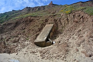
A jökulhlaup is a type of glacial outburst flood. It is an Icelandic term that has been adopted in glaciological terminology in many languages. It originally referred to the well-known subglacial outburst floods from Vatnajökull, Iceland, which are triggered by geothermal heating and occasionally by a volcanic subglacial eruption, but it is now used to describe any large and abrupt release of water from a subglacial or proglacial lake/reservoir.

<span class="mw-page-title-main">Cirque</span> An amphitheatre-like valley formed by glacial erosion

A cirque is an amphitheatre-like valley formed by glacial erosion. Alternative names for this landform are corrie and cwm. A cirque may also be a similarly shaped landform arising from fluvial erosion.

<span class="mw-page-title-main">Glacial landform</span> Landform created by the action of glaciers

Glacial landforms are landforms created by the action of glaciers. Most of today's glacial landforms were created by the movement of large ice sheets during the Quaternary glaciations. Some areas, like Fennoscandia and the southern Andes, have extensive occurrences of glacial landforms; other areas, such as the Sahara, display rare and very old fossil glacial landforms.

Parent material is the underlying geological material in which soil horizons form. Soils typically inherit a great deal of structure and minerals from their parent material, and, as such, are often classified based upon their contents of consolidated or unconsolidated mineral material that has undergone some degree of physical or chemical weathering and the mode by which the materials were most recently transported.

<span class="mw-page-title-main">Boulder clay</span> Geological deposit of clay

Boulder clay is an unsorted agglomeration of clastic sediment that is unstratified and structureless and contains gravel of various sizes, shapes, and compositions distributed at random in a fine-grained matrix. The fine-grained matrix consists of stiff, hard, pulverized clay or rock flour. Boulder clay is also known as drift clay; till; unstratified drift, Geschiebelehm (German); argile á blocaux (French); and keileem (Dutch).

<span class="mw-page-title-main">Plucking (glaciation)</span> Glacial erosion of bedrock

Plucking, also referred to as quarrying, is a glacial phenomenon that is responsible for the weathering and erosion of pieces of bedrock, especially large "joint blocks". This occurs in a type of glacier called a "valley glacier". As a glacier moves down a valley, friction causes the basal ice of the glacier to melt and infiltrate joints (cracks) in the bedrock. The freezing and thawing action of the ice enlarges, widens, or causes further cracks in the bedrock as it changes volume across the ice/water phase transition, gradually loosening the rock between the joints. This produces large chunks of rock called joint blocks. Eventually these joint blocks come loose and become trapped in the glacier.

<span class="mw-page-title-main">Tunnel valley</span> Glacial-formed geographic feature

A tunnel valley is a U-shaped valley originally cut under the glacial ice near the margin of continental ice sheets such as that now covering Antarctica and formerly covering portions of all continents during past glacial ages. They can be as large as 100 km (62 mi), 4 km (2.5 mi) wide, and 400 m (1,300 ft) deep.

<span class="mw-page-title-main">Abrasion (geology)</span> Process of erosion

Abrasion is a process of erosion that occurs when material being transported wears away at a surface over time, commonly happens in ice and glaciers. The primary process of abrasion is physical weathering. Its the process of friction caused by scuffing, scratching, wearing down, marring, and rubbing away of materials. The intensity of abrasion depends on the hardness, concentration, velocity and mass of the moving particles. Abrasion generally occurs in four ways: glaciation slowly grinds rocks picked up by ice against rock surfaces; solid objects transported in river channels make abrasive surface contact with the bed and walls; objects transported in waves breaking on coastlines; and by wind transporting sand or small stones against surface rocks. Abrasion is the natural scratching of bedrock by a continuous movement of snow or glacier downhill. This is caused by a force, friction, vibration, or internal deformation of the ice, and by sliding over the rocks and sediments at the base that causes the glacier to move.

<span class="mw-page-title-main">Dropstone</span> Rock fragments found within host rock

Dropstones are isolated fragments of rock found within finer-grained water-deposited sedimentary rocks or pyroclastic beds. They range in size from small pebbles to boulders. The critical distinguishing feature is that there is evidence that they were not transported by normal water currents, but rather dropped in vertically through the air or water column. Such depositions can occur during a volcanic eruption, e.g.

Fluvioglacial landforms or glaciofluvial landforms are those that result from the associated erosion and deposition of sediments caused by glacial meltwater. Glaciers contain suspended sediment loads, much of which is initially picked up from the underlying landmass. Landforms are shaped by glacial erosion through processes such as glacial quarrying, abrasion, and meltwater. Glacial meltwater contributes to the erosion of bedrock through both mechanical and chemical processes. Fluvio-glacial processes can occur on the surface and within the glacier. The deposits that happen within the glacier are revealed after the entire glacier melts or partially retreats. Fluvio-glacial landforms and erosional surfaces include: outwash plains, kames, kame terraces, kettle holes, eskers, varves, and proglacial lakes.

<span class="mw-page-title-main">Foothills Erratics Train</span>

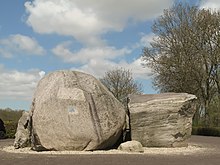
The Foothills Erratics Train is a 580 miles (930 km) long, narrow, linear scatter of thousands of typically angular boulders of distinctive quartzite and pebbly quartzite that lie on the surface of a generally north-south strip of the Canadian Prairies. These boulders, which are between 1 foot (0.30 m) and 135 feet (41 m) in length, are glacial erratics that lie upon a surficial blanket of Late Wisconsin glacial till. The largest glacial erratic within the Foothills Erratics Train is Big Rock.

<span class="mw-page-title-main">Boulder Park</span>

Boulder Park National Natural Landmark, of Douglas County, Washington, along with the nearby McNeil Canyon Haystack Rocks and Sims Corner Eskers and Kames natural landmarks, illustrate well-preserved examples of classic Pleistocene ice stagnation landforms that are found in Washington. These landforms include numerous glacial erratics and haystack rocks that occur near and on the Withrow Moraine, which is the terminal moraine of the Okanogan ice lobe.

<span class="mw-page-title-main">Balancing rock</span> Naturally occurring precariously balanced rock

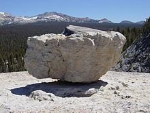
A balancing rock, also called a balanced rock or precarious boulder, is a naturally occurring geological formation featuring a large rock or boulder, sometimes of substantial size, resting on other rocks, bedrock, or on glacial till. Some formations known by this name only appear to be balancing, but are in fact firmly connected to a base rock by a pedestal or stem.

<span class="mw-page-title-main">Geology of New England</span> Overview of the geology of New England

New England is a region in the North Eastern United States consisting of the states Rhode Island, Connecticut, Massachusetts, New Hampshire, Vermont, and Maine. Most of New England consists geologically of volcanic island arcs that accreted onto the eastern edge of the Laurentian Craton in prehistoric times. Much of the bedrock found in New England is heavily metamorphosed due to the numerous mountain building events that occurred in the region. These events culminated in the formation of Pangaea; the coastline as it exists today was created by rifting during the Jurassic and Cretaceous periods. The most recent rock layers are glacial conglomerates.

<span class="mw-page-title-main">Glacial erratics on and around Rügen</span>

This is a list of erratics on and around Rügen – the largest island off the Baltic coast of Germany. An erratic is usually defined as an individual block of rock lying on the surface of the land which has a volume of at least one cubic metre and which was transported by a glacier to its present site during the ice age.

<span class="mw-page-title-main">Edaga Arbi Glacials</span> Palaeozoic geological formation in Africa

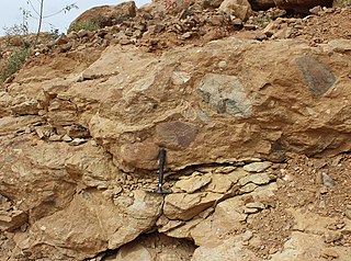
The Edaga Arbi Glacials are a Palaeozoic geological formation in Tigray and in Eritrea. The matrix is composed of grey, black and purple clays, that contains rock fragments up to 6 metres across. Pollen dating yields a Late Carboniferous to Early Permian age.

References

  1. Bard, Edouard (June 2004). "Effet de serre et glaciations, une perspective historique" [Greenhouse effect and ice ages: historical perspective]. Comptes Rendus Geoscience (in French). 336 (7–8): 603–638. Bibcode:2004CRGeo.336..603B. doi:10.1016/j.crte.2004.02.005.
  2. Geikie, Sir Archibald (1882). "Textbook of geology". Macmillan. Retrieved 2009-12-12. erratic glacier.{{cite journal}}: Cite journal requires |journal= (help)
  3. Bell, Robin E. (27 April 2008). "The role of subglacial water in ice-sheet mass balance". Nature Geoscience . 1 (5802): 297–304. Bibcode:2008NatGe...1..297B. doi:10.1038/ngeo186.
  4. Rempel, A. W. (2008). "theory for ice-till interactions and sediment entrainment beneath glaciers". Journal of Geophysical Research. 113 (113). American Geophysical Union: F01013. Bibcode:2008JGRF..113.1013R. doi: 10.1029/2007JF000870 . S2CID   11082114.
  5. 1 2 3 4 5 6 7 8 Evenson, Edward B.; Burkhart, Patrick A.; Gosse, John C.; Baker, Gregory S.; Jackofsky, Dan; Meglioli, Andres; Dalziel, Ian; Kraus, Stefan; Alley, Richard B.; Berti, Claudio (December 2009). "Enigmatic boulder trains, supraglacial rock avalanches, and the origin of "Darwin's boulders," Tierra del Fuego". GSA Today. 19 (12). The Geological Society of America: 4–10. doi: 10.1130/GSATG72A.1 .
  6. Evans, David J.A.; Chris D. Clark; Wishart A. Mitchell (May 2005). "The last British Ice Sheet: A review of the evidence utilised in the compilation of the Glacial Map of Britain". Earth-Science Reviews. 70 (3–4). Copyright © 2005 Elsevier B.V: 253. Bibcode:2005ESRv...70..253E. doi:10.1016/j.earscirev.2005.01.001 . Retrieved 10 September 2013.
  7. 1 2 Bond, Gerard; Heinrich, Hartmut; Broecker, Wallace; Labeyrie, Laurent; McManus, Jerry; Andrews, John; Huon, Sylvain; Jantschik, Ruediger; Clasen, Silke; Simet, Christine; Tedesco, Kathy; Klas, Mieczyslawa; Bonani, Georges; Ivy, Susan (1992). "Evidence for massive discharges of icebergs into the North Atlantic ocean during the last glacial period". Nature. 360 (6401): 245–249. Bibcode:1992Natur.360..245B. doi:10.1038/360245a0. S2CID   4339371.
  8. Tripatia, Aradhna K.; Eagleb, Robert A.; Mortonc, Andrew; Dowdeswelld, Julian A.; Atkinsone, Katie L.; Bahéf, Yannick; Dawbera, Caroline F.; Khadung, Emma; Shawa, Ruth M.H.; Shorttleh, Oliver; Thanabalasundarami, Lavaniya (2007). "Evidence for glaciation in the Northern Hemisphere back to 44 Ma from ice-rafted debris in the Greenland Sea". Earth and Planetary Science Letters. 265 (1–2). Elsevier B.V.: 112–122. Bibcode:2008E&PSL.265..112T. doi:10.1016/j.epsl.2007.09.045.
  9. Davisa, Niole K.; Locke III, William W.; Pierce, Kenneth L.; Finkel, Robert C. (May 2006). "Glacial Lake Musselshell: Late Wisconsin slackwater on the Laurentide ice margin in central Montana, USA". Geomorphology. 75 (3–4). Elsevier B.V.: 330–345. Bibcode:2006Geomo..75..330D. doi:10.1016/j.geomorph.2005.07.021.
  10. Talbot, Christopher J. (April 1999). "Ice ages and nuclear waste isolation". Engineering Geology. 52 (3–4). Elsevier Science: 177–192. doi:10.1016/S0013-7952(99)00005-8.
  11. Paduan, Jennifer B.; Clague, David A.; Davis, Alicé S. (2007-11-28). "Erratic continental rocks on volcanic seamounts off the US west coast". Marine Geology. 246 (1): 1–8. Bibcode:2007MGeol.246....1P. doi:10.1016/j.margeo.2007.07.007.
  12. David Roger Oldroyd, "Thoughts about climate, glaciation and carving the Earth's surface", ch. 7 in, Thinking about the Earth: A History of Ideas in Geology, Harvard University Press, 1996 ISBN   0674883829.
  13. Principles of Geology, Volume 1; Sir Charles Lyell - Geology - 1830
  14. 1 2 E.P. Evans: "The Authorship of the Glacial Theory", North American review Volume 145, Issue 368, July 1887. Accessed on 25 February 2008.
  15. Cameron, Dorothy (1964). Early discoverers XXII, Goethe-Discoverer of the ice age. Journal of glaciology (PDF).
  16. Edward B. Evenson, Patrick A. Burkhart, John C. Gosse, Gregory S. Baker, Dan Jackofsky, Andres Meglioli, Ian Dalziel, Stefan Kraus, Richard B. Alley, Claudio Berti; "Enigmatic boulder trains, supraglacial rock avalanches, and the origin of "Darwin's boulders", Tierra del Fuego; GSA Today; Volume 19 Issue 12 (December 2009); pp. 4–10
  17. Bleasdell, Rev. William (1872). "On Modern Glacial Action in Canada". Quarterly Journal of the Geological Society. 28 (1–2): 392–396. doi:10.1144/GSL.JGS.1872.028.01-02.45. S2CID   129757092.
  18. "Lauču(Lauchu) stones - vidlauci.lv". www.vidlauci.lv. Retrieved 2021-07-04.
  19. "Glacial erratic - Coronation Park, Crosby". Geograph UK.
  20. "On the Bradford District's Western Boundary". www.bradfordhistorical.org.uk. Retrieved 2018-06-02.
  21. "Soulbury stone: White lines 'horrific' and 'an eyesore'". BBC. 16 April 2016.

Commons-logo.svg Media related to Glacial erratics at Wikimedia Commons