Related Research Articles

A glacier is a persistent body of dense ice that is constantly moving under its own weight. A glacier forms where the accumulation of snow exceeds its ablation over many years, often centuries. It acquires distinguishing features, such as crevasses and seracs, as it slowly flows and deforms under stresses induced by its weight. As it moves, it abrades rock and debris from its substrate to create landforms such as cirques, moraines, or fjords. Although a glacier may flow into a body of water, it forms only on land and is distinct from the much thinner sea ice and lake ice that form on the surface of bodies of water.

A moraine is any accumulation of unconsolidated debris, sometimes referred to as glacial till, that occurs in both currently and formerly glaciated regions, and that has been previously carried along by a glacier or ice sheet. It may consist of partly rounded particles ranging in size from boulders down to gravel and sand, in a groundmass of finely-divided clayey material sometimes called glacial flour. Lateral moraines are those formed at the side of the ice flow, and terminal moraines were formed at the foot, marking the maximum advance of the glacier. Other types of moraine include ground moraines and medial moraines.

An esker, eskar, eschar, or os, sometimes called an asar, osar, or serpent kame, is a long, winding ridge of stratified sand and gravel, examples of which occur in glaciated and formerly glaciated regions of Europe and North America. Eskers are frequently several kilometres long and, because of their uniform shape, look like railway embankments.

Glaciology is the scientific study of glaciers, or, more generally, ice and natural phenomena that involve ice.
Landforms are categorized by characteristic physical attributes such as their creating process, shape, elevation, slope, orientation, rock exposure, and soil type.
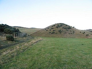
A kame, or knob, is a glacial landform, an irregularly shaped hill or mound composed of sand, gravel and till that accumulates in a depression on a retreating glacier, and is then deposited on the land surface with further melting of the glacier. Kames are often associated with kettles, and this is referred to as kame and kettle or knob and kettle topography. The word kame is a variant of comb, which has the meaning "crest" among others. The geological term was introduced by Thomas Jamieson in 1874.

A kettle is a depression or hole in an outwash plain formed by retreating glaciers or draining floodwaters. The kettles are formed as a result of blocks of dead ice left behind by retreating glaciers, which become surrounded by sediment deposited by meltwater streams as there is increased friction. The ice becomes buried in the sediment and when the ice melts, a depression is left called a kettle hole, creating a dimpled appearance on the outwash plain. Lakes often fill these kettles; these are called kettle hole lakes. Another source is the sudden drainage of an ice-dammed lake and when the block melts, the hole it leaves behind is a kettle. As the ice melts, ramparts can form around the edge of the kettle hole. The lakes that fill these holes are seldom more than 10 m (33 ft) deep and eventually fill with sediment. In acid conditions, a kettle bog may form but in alkaline conditions, it will be kettle peatland.

Glacial motion is the motion of glaciers, which can be likened to rivers of ice. It has played an important role in sculpting many landscapes. Most lakes in the world occupy basins scoured out by glaciers. Glacial motion can be fast or slow, but is typically around 25 centimetres per day (9.8 in/d).

Glacial landforms are landforms created by the action of glaciers. Most of today's glacial landforms were created by the movement of large ice sheets during the Quaternary glaciations. Some areas, like Fennoscandia and the southern Andes, have extensive occurrences of glacial landforms; other areas, such as the Sahara, display rare and very old fossil glacial landforms.
The Oak Ridges Moraine is a geological landform that runs east-west across south central Ontario, Canada. It developed about 12,000 years ago, during the Wisconsin glaciation in North America. A complex ridge of sedimentary material, the moraine is known to have partially developed under water. The Niagara Escarpment played a key role in forming the moraine in that it acted as a dam for glacial meltwater trapped between it and two ice lobes.

A terminal moraine, also called an end moraine, is a type of moraine that forms at the terminal (edge) of a glacier, marking its maximum advance. At this point, debris that has accumulated by plucking and abrasion, has been pushed by the front edge of the ice, is driven no further and instead is deposited in an unsorted pile of sediment. Because the glacier acts very much like a conveyor belt, the longer it stays in one place, the greater the amount of material that will be deposited. The moraine is left as the marking point of the terminal extent of the ice.
In geology, drift is a name for all sediment transported by a glacier and deposited directly by or from the ice, or by glacial meltwater. Drift is often subdivided into unstratified drift that forms moraines and stratified drift that accumulates as stratified and sorted sediments in the form of outwash plains, eskers, kames, varves, and so forth. The term drift clay is a synonym for boulder clay. Both are archaic terms for glacial tills with a fine-grained matrix.

In geology, a terrace is a step-like landform. A terrace consists of a flat or gently sloping geomorphic surface, called a tread, that is typically bounded on one side by a steeper ascending slope, which is called a "riser" or "scarp". The tread and the steeper descending slope together constitute the terrace. Terraces can also consist of a tread bounded on all sides by a descending riser or scarp. A narrow terrace is often called a bench.
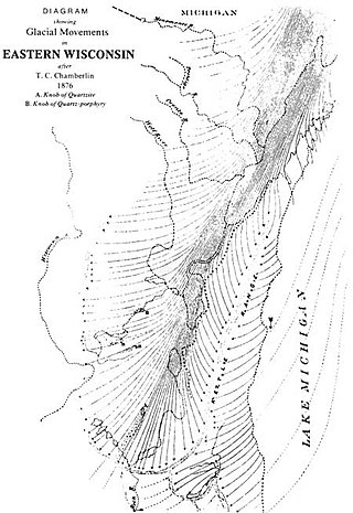
Kettle Moraine is a large moraine in the state of Wisconsin, United States. It stretches from Walworth County in the south to Kewaunee County in the north. It has also been referred to as the Kettle Range and, in geological texts, as the Kettle Interlobate Moraine.
A subaqueous fan is a fan-shaped deposit formed beneath water, that is commonly related to glaciers and crater lakes.

The glacial history of Minnesota is most defined since the onset of the last glacial period, which ended some 10,000 years ago. Within the last million years, most of the Midwestern United States and much of Canada were covered at one time or another with an ice sheet. This continental glacier had a profound effect on the surface features of the area over which it moved. Vast quantities of rock and soil were scraped from the glacial centers to its margins by slowly moving ice and redeposited as drift or till. Much of this drift was dumped into old preglacial river valleys, while some of it was heaped into belts of hills at the margin of the glacier. The chief result of glaciation has been the modification of the preglacial topography by the deposition of drift over the countryside. However, continental glaciers possess great power of erosion and may actually modify the preglacial land surface by scouring and abrading rather than by the deposition of the drift.
Fluvioglacial landforms or glaciofluvial landforms are those that result from the associated erosion and deposition of sediments caused by glacial meltwater. Glaciers contain suspended sediment loads, much of which is initially picked up from the underlying landmass. Landforms are shaped by glacial erosion through processes such as glacial quarrying, abrasion, and meltwater. Glacial meltwater contributes to the erosion of bedrock through both mechanical and chemical processes. Fluvio-glacial processes can occur on the surface and within the glacier. The deposits that happen within the glacier are revealed after the entire glacier melts or partially retreats. Fluvio-glacial landforms and erosional surfaces include: outwash plains, kames, kame terraces, kettle holes, eskers, varves, and proglacial lakes.
Subglacial streams are conduits of glacial meltwater that flow at the base of glaciers and ice caps. Meltwater from the glacial surface travels downward throughout the glacier, forming an englacial drainage system consisting of a network of passages that eventually reach the bedrock below, where they form subglacial streams. Subglacial streams form a system of tunnels and interlinked cavities and conduits, with water flowing under extreme pressures from the ice above; as a result, flow direction is determined by the pressure gradient from the ice and the topography of the bed rather than gravity. Subglacial streams form a dynamic system that is responsive to changing conditions, and the system can change significantly in response to seasonal variation in meltwater and temperature. Water from subglacial streams is routed towards the glacial terminus, where it exits the glacier. Discharge from subglacial streams can have a significant impact on local, and in some cases global, environmental and geological conditions. Sediments, nutrients, and organic matter contained in the meltwater can all influence downstream and marine conditions. Climate change may have a significant impact on subglacial stream systems, increasing the volume of meltwater entering subglacial drainage systems and influencing their hydrology.
The glacial series refers to a particular sequence of landforms in Central Europe that were formed during the Pleistocene glaciation beneath the ice sheets, along their margins and on their forelands during each glacial advance.
A meltwater channel is a channel cut into ice, bedrock or unconsolidated deposits by the flow of water derived from the melting of a glacier or ice-sheet. The channel may form on the surface of, within, beneath, along the margins of or downstream from the ice mass. Accordingly it would be referred to as supraglacial, englacial, subglacial, lateral or proglacial.
References
- ↑ Herbert Bucksch (1997). Dictionary Geotechnical Engineering/ Wörterbuch GeoTechnik: Vol 1. p. 688. ISBN 978-3-662-03325-8.
- ↑ "CMECS: Glacial (Kame) Delta". www.cmecscatalog.org. Archived from the original on 2016-03-09. Retrieved 2015-12-17.
- 1 2 "Kame". www.landforms.eu. Retrieved 2015-12-17.
- ↑ "Glacialfeatures". dabbler.org. Retrieved 2015-12-17.
- ↑ "Glacial Meltwater Landforms" (PDF).
- ↑ "Fonthill Kame-Delta". Niagara Green Belt. Archived from the original on October 10, 2011. Retrieved July 17, 2011.
- ↑ "Glacial Park | McHenry County Conservation District". www.mccdistrict.org. Archived from the original on 2015-12-13. Retrieved 2015-12-17.
- ALLABY, AILSA; ALLABY, MICHAEL (1999), "Kame delta", A Dictionary of Earth Sciences, retrieved October 6, 2011– via Encyclopedia.com