A glacier head is the top of a glacier. Although glaciers seem motionless to the observer they are in constant motion and the terminus is always either advancing or retreating.[1]
The accumulation zone is found at the highest altitude of the glacier, where accumulation of material is greater than ablation.
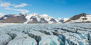
On a glacier, the accumulation zone is the area above the firn line, where snowfall accumulates and exceeds the losses from ablation, (melting, evaporation, and sublimation). The annual equilibrium line separates the accumulation and ablation zone annually. The accumulation zone is also defined as the part of a glacier's surface, usually at higher elevations, on which there is net accumulation of snow, which subsequently turns into firn and then glacier ice. Part of the glacier where snow builds up and turns to ice moves outward from there.
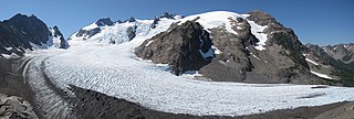
The glacier head is the highest upslope edge of an alpine glacier or the upslope end of the zone of accumulation. The head of the glacier comes up against a steep bedrock cliff called a cirqueheadwall[2]
Cross section of a cirque glacier showing the bergschrund
Movement and ice loss
The head can come away from the cirque in a downslope movement which can create a large crevasse called a bergschrund. This crevasse can be a major obstacle for mountaineers. The existence of a bergschrund is evidence that ice mass has pulled away from the cirque.[2]
A shrinking glacier thins faster near the terminus than near the head, which explains why glaciers retreat up-valley and the glacier head stays in place[3]
The speed of erosion or accumulation is partly dependent on a shape factor which is the ratio of the change in thickness at the glacier head to the change in the thickness at the terminus.[4]
A glacier is a persistent body of dense ice that is constantly moving under its own weight. A glacier forms where the accumulation of snow exceeds its ablation over many years, often centuries. It acquires distinguishing features, such as crevasses and seracs, as it slowly flows and deforms under stresses induced by its weight. As it moves, it abrades rock and debris from its substrate to create landforms such as cirques, moraines, or fjords. Although a glacier may flow into a body of water, it forms only on land and is distinct from the much thinner sea ice and lake ice that form on the surface of bodies of water.
Glaciology is the scientific study of glaciers, or more generally ice and natural phenomena that involve ice.
The Aletsch Glacier or Great Aletsch Glacier is the largest glacier in the Alps. It has a length of about 23 km (14 mi) (2014), has about a volume of 15.4 km3 (3.7 cu mi) (2011), and covers about 81.7 km2 (2011) in the eastern Bernese Alps in the Swiss canton of Valais. The Aletsch Glacier is composed of four smaller glaciers converging at Konkordiaplatz, where its thickness was measured by the ETH to be still near 1 km (3,300 ft). It then continues towards the Rhône valley before giving birth to the Massa. The Aletsch Glacier is – like most glaciers in the world today – a retreating glacier. As of 2016, since 1980 it lost 1.3 kilometres (0.81 mi) of its length, since 1870 3.2 kilometres (2.0 mi), and lost also more than 300 metres (980 ft) of its thickness.
A crevasse is a deep crack, that forms in a glacier or ice sheet that can be a few inches across to over 40 feet. Crevasses form as a result of the movement and resulting stress associated with the shear stress generated when two semi-rigid pieces above a plastic substrate have different rates of movement. The resulting intensity of the shear stress causes a breakage along the faces.
The climatic snow line is the boundary between a snow-covered and snow-free surface. The actual snow line may adjust seasonally, and be either significantly higher in elevation, or lower. The permanent snow line is the level above which snow will lie all year.
A cirque is an amphitheatre-like valley formed by glacial erosion. Alternative names for this landform are corrie and cwm. A cirque may also be a similarly shaped landform arising from fluvial erosion.
A dirt cone is a type of depositional glacial feature. Dirt cones are not actually made entirely of dirt. They have a core of ice, snow, or firn that gets covered with material and insulated. The material, if it is thick enough, will protect the underlying core from ablation. The thickness of material needed to insulate the core is called the “critical thickness.” If the material is less thick than the critical thickness, it will actually speed up erosion of the core through ablation. This is called “indirect ablation.” The cone would then begin melting and shrinking away.
A bergschrund is a crevasse that forms where moving glacier ice separates from the stagnant ice or firn above. It is often a serious obstacle for mountaineers, who sometimes abbreviate "bergschrund" to "schrund". Bergschrunds extend to the bedrock and can have a depth of well over 100 metres (330 ft).
Névé is a young, granular type of snow which has been partially melted, refrozen and compacted, yet precedes the form of ice. This type of snow is associated with glacier formation through the process of nivation. Névé that survives a full season of ablation turns into firn, which is both older and slightly denser. Firn eventually becomes glacial ice – the long-lived, compacted ice that glaciers are composed of. Glacier formation can take years to hundreds of years depending on freeze-thaw factors and snow compaction rates. Névé is annually observed in skiing slopes, and is generally disliked as an icy falling zone.
Crucial to the survival of a glacier is its mass balance of which surface mass balance (SMB), the difference between accumulation and ablation. Climate change may cause variations in both temperature and snowfall, causing changes in the surface mass balance. Changes in mass balance control a glacier's long-term behavior and are the most sensitive climate indicators on a glacier. From 1980 to 2012 the mean cumulative mass loss of glaciers reporting mass balance to the World Glacier Monitoring Service is −16 m. This includes 23 consecutive years of negative mass balances.
Glacier ice accumulation occurs through accumulation of snow and other frozen precipitation, as well as through other means including rime ice, avalanching from hanging glaciers on cliffs and mountainsides above, and re-freezing of glacier meltwater as superimposed ice. Accumulation is one element in the glacier mass balance formula, with ablation counteracting. With successive years in which accumulation exceeds ablation, then a glacier will experience positive mass balance, and its terminus will advance.
Ablation zone or ablation area refers to the low-altitude area of a glacier or ice sheet below firn with a net loss in ice mass due to melting, sublimation, evaporation, ice calving, aeolian processes like blowing snow, avalanche, and any other ablation. The equilibrium line altitude (ELA) or snow line separates the ablation zone from the higher-altitude accumulation zone. The ablation zone often contains meltwater features such as supraglacial lakes, englacial streams, and subglacial lakes. Sediments dropped in the ablation zone forming small mounds or hillocks are called kames. Kame and kettle hole topography is useful in identifying an ablation zone of a glacier. The seasonally melting glacier deposits much sediment at its fringes in the ablation area. Ablation constitutes a key part of the glacier mass balance.
Glacier morphology, or the form a glacier takes, is influenced by temperature, precipitation, topography, and other factors. The goal of glacial morphology is to gain a better understanding of glaciated landscapes and the way they are shaped. Types of glaciers can range from massive ice sheets, such as the Greenland ice sheet, to small cirque glaciers found perched on mountain tops. Glaciers can be grouped into two main categories:
On a glacier, the accumulation zone is the area above the firn line, where snowfall accumulates and exceeds the losses from ablation,. The annual equilibrium line separates the accumulation and ablation zone annually. The accumulation zone is also defined as the part of a glacier's surface, usually at higher elevations, on which there is net accumulation of snow, which subsequently turns into firn and then glacier ice. Part of the glacier where snow builds up and turns to ice moves outward from there.
Lower Curtis Glacier is in North Cascades National Park in the U.S. state of Washington. Named for photographer Asahel Curtis, the glacier is in a cirque on the western slopes of Mount Shuksan. Lower Curtis Glacier is rapidly retreating and has a negative mass balance, meaning that the rate of snow and ice that is falling in the accumulation zone is less than that which is lost each year in the ablation zone. Between 1908 and 1984, the glacier experienced a loss of thickness by 45 meters (147 ft). Between 1984 and 2002, the glacier lost another 6 meters (19 ft) in thickness. Lower Curtis Glacier also lost 28% of its surface area between the end of the little ice age and 1950. Between the years 1951 and 1979, the glacier actually lengthened by 245 meters (800 ft) but has retreated 184 m (600 ft) since 1985, partly due to the tongue of the glacier being on a steep precipice which may have increased the loss of ice at the termini.
Blue Glacier is a large glacier located to the north of Mount Olympus in the Olympic Mountains of Washington. The glacier covers an area of 1.7 sq mi (4.4 km2) and contains 580,000,000 cu ft (16,000,000 m3) of ice and snow in spite of its low terminus elevation. The glacier length has decreased from about 3.4 mi (5.5 km) in 1800 to 2.7 mi (4.3 km) in the year 2000. Just in the period from 1995 and 2006, Blue Glacier retreated 325 ft (99 m). Blue Glacier is also thinning as it retreats and between 1987 and 2009 the glacier lost 178 ft (54 m) of its depth near its terminus and between 32 and 48 ft in the uppermost sections of the glacier known as the accumulation zone.
The Miage Glacier is a debris-covered glacier in the upper Aosta Valley, in northwestern Italy.
The Schneeferner in the Bavarian Alps is Germany's highest and largest glacier.
A randkluft or rimaye is the headwall gap between a glacier or snowfield and the adjacent rock face at the back of the cirque or, more loosely, between the rock face and the side of the glacier.
A glacier stream is a channelized area that is formed by a glacier in which liquid water accumulates and flows. Glacial streams are also commonly referred to as "glacier stream" or/and "glacial meltwater stream". The movement of the water is influenced and directed by gravity and the melting of ice. The melting of ice forms different types of glacial streams such as supraglacial, englacial, subglacial and proglacial streams. Water enters supraglacial streams that sit at the top of the glacier via filtering through snow in the accumulation zone and forming slush pools at the FIRN zone. The water accumulates on top of the glacier in supraglacial lakes and into supraglacial stream channels. The meltwater then flows through various different streams either entering inside the glacier into englacial channels or under the glacier into subglacial channels. Finally, the water leaves the glacier through proglacial streams or lakes. Proglacial streams do not only act as the terminus point but can also receive meltwater. Glacial streams can play a significant role in energy exchange and in the transport of meltwater and sediment.
This page is based on this Wikipedia article Text is available under the CC BY-SA 4.0 license; additional terms may apply. Images, videos and audio are available under their respective licenses.