A drumlin, from the Irish word droimnín, first recorded in 1833, in the classical sense is an elongated hill in the shape of an inverted spoon or half-buried egg formed by glacial ice acting on underlying unconsolidated till or ground moraine. Assemblages of drumlins are referred to as fields or swarms; they can create a landscape which is often described as having a 'basket of eggs topography'.
Alluvium is loose clay, silt, sand, or gravel that has been deposited by running water in a stream bed, on a floodplain, in an alluvial fan or beach, or in similar settings. Alluvium is also sometimes called alluvial deposit. Alluvium is typically geologically young and is not consolidated into solid rock. Sediments deposited underwater, in seas, estuaries, lakes, or ponds, are not described as alluvium.

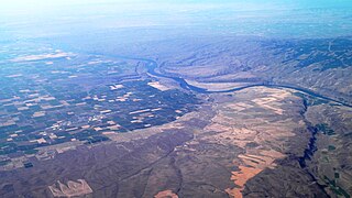
The Missoula floods were cataclysmic glacial lake outburst floods that swept periodically across eastern Washington and down the Columbia River Gorge at the end of the last ice age. These floods were the result of periodic sudden ruptures of the ice dam on the Clark Fork River that created Glacial Lake Missoula. After each ice dam rupture, the waters of the lake would rush down the Clark Fork and the Columbia River, flooding much of eastern Washington and the Willamette Valley in western Oregon. After the lake drained, the ice would reform, creating Glacial Lake Missoula again.

The Last Glacial Period (LGP), also known colloquially as the Last Ice Age or simply Ice Age, occurred from the end of the Last Interglacial to the end of the Younger Dryas, encompassing the period c. 115,000 – c. 11,700 years ago.
In geology, a proglacial lake is a lake formed either by the damming action of a moraine during the retreat of a melting glacier, a glacial ice dam, or by meltwater trapped against an ice sheet due to isostatic depression of the crust around the ice. At the end of the last ice age about 10,000 years ago, large proglacial lakes were a widespread feature in the northern hemisphere.

The Channeled Scablands are a relatively barren and soil-free region of interconnected relict and dry flood channels, coulees and cataracts eroded into Palouse loess and the typically flat-lying basalt flows that remain after cataclysmic floods within the southeastern part of Washington state. The Channeled Scablands were scoured by more than 40 cataclysmic floods during the Last Glacial Maximum and innumerable older cataclysmic floods over the last two million years. These floods were periodically unleashed whenever a large glacial lake broke through its ice dam and swept across eastern Washington and down the Columbia River Plateau during the Pleistocene epoch. The last of the cataclysmic floods occurred between 18,200 and 14,000 years ago.
Colluvium is a general name for loose, unconsolidated sediments that have been deposited at the base of hillslopes by either rainwash, sheetwash, slow continuous downslope creep, or a variable combination of these processes. Colluvium is typically composed of a heterogeneous range of rock types and sediments ranging from silt to rock fragments of various sizes. This term is also used to specifically refer to sediment deposited at the base of a hillslope by unconcentrated surface runoff or sheet erosion.
The Illinoian Stage is the name used by Quaternary geologists in North America to designate the period c.191,000 to c.130,000 years ago, during the Chibanian stage of the Pleistocene, when sediments comprising the Illinoian Glacial Lobe were deposited. It precedes the Sangamonian Stage and follows the Pre-Illinoian Stage in North America. The Illinoian Stage is defined as the period of geologic time during which the glacial tills and outwash, which comprise the bulk of the Glasford Formation, accumulated to create the Illinoian Glacial Lobe. It occurs at about the same time as the penultimate glacial period.
The Yarmouthian stage and the Yarmouth Interglacial were part of a now obsolete geologic timescale of the early Quaternary of North America.
Parent material is the underlying geological material in which soil horizons form. Soils typically inherit a great deal of structure and minerals from their parent material, and, as such, are often classified based upon their contents of consolidated or unconsolidated mineral material that has undergone some degree of physical or chemical weathering and the mode by which the materials were most recently transported.
In geology, drift is a name for all sediment transported by a glacier and deposited directly by or from the ice, or by glacial meltwater. Drift is often subdivided into unstratified drift that forms moraines and stratified drift that accumulates as stratified and sorted sediments in the form of outwash plains, eskers, kames, varves, and so forth. The term drift clay is a synonym for boulder clay. Both are archaic terms for glacial tills with a fine-grained matrix.

A glacial lake outburst flood (GLOF) is a type of outburst flood caused by the failure of a dam containing a glacial lake. An event similar to a GLOF, where a body of water contained by a glacier melts or overflows the glacier, is called a jökulhlaup. The dam can consist of glacier ice or a terminal moraine. Failure can happen due to erosion, a buildup of water pressure, an avalanche of rock or heavy snow, an earthquake or cryoseism, volcanic eruptions under the ice, or massive displacement of water in a glacial lake when a large portion of an adjacent glacier collapses into it.
Superficial deposits refer to geological deposits typically of Quaternary age for the Earth. These geologically recent unconsolidated sediments may include stream channel and floodplain deposits, beach sands, talus gravels and glacial drift and moraine. All pre-Quaternary deposits are referred to as bedrock.

A clastic dike is a seam of sedimentary material that fills an open fracture in and cuts across sedimentary rock strata or layering in other rock types.
The Sangamonian Stage is the term used in North America to designate the Last Interglacial and depending on definition, part of the early Last Glacial Period, corresponding to Marine Isotope Stage 5. While often historically considered equivalent in scope to MIS 5, it is now often used in a more narrow sense to refer to the Last Interglacial only. It preceded the Wisconsinan (Wisconsin) Stage and followed the Illinoian Stage in North America.
Ledoyom is a term proposed by the Russian geologist Vasily Nekhoroshev for intermontane depressions which might get completely filled by glaciers from the surrounding mountains at the maxima of glaciation.
Giant current ripples, giant gravel bars, gravel dunes or GCRs are a form of subaqueous dune. They are active channel topographic forms up to 20 m high, which occur within near-thalweg areas of the main outflow routes created by glacial lake outburst floods. Giant current ripple marks are large scale analogues of small current ripples formed by sand in streams. Giant current ripple marks are important features associated with scablands. As a landscape component, they are found in several areas that were previously in the vicinity of large glacial lakes.
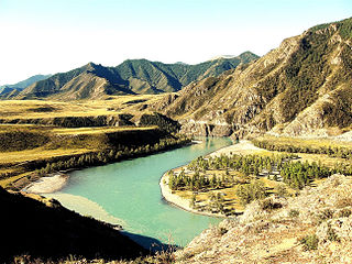
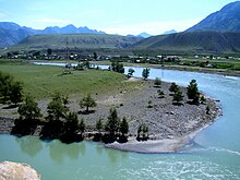
The Altai flood refers to the cataclysmic flood(s) that, according to some geomorphologists, swept along the Katun River in the Altai Republic at the end of the last ice age. These glacial lake outburst floods were the result of periodic sudden ruptures of ice dams like those triggering the Missoula floods.

The geology of Rhode Island is based on nearly one billion year old igneous crystalline basement rocks formed as part of the microcontinent Avalonia that collided with the supercontinent Gondwana. The region experienced substantial folding associated with its landlocked position during the Alleghanian orogeny mountain building event. The region accumulated sedimentary rocks, including small deposits of coal. The region was covered with thick Atlantic Coastal Plain sediments, with the erosion of the Appalachians and the creation of the Atlantic Ocean throughout the past 200 million years. These surficial sediments and soils were substantially reworked by the Pleistocene glaciations. The state's geology is part of the broader geology of New England.
Dream Cave is a natural limestone cavern located near Wirksworth in Derbyshire, England. It was discovered by lead miners in 1822 and was found to contain the almost complete skeletal remains of a woolly rhinoceros and other large mammal bones. These remains were acquired by the geologist William Buckland and are now housed in Oxford Museum.