The Pleistocene is the geological epoch that lasted from c. 2.58 million to 11,700 years ago, spanning the Earth's most recent period of repeated glaciations. Before a change was finally confirmed in 2009 by the International Union of Geological Sciences, the cutoff of the Pleistocene and the preceding Pliocene was regarded as being 1.806 million years Before Present (BP). Publications from earlier years may use either definition of the period. The end of the Pleistocene corresponds with the end of the last glacial period and also with the end of the Paleolithic age used in archaeology. The name is a combination of Ancient Greek πλεῖστος (pleîstos), meaning "most", and καινός, meaning "new".

Beringia is defined today as the land and maritime area bounded on the west by the Lena River in Russia; on the east by the Mackenzie River in Canada; on the north by 72 degrees north latitude in the Chukchi Sea; and on the south by the tip of the Kamchatka Peninsula. It includes the Chukchi Sea, the Bering Sea, the Bering Strait, the Chukchi and Kamchatka Peninsulas in Russia as well as Alaska in the United States and the Yukon in Canada.

Haida Gwaii is an archipelago located between 55–125 km (34–78 mi) off the northern Pacific coast of Canada. The islands are separated from the mainland to the east by the shallow Hecate Strait. Queen Charlotte Sound lies to the south, with Vancouver Island beyond. To the north, the disputed Dixon Entrance separates Haida Gwaii from the Alexander Archipelago in the U.S. state of Alaska.

The Wisconsin Glacial Episode, also called the Wisconsin glaciation, was the most recent glacial period of the North American ice sheet complex. This advance included the Cordilleran Ice Sheet, which nucleated in the northern North American Cordillera; the Innuitian ice sheet, which extended across the Canadian Arctic Archipelago; the Greenland ice sheet; and the massive Laurentide Ice Sheet, which covered the high latitudes of central and eastern North America. This advance was synchronous with global glaciation during the last glacial period, including the North American alpine glacier advance, known as the Pinedale glaciation. The Wisconsin glaciation extended from approximately 75,000 to 11,000 years ago, between the Sangamonian Stage and the current interglacial, the Holocene. The maximum ice extent occurred approximately 25,000–21,000 years ago during the last glacial maximum, also known as the Late Wisconsin in North America.

The Last Glacial Period (LGP), also known colloquially as the last ice age or simply ice age, occurred from the end of the Eemian to the end of the Younger Dryas, encompassing the period c. 115,000 – c. 11,700 years ago. The LGP is part of a larger sequence of glacial and interglacial periods known as the Quaternary glaciation which started around 2,588,000 years ago and is ongoing. The definition of the Quaternary as beginning 2.58 million years ago (Mya) is based on the formation of the Arctic ice cap. The Antarctic ice sheet began to form earlier, at about 34 Mya, in the mid-Cenozoic. The term Late Cenozoic Ice Age is used to include this early phase. The previous ice age, the Saale glaciation, which ended about 128,000 years ago, was more severe than the Last Glacial Period in some areas such as Britain, but less severe in others.

Post-glacial rebound is the rise of land masses after the removal of the huge weight of ice sheets during the last glacial period, which had caused isostatic depression. Post-glacial rebound and isostatic depression are phases of glacial isostasy, the deformation of the Earth's crust in response to changes in ice mass distribution. The direct raising effects of post-glacial rebound are readily apparent in parts of Northern Eurasia, Northern America, Patagonia, and Antarctica. However, through the processes of ocean siphoning and continental levering, the effects of post-glacial rebound on sea level are felt globally far from the locations of current and former ice sheets.

The Last Glacial Maximum (LGM), also referred to as the Last Glacial Coldest Period, was the most recent time during the Last Glacial Period that ice sheets were at their greatest extent 26 ka - 20 ka, during an interval of low obliquity. Ice sheets covered much of Northern North America, Northern Europe, and Asia and profoundly affected Earth's climate by causing a major expansion of deserts, along with a large drop in sea levels. Based on changes in position of ice sheet margins dated via terrestrial cosmogenic nuclides and radiocarbon dating, growth of ice sheets commenced 33,000 years ago and maximum coverage has been estimated to have occurred sometime between 26,500 years ago and 20,000 years ago. After this, deglaciation commenced in the Northern Hemisphere, causing an abrupt rise in sea level. Decline of the West Antarctica ice sheet occurred between 14,000 and 15,000 years ago, consistent with evidence for another abrupt rise in the sea level about 14,500 years ago. Glacier fluctuations around the Strait of Magellan suggest the peak in glacial surface area was constrained to between 25,200 and 23,100 years ago. Continental ice sheets never reached their isostatic equilibrium during the LGM, as evidenced by high variability in ice volume over short spans of time.

The Laurentide Ice Sheet was a massive sheet of ice that covered millions of square miles, including most of Canada and a large portion of the Northern United States, multiple times during the Quaternary glacial epochs, from 2.58 million years ago to the present.
In glaciology, starvation occurs when a glacier retreats, not because of temperature increases, but due to precipitation so low that the ice flow downward into the zone of ablation exceeds the replenishment from snowfall. Eventually, the ice will move so far down that it either calves into the ocean or melts.
The Quaternary glaciation, also known as the Pleistocene glaciation, is an alternating series of glacial and interglacial periods during the Quaternary period that began 2.58 Ma and is ongoing. Although geologists describe this entire period up to the present as an "ice age", in popular culture this term usually refers to the most recent glacial period, or to the Pleistocene epoch in general. Since Earth still has polar ice sheets, geologists consider the Quaternary glaciation to be ongoing, though currently in an interglacial period.

Meltwater pulse 1A (MWP1a) is the name used by Quaternary geologists, paleoclimatologists, and oceanographers for a period of rapid post-glacial sea level rise, between 13,500 and 14,700 calendar years ago, during which global sea level rose between 16 meters (52 ft) and 25 meters (82 ft) in about 400–500 years, giving mean rates of roughly 40–60 mm (0.13–0.20 ft)/yr. Meltwater pulse 1A is also known as catastrophic rise event 1 (CRE1) in the Caribbean Sea. The rates of sea level rise associated with meltwater pulse 1A are the highest known rates of post-glacial, eustatic sea level rise. Meltwater pulse 1A is also the most widely recognized and least disputed of the named, postglacial meltwater pulses. Other named, postglacial meltwater pulses are known most commonly as meltwater pulse 1A0, meltwater pulse 1B, meltwater pulse 1C, meltwater pulse 1D, and meltwater pulse 2. It and these other periods of rapid sea level rise are known as meltwater pulses because the inferred cause of them was the rapid release of meltwater into the oceans from the collapse of continental ice sheets.

The Insular Mountains are a range of mountains in the Pacific Coast Ranges on the Coast of British Columbia, Canada, comprising the Vancouver Island Ranges and Queen Charlotte Mountains. The Insular Mountains are rugged, particularly on Vancouver Island where peaks in Strathcona Provincial Park rise to elevations of more than 2,000 m (6,562 ft). The highest of these mountains is Golden Hinde on Vancouver Island, which rises to 2,196.818 m (7,207 ft).
The Haida Gwaii black bear, also known as the Queen Charlotte Islands black bear, is a morphologically distinct subspecies of the American black bear. The most significant morphological differences are its large size, massive cranium and large molars. This subspecies is endemic to the Haida Gwaii and is considered a "keystone species" because of the bears' transportation of salmon remains into the surrounding forests of the Haida Gwaii.
Deglaciation is the transition from full glacial conditions during ice ages, to warm interglacials, characterized by global warming and sea level rise due to change in continental ice volume. Thus, it refers to the retreat of a glacier, an ice sheet or frozen surface layer, and the resulting exposure of the Earth's surface. The decline of the cryosphere due to ablation can occur on any scale from global to localized to a particular glacier. After the Last Glacial Maximum, the last deglaciation begun, which lasted until the early Holocene. Around much of Earth, deglaciation during the last 100 years has been accelerating as a result of climate change, partly brought on by anthropogenic changes to greenhouse gases.
The northern and southern hemispheres of the earth have a dynamic history of advancing and retreating ice sheets. The glacial and interglacial periods are linked to regular eccentricities in the Earth’s orbit and correspond to approximately 100 kyr cycles. The advancing, or glacial periods can cause a massive displacement of flora and fauna as it drives them away from the poles, with the most recent glacial maximum having occurred about 20,000 years ago.,

Meltwater pulse 1B (MWP1b) is the name used by Quaternary geologists, paleoclimatologists, and oceanographers for a period of either rapid or just accelerated post-glacial sea level rise that some hypothesize to have occurred between 11,500 and 11,200 calendar years ago at the beginning of the Holocene and after the end of the Younger Dryas. Meltwater pulse 1B is also known as catastrophic rise event 2 (CRE2) in the Caribbean Sea.

The settlement of the Americas began when Paleolithic hunter-gatherers entered North America from the North Asian Mammoth steppe via the Bering land bridge, which had formed between northeastern Siberia and western Alaska due to the lowering of sea level during the Last Glacial Maximum. These populations expanded south of the Laurentide Ice Sheet and spread rapidly southward, occupying both North and South America, by 12,000 to 14,000 years ago. The earliest populations in the Americas, before roughly 10,000 years ago, are known as Paleo-Indians. Indigenous peoples of the Americas have been linked to Siberian populations by linguistic factors, the distribution of blood types, and in genetic composition as reflected by molecular data, such as DNA.
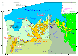
The coastal migration hypothesis is one of two leading hypotheses about the settlement of the Americas at the time of the Last Glacial Maximum. It proposes one or more migration routes involving watercraft, via the Kurile island chain, along the coast of Beringia and the archipelagos off the Alaskan-British Columbian coast, continuing down the coast to Central and South America. The alternative is the hypothesis solely by interior routes, which assumes migration along an ice-free corridor between the Laurentide and Cordilleran ice sheets during the Last Glacial Maximum.
The Keewatin ice sheet was a major ice sheet that periodically covered large parts of North America during glacial periods over the last ~2.6 million years. This included the following areas:
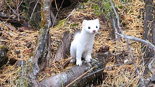
The Haida ermine is a mustelid species endemic to a few islands off the Pacific Northwest of North America, namely Haida Gwaii in Canada and the southern Alexander Archipelago in the U.S. state of Alaska.