City Canal

Last updated

City Canal
WestindiaviewofproposalWDaniell1802.jpg
An 1802 painting of the completed West India Docks. The City Canal is to the left of the painting. The view is looking west towards the City of London
Specifications
Locks2
Statusincorporated into docks
History
Date of act1799
Date of first use1805
Geography
Start point Isle of Dogs
Connects to River Thames
City Canal
BSicon uSTR.svg
River Thames, to London
BSicon uSTR+l.svg
BSicon uSTRq.svg
BSicon uSTRq.svg
BSicon uSTRq.svg
BSicon uFABZq+lr.svg
BSicon uSTRr.svg
Limehouse Reach
BSicon uSTR.svg
BSicon ugFGATEd.svg
Former West Lock
BSicon uSTR.svg
BSicon uSKRZ-Au.svg
A1206 Westferry
BSicon uSTR.svg
BSicon uDOCKSa.svg
BSicon uDOCKSa.svg
BSicon uSTRq.svg
West India Dock
BSicon uSTR.svg
BSicon uDOCKSe.svg
BSicon uDOCKSl.svg
BSicon uDOCKSr.svg
BSicon uSTRq.svg
BSicon uDOCKSe.svg
Millwall Dock
BSicon uSTR.svg
BSicon uFGATEu.svg
East Lock
BSicon uSTR.svg
BSicon uSKRZ-Au.svg
A1206 Prestons Road
BSicon uSTRl.svg
BSicon uSTRq.svg
BSicon uSTRq.svg
BSicon uSTRq.svg
BSicon uFABZqlr.svg
BSicon uSTR+r.svg
Blackwall Reach
BSicon uSTR.svg
River Thames, to estuary

The City Canal was a short, and short-lived, canal excavated across the Isle of Dogs in east London, linking two reaches of the River Thames. Today, it has been almost completely reconstructed to form the South Dock of the West India Docks.

Contents

History

The West India Docks Act of 1799 allowed the City of London Corporation to construct a canal from Limehouse Reach to Blackwall Reach, across the Isle of Dogs. [1] It was intended to provide a short cut for sailing ships, to save them travelling around the south of the Isle of Dogs to access the wharves in the upper reaches of the river. If winds were unfavourable, this journey could take some time. The idea had been suggested by Ralph Walker in 1796. The West India merchants employed him as an engineer, and with assistance from William Jessop, John Foulds and George Dance, who was the City of London's surveyor, he produced the detailed plans which enabled the Act of Parliament to be obtained. Jessop was appointed as engineer with Walker as resident engineer, in August 1799, but Walker departed in 1802 after a disagreement with Jessop following a structural failure of part of the works. [2] The canal was 3,710 feet (1,130 m) long with a surface width of 173 feet (53 m) and a depth of 45 feet (14 m). The two locks were 193 by 45 feet (59 by 14 m), with the floors built as inverted arches. The lock walls were 6 feet (1.8 m) thick, built of bricks with a stone facing. The depth over the lock cills varied between 20 and 24 feet (6.1 and 7.3 m) at high tide, allowing ships of up to 500 tons burden to use the canal. Banks 12 feet (3.7 m) high had to be built, because the high tide level was above that of the surrounding land, and the tops were 6 feet (1.8 m) above water level. The surrounding land also had to be raised to the same height. [3]

One of the major contractors was John Dyson Jr., who was based at Newington near Bawtry in South Yorkshire at the time. He was awarded a contract for excavation of the canal in 1800, and another for gravel extraction from 1801 to 1805. A third contract, for excavation of the west lock was awarded in 1803. He was working on the lock walls in December 1802, and had moved his family to Mile End by this date. [4] John Torr Foulds acted as assistant engineer for part of this period, from 1800 to 1802. [5] James Spedding was employed in 1805 to construct coffer dams to allow the wing walls at the ends of the canal to be built. A dam he had built in the previous year for the East India Dock had partially failed after four weeks, but had been repaired. The problem was one of design rather than bad workmanship, and the City Canal dam worked successfully. [6] The canal was completed in 1805 (officially opened on 9 December that year), having incorporated at its western end the Breach Dockyard, a mast and timber laying dock formed around a large linear pond. [7] The canal cost £168,813, including the acquisition of land. [8]

East Indiamen at City Canal, circa 1824 City Canal RMG PU7879.jpg
East Indiamen at City Canal, circa 1824

However, access to the canal was determined by the state of the tide and the transit slow. These factors meant the canal was not a financial success since the owners did not charge tolls. It soon became a liability and was sold, for £120,000, to the West India Dock Company, owner of the adjacent West India Docks, in 1829.

The company bought it mainly to prevent it from falling into other hands. Proposals for collier docks immediately south of the City Canal, and the opening of the St Katharine Docks in 1828, had heightened the company's awareness of the threat represented by other dock interests. [8] They added a timber dock to the south of the canal in 1832–3, the last major building work at the docks for 20 years. [8]

Some 30 years later (1866–70), in a scheme managed by engineer Sir John Hawkshaw, the canal was enlarged, the entrances were widened, and the complex was renamed the South West India Dock, [9] [10] later known as South Dock.

In 1926 it was decided that the South Dock should be connected to the West India import and export docks and to the Millwall Dock. [10] The developments - a new South Dock east entrance lock and three passages to link the Millwall, South, Export and Import Docks - were divided into four contracts, and were completed in 1931 at a final cost of £1,311,981 for the dock works, considerably improving access to the docks. [8]

Today

South Dock regularly plays host to medium-sized military vessels visiting London as it is the furthest point upstream that they can be turned around - courtesy of the reconstruction worked carried out in 1926-1931. There is no longer a route for vessels across the Isle of Dogs - only the reconstructed eastern entrance remains.

Bibliography

Related Research Articles

Isle of Dogs Area in the East End of London, England

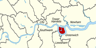
The Isle of Dogs is a large peninsula bounded on three sides by a large meander in the River Thames in East London, England, which includes the Cubitt Town, Millwall and Canary Wharf districts. The area was historically part of the Manor, Hamlet, Parish and, for a time, the wider borough of Poplar. The name had no official status until the 1987 creation of the Isle of Dogs Neighbourhood by Tower Hamlets London Borough Council. It has been known locally as simply "the Island" since the 19th century.

Poplar, London Area of East London, England

Poplar is a district in East London, England, the administrative centre of the borough of Tower Hamlets. Five miles (8 km) east of Charing Cross, it is part of the East End.

John Rennie the Elder Scottish civil engineer (1761–1821)

John Rennie FRSE FRS was a Scottish civil engineer who designed many bridges, canals, docks and warehouses, and a pioneer in the use of structural cast-iron.

River Hull River in the East Riding of Yorkshire, England

The River Hull is a navigable river in the East Riding of Yorkshire in Northern England. It rises from a series of springs to the west of Driffield, and enters the Humber Estuary at Kingston upon Hull. Following a period when the Archbishops of York charged tolls for its use, it became a free navigation. The upper reaches became part of the Driffield Navigation from 1770, after which they were again subject to tolls, and the section within the city of Hull came under the jurisdiction of the Port of Hull, with the same result.

Canary Wharf Major business and financial district in London, England

Canary Wharf is an area of London, England, located on the Isle of Dogs in the London Borough of Tower Hamlets. Canary Wharf is defined by the Greater London Authority as being part of London's central business district, alongside Central London. With the City of London, it constitutes one of the main financial centres in the United Kingdom and the world, containing many high-rise buildings including the fourth-tallest in the UK, One Canada Square, which opened on 26 August 1991.

West India Docks Historic dock site, now part of Canary Wharf area.

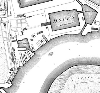
The West India Docks are a series of three docks, quaysides and warehouses built to import goods from and export goods and occasionally passengers to the British West Indies on the Isle of Dogs in London the first of which opened in 1802. Following their commercial closure in 1980, the Canary Wharf development was built around the wet docks by narrowing some of their broadest tracts.

Blackwall, London Area of the East End of London, England

Blackwall is an area of Poplar, in the London Borough of Tower Hamlets, East London. The neighbourhood includes Leamouth and the Coldharbour conservation area.

William Jessop British civil engineer (1745-1814)

William Jessop was an English civil engineer, best known for his work on canals, harbours and early railways in the late 18th and early 19th centuries.

Teddington Lock Series of locks on the River Thames in London

Teddington Lock is a complex of three locks and a weir on the River Thames between Ham and Teddington in the London Borough of Richmond upon Thames, England. Historically in Middlesex, it was first built in 1810.

Millwall Dock

Millwall Dock is a dock at Millwall, London, England, located south of Canary Wharf on the Isle of Dogs.

James Walker (engineer)

James Walker was an influential British civil engineer.

Josias Jessop (1781–1826) was a noted canal engineer, and second son of William Jessop, one of the great canal engineers of the late eighteenth and early nineteenth centuries. He was trained by his father, and worked under him on his early projects, but proved his abilities during the construction of Bristol harbour. He became an independent consulting engineer from 1811. He died fourteen years later, a little before he reached the age of 45.

East India Docks Historic docks in Blackwell, London

The East India Docks were a group of docks in Blackwall, east London, north-east of the Isle of Dogs. Today only the entrance basin and listed perimeter wall remain visible.

Grosvenor Canal Former canal in the Pimlico area of London

Grosvenor Canal was a canal in the Pimlico area of London, opened in 1824. It was progressively shortened, as first the railways to Victoria Station and then the Ebury Bridge housing estate were built over it. It remained in use until 1995, enabling barges to be loaded with refuse for removal from the city, making it the last canal in London to operate commercially. A small part of it remains among the Grosvenor Waterside development.

A1206 road (Great Britain)

The A1206, also known as the Isle of Dogs Distributor Road, is a crescent-shaped ring road around the Isle of Dogs, in the East End of London. It is made up of Westferry Road, Manchester Road and Prestons Road and is the main road through the area, connecting parts of the London Docklands.

Glasson Dock Human settlement in England

Glasson Dock, also known as Glasson, is a village in Lancashire, England, south of Lancaster at the mouth of the River Lune. In 2011, it had a population of around 600.

Coldharbour, Tower Hamlets

Coldharbour is a street and wider conservation area in Blackwall, lying on the north bank of the River Thames, east of Canary Wharf. The area is said to be "[t]he sole remaining fragment of the old hamlet of Blackwall" and "one of the last examples of the narrow streets which once characterised the river's perimeter".

Ralph Walker was a notable Scottish-born civil engineer in the late 18th and early 19th centuries, particularly associated with harbour engineering works in London.

Holderness Drain English water project

Holderness Drain is the main feature of a Land Drainage scheme for the area of Holderness to the east of the River Hull in the East Riding of Yorkshire, England. Construction began in 1764, and several notable civil engineers were involved with the scheme over the years. Despite the high costs of the initial scheme, it was not particularly successful, because of the refusal of the ship owners of Hull to allow an outlet at Marfleet. They insisted that the water be discharged into the River Hull to keep the channel free of silt. Following a period of agricultural depression and the building of new docks in the early 1800s, an outlet at Marfleet was finally authorised in 1832. A high level system still fed upland water to the Hull, but the low level system discharged into the Humber, where levels were considerably lower. Following the success of steam pumping on the Beverley and Barmston Drain, the trustees looked at such a possibility for the Holderness Drain, but the development of the Alexandra Dock in the 1880s and then the King George V Dock in 1913 provided a solution, as the docks were topped up with water pumped from the drain, to lessen the ingress of silt-laden water.

Blackwall Rock Reef in the River Thames

The Blackwall Rock was a reef in the River Thames in East London. The rock provided a useful shelter for moored vessels, but also proved a hazardous obstruction to river navigation. It was removed in the early 19th century following the opening of the adjacent West India Docks.

References

  1. Canals and distribution
  2. Skempton 2002 , p. 757
  3. Skempton 2002 , p. 370
  4. Skempton 2002, pp. 201–202.
  5. Skempton 2002, p. 235.
  6. Skempton 2002, p. 646.
  7. "Heritage". London Thames Gateway Forum. Archived from the original on 29 September 2007.
  8. 1 2 3 4 Hobhouse 1994 , pp. 248–68
  9. "West India Docks (1803-1980)". Port Cities. Archived from the original on 26 September 2007.
  10. 1 2 "Building the docks". Port Cities. Archived from the original on 22 December 2016.

Coordinates: 51°30′06″N0°01′01″W / 51.50167°N 0.01694°W / 51.50167; -0.01694