Former name(s) | Cashel Street and High Street |
---|---|
Maintained by | Christchurch City Council |
Width | 20 m |
Location | Christchurch Central City |
Coordinates | 43°31′57.28″S172°38′14.69″E / 43.5325778°S 172.6374139°E Coordinates: 43°31′57.28″S172°38′14.69″E / 43.5325778°S 172.6374139°E |
Construction | |
Construction start | 1982 |
Inauguration | 7 August 1982 |
City Mall is the main pedestrian mall in the central city of Christchurch, New Zealand, comprising two sections of Cashel Street plus the Bridge of Remembrance and one section of High Street. It is also known colloquially as Cashel Mall. [1] [2] [3] [4] The Bridge of Remembrance was pedestrianised in 1976. The main mall was closed to traffic on 11 January 1982 and formally reopened as a pedestrian mall on 7 August, but it was not until 1992 that the entire mall was paved. The mall was redeveloped between 2006 and 2009, and track was installed for an expansion of the heritage tram network.
The September 2010 Canterbury earthquake caused damage to some buildings, but the Boxing Day aftershock, directly underneath the city, caused even more damage, including building failures. The 6.3 magnitude February 2011 Christchurch earthquake devastated the mall; the façades of many buildings collapsed and there were several fatalities. The centre of the city was subsequently closed to allow demolition work to proceed. Structures affected included most of the heritage buildings in the mall that are or were registered by Heritage New Zealand. Part of City Mall, the section of Cashel Street from Oxford Terrace to Colombo Street, was the first part of the central city to open again, on Saturday, 29 October 2011, marked by a ceremony at which the Prime Minister John Key officiated.
City Mall is made up of Cashel Street between Cambridge Terrace up to its intersection with High Street and High Street from Cashel Street to its intersection with Hereford and Colombo Streets. [5]
Cashel Street runs east-west. The portion of Cashel Street that makes up City Mall is approximately 400 metres (1,300 ft) long. The street is named after the bishopric of Cashel. At the time of naming by surveyor Edward Jollie and Joseph Thomas, the bishop was Robert Daly, an uncle of John Robert Godley, who is considered to be the founder of Canterbury. [6] [7]
High Street is one of the two diagonal streets in the central city, running from north-west to south-east. The portion of High Street that makes up City Mall is approximately 150 metres (490 ft) long. It was initially called Sumner Road, as it connected to the village (and later suburb) of Sumner. It was renamed Lower High Street, and then just High Street, probably after The High in Oxford. [8]
The Canterbury/Westland Branch of the New Zealand Institute of Valuers began biannual pedestrian counts in central Christchurch in 1957. The count takes place one hour in the morning and afternoon, respectively (10:30h to 11:30h and 14:30h to 15:30h). While dozens of sites are counted, only seven of the locations have been included in the count since the work began in the 1950s. There is a gradual but steady decline visible in pedestrian numbers. The seven sites had 30,000 pedestrians in 1957, and that had reduced to 18,000 by the 1981 count. The establishment of City Mall saw the numbers increase to 25,000 again, but the overall downward trend continued after that, albeit starting at the higher level of the 1983 count. [9]
The concept of a pedestrian mall in Cashel and High Streets was first developed in the 1965 central city redevelopment study. [5] In the same year, there were proposals in Wellington to form a pedestrian mall in Cuba Street. [10] The Christchurch concept was included in the 1968 District Scheme (a predecessor of the Christchurch City Plan). [5] A year later, Cuba Mall was established in Wellington, the success of which gave other cities the confidence to advance their plans for pedestrianising streets. [10] In 1976, the Bridge of Remembrance was closed to traffic, reserving the short Cashel Street link between Oxford and Cambridge Terraces over the Avon River for pedestrians. [11] The plans for City Mall were confirmed in the 1979 review of the District Scheme. A concept design by the City Architect was adopted by Christchurch City Council, the Cashel Street Businessmen's Association and the High Street Businessmen's Association in 1981. [5]
On 11 January 1982, the sections of Cashel and High Street that form the mall were closed to traffic. Mayor Hamish Hay opened the NZ$0.5m City Mall project on 7 August 1982. [5] It took ten years and three separate project stages before the whole area was paved; [12] tree planters and additional seating were installed as part of the final project stage in the early 1990s. Mayor Vicki Buck opened the third and final stage on 4 December 1992. [5]
In 1998, Christchurch City Council redeveloped the adjacent section of Oxford Terrace, which became known as The Strip, and narrowed the road to a one-way street. It was the prime night-time entertainment hub in Christchurch over the next decade, until increasing competition from newer developments took its toll. [9] [13] Another pedestrian mall in Christchurch inspired by City Mall was New Regent Street, which was closed to traffic in 1994 in preparation for the reintroduction of the Christchurch tram. [14]
During 2006, the public were invited to comment on the proposed redevelopment plans for City Mall. The Council approved the final proposals in December 2006 and agreed an implementation plan, for which NZ$10.5 million had been budgeted, [15] but on which NZ$14 million was spent. [16] An alliance contract was entered into between Christchurch City Council as the client, Isthmus Group as the designer, and Downer EDI Works as the contractor. [15] Mayor Garry Moore and Central City Business Association chairman Antony Gough started the work with a symbolic lifting of the first brick on 10 August 2007. [17]
A separate project that affected the City Mall redevelopment was the extension of the heritage tramway. From the previous circuit on Worcester Street, the extension would see the trams turn left into Oxford Terrace (The Strip), and then left into the Cashel Street part of City Mall. At the intersection with High Street, trams would turn south-east towards Lichfield Street. On the return journey, trams would travel north-west along High Street, including the City Mall part of it. The $10.8 million project, to be funded from grants and from borrowing, was due to be completed in the 2013/14 financial year. [18]
The redevelopment was not without controversy. Young people protested strongly about the demolition of Hack Circle on the corner of Cashel and High Streets, as it was seen as an attempt to push them out of City Mall. Antony Gough, owner of several properties along The Strip, [19] was an advocate of stronger security for City Mall, particularly the Hack Circle, telling The Press that the people who associate there "are just very scary". [20] Police arrested several young people during the mall redevelopment, including 13 teenagers when the demolition of Stewart Fountain began. [21] [22]
The second Stewart Fountain, replacing an earlier fountain, was built in 1998 at a cost of NZ$700,000, with a NZ$200,000 contribution by industrialist Sir Robertson Stewart and decorated with hundreds of tiles painted by Christchurch schoolchildren. Demolition of the fountain began on 13 August 2007 and 13 young people were arrested in the resulting demonstration; Sir Robertson Stewart had died that morning. [22] [23] Christchurch City Council formally named the reserve Stewart Plaza in 2008. Stewart's bequest part-funded the replacement sculpture, "Flour Power", on the condition that the installation be permanent, and that the land be known as Stewart Plaza. [24]
Another controversial issue was the slow road through High Street. Despite opposition from 70% of those who had taken part in the public consultation, the Council confirmed that the slow road would go ahead. [25] The upgraded City Mall was opened by mayor Bob Parker on 18 December 2009. [16]
The central city was closed for a week after the 7.1 magnitude earthquake on 4 September 2010; some buildings were damaged, including parapets collapsing. The central city experienced peak ground acceleration (i.e. earthquake intensity) of between 15% and 20% of gravity. [26] Ongoing aftershocks and cracked building façades dented confidence in the central city. Retailers in the City Mall retailers had put an effort into strongly promoting the traditional Boxing Day sales in 2010, and there was "brisk trade" until an aftershock at 10.30 am. Although only a 4.9 magnitude earthquake, its epicentre was directly beneath the central city and the resulting peak ground acceleration ranged from 22% of gravity at ChristChurch Cathedral and 48% at Christchurch Botanic Gardens. [26] [27] The Last Train to India restaurant at 94 Cashel Street was a graphic example of the damage caused. The wall of the adjacent former Zetland Hotel collapsed and crashed through the roof; anybody standing in the restaurant's bar area would likely have been killed, but it was still closed that morning. [28] [29]
Damage caused by the 22 February 2011 Christchurch earthquake was much more severe. Although its 6.3 magnitude was lower than the September 2010 event, it was much closer to the central city and caused the loss of many buildings. The peak ground acceleration reached 180% of gravity in the city. [30] Four people died in Cashel Street in the section between Oxford Terrace and Colombo Street, and one person died in the High Street part of City Mall, all of them killed by falling masonry. [31] The central city was cordoned off on 22 February while demolitions were underway. [32] [33]
In April 2011, it was announced that part of Cashel Street was to reopen on 29 October 2011. [34] Temporary shops made from shipping containers were fitted out as retail premises, accommodating 27 shops known as Re:START. [35] Ballantynes, Christchurch's remaining department store, also reopened and is the retail anchor. Prime Minister John Key officiated at the opening ceremony. [36]
Organisers initially claimed that it was the world first pop-up mall, [37] [38] but there were already container malls in other places, for example Cholula (Mexico) and Bishkek (Kyrgyzstan). Organisers of the Christchurch mall project were threatened with legal action by organisers of a similar project in London (Boxpark) that was yet to open. [39]
The Canterbury Earthquake Recovery Authority completed the removal of the Red Zone cordon, including removing the remaining cordon around City Mall, in June 2013. [40]
City Mall contains or contained seven structures that are or were registered as historic places by Heritage New Zealand. The following table lists these buildings starting at the Colombo / Hereford / High intersection and proceeding down High Street and then along Cashel Street:
Photo | Name | Category | Status | Address | Description |
Fisher's Building | I | Demolished | 280 High Street | Commercial building designed by William Armson [41] | |
D.I.C. Building | II | Demolished | 154–158 Cashel Street | Former department store building from 1909 [42] | |
Beaths Department Store Building | II | Still standing | 682–690 Colombo Street; corner Cashel Street | Part of the Bus Exchange as of 2011 [43] | |
Guthrey Centre | I | Demolished | 124–126 Cashel Street | Commercial building from ca. 1881 designed by William Armson [44] | |
Twentymen & Cousins Store | II | Demolished | 93 Cashel Street | Commercial building from 1882 [41] | |
Zetland Hotel | II | Demolished | 88–92 Cashel Street | Former hotel from 1903; [41] the Last Train to India restaurant is in the low rise on the left | |
Bridge of Remembrance | I | Repairs completed April 2016 | Between Oxford and Cambridge Terraces | World War I war memorial [11] |
Christchurch is the largest city in the South Island of New Zealand and the seat of the Canterbury Region. Christchurch lies on the South Island's east coast, just north of Banks Peninsula on Pegasus Bay. The Avon River / Ōtākaro flows through the centre of the city, with an urban park along its banks. The city's territorial authority population is 389,300 people, and includes a number of smaller urban areas as well as rural areas. The population of the urban area is 377,900 people. Christchurch is the second-largest city by urban area population in New Zealand, after Auckland. It is the major urban area of an emerging sub-region known as Greater Christchurch. Notable smaller urban areas within this sub-region include Rangiora and Kaiapoi in Waimakariri District, north of the Waimakariri River, and Rolleston and Lincoln in Selwyn District to the south.
Cathedral Square, locally known simply as the Square, is the geographical centre and heart of Christchurch, New Zealand, where the city's Anglican cathedral, ChristChurch Cathedral is located. The square stands at the theoretical crossing of the city's two main orthogonal streets, Colombo Street and Worcester Street, though in practice both have been either blocked off or detoured around the square itself. The cathedral was badly damaged in the February 2011 Christchurch earthquake.
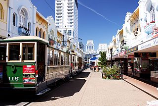
The Christchurch tramway system was an extensive network in Christchurch, New Zealand, with steam and horse trams from 1882. Electric trams ran from 1905 to 1954, when the last line from Cashmere to Papanui was replaced by buses.
Christchurch Central City or Christchurch City Centre is the geographical centre and the heart of Christchurch, New Zealand. It is defined as the area within the Four Avenues and thus includes the densely built up central city, some less dense surrounding areas of residential, educational and industrial usage, and green space including Hagley Park, the Christchurch Botanic Gardens and the Barbadoes Street Cemetery.
The 2010 Canterbury earthquake struck the South Island of New Zealand with a moment magnitude of 7.1 at 4:35 am local time on 4 September, and had a maximum perceived intensity of X (Extreme) on the Mercalli intensity scale. Some damaging aftershocks followed the main event, the strongest of which was a magnitude 6.3 shock known as the Christchurch earthquake that occurred nearly six months later on 22 February 2011. Because this aftershock was centred very close to Christchurch, it was much more destructive and resulted in the deaths of 185 people.
Manchester Courts, earlier known as the MLC Building, was a commercial high-rise building in the Christchurch Central City. Built in 1905–1906 for the New Zealand Express Company, it was at the time the tallest commercial building in Christchurch. A Category I heritage building, it suffered serious structural damage in the 2010 Canterbury earthquake and was condemned to be demolished. Demolition began on 19 October, and was completed in February 2011.
Colombo Street is a main road of the city of Christchurch, New Zealand. It runs south-north through the centre of Christchurch with a break at Cathedral Square. As with many other central Christchurch streets, it is named for a colonial Anglican bishopric, Colombo, Sri Lanka in what at the time was known as Ceylon. Parts of the street which run through Sydenham were known as Addison Street during the 1880s, and some parts were known as Colombo Road.
The Hotel Grand Chancellor was a major four-star hotel in the centre of Christchurch in New Zealand, one of eleven Hotel Grand Chancellor establishments across Australia and New Zealand. The hotel was located at 161 Cashel Street, close to the city's City Mall central shopping precinct.
The Bridge of Remembrance is one of two main war memorials in Christchurch, New Zealand. It is dedicated to those who died in World War I, and serves as a memorial for those who participated in two World Wars as well as subsequent conflicts in Borneo, Korea, Malaya, and Vietnam. Owned by Christchurch City Council, it is located on the Cashel Street Bridge at the head of City Mall. The Bridge of Remembrance was repaired and strengthened following the 2011 Christchurch earthquake and was reopened with a rededication ceremony held on Anzac Day in 2016.
St Paul's Church in Cashel Street, Christchurch, was a Category I heritage building registered by the New Zealand Historic Places Trust. It was demolished after the February 2011 Christchurch earthquake.
The Octagon, Christchurch, the former Trinity Church or Trinity Congregational Church designed by Benjamin Mountfort, later called the State Trinity Centre, is a Category I heritage building listed with Heritage New Zealand. Damaged in the 2010 Canterbury earthquake and red-stickered after the February 2011 Christchurch earthquake, the building was threatened with demolition like most other central city heritage buildings. In June 2012, it was announced that the building will be saved, repaired and earthquake strengthened.
The Central City Red Zone, also known as the CBD Red Zone, was a public exclusion zone in the Christchurch Central City implemented after the 22 February 2011 Christchurch earthquake. After February 2013, it was officially renamed the CBD Rebuild Zone by government agencies, but remained known as the Red Zone. It gradually shrank in size and the last cordons were removed on 30 June 2013, 859 days after the earthquake.
The Westpac Canterbury Centre was a landmark tower on the corner of High Street and Cashel Street in the center of Christchurch, New Zealand. Prior to the February 2011 earthquake, it was considered the 9th tallest building in Christchurch, standing at 55 meters tall.
The Christchurch Central Police Station was the former headquarters of the Canterbury Police District. Once the tallest building in Christchurch, New Zealand, it was damaged in the 2011 Christchurch earthquake and demolished by implosion on 31 May 2015.
Container Mall was a temporary mall built from shipping containers in Christchurch Central City, New Zealand. It had been a response to the 22 February 2011 Christchurch earthquake, which destroyed most buildings in City Mall, and resulted in the central city being cordoned off from public access while buildings were being demolished. Initially considered a short-term response to the lack of permanent buildings, Re:START was popular with locals and tourists alike and remained open for business until January 2018.
An earthquake occurred in Christchurch on 14 February 2016 at 1:13 p.m. local time and initially recorded as 5.9 on the Richter scale, but subsequently reviewed as 5.7. Often referred to as the Valentine's Day earthquake, it was centred in the sea off New Brighton at a depth of 15 kilometres (9.3 mi). It was the first large earthquake that the Christchurch area had experienced since May 2012, and it was part of the earthquake sequence that started with the 4 September 2010 Canterbury earthquake.
New Regent Street is a pedestrian mall in Christchurch. Built as a private development in the early 1930s with 40 shops in Spanish Mission architectural style, it is one of the city's major tourist attractions. Providing a number of small shops as a comprehensive development was an advanced idea at the time, and New Regent Street is regarded as a forerunner to modern shopping malls. Due to its coherent architectural character, the buildings in the streets are listed as Category I heritage items by Heritage New Zealand, and in addition, the entire street has a historic area listing. The street was pedestrianised in 1994 in preparation for the introduction of the Christchurch heritage tram, which began operation in February 1995. Damaged in the February 2011 Christchurch earthquake, the street and buildings reopened in April 2013, and the tram returned from November of that year. Following the 2016 Valentine's Day earthquake, five of the buildings that had not been repaired after the previous earthquakes have been cordoned off, which stopped the tram from operating on its original heritage loop until May.
Christchurch Central Library was a library in Central Christchurch and the main library of Christchurch City Libraries, New Zealand. It was the largest library in the South Island and the third-biggest in New Zealand. It opened in 1982 on the corner of Oxford Terrace and Gloucester Street but was closed on the day of the 22 February 2011 Christchurch earthquake. The building was demolished in 2014 to make way for the Convention Centre Precinct. The replacement library, Tūranga, opened in 2018.
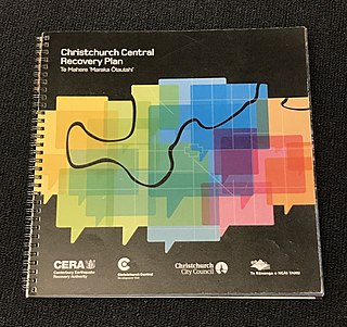
The Christchurch Central Recovery Plan, often referred to as the Blueprint, is the plan developed by the Fifth National Government of New Zealand for the recovery of the Christchurch Central City from a series of earthquakes, in particular the February 2011 Christchurch earthquake. The Canterbury Earthquake Response and Recovery Act 2010 required the Christchurch City Council to develop a recovery plan for the central city. The plan, known as Share an Idea, was presented to the Minister for Canterbury Earthquake Recovery, Gerry Brownlee, in December 2011. Brownlee rejected the city council's plan, established the Canterbury Earthquake Recovery Authority (CERA), and tasked that organisation with developing a plan based on the city council's draft. The Christchurch Central Recovery Plan was published in July 2012 and defined 17 anchor projects. All projects where a timeline was specified were to have been finished by 2017; none of the 17 projects have been delivered on time and some have not even been started yet.
Worcester Street is a road in the central city of Christchurch, New Zealand. It runs from the intersection of Rolleston Avenue in the west, and terminates in the east at the intersection of Woodham Road in Linwood. Between Rolleston Avenue and Cambridge Terrace, it is known as Worcester Boulevard.