1855 Wairarapa earthquake

Last updated

1855 Wairarapa earthquake
New Zealand (relief map).png
Bullseye1.png
Local date23 January 1855 (1855-01-23)
Local time21:00
Magnitude8.2 Mw
Depth33 km
Epicentre 41°12′S175°12′E / 41.20°S 175.20°E / -41.20; 175.20
Areas affectedNew Zealand, North Island
Casualties7–9 deaths

The 1855 Wairarapa earthquake occurred on 23 January at about 9.17 p.m., [1] affecting much of the Cook Strait area of New Zealand, including Marlborough in the South Island and Wellington and the Wairarapa in the North Island. In Wellington, close to the epicentre, shaking lasted for at least 50 seconds. The moment magnitude of the earthquake has been estimated as 8.2, the most powerful recorded in New Zealand since systematic European colonisation began in 1840. [2] This earthquake was associated with the largest directly observed movement on a strike-slip fault, maximum 18 metres (59 ft). This was later revised upward to about 20 m (66 ft) slip, with a local peak of 8 m (26 ft) vertical displacement on lidar studies. [3] It has been suggested that the surface rupture formed by this event helped influence Charles Lyell to link earthquakes with rapid movement on faults. [4]

Contents

Tectonic setting

New Zealand lies along the boundary between the Australian and Pacific Plates. In the South Island most of the relative displacement between these plates is taken up along a single dextral (right lateral) strike-slip fault with a major reverse component, the Alpine Fault. In the North Island the displacement is mainly taken up along the Kermadec subduction zone, although the remaining dextral strike-slip component of the relative plate motion is accommodated by the North Island Fault System (NIFS). [5] A group of dextral strike-slip structures, known as the Marlborough Fault System, transfer displacement between the mainly transform and convergent type plate boundaries in a complex zone at the northern end of the South Island. [6] The earthquake occurred on the Wairarapa Fault which is part of the NIFS.

Earthquake characteristics

Map of the North Island Fault System showing the Wairarapa Fault NIFS.png
Map of the North Island Fault System showing the Wairarapa Fault

The earthquake was associated with the rupturing of approximately 150 km (93 mi) of the Wairarapa Fault. A horizontal displacement of up to 18 metres (59 ft) was accompanied by uplift and tilting of the Rimutaka Range on the northwestern side of the fault with vertical offsets of about 6 metres near the fault reducing to almost nothing on the western coast of the Wellington Peninsula. The estimated magnitude of about 8.2 is unusually large for an earthquake associated with movement on a mainly strike-slip fault, and the coseismic offset would have been the largest known for such an event. It has been suggested that this was caused by the rupture propagating down to where the fault links through to the top of the subducting Pacific Plate. [7] That such megathrust coupling with overlying surface faults is possible was subsequently observed with the 2016 Kaikōura earthquake, and a new model for a subset of shallow megathrust earthquakes, including this earthquake, was developed. [8] Other evidence for this hypothesis is geomorphological evidence, particularly the uplifted beach ridges observed at Turakirae Head, that appear to record three previous coseismic uplifts of the Rimutaka Range caused by earthquakes similar in magnitude to the 1855 event, with a recurrence interval of about 2200 years. [9]

At least ten large earthquakes were identified along the fault during the Holocene. Three of the most recent, including the 1855 earthquake, produced average slips of 16.5 m (54 ft) ± 2.2 m (7 ft 3 in). The unusually large slip to rupture length ratio meant the earthquake would have been a high stress drop, hence, energetic event. This may be possibly attributed to the geologically young nature of the fault, being about 1 to 3 million years old, making it an immature structure. Faults in their early developmental stage have been observed to generate earthquakes with the most greatest stress drop and strong ground motion. [10]

Damage

1855 painting of landslip near Newlands by Charles Emilius Gold Landslip caused by earthquake near Wellington.jpg
1855 painting of landslip near Newlands by Charles Emilius Gold

Wellington experienced severe shaking but the resulting damage was reduced as the city had been extensively rebuilt following the 1848 Marlborough earthquake using mainly wooden structures; [11] only one recorded fatality (by collapse of a brick chimney) occurred, though several other buildings were damaged. Reports identify at least another four people (possibly as many as eight) as having died in the Wairarapa during the earthquake and a bridge over the Hutt River was wrecked. [1] Numerous landslides were associated with the earthquake, [12] including the harbour-side cliffs near Newlands [13] [14] and numerous events along the slopes of the Rimutaka Range. Minor damage was recorded in places as far away as New Plymouth, [1] Lyttelton and Christchurch.

The uplift of the northwestern side of Wellington Harbour rendered many of the jetties in the harbour unusable, although this new area of land provided a new rail and road route to the north. Much of modern Wellington's central business district is formed by reclamations on land raised from the harbour by the event, as shown by the series of "Shoreline 1840" plaques. [15] [16] At Turakirae Head the newest raised beach was formed by an uplift of 6.4 m (21 ft) in the 1855 quake. [17]

Along with other historic earthquakes in the Wellington region, the severe uplift and landslides along the coastline caused by the 1855 Wairarapa earthquake would have likely extirpated local populations of Durvillaea antarctica southern bull kelp. [18] [19] For comparison, a large-scale die off of Durvillaea was observed following the 2016 Kaikōura earthquake. [20] [21] [22] [23] [24] The removal of D. antarctica along the Wellington coastline in 1855 (or earlier) would have created an ecological opportunity, which may have facilitated a northward range expansion for Durvillaea poha from the South Island. [18]

Tsunami

The earthquake generated New Zealand's largest historical locally generated tsunami, with a maximum run-up of 10–11 m (33–36 ft). [25] [26] New Zealand's National Institute of Water and Atmospheric Research created an animated tsunami simulation model based on the 1855 Wairarapa event, which was screened on the television tele-drama "Aftershock". [27]

See also

Related Research Articles

<span class="mw-page-title-main">Turakirae Head</span>

Turakirae Head is a promontory on the southern coast of New Zealand's North Island. It is located at the western end of Palliser Bay, 20 kilometres southeast of Wellington, at the southern end of the Remutaka Range. The head hosts a series of uplifted Holocene marine terraces and beach ridges that record uplift from past earthquakes. After each earthquake, a new terrace and beach ridge formed below the previous one at sea level. The most recent earthquake to uplift Turakirae Head was the 1855 Wairarapa earthquake, which raised the shoreline up to 6.4 m. Turakirae Head is also home to a seal colony and southern bull kelp.

Megathrust earthquakes occur at convergent plate boundaries, where one tectonic plate is forced underneath another. The earthquakes are caused by slip along the thrust fault that forms the contact between the two plates. These interplate earthquakes are the planet's most powerful, with moment magnitudes (Mw) that can exceed 9.0. Since 1900, all earthquakes of magnitude 9.0 or greater have been megathrust earthquakes.

<i>Durvillaea</i> Genus of seaweeds

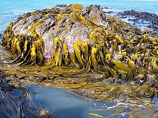
Durvillaea is a genus of large brown algae in the monotypic family Durvillaeaceae. All members of the genus are found in the southern hemisphere, including Australia, New Zealand, South America, and various subantarctic islands. Durvillaea, commonly known as southern bull kelps, occur on rocky, wave-exposed shorelines and provide a habitat for numerous intertidal organisms. Many species exhibit a honeycomb-like structure in their fronds that provides buoyancy, which allows individuals detached from substrates to raft alive at sea, permitting dispersal for hundreds of days over thousands of kilometres. Durvillaea species have been used for clothing, tools and as a food source by many indigenous cultures throughout the South Pacific, and they continue to play a prominent role in Chilean cuisine.

<i>Durvillaea willana</i> Species of seaweed

Durvillaea willana is a large species of southern bull kelp endemic to New Zealand.

<span class="mw-page-title-main">Nankai megathrust earthquakes</span> Class of earthquakes in Japan

Nankai megathrust earthquakes are great megathrust earthquakes that occur along the Nankai megathrust – the fault under the Nankai Trough – which forms the plate interface between the subducting Philippine Sea Plate and the overriding Amurian Plate, which dips beneath southwestern Honshu, Japan. The fault is divided into five segments in three zones, which rupture separately or in combination, and depending on location, the resulting earthquakes are subdivided by zone from west to east into Nankai earthquakes, Tōnankai earthquakes, and Tōkai earthquakes.

The 1888 North Canterbury earthquake occurred at 4:10 am on 1 September following a sequence of foreshocks that started the previous evening, and whose epicentre was in the North Canterbury region of the South Island of New Zealand. The epicentre was approximately 35 kilometres (22 mi) west of Hanmer.

Seismotectonics is the study of the relationship between the earthquakes, active tectonics and individual faults of a region. It seeks to understand which faults are responsible for seismic activity in an area by analysing a combination of regional tectonics, recent instrumentally recorded events, accounts of historical earthquakes and geomorphological evidence. This information can then be used to quantify the seismic hazard of an area.

The 1848 Marlborough earthquake was a 7.5 earthquake that occurred at 1:40 a.m. on 16 October 1848 and whose epicentre was in the Marlborough region of the South Island of New Zealand.

The 1843 Whanganui earthquake occurred on 8 July at 16:45 local time with an estimated magnitude of 7.5 on the Mw scale. The maximum perceived intensity was IX (Violent) on the Mercalli intensity scale, and possibly reaching X (Extreme). The epicentre is estimated to have been within a zone extending 50 km northeast from Whanganui towards Taihape. GNS Science has this earthquake catalogued and places the epicentre 35 km east of Taihape, near the border of Hawke's Bay. This was the first earthquake in New Zealand over magnitude 7 for which written records exist, and the first for which deaths were recorded.

<span class="mw-page-title-main">1861 Sumatra earthquake</span> Natural disaster in Indonesia

The 1861 Sumatra earthquake occurred on 16 February and was the last in a sequences of earthquakes that ruptured adjacent parts of the Sumatran segment of the Sunda megathrust. It caused a devastating tsunami which led to several thousand fatalities. The earthquake was felt as far away as the Malay peninsula and the eastern part of Java. The rupture area for the 2005 Nias–Simeulue earthquake is similar to that estimated for the 1861 event.

<span class="mw-page-title-main">Marlborough fault system</span> Active fault system in New Zealand

The Marlborough fault system is a set of four large dextral strike-slip faults and other related structures in the northern part of South Island, New Zealand, which transfer displacement between the mainly transform plate boundary of the Alpine fault and the mainly destructive boundary of the Kermadec Trench, and together form the boundary between the Australian and Pacific Plates.

<span class="mw-page-title-main">Clarence Fault</span> Active fault in New Zealand

The Clarence Fault is an active dextral strike-slip fault in the northeastern part of South Island, New Zealand. It forms part of the Marlborough Fault System, which accommodates the transfer of displacement along the oblique convergent boundary between the Indo-Australian Plate and Pacific Plate, from the transform Alpine Fault to the Hikurangi Trench subduction zone.

<span class="mw-page-title-main">North Island Fault System</span> Fault zone of the east coast of New Zealands North Island

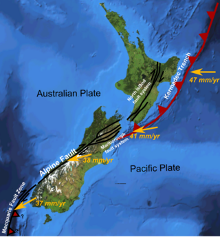
The North Island Fault System (NIFS) is a set of southwest–northeast trending seismically-active faults in the North Island of New Zealand that carry much of the dextral strike-slip component of the oblique convergence of the Pacific Plate with the Australian Plate. However despite at least 3 km (1.9 mi) of uplift of the axial ranges in the middle regions of the fault system during the last 10 million years most of the shortening on this part of the Hikurangi Margin is accommodated by subduction.

<span class="mw-page-title-main">Wairarapa Fault</span> Active seismic fault in New Zealand

The Wairarapa Fault is an active seismic fault in the southern part of the North Island of New Zealand. It is a dextral strike-slip fault with a component of uplift to the northwest as expressed by the Rimutaka Range. It forms part of the North Island Fault System, which accommodates the transfer of displacement along the oblique convergent boundary between the Indo-Australian Plate and Pacific Plate.

<span class="mw-page-title-main">Wellington Fault</span> Active seismic fault in New Zealand

The Wellington Fault is an active seismic fault in the southern part of the North Island of New Zealand. It is a dextral (right-lateral) strike-slip fault with variable amounts of vertical movement causing uplift to the northwest, as expressed by a series of ranges. It forms part of the North Island Fault System, which accommodates the transfer of displacement along the oblique convergent boundary between the Indo-Australian Plate and Pacific Plate.

The 2002 Sumatra earthquake occurred at 01:26 UTC on 2 November. It had a magnitude of 7.4 on the moment magnitude scale with an epicenter just north of Simeulue island and caused three deaths. This earthquake is regarded as a foreshock of the 2004 Indian Ocean earthquake, which had an epicenter about 60 km to the northwest.

<span class="mw-page-title-main">2016 Kaikōura earthquake</span> 2016 earthquake in central New Zealand

The 2016 Kaikōura earthquake was a magnitude 7.8 (Mw) earthquake in the South Island of New Zealand that occurred two minutes after midnight on 14 November 2016 NZDT. Ruptures occurred on multiple faults and the earthquake has been described as the "most complex earthquake ever studied". It has been subsequently modelled as having a megathrust component set off by an adjacent rupture on the Humps Fault. It was also the second largest earthquake since European settlement.

<span class="mw-page-title-main">Kekerengu Fault</span> Active fault in New Zealand

The Kekerengu Fault is an active dextral strike-slip fault in the northeastern part of South Island, New Zealand. It is closely associated with the Hope Fault and Jordan Thrust at its south-easternmost edge and likely joins with the Clarence Fault to form the Wairarapa Fault offshore in Cook Strait.

<span class="mw-page-title-main">2021 Chignik earthquake</span> 7th largest earthquake in the US

An earthquake occurred off the coast of the Alaska Peninsula on July 28, 2021, at 10:15 p.m. local time. The large megathrust earthquake had a moment magnitude of 8.2 according to the United States Geological Survey (USGS). A tsunami warning was issued by the National Oceanic and Atmospheric Administration (NOAA) but later cancelled. The mainshock was followed by a number of aftershocks, including three that were of magnitude 5.9, 6.1 and 6.9 respectively.

References

  1. 1 2 3 "NEW ZEALANDER". paperspast.natlib.govt.nz. 28 February 1855. Retrieved 24 March 2022.
  2. M 8.2 Wairarapa Tue, Jan 23 1855. GeoNet.
  3. Manighetti, I; Perrin, C; Gaudemer, Y; Dominguez, S; Stewart, N; Malavieille, J; Garambois, S (2020). "Repeated giant earthquakes on the Wairarapa fault, New Zealand, revealed by Lidar-based paleoseismology". Scientific Reports. 10 (2124): 2124. Bibcode:2020NatSR..10.2124M. doi:10.1038/s41598-020-59229-3. PMC   7005692 . PMID   32034264.
  4. Sibson, R.H. (2006). "Charles Lyell and the 1855 Wairarapa earthquake in New Zealand: Recognition of fault rupture accompanying an earthquake". Seismological Research Letters. 77 (3): 358–363.
  5. Mouslopoulou, V., Nicol, A., Little, T.A. & Walsh, J.J. (2007). "Terminations of large strike-slip faults: an alternative model from New Zealand". In: Cunningham, W.D. & Mann, P (eds). Tectonics of Strike-Slip Restraining and Releasing Bends. Geological Society of London, Special Publication, 290; p. 387–415.
  6. Van Dissen, R. & Yeats, R.S. (1991). "Hope Fault, Jordan Thrust, and uplift of the Seaward Kaikoura Range, New Zealand". Geology, 19, 393–396.
  7. Rodgers, D.W.; Little T.A. (2006). "World's largest coseismic strike-slip offset: The 1855 rupture of the Wairarapa Fault, New Zealand, and implications for displacement/length scaling of continental earthquakes". Journal of Geophysical Research. 111 (B12408): B12408. Bibcode:2006JGRB..11112408R. doi:10.1029/2005JB004065.[ permanent dead link ]
  8. Herman, MW; Furlong, KP; Benz, HM (2023). "Substantial Upper Plate Faulting Above a Shallow Subduction Megathrust Earthquake: Mechanics and Implications of the Surface Faulting During the 2016 Kaikoura, New Zealand, Earthquake". Tectonics. 42 (5): e2022TC007645. Bibcode:2023Tecto..4207645H. doi: 10.1029/2022TC007645 .
  9. McSaveney, M.J.; Graham, I.J.; Begg, J.G.; Beu, A.G.; Hull, A.G.; Kyeong, K. & Zondervan, A. (2006). "Late Holocene uplift of beach ridges at Turakirae Head, south Wellington coast, New Zealand". New Zealand Journal of Geology and Geophysics. 49 (3): 337–358. Bibcode:2006NZJGG..49..337M. doi: 10.1080/00288306.2006.9515172 . S2CID   129074978.
  10. Manighetti, I.; Perrin, C.; Gaudemer, Y.; Dominguez, S.; Stewart, N.; Malavieille, J.; Garambois, S. (2020). "Repeated giant earthquakes on the Wairarapa fault, New Zealand, revealed by Lidar-based paleoseismology". Scientific Reports. 10 (2124): 2124. Bibcode:2020NatSR..10.2124M. doi:10.1038/s41598-020-59229-3. PMC   7005692 . PMID   32034264.
  11. "The Earthquake of 1855", Early Wellington, 1928, Louis E. Ward
  12. Hancox, Graham (September 2005). "Landslides and liquefaction effects caused by the 1855 Wairarapa earthquake: then and now". In Townend, John; Langridge, Rob; Jones, Andrew (eds.). The 1855 Wairarapa Earthquake Symposium. Greater Wellington Regional Council. pp. 84–94. ISBN   0-909016-87-9.
  13. "GeoNet M 8.2 Wairarapa Tue, Jan 23 1855 - story". www.geonet.org.nz. Retrieved 24 March 2022.
  14. "Hutt Expy". Google Maps. February 2015. Retrieved 24 March 2022.
  15. Jackson, Amy (2 November 2012). "How quakes shook up the shore". Stuff. Retrieved 24 November 2018.
  16. "Massive earthquake hits southern North Island". nzhistory.govt.nz. Ministry for Culture and Heritage. Retrieved 24 November 2018.
  17. Homer, Lloyd (1 March 2016). "Raised beaches, Turakirae Head". teara.govt.nz. Retrieved 24 March 2022.
  18. 1 2 Vaux, Felix; Craw, Dave; Fraser, Ceridwen I.; Waters, Jonathan M. (2021). "Northward range extension for Durvillaea poha bull kelp: Response to tectonic disturbance?". Journal of Phycology. 57 (5): 1411–1418. Bibcode:2021JPcgy..57.1411V. doi:10.1111/jpy.13179. PMID   33942304. S2CID   233722087.
  19. Vaux, Felix; Parvizi, Elahe; Craw, Dave; Fraser, Ceridwen I.; Waters, Jonathan M. (2022). "Parallel recolonisations generate distinct genomic sectors in kelp following high magnitude earthquake disturbance?". Molecular Ecology. 31 (18): 4818–4831. doi: 10.1111/mec.16535 . PMC   9540901 . PMID   35582778.
  20. Reid, Catherine; Begg, John; Mouslopoulou, Vasiliki; Oncken, Onno; Nicol, Andrew; Kufner, Sofia-Katerina (2020). "Using a calibrated upper living position of marine biota to calculate coseismic uplift: a case study of the 2016 Kaikōura earthquake, New Zealand". Earth Surface Dynamics. 8 (2): 351–366. Bibcode:2020ESuD....8..351R. doi: 10.5194/esurf-8-351-2020 .
  21. Luca, Mondardini (2018). Effect of earthquake and storm disturbances on bull kelp (Durvillaea ssp.) and analyses of holdfast invertebrate communities (Master of Science in Environmental Sciences thesis). University of Canterbury. hdl:10092/15095.
  22. Schiel, David R.; Alestra, Tommaso; Gerrity, Shawn; Orchard, Shane; Dunmore, Robyn; Pirker, John; Lilley, Stacie; Tait, Leigh; Hickford, Michael; Thomsen, Mads (2019). "The Kaikōura earthquake in southern New Zealand: Loss of connectivity of marine communities and the necessity of a cross-ecosystem perspective". Aquatic Conservation. 29 (9): 1520–1534. Bibcode:2019ACMFE..29.1520S. doi:10.1002/aqc.3122. S2CID   195403585.
  23. "Kelp forests after the Kaikōura Earthquake". Science Learning Hub. 23 January 2020. Retrieved 21 February 2020.
  24. Peters, Jonette C.; Waters, Jonathan M.; Dutoit, Ludovic; Fraser, Ceridwen I. (2020). "SNP analyses reveal a diverse pool of potential colonists to earthquake-uplifted coastlines". Molecular Ecology. 29 (1): 149–159. Bibcode:2020MolEc..29..149P. doi: 10.1111/mec.15303 . hdl: 1885/282690 . PMID   31711270.
  25. "Wairarapa tsunami, 23 January 1855". GeoNet. Retrieved 15 November 2013.
  26. Goff, James R.; Crozier, Michael; Sutherland, Venus; Cochran, Ursula; Shane, Phil (1999). "Possible tsunami deposits from the 1855 earthquake, North Island, New Zealand". Geological Society, London, Special Publications. 146: 353–374. doi:10.1144/GSL.SP.1999.146.01.21. S2CID   140651446.
  27. NIWA tsunami animation – National Institute of Water and Atmospheric Research

Further reading