
Southern California is a geographic and cultural region that generally comprises the southern portion of the U.S. state of California. It includes the Los Angeles metropolitan area as well as the Inland Empire. The region generally contains ten of California's 58 counties: Imperial, Kern, Los Angeles, Orange, Riverside, San Bernardino, San Diego, Santa Barbara, San Luis Obispo, and Ventura counties.
In seismology, an aftershock is a smaller earthquake that follows a larger earthquake, in the same area of the main shock, caused as the displaced crust adjusts to the effects of the main shock. Large earthquakes can have hundreds to thousands of instrumentally detectable aftershocks, which steadily decrease in magnitude and frequency according to a consistent pattern. In some earthquakes the main rupture happens in two or more steps, resulting in multiple main shocks. These are known as doublet earthquakes, and in general can be distinguished from aftershocks in having similar magnitudes and nearly identical seismic waveforms.
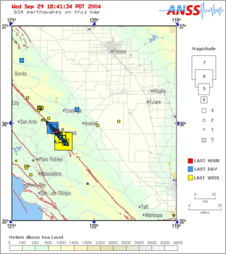
Parkfield earthquake is a name given to various large earthquakes that occurred in the vicinity of the town of Parkfield, California, United States. The San Andreas fault runs through this town, and six successive magnitude 6 earthquakes occurred on the fault at unusually regular intervals, between 12 and 32 years apart, between 1857 and 1966. The most recent significant earthquake to occur here happened on September 28, 2004.
The 1857 Fort Tejon earthquake occurred at about 8:20 a.m. on January 9 in central and Southern California. One of the largest recorded earthquakes in the United States, with an estimated moment magnitude of 7.9, it ruptured the southern part of the San Andreas Fault for a length of about 225 miles, between Parkfield and Wrightwood.

The White Wolf Fault is a fault in southern California, located along the northwestern transition of the Tejon Hills and Tehachapi Mountains with the San Joaquin Valley. It is north of the intersection of the San Andreas Fault and the Garlock Fault, and roughly parallel with the latter. It is classed as a reverse fault with a left lateral (sinistral) component.

The 2002 Denali earthquake occurred at 22:12:41 UTC November 3 with an epicenter 66 km ESE of Denali National Park, Alaska, United States. This 7.9 Mw earthquake was the largest recorded in the United States in 37 years. The shock was the strongest ever recorded in the interior of Alaska. Due to the remote location, there were no fatalities and only one injury.

The San Jacinto Fault Zone (SJFZ) is a major strike-slip fault zone that runs through San Bernardino, Riverside, San Diego, and Imperial Counties in Southern California. The SJFZ is a component of the larger San Andreas transform system and is considered to be the most seismically active fault zone in the area. Together they relieve the majority of the stress between the Pacific and North American tectonic plates.
The 1992 Cape Mendocino earthquakes occurred along the Lost Coast of Northern California on April 25 and 26. The three largest events were the M7.2 thrust mainshock that struck near the unincorporated community of Petrolia midday on April 25 and two primary strike-slip aftershocks measuring 6.5 and 6.6 that followed early the next morning. The sequence encompassed both interplate and intraplate activity that was associated with the Mendocino Triple Junction, a complex system of three major faults that converge near Cape Mendocino. The total number of aftershocks that followed the events exceeded 2,000.
The San Cayetano Fault is an east-west trending thrust fault in Ventura County, Southern California. It stretches for 45 kilometers (28 mi), north of the city of Ventura, near the Topatopa Mountains, Piru, Fillmore, Santa Paula, Sulphur Springs, and Ojai.
The 1812 San Juan Capistrano earthquake, also known simply as the Capistrano earthquake or the Wrightwood earthquake, occurred on December 8 at in Alta California. At the time, this was a colonial territory of the Spanish Empire. Damage occurred at several of the missions in the region of Pueblo de Los Ángeles, including Mission San Gabriel Arcángel and Mission San Juan Capistrano, where 40 parishioners were killed during the collapse of a church at an early morning service. Tree ring and paleoseismic evidence show that there is a strong likelihood that the earthquake originated along the Mojave segment of the San Andreas Fault near Wrightwood, but other faults have been suggested as the cause.
The 1925 Santa Barbara earthquake hit the area of Santa Barbara, California on June 29, with a moment magnitude between 6.5 and 6.8 and a maximum Mercalli Intensity of IX (Violent). It resulted in 13 deaths and destroyed the historic center of the city, with damage estimated at $8 million.
The 1838 San Andreas earthquake is believed to be a rupture along the northern part of the San Andreas Fault in June 1838. It affected approximately 100 km of the fault, from the San Francisco Peninsula to the Santa Cruz Mountains. It was a strong earthquake, with an estimated moment magnitude of 6.8 to 7.2, making it one of the largest known earthquakes in California. The region was lightly populated at the time, although structural damage was reported in San Francisco, Oakland, and Monterey. It is unknown whether there were fatalities. Based on geological sampling, the fault created approximately 1.5 meters of slip.
The 1898 Mare Island earthquake occurred in Northern California on with a moment magnitude of 5.8–6.4 and a maximum Mercalli intensity of VIII–IX (Severe–Violent). Its area of perceptibility included much of northern and central California and western Nevada. Damage amounted to $350,000 and was most pronounced on Mare Island, a peninsula in northern San Francisco Bay. While relatively strong effects there were attributed to vulnerable buildings, moderate effects elsewhere in the San Francisco Bay Area consisted of damaged or partially collapsed structures, and there were media reports of a small tsunami and mostly mild aftershocks that followed.

The 2013 Craig, Alaska earthquake struck on January 5, at 12:58 am (UTC–7) near the city of Craig and Hydaburg, on Prince of Wales Island. The Mw 7.5 earthquake came nearly three months after an Mw 7.8 quake struck Haida Gwaii on October 28, in 2012. The quake prompted a regional tsunami warning to British Columbia and Alaska, but it was later cancelled. Due to the remote location of the quake, there were no reports of casualties or damage.

An earthquake occurred off the coast of the Alaska Peninsula on July 28, 2021, at 10:15 p.m. local time. The large megathrust earthquake had a moment magnitude of 8.2 according to the United States Geological Survey (USGS). A tsunami warning was issued by the National Oceanic and Atmospheric Administration (NOAA) but later cancelled. The mainshock was followed by a number of aftershocks, including three that were of magnitude 5.9, 6.1 and 6.9 respectively.
The 2021 South Sandwich Islands earthquakes were a pair of powerful earthquakes, followed by many strong aftershocks which struck along the South Sandwich Trench in August 2021. The quakes measured 7.5 and 8.1 on the moment magnitude scale, according to the United States Geological Survey. The mainshock is tied with another event in 1929 as the largest earthquake ever recorded in the South Atlantic region, and is tied with the 2021 Kermadec Islands earthquake as the second largest earthquake of 2021.
Ruth Harris is a scientist at the United States Geological Survey known for her research on large earthquakes, especially on how they begin, end, and cause the ground to shake. In 2019, Harris was elected a fellow of the American Geophysical Union who cited her "for outstanding contributions to earthquake rupture dynamics, stress transfer, and triggering".
The 1979 Saint Elias earthquake occurred near noon local time on 28 February. It measured Mw 7.4–7.6. Though the maximum recorded Modified Mercalli intensity was VII, damage was minimal and there were no casualties due to the remoteness of the faulting. The epicenter lies near the Alaskan border between the United States and Canada.
The 1992 Joshua Tree earthquake occurred at 9:50:25 p.m. PDT on April 22 in Southern California. The magnitude 6.2 earthquake struck under the Little San Bernardino Mountains, near the town of Joshua Tree, California. Though no deaths were reported, the earthquake caused 32 injuries. A maximum Mercalli intensity of VII was observed in Joshua Tree and caused light to moderate damage. The event preceded the Landers and Big Bear earthquakes by two months but is now recognized as the beginning of a series of major earthquakes that culminated in two events on June 28, 1992.


