Related Research Articles

Wickliffe Mounds is a prehistoric, Mississippian culture archaeological site located in Ballard County, Kentucky, just outside the town of Wickliffe, about 3 miles (4.8 km) from the confluence of the Ohio and Mississippi rivers. Archaeological investigations have linked the site with others along the Ohio River in Illinois and Kentucky as part of the Angel Phase of Mississippian culture. Wickliffe Mounds is controlled by the State Parks Service, which operates a museum at the site for interpretation of the ancient community. Listed on the National Register of Historic Places, it is also a Kentucky Archeological Landmark and State Historic Site.

Hopewell Culture National Historical Park is a United States national historical park with earthworks and burial mounds from the Hopewell culture, indigenous peoples who flourished from about 200 BC to AD 500. The park is composed of six separate sites in Ross County, Ohio, including the former Mound City Group National Monument. The park includes archaeological resources of the Hopewell culture. It is administered by the United States Department of the Interior's National Park Service.

SunWatch Indian Village / Archaeological Park, previously known as the Incinerator Site, and designated by the Smithsonian trinomial 33-MY-57, is a reconstructed Fort Ancient Native American village next to the Great Miami River on West River Road in Dayton, Ohio. The dwellings and site plan of the 3-acre (1.2 ha) site are based on lengthy archeological excavations sponsored by the Dayton Society of Natural History, which owns and operates the site as an open-air museum. Because of its archaeological value, the site was listed in 1974 on the National Register of Historic Places. Since that time, as the many years of archaeological research at the site have led to important findings about the Fort Ancient culture, SunWatch Indian Village was designated in 1990 as a National Historic Landmark.

The Swan's Landing Archeological Site is an archaeological site from the Early Archaic period in Harrison County, Indiana, United States. Located along the Ohio River, it has been extensively damaged by modern activity, but it is still one of the most important sites for its time period in North America. It has been designated a historic site because of its archaeological value.
The Clough Creek and Sand Ridge Archaeological District is a historic district composed of two archaeological sites in the southwestern part of the U.S. state of Ohio. Its name is derived from those of the two sites included in the district: one that lies along Clough Creek, and one that occupies part of the Sand Ridge near the creek.

The Shawnee Lookout Archeological District is a historic district in the southwestern corner of the U.S. state of Ohio. Located southwest of Cleves in Hamilton County's Miami Township, the district is composed of forty-six archaeological sites spread out over an area of 2,000 acres (810 ha). Thirty-four of these sites are located in the 1,000-acre (400 ha) Shawnee Lookout Park, which has been called one of the most beautiful parks in southwestern Ohio.

The State Line Archeological District is a complex of archaeological sites and national historic district located west of Elizabethtown, Ohio, United States. Located on both sides of the Indiana/Ohio border, the historic district is composed of five contributing properties spread out across 8 acres (3.2 ha) of land. It is believed to have been the site of a village of the Fort Ancient culture of prehistoric Native Americans.

The Turpin Site (33Ha28) is an archaeological site in the southwestern portion of the U.S. state of Ohio. Located near Newtown in Hamilton County, the site includes the remains of a village of the Fort Ancient culture and of multiple burial mounds. Detailed explorations of the site have revealed the bodies of many individuals in and around the mounds. The archaeological value of the site has resulted in its use in the study of similar locations and in its designation as a historic site.

The Great Mound is a massive Native American mound in the southwestern part of the U.S. state of Ohio. Located in Section 19 of Madison Township in Butler County, it has a height of 43 feet (13 m) and a circumference of 511 feet (156 m). Its total volume is nearly 825,000 cubic feet (23,400 m3), making it the largest mound in Butler County and one of the largest in southwestern Ohio. Because of the mound's height and its placement on a ridgeline, an individual at the summit can see for a great distance. In the late nineteenth century, it was theorized that mounds such as the Great Mound were built as observation or watch points, and that the builders maintained the ability to light fires atop the mounds as a method of communicating across wide distances. The potential of these mounds for long-distance communication was demonstrated in 1990 by three groups of volunteers. After climbing the Great Mound, the first group established visual contact with the Hill-Kinder Mound in Franklin, from which point the observers of the second group contacted the third group atop the Miamisburg Mound near Dayton.

The Roberts Mound is a Native American mound in the southwestern part of the U.S. state of Ohio, USA. Located northwest of Auburn in Butler County, the mound sits in Section 36 of Reily Township; it is the only mound in the far southeastern part of the township.

The Clover Site (46CB40) is a Fort Ancient culture archeological site located near Lesage in Cabell County, West Virginia, United States. It is significant for its well-preserved remains of a late prehistoric/protohistoric Native American village. The site's unique assemblage has made it the type site for the Clover Phase of the Madisonville horizon of the Fort Ancient culture.

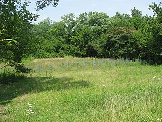
The Zimmerman Kame is a glacial kame and archaeological site in McDonald Township, Hardin County, Ohio, United States, near the community of Roundhead. A circular hill approximately 20 feet (6.1 m) in height, it was a commercial gravel pit for a time before being abandoned in the 1970s after artifacts of the ancient Glacial Kame Culture of Native Americans were found at the site. Today, the kame is tree-covered and surrounded by farm fields; there are no obvious signs of its significance.

The Ashworth Archaeological Site is a significant archaeological site in the extreme southwestern corner of the U.S. state of Indiana. Located near the confluence of the Ohio and Wabash Rivers, it lies near several similar archaeological sites. It was first examined by archaeologists in the middle of the twentieth century and found to be the site of a relatively recent Native American village, and it has been designated a historic site because of its archaeological value.
The East Fork Site is an archaeological site in the southwestern part of the U.S. state of Ohio. Located south of Batavia, it has yielded artifacts from more cultures than has any other site in Clermont County.

The Gatch Site is an archaeological site located near Milford, Ohio, United States. One of the largest archaeological sites in Clermont County, it is believed to have been a Native American village site during the Middle Woodland period.

The Cary Village Site is an archaeological site in the west-central portion of the U.S. state of Ohio. Located southeast of the village of Plain City in Madison County, the site occupies a group of grassy terraces located amid two farm fields. In this grassy area, archaeologists have discovered a wide range of artifacts, including stone tools, materials made of flint, and various types of pottery.
The Beam Farm Woodland Archaeological District is a group of archaeological sites in the southwestern part of the U.S. state of Ohio. Located at 3983 Stone Road near the village of Sabina in Clinton County, the district is composed of one Native American mound and two other archaeological sites spread out over an area of 2 acres (0.81 ha). Known as the Beam Farm Mound and the Beam Sites 9 and 12, the sites that compose the district have yielded artifacts from the Adena culture and the Hopewell tradition, both of which inhabited southwestern Ohio during the Woodland period. Because both the Adena and the Hopewell lived around the mound, and because both cultures built mounds, the identity of the people who constructed the Beam Farm Mound cannot be established; all that can be known with reasonable certainty is that it was raised during the early or middle portion of the Woodland period, or between 800 BC and AD 500.

The Bullskin Creek Site is an archaeological site in the southwestern portion of the U.S. state of Ohio. Located near Felicity in Clermont County, the site appears to have been a base camp for nomads during the Late Archaic period. The site comprises three loci: two significant areas of various debris and a large midden that underlies everything else. From these components, which cover an area of approximately 400 feet (120 m) by 600 feet (180 m), collectors and archaeologists have recovered hundreds of artifacts, including stone tools, weapons, and bone tools. Because the site is located in a farm field, it has frequently been cultivated, and the plow has brought at least five burials to the surface from a cemetery on the edge of the site. Among the types of features found at the site are ovens, trash pits, and postmolds. Bodies at the site were generally adorned with red ochre and buried in a flexed position.
Whittlesey culture is an archaeological designation for native people who lived in northeastern Ohio during the Late prehistoric and Early Contact period between A.D. 1000 to 1640. They flourished as an agrarian society by 1500—growing maize, beans, and squash—when their population began to decrease due to disease, malnutrition, and warfare. There was a period of long, cold winters that would have impacted their success cultivating food from about 1500. The Whittlesey culture people created a distinctive style of pottery and built villages that were designed to be defensive, set high on promontories with steep cliffs and then surrounded by ditches or stockades. The villages were established on the Lake Erie plain or overlooking river and streams. About 1640, Whittlesey villages were abandoned and due to the displacement of native groups during the early contact period with Europeans, it is not known where or how they relocated.
References
- 1 2 3 4 "National Register Information System". National Register of Historic Places . National Park Service. March 13, 2009.
- 1 2 Owen, Lorrie K., ed. Dictionary of Ohio Historic Places. Vol. 1. St. Clair Shores: Somerset, 1999, 139.
- ↑ Day, Gordon. "Cannel Coal Pendants". Ohio Archaeologist 8.2 (1958): 64.
| Topics | |
|---|---|
| Lists by state |
|
| Lists by insular areas | |
| Lists by associated state | |
| Other areas | |
| Related | |
