
Clermont County, popularly called Clermont, is a county in the U.S. state of Ohio. As of the 2020 census, the population was 208,601. Ordinanced in 1800 as part of the Virginia Military District, Clermont is Ohio's eighth oldest county, the furthest county west in Appalachian Ohio, and the eleventh oldest county of the former Northwest Territory. Clermont County is part of the Cincinnati, OH-KY-IN Metropolitan Statistical Area. The county is named from the French "clear hills or mountain." Its county seat is Batavia, while its largest city is Milford.

The Pulaski Skyway is a four-lane bridge-causeway in the northeastern part of the U.S. state of New Jersey, carrying an expressway designated U.S. Route 1/9 (US 1/9) for most of its length. The structure has a total length of 3.502 miles (5.636 km). Its longest bridge spans 550 feet (168 m). Traveling between Newark and Jersey City, the roadway crosses the Passaic and Hackensack rivers, Kearny Point, the peninsula between them, and the New Jersey Meadowlands.
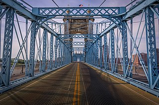
The John A. Roebling Suspension Bridge is a suspension bridge that spans the Ohio River between Cincinnati, Ohio, and Covington, Kentucky. When opened on December 1, 1866, it was the longest suspension bridge in the world at 1,057 feet (322 m) main span, which was later overtaken by John A. Roebling's most famous design of the 1883 Brooklyn Bridge at 1,595.5 feet (486.3 m). Pedestrians use the bridge to get between the hotels, bars, restaurants, and parking lots in Northern Kentucky. The bar and restaurant district at the foot of the bridge on the Kentucky side is known as Roebling Point.
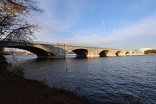
The Arlington Memorial Bridge is a Neoclassical masonry, steel, and stone arch bridge with a central bascule that crosses the Potomac River at Washington, D.C., the capital of the United States. First proposed in 1886, the bridge went unbuilt for decades thanks to political quarrels over whether the bridge should be a memorial, and to whom or what. Traffic problems associated with the dedication of the Tomb of the Unknown Soldier in November 1921 and the desire to build a bridge in time for the bicentennial of the birth of George Washington led to its construction in 1932.

The Cogan House Covered Bridge is a Burr arch truss covered bridge over Larrys Creek in Cogan House Township, Lycoming County, in the U.S. state of Pennsylvania. It was built in 1877 and is 94 feet 2 inches (28.7 m) long. The bridge was placed on the National Register of Historic Places in 1980, and had a major restoration in 1998. The Cogan House bridge is named for the township and village of Cogan House, and is also known by at least four other names: Buckhorn, Larrys Creek, Day's, and Plankenhorn.
The Sonestown Covered Bridge is a covered bridge over Muncy Creek in Davidson Township, Sullivan County, Pennsylvania built around 1850. It is 110 ft (34 m) long and was placed on the National Register of Historic Places (NRHP) in 1980. It is named for the nearby unincorporated village of Sonestown in Davidson Township, and is also known as the Davidson Covered Bridge. It was built to provide access to a grist mill which operated until the early 20th century.

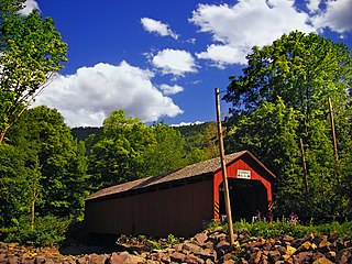
The Forksville Covered Bridge is a Burr arch truss covered bridge over Loyalsock Creek in the borough of Forksville, Sullivan County, in the U.S. state of Pennsylvania. It was built in 1850 and is 152 feet 11 inches (46.61 m) in length. The bridge was placed on the National Register of Historic Places in 1980. The Forksville bridge is named for the borough it is in, which in turn is named for its location at the confluence or "forks" of the Little Loyalsock and Loyalsock Creeks.
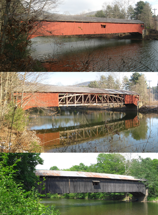
The Hillsgrove Covered Bridge is a Burr arch truss covered bridge over Loyalsock Creek in Hillsgrove Township, Sullivan County, in the U.S. state of Pennsylvania. It was built c. 1850 and is 186 feet (56.7 m) long. In 1973, it became the first covered bridge in the county to be placed on the National Register of Historic Places (NRHP). The bridge is named for the township and nearby unincorporated village of Hillsgrove, and is also known as Rinkers Covered Bridge for an adjoining farm.

The McColly Covered Bridge is a historic wooden covered bridge in western Logan County, Ohio, United States. Located in Washington Township near the community of Bloom Center, it is one of two remaining covered bridges in Logan County. It carries County Road 13 over the Great Miami River, approximately 5 miles (8.0 km) south of its source at Indian Lake.
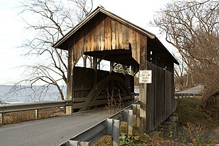
The Holmes Creek Covered Bridge, also called the Lakeshore Covered Bridge, is a one-lane wooden covered bridge that crosses Holmes Creek in Charlotte, Vermont on Lake Road, adjacent to Charlotte Beach. It was listed on the National Register of Historic Places in 1974.

The Pulp Mill Covered Bridge, also called the Paper Mill Covered Bridge, is a wooden covered bridge that crosses Otter Creek between Middlebury and Weybridge, Vermont on Seymour Street. It was listed on the National Register of Historic Places in 1974.
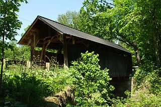
The Seguin Covered Bridge, also called the Upper Covered Bridge and the Sequin Covered Bridge, is a wooden covered bridge that crosses Lewis Creek in Charlotte, Vermont on Roscoe Road. It was built about 1850, and is a distinctive variant of a Burr arch design. It was listed on the National Register of Historic Places in 1974.
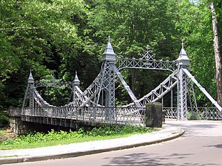
The Mill Creek Park Suspension Bridge is a bridge in Youngstown, Ohio, United States. The 1895 bridge carries Valley Drive across Mill Creek to connect the east and west sides of Mill Creek Park. Following the wishes of Volney Rogers to create fanciful park entrances, Charles Fowler of the Youngstown Bridge Co. designed the structure. The Suspension Bridge is the oldest of six bridges in Mill Creek Park. It measures 86 feet long and 32 feet wide and was listed on the National Register of Historic Places in 1976. It has been called the Silver Bridge, the Cinderella Bridge, the Castle Bridge, and the Walt Disney Bridge. In the summer and fall of 2007, the Suspension Bridge went through a major rehabilitation project to repair the historic structure, restore its visual prominence and improve its structural integrity. The project was coordinated through consultation with the Mahoning Valley Historical Society, Youngstown State University, the Ohio Historic Preservation Office and additional agencies. A Federal Highway Administration Enhancement Grant, secured through the Eastgate Regional Council of Governments, covered 80% of the total project cost. The bridge has been restored to its original splendor, reflecting its history, legacy, aesthetic appeal, cultural prominence and regional character.

The Second Street Bridge is a one-lane, single-span truss bridge in Allegan, in the U.S. state of Michigan, that carries Second Street over the Kalamazoo River. It is a Michigan State Historic Site, a National Historic Civil Engineering Landmark, and is listed on the National Register of Historic Places. Built in 1886, the bridge replaced an earlier wooden structure. In the early 1980s, the bridge underwent significant renovation.

The Geeting Covered Bridge, also known as Geeting Bridge, is a historic covered bridge crossing Price's Creek on Price Road west of Lewisburg, Ohio, United States. It was built in 1894 by Everett S. Sherman, one of at least 20 covered bridges built by Sherman in Preble County, Ohio. The abutments were built by the Koppee Brothers. It was listed on the National Register of Historic Places in 1975.
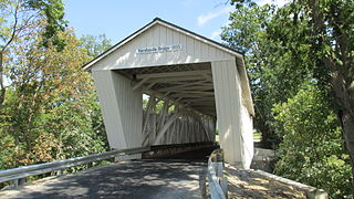
The Harshaville Covered Bridge is a historic covered bridge spanning the Cherry Fork Creek at Harshaville, Adams County, Ohio. Built in 1855, it is a Burr truss bridge with a 110-foot span. It has sheet metal siding, a metal roof and stone abutments. It was listed on the National Register of Historic Places in 1976.

On May 23, 2013, at approximately 7:00 pm PDT, a span of the bridge carrying Interstate 5 over the Skagit River in the U.S. state of Washington collapsed. Three people in two different vehicles fell into the river below and were rescued by boat, escaping serious injury. The cause of the catastrophic failure was determined to be an oversize load striking several of the bridge's overhead support beams, leading to an immediate collapse of the northernmost span.

The Lincoln Covered Bridge is a historic covered bridge, just south of U.S. Route 4 in West Woodstock, Vermont. Built in 1877, it is one of the only known examples of a wooden Pratt truss bridge in the United States. It was listed on the National Register of Historic Places in 1973.

The Kidwell Covered Bridge, in Dover Township, Athens County, Ohio between the nearby hamlets of Truetown and Redtown, was built in 1880. It spans Sunday Creek. It was listed on the National Register of Historic Places in 1977.
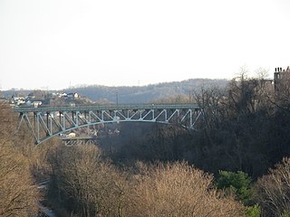
The Charles Anderson Memorial Bridge is a steel deck truss bridge located in Pittsburgh, Pennsylvania, United States. The bridge carries the four-lane roadway of Boulevard of the Allies across a ravine known as Junction Hollow, connecting the neighborhoods of Central Oakland and South Oakland with Schenley Park. The bridge also spans the Junction Hollow Trail and P&W Subdivision railroad tracks which run along the bottom of the valley.


