Claryville, Kentucky

Last updated

Claryville, Kentucky
Campbell County Kentucky incorporated and unincorporated areas Claryville highlighted.svg
Location in Campbell County and the state of Kentucky.
Coordinates: 38°54′50″N84°24′34″W / 38.91389°N 84.40944°W / 38.91389; -84.40944
Country United States
State Kentucky
County Campbell
Area
[1]
  Total7.20 sq mi (18.65 km2)
  Land7.20 sq mi (18.65 km2)
  Water0.00 sq mi (0.00 km2)
Elevation
[2]
735 ft (224 m)
Population
 (2020)
  Total2,992
  Density415.50/sq mi (160.43/km2)
Time zone UTC-5 (Eastern (EST))
  Summer (DST) UTC-4 (EDT)
ZIP code
41001
Area code 859
FIPS code 21-15166
GNIS feature ID2402781 [2]

Claryville is an unincorporated community and census-designated place (CDP) in Campbell County, Kentucky, United States. The population was 2,992 at the 2020 census.

Contents

History

Claryville was named for the Clary family of pioneer settlers. [3]

Geography

Claryville is located in southwestern Campbell County. Its western border, Pond Creek Road, runs along the Licking River, which forms the Kenton County line. U.S. Route 27 (Alexandria Pike) is a four-lane highway that passes through the eastern part of Claryville, leading north through Alexandria 16 miles (26 km) to downtown Cincinnati, Ohio, and south 19 miles (31 km) to Falmouth.

According to the United States Census Bureau, the CDP has a total area of 6.9 square miles (18.0 km2), all land. [4]

Demographics

Historical population
CensusPop.Note
2020 2,992
U.S. Decennial Census [5]

As of the census [6] of 2000, there were 2,588 people, 942 households, and 725 families residing in the CDP. The population density was 371.1 inhabitants per square mile (143.3/km2). There were 993 housing units at an average density of 142.4 per square mile (55.0/km2). The racial makeup of the CDP was 99.11% White, 0.27% African American, 0.12% Native American, 0.12% Asian, 0.08% from other races, and 0.31% from two or more races. Hispanic or Latino of any race were 0.46% of the population.

There were 942 households, out of which 38.2% had children under the age of 18 living with them, 63.4% were married couples living together, 9.4% had a female householder with no husband present, and 23.0% were non-families. 18.8% of all households were made up of individuals, and 4.7% had someone living alone who was 65 years of age or older. The average household size was 2.75 and the average family size was 3.14.

In the CDP, the population was spread out, with 26.2% under the age of 18, 11.1% from 18 to 24, 30.4% from 25 to 44, 23.6% from 45 to 64, and 8.7% who were 65 years of age or older. The median age was 35 years. For every 100 females, there were 100.2 males. For every 100 females age 18 and over, there were 97.0 males.

The median income for a household in the CDP was $49,231, and the median income for a family was $52,083. Males had a median income of $39,150 versus $27,500 for females. The per capita income for the CDP was $21,367. About 3.7% of families and 4.6% of the population were below the poverty line, including 4.8% of those under age 18 and none of those age 65 or over.

Education

Residents are within the Campbell County School District. [7] Residents are zoned to Campbell County High School in Claryville, Kentucky

Related Research Articles

<span class="mw-page-title-main">Okahumpka, Florida</span> Census-designated place in Florida

Okahumpka is an unincorporated community and census-designated place (CDP) in Lake County, Florida, United States. The population was 267 at the 2010 census. It is part of the Orlando–Kissimmee Metropolitan Statistical Area.

<span class="mw-page-title-main">Eden Roc, Hawaii</span> Census-designated place in Hawaii, United States

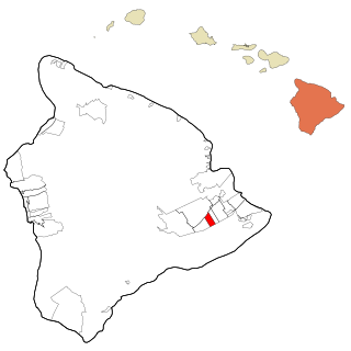
Eden Roc is a census-designated place (CDP) in Hawaiʻi County, Hawaiʻi, United States, located in the District of Puna. The population was 942 at the 2010 census, up from 451 at the 2000 census.

<span class="mw-page-title-main">Oakbrook, Kentucky</span> Census-designated place in Kentucky, United States

Oakbrook is a census-designated place (CDP) in Boone County, Kentucky, United States. The population was 9,268 at the 2020 census.

<span class="mw-page-title-main">Brooks, Kentucky</span> Census-designated place in Kentucky, United States

Brooks is a census-designated place (CDP) in Bullitt County, Kentucky, United States. The population was 2,401 at the 2010 census. Brooks was struck by a tornado in 1996.

<span class="mw-page-title-main">Alexandria, Kentucky</span> City in Kentucky, United States

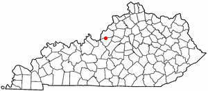
Alexandria is a home rule-class city in Campbell County, Kentucky, in the United States. Along with Newport, it is one of the dual seats of the county. The population was 10,341 at the 2020 census.

<span class="mw-page-title-main">Cold Spring, Kentucky</span> City in Kentucky, United States

Cold Spring is a home rule-class city in Campbell County, Kentucky, in the United States. The population was 6,216 at the 2020 census. It is part of the Cincinnati-Northern Kentucky metropolitan area.

<span class="mw-page-title-main">Crestview, Kentucky</span> City in Kentucky, United States

Crestview is a home rule-class city in Campbell County, Kentucky, in the United States. The population was 452 at the 2020 census.

<span class="mw-page-title-main">Mentor, Kentucky</span> City in Kentucky, United States

Mentor is a home rule-class city in Campbell County, Kentucky, United States. The population was 218 as of the 2020 census.

Fort Campbell North is a census-designated place (CDP) in Christian County, Kentucky, United States. It contains most of the housing for the Fort Campbell Army base within the Kentucky portion of the base. The population was 13,685 at the 2010 census, down from 14,338 in 2000.

<span class="mw-page-title-main">Ledbetter, Kentucky</span> CDP in Kentucky, United States

Ledbetter is a census-designated place (CDP) in Livingston County, Kentucky, United States. The population was 1,683 at the 2010 census, down slightly from 1,700 in 2000, thus making it the largest and most populous community in Livingston County. It is part of the Paducah, KY-IL Micropolitan Statistical Area, laying directly across the Tennessee River from Paducah.

<span class="mw-page-title-main">Pine Knot, Kentucky</span> Census-designated place in Kentucky, United States

Pine Knot is an unincorporated community and census-designated place (CDP) in McCreary County, Kentucky, United States. The population was 1,380 at the 2020 census, down from 1,621 in 2010.

<span class="mw-page-title-main">Whitley City, Kentucky</span> Census-designated place in Kentucky, United States

Whitley City is an unincorporated community and census-designated place (CDP) in McCreary County, Kentucky, United States. The population was 968 at the 2020 census, down from 1,170 in 2010. It is the county seat of McCreary County. Whitley City is one of two unincorporated county seats in Kentucky.

<span class="mw-page-title-main">Buckner, Kentucky</span> CDP in Kentucky, United States

Buckner is a census-designated place (CDP) in Oldham County, Kentucky, United States. The population was 4,000 at the 2000 census.

<span class="mw-page-title-main">Greentree, New Jersey</span> Populated place in Camden County, New Jersey, US

Greentree is an unincorporated community and census-designated place (CDP) located within Cherry Hill Township, in Camden County, in the U.S. state of New Jersey. As of the 2010 United States Census, the CDP's population was 11,367.

<span class="mw-page-title-main">Chenoweth, Oregon</span> Unincorporated community in the state of Oregon, United States

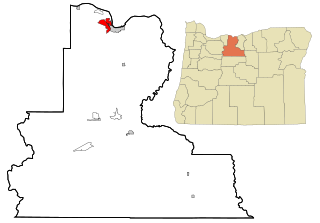
Chenoweth is an unincorporated community in Wasco County, Oregon, United States. Locally the alternative spelling of Chenowith is used, such as for the 'Chenowith Elementary School'. For statistical purposes, the United States Census Bureau has defined Chenoweth as a census-designated place (CDP). The census definition of the area may not precisely correspond to local understanding of the area with the same name. The population of the CDP was 3,412 at the 2000 census.

<span class="mw-page-title-main">Rustburg, Virginia</span> Census-designated place in Virginia, United States

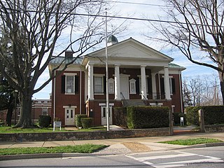
Rustburg is a census-designated place (CDP) in and the county seat of Campbell County, Virginia, United States. The population was 1,431 at the 2010 census. It is part of the Lynchburg Metropolitan Statistical Area.

<span class="mw-page-title-main">Groveton, Virginia</span> Census-designated place in Virginia, United States

Groveton is a census-designated place (CDP) in Fairfax County, Virginia, United States. The population was 14,598 at the 2010 census, down from 21,296 in 2000 due to a reduction in area. Located south of the city of Alexandria, it encompasses numerous neighborhoods including Groveton, Bucknell Manor, Stoneybrooke, and portions of Hollin Hills. Huntley Meadows Park, Fairfax County's largest park, is located in the southwest part of the CDP.

<span class="mw-page-title-main">Huntington, Virginia</span> Census-designated place in Virginia, United States

Huntington is a census-designated place (CDP) in Fairfax County, Virginia, United States. The population was 11,267 at the 2010 census. It is located next to the southern border of the city of Alexandria and is part of the Washington metropolitan area. Its main component is the namesake Huntington subdivision, a late-1940s neighborhood of mainly duplex homes.

<span class="mw-page-title-main">Lincolnia, Virginia</span> Census-designated place in Virginia, United States

Lincolnia is a census-designated place (CDP) in Fairfax County, Virginia, United States. The population was 22,828 at the 2010 census, an increase of over 44% from 2000.

<span class="mw-page-title-main">Keokee, Virginia</span> Census-designated place in Virginia, United States

Keokee is an unincorporated community and census-designated place (CDP) in Lee County, Virginia, United States. The population was 416 at the 2010 census.

References

  1. "2020 U.S. Gazetteer Files". United States Census Bureau. Retrieved March 18, 2022.
  2. 1 2 U.S. Geological Survey Geographic Names Information System: Claryville, Kentucky
  3. "Chapter C of the Encyclopedia of Northern Kentucky". The University Press of Kentucky. p. 197. Retrieved June 25, 2014.
  4. "Geographic Identifiers: 2010 Demographic Profile Data (G001): Claryville CDP, Kentucky". U.S. Census Bureau, American Factfinder. Archived from the original on February 12, 2020. Retrieved August 6, 2014.
  5. "Census of Population and Housing". Census.gov. Retrieved June 4, 2016.
  6. "U.S. Census website". United States Census Bureau . Retrieved January 31, 2008.
  7. "SCHOOL DISTRICT REFERENCE MAP (2010 CENSUS): Campbell County, KY" (). U.S. Census Bureau. Retrieved on May 8, 2014.