Wilder, Kentucky

Last updated

Wilder, Kentucky
Campbell County Kentucky Incorporated and Unincorporated areas Wilder Highlighted 2183172.svg
Location of Wilder in Campbell County, Kentucky.
Coordinates: 39°02′24″N84°28′54″W / 39.04000°N 84.48167°W / 39.04000; -84.48167
Country United States
State Kentucky
County Campbell
Area
[1]
  Total3.75 sq mi (9.72 km2)
  Land3.63 sq mi (9.39 km2)
  Water0.13 sq mi (0.33 km2)
Elevation
[2]
646 ft (197 m)
Population
 (2020)
  Total3,176
  Estimate 
(2022) [3]
3,123
  Density876.14/sq mi (338.26/km2)
Time zone UTC-5 (Eastern (EST))
  Summer (DST) UTC-4 (EDT)
ZIP codes
41071, 41076
Area code 859
FIPS code 21-83172
GNIS feature ID2405743 [2]
Website wilderky.gov

Wilder is a home rule-class city in Campbell County, Kentucky, United States. The population was 3,176 at the 2020 census. It is part of the Cincinnati-Northern Kentucky metropolitan area.

Contents

Geography

According to the United States Census Bureau, the city has a total area of 3.8 square miles (9.8 km2), of which 3.7 square miles (9.6 km2) is land and 0.1 square miles (0.26 km2) (2.89%) is water.

History

Wilder was once known as Leitch's Station. It was the first settlement in Campbell County. The name Wilder dates back to a railroad station built in the mid-19th century for the Louisville, Cincinnati and Lexington Railway named Wilder station. St. John the Baptist Roman Catholic Church was built in 1858 by German immigrants. "Wilder Station" is now located on property owned by Newport Steel. It is the home of supposed ghostly hauntings at the country music nightclub and honky tonk, Bobby Mackey's Music World, which has been called "the most haunted nightclub in America".

Demographics

Historical population
CensusPop.Note
1940 287
1950 204−28.9%
1960 23917.2%
1970 823244.4%
1980 633−23.1%
1990 6919.2%
2000 2,624279.7%
2010 3,03515.7%
2020 3,1764.6%
2022 (est.)3,123 [4] −1.7%
U.S. Decennial Census [5]

As of the census [6] of 2000, there were 2,624 people, 1,162 households, and 743 families residing in the city. The population density was 707.8 inhabitants per square mile (273.3/km2). There were 1,200 housing units at an average density of 323.7 per square mile (125.0/km2). The racial makeup of the city was 94.51% White, 2.29% African American, 0.11% Native American, 1.56% Asian, 0.53% from other races, and 0.99% from two or more races. Hispanic or Latino of any race were 0.95% of the population.

There were 1,162 households, out of which 28.1% had children under the age of 18 living with them, 49.5% were married couples living together, 12.4% had a female householder with no husband present, and 36.0% were non-families. 31.2% of all households were made up of individuals, and 7.1% had someone living alone who was 65 years of age or older. The average household size was 2.26 and the average family size was 2.85.

In the city, the population was spread out, with 23.0% under the age of 18, 7.2% from 18 to 24, 35.2% from 25 to 44, 23.3% from 45 to 64, and 11.3% who were 65 years of age or older. The median age was 36 years. For every 100 females, there were 82.3 males. For every 100 females age 18 and over, there were 80.5 males.

The median income for a household in the city was $49,567, and the median income for a family was $65,089. Males had a median income of $42,380 versus $35,230 for females. The per capita income for the city was $27,693. About 5.9% of families and 7.0% of the population were below the poverty line, including 12.7% of those under age 18 and 2.0% of those age 65 or over.

Related Research Articles

<span class="mw-page-title-main">Grundy Center, Iowa</span> City in Iowa, United States

Grundy Center is a city in Grundy County, Iowa. The population was 2,796 at the time of the 2020 census, a 7.7% increase from 2,596 at the 2000 census. Grundy Center is also the county seat of Grundy County. Grundy Center is part of the Waterloo–Cedar Falls Metropolitan Statistical Area.

<span class="mw-page-title-main">Lawrenceburg, Kentucky</span> City in Kentucky, United States

Lawrenceburg is a home rule-class city in Anderson County, Kentucky, United States. The population was 11,728 at the 2020 census. It is the seat of its county. Lawrenceburg is part of the Frankfort, Kentucky, micropolitan statistical area.

<span class="mw-page-title-main">Cold Spring, Kentucky</span> City in Kentucky, United States

Cold Spring is a home rule-class city in Campbell County, Kentucky, in the United States. The population was 6,216 at the 2020 census. It is part of the Cincinnati-Northern Kentucky metropolitan area.

<span class="mw-page-title-main">Sanders, Kentucky</span> City in Kentucky, United States

Sanders is a home rule-class city in Carroll County, Kentucky, in the United States. The population was 238 as of the 2010 census.

<span class="mw-page-title-main">Wingo, Kentucky</span> City in Kentucky, United States

Wingo is a home rule-class city in Graves County, Kentucky, United States. The population was 632 at the 2010 census.

<span class="mw-page-title-main">Cambridge, Kentucky</span> City in Kentucky, United States

Cambridge is a home rule-class city in Jefferson County, Kentucky, United States. The population was 175 at the 2010 census.

<span class="mw-page-title-main">Goose Creek, Kentucky</span> City in Kentucky, United States

Goose Creek is a home rule-class city in Jefferson County, Kentucky, United States. The population was 294 at the 2010 census.

<span class="mw-page-title-main">Houston Acres, Kentucky</span> City in Kentucky, United States

Houston Acres is a home rule-class city in Jefferson County, Kentucky, United States. The population was 507 at the 2010 census.

<span class="mw-page-title-main">Meadowview Estates, Kentucky</span> City in Kentucky, United States

Meadowview Estates is a home rule-class city in Jefferson County, Kentucky, United States. The population was 178 at the 2020 census,.

<span class="mw-page-title-main">Old Brownsboro Place, Kentucky</span> City in Jefferson County, Kentucky, United States

Old Brownsboro Place is a home rule-class city in Jefferson County, Kentucky, United States, and a part of the united Metro government. The population was 353 at the 2010 census.

<span class="mw-page-title-main">Poplar Hills, Kentucky</span> City in Kentucky, United States

Poplar Hills is a home rule-class city in Jefferson County, Kentucky, United States. It is a part of the Louisville Metro government, but operates as a city under the Mayor to Commissioner form of government. Per the 2020 census, the population was 380, but the city administration has made several annexation ordinances that have passed and awaits updated information. The current city population is estimated to be 2380. It currently has the highest population density for any city in Kentucky.

<span class="mw-page-title-main">Thornhill, Kentucky</span> City in Kentucky, United States

Thornhill is a home rule-class city in Jefferson County, Kentucky, United States. The population was 178 at the 2010 census.

<span class="mw-page-title-main">Woodland Hills, Kentucky</span> City in Kentucky, United States

Woodland Hills is a home rule-class city in Jefferson County, Kentucky, United States. The population was 696 at the 2010 census.

<span class="mw-page-title-main">Fort Mitchell, Kentucky</span> City in Kentucky, United States

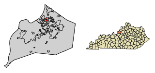
Fort Mitchell is a home rule-class city in Kenton County, Kentucky, United States. The population was 8,702 at the 2020 census. It is part of the Cincinnati metropolitan area.

<span class="mw-page-title-main">Island, Kentucky</span> City in Kentucky, United States

Island is a home rule-class city in McLean County, Kentucky, in the United States. The population was 429 at the 2020 census. It is included in the Owensboro metropolitan area.

<span class="mw-page-title-main">Pewee Valley, Kentucky</span> City in Kentucky, United States

Pewee Valley is a home rule-class city in Oldham County, Kentucky, United States. The population was 1,456 at the 2010 census.

<span class="mw-page-title-main">Booneville, Kentucky</span> City in Kentucky, United States

Booneville is a home rule-class city in Owsley County, Kentucky, in the United States. The population was 81 at the 2010 census. It is the county seat of Owsley County. It is located at the junction of Kentucky Route 11 and Kentucky Route 30 on the South Fork of the Kentucky River.

Chatham Township is a township in Wright County, Minnesota, United States. The population was 1,162 at the 2000 census.

<span class="mw-page-title-main">Wiconisco Township, Pennsylvania</span> Township in Pennsylvania, United States

Wiconisco Township is a township in Dauphin County, Pennsylvania, United States. The population was 1,162 in the 2020 census. Wiconisco Township took its name from Wiconisco Creek, a west-flowing tributary of the Susquehanna River.

<span class="mw-page-title-main">Gruver, Texas</span> City in Texas, United States

Gruver is a city in Hansford County, Texas, United States. The population was 1,162 at the 2010 census. Farwell, in the center of Hansford County, approximately three miles east of what became Gruver, was established in 1880 by the Canott family of Illinois, and was the first town in the county. Gruver was established shortly after, and Farwell rapidly fell into oblivion after 1889, when it lost a county seat election to Hansford.

References

  1. "2020 U.S. Gazetteer Files". United States Census Bureau. Retrieved March 18, 2022.
  2. 1 2 U.S. Geological Survey Geographic Names Information System: Wilder, Kentucky
  3. "Annual Estimates of the Resident Population for Incorporated Places in Kentucky: April 1, 2020 to July 1, 2022". United States Census Bureau. Retrieved May 26, 2023.
  4. "Annual Estimates of the Resident Population for Incorporated Places in Kentucky: April 1, 2020 to July 1, 2022". United States Census Bureau. Retrieved May 26, 2023.
  5. "Census of Population and Housing". Census.gov. Retrieved June 4, 2015.
  6. "U.S. Census website". United States Census Bureau . Retrieved January 31, 2008.