Clear Creek (Atlanta)

Last updated
Detail from bird's-eye view of northeast Atlanta showing tributaries that form the headwaters of Clear Creek. Detail from Saunders and Kline's "Bird's-eye View of Atlanta, Ga.," 1892.jpg
Detail from bird's-eye view of northeast Atlanta showing tributaries that form the headwaters of Clear Creek.
Streetcar along North Ave. crossing western branch of Clear Creek, near today's intersection of North and Penn at the boundary of what are now Midtown and the Old Fourth Ward. (Atlanta History Center) Bridge over clear creek at ponce and penn.jpg
Streetcar along North Ave. crossing western branch of Clear Creek, near today's intersection of North and Penn at the boundary of what are now Midtown and the Old Fourth Ward. (Atlanta History Center)

Clear Creek is a stream in northeast Atlanta that is a tributary to Peachtree Creek and part of the Chattahoochee River watershed. It has two main branches, one originating east of the high ground along which Boulevard runs and another to the west originating on the northeast side of downtown Atlanta. The easterly branch of Clear Creek begins in several springs and branches in what are now Inman Park and the Old Fourth Ward. Flowing north, the creek was joined by other branches and springs, including Angier Springs near the end of Belgrade Avenue and the so-called Ponce de Leon Springs, which were “discovered” during railroad construction in the 1860s and gave rise to the eponymous park and avenue.

Contents

The western branch of Clear Creek began in the northeast quadrant of downtown between Decatur and Peachtree Streets and flowed through the lowlands east of Piedmont Avenue where the Atlanta Civic Center was built in the mid-1960s. In the fall of 1864 the Union Army camped along the creek, and for several decades that prong of Clear Creek was known as Shermantown Branch. Flowing in a northeasterly meander through the eastern side of the Midtown neighborhood, it joined the eastern prong of the creek in the vicinity of the present Midtown High School stadium. [1]

From there the creek flowed in a northerly direction and is joined by several smaller tributaries, including one which originated in at least two springs, one in the vicinity of the Federal Reserve and another northeast of the intersection of Eighth and Juniper Streets. Their water combined to form a branch that was large enough to be dammed in 1894 to create Piedmont Park's Clara Meer. Today there are six springs in the restored wetlands below the dam. A somewhat larger branch drains Orme Park and a large part of the northwest side of Virginia-Highland as well as the southwest side of Morningside. Sometimes known as Stillhouse Branch in the nineteenth century, it joins Clear Creek a few hundred feet west of the dead end of Dutch Valley Road. A smaller branch drains most of Ansley Park, emptying into Clear Creek in the Ansley Golf Club's course east of Montgomery Ferry Road, and yet another branch out of Sherwood Forest flows into Clear Creek just east of the Interstate 85 bridge.

In the mid-nineteenth century, a grist mill was located just downstream from where the Beltline crosses the creek at the northern end of Piedmont Park. As Jones Mill, it was a landmark in maps from the Civil War, but it is often known as Walkers Mill, for a later owner.

For decades in the late nineteenth and early twentieth centuries, the creek was used as a sewer and polluted by industrial waste. The western branch was completely buried by the 1930s and much of the eastern branch by 1950. North of Tenth Street, the creek was turned into a large concrete channel through Piedmont Park and through the Ansley golf course.

Recent efforts to improve water quality, habitat, access and opportunities for nature appreciation

Clear Creek Basin at Historic Fourth Ward Park (2011)

Historic Fourth Ward Park comprises 17 acres of headwaters greenspace [2] and is built on the site of the old Ponce de Leon amusement park, just south of Ponce City Market and just west of the BeltLine trail. Intended to provide stormwater management for an area undergoing intensive redevelopment, it was one of the first completed urban park elements of the Atlanta BeltLine project.

Construction includes a two-acre detention pond providing relief to the City of Atlanta's combined sewer system, a 24” tap into the existing 9’ x 9’ Clear Creek trunk sewer, the installation of nearly 1,000 LF 6’ x 3’ box culvert, re-routing and reconstructing city streets, elevated walkways, extensive walls, ramps, various hardscapes, decorative railings, site lighting, wetlands plantings and landscaping. [3] The pond generates a minimum of 425 gallons a minute from the submerged Clear Creek water table available for maintaining the park's lawns and playing fields. Additional water features include a ten-foot waterfall to aerate and recycle the pond water and a stone water cascade that runs alongside one of the park's walkways.

Stream and wetland rehabilitation at Piedmont Park (2011)

Recent parkland expansion and multimillion-dollar green infrastructure developments (2011, [4] 2013 [5] ) managed through the Piedmont Park Conservancy are designed to improve Clear Creek's water quality and enhance biodiversity. Educational signage along the waterway offers information about the importance of healthy watershed systems.

Clear Creek CSO Treatment Facility at 1320 Monroe Drive (1996)

Comprising approximately 3,086 acres and having a maximum overflow capacity of approximately 5,060 million gallons per day (mgd), the Clear Creek CSO Facility serves the largest combined sewershed of the city's seven CSO facilities, and includes the Downtown Business District and Midtown Atlanta. Dry weather flow (less than 40 mgd is routed to the Peachtree interceptor), which then takes the flow to the R.M. Clayton WRC for treatment. Wet weather flow is routed to the Clear Creek CSO facility for treatment before being discharged to an open channel that leads to Clear Creek. Existing treatment consists of coarse screening, fine screening, and disinfection by sodium hypochlorite.

Clear Creek Nature Preserve & City of Atlanta Greenway Acquisition Project (1998 - 2007)

The City of Atlanta Greenway Acquisition Project was a $25 million program to acquire and protect properties adjacent to selected rivers and creeks within the Metro Atlanta area. Once acquired, these greenway properties are to be forever maintained in a natural, undisturbed state. Clear Creek Nature Preserve of Brookwood Hills Community Club comprises 70 acres of privately held riparian bottomland protected by conservation easement through the Greenway Acquisition Project. Conservation of greenway properties protects water quality in rivers and streams and also protects animal habitats, plant habitats, and wetlands. Land adjacent to the waterways is to be protected from erosion, flood damage, and clear-cutting.

New urbanism style planning and redevelopment within the Clear Creek watershed and BeltLine corridor

Greater Piedmont Heights Master Framework Plan (2012)

Objectives:

1. Unify the many plans by others in and around Piedmont Heights into a single implementable Master Framework Plan leveraging community assets, respecting the interests of all persons and following the Hannover Principles.*

2. Modify Buford Highway, Monroe Drive and Piedmont Road for more appropriate interface with abutting neighborhoods and to divert through traffic away from residential areas.

3. Transform the open space under I-85 and along the Peachtree Creek waterway into cultural and environmental assets.

4. Alter internal streets and intersections for safety and walkability, to minimize vehicle/pedestrian conflicts and to encourage appropriate new development.

5. Create a plan for additional green space and a pedestrian network connecting the neighborhood to the BeltLine, nearby trails, parks, creeks and open spaces.

6. Integrate existing and proposed public transit systems ensuring minimum disruption and optimum access.

Ponce City Market (2014)

Located where the BeltLine crosses Ponce de Leon Avenue in the Old Fourth Ward; a mixed-use development of the historic Sears, Roebuck & Co. building. The 2,100,000-square-foot structure is one of the largest by volume in the Southeast United States. The building's lot covers 16 acres.

Armour Yards and Sweetwater Design District (2015)

The SweetWater Design District (2010) located around Armour Circle, Ottley Drive and Plasters Avenue NE, [6] was established to foster a welcoming atmosphere for visitors and to create a stronger community among the businesses and organizations .

Armour Yards (2015), near Sweetwater Brewery and a future BeltLine connection, is a 6.5 acre, mixed-use, west coast style, loft office campus by Third & Urban, a real estate development and investment firm. [7]

Related Research Articles

Peachtree Street Main street of Atlanta, Georgia, USA

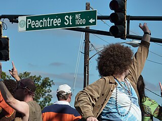
Peachtree Street is one of several major streets running through the city of Atlanta. Beginning at Five Points in downtown Atlanta, it runs North through Midtown; a few blocks after entering into Buckhead, the name changes to Peachtree Road at Deering Road. Much of the city's historic and noteworthy architecture is located along the street, and it is often used for annual parades,, as well as one-time parades celebrating events such as the 100th anniversary of Coca-Cola in 1986 and the Atlanta Braves' 1995 World Series victory.

Midtown Atlanta Neighborhoods of Atlanta in Fulton County, Georgia, United States

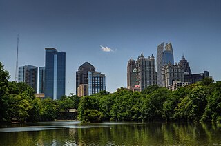
Midtown Atlanta, or Midtown, is a high-density commercial and residential neighborhood of Atlanta, Georgia. The exact geographical extent of the area is ill-defined due to differing definitions used by the city, residents, and local business groups. However, the commercial core of the area is anchored by a series of high-rise office buildings, condominiums, hotels, and high-end retail along Peachtree Street between North Avenue and 17th Street. Midtown, situated between Downtown to the south and Buckhead to the north, is the second-largest business district in Metro Atlanta. In 2011, Midtown had a resident population of 41,681 and a business population of 81,418.

The Atlanta BeltLine is a 22 miles (35 km) open and planned loop of multi-use trail and light rail transit system on a former railway corridor around the core of Atlanta, Georgia. The Atlanta BeltLine is designed to reconnect neighborhoods and communities historically divided and marginalized by infrastructure, improve transportation, add green space, promote redevelopment, create and preserve affordable housing, and showcase arts and culture. The project is in varying stages of development, with several mainline and spur trails complete and others in an unpaved, but hikeable, state. Since the passage of the More MARTA sales tax in 2016, construction of the light rail streetcar system is overseen by MARTA in close partnership with Atlanta BeltLine, Inc.

Virginia–Highland Neighborhoods of Atlanta in Fulton County, Georgia, United States

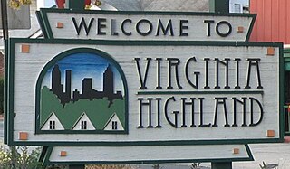
Virginia–Highland is an affluent neighborhood of Atlanta, Georgia, founded in the early 20th century as a streetcar suburb. It is named after the intersection of Virginia Avenue and North Highland Avenue, the heart of its trendy retail district at the center of the neighborhood. The neighborhood is famous for its bungalows and other historic houses from the 1910s to the 1930s. It has become a destination for people across Atlanta with its eclectic mix of restaurants, bars, and shops as well as for the Summerfest festival, annual Tour of Homes and other events.

From its incorporation in 1847, the municipal boundaries of Atlanta, Georgia, United States, were extended repeatedly from a small area around its railroad station to today's city covering 131.7 square miles (341 km2).

Ansley Park United States historic place

Ansley Park is an intown residential district in Atlanta, Georgia, located just east of Midtown and west of Piedmont Park. When developed in 1905-1908, it was the first Atlanta suburban neighborhood designed for automobiles, featuring wide, winding roads rather than the grid pattern typical of older streetcar suburbs. Streets were planned like parkways with extensive landscaping, while Winn Park and McClatchey Park are themselves long and narrow, extending deep into the neighborhood.

Arts Center station (MARTA) MARTA rail station

Arts Center station is a train station in Atlanta, Georgia, serving the Red and Gold lines of the Metropolitan Atlanta Rapid Transit Authority (MARTA) rail system. It is the northernmost of three MARTA stations that serve Midtown Atlanta, the others being Midtown and North Avenue.

Old Fourth Ward Neighborhoods of Atlanta in Fulton County, Georgia, United States

The Old Fourth Ward, often abbreviated O4W, is an intown neighborhood on the eastside of Atlanta, Georgia, United States. The neighborhood is best known as the location of the Martin Luther King Jr. historic site.

Ponce de Leon Avenue Road in Georgia, USA

Ponce de Leon Avenue, often simply called Ponce, provides a link between Atlanta, Decatur, Clarkston, and Stone Mountain, Georgia. It was named for Ponce de Leon Springs, in turn from explorer Juan Ponce de León, but is not pronounced as in Spanish. Several grand and historic buildings are located on the avenue.

North Avenue (Atlanta)

North Avenue is a major avenue in Atlanta, Georgia that divides Downtown Atlanta from Midtown Atlanta. North Avenue stretches continuously in Atlanta from Candler Park in the east, across Interstate 75 & Interstate 85, along the southern boundary of the Georgia Institute of Technology, to Joseph E. Lowery Boulevard just southwest of Georgia Tech, where it ends. North Avenue passes through the neighborhoods of Poncey-Highland, Old Fourth Ward, and Midtown Atlanta.

Capitol View, Atlanta

Capitol View is an in-town Atlanta neighborhood 2.5 miles from downtown Atlanta, Georgia that was named for its excellent view of the Georgia State Capitol building. Its boundaries include Metropolitan Parkway to the east, Lee Street to the west, and the Beltline to the north. On the south, the border follows Arden Street, Deckner Avenue, and Perkerson Park. Its central location is only minutes away from Atlanta Downtown Atlanta, Midtown Atlanta, Buckhead, College Park, East Point, Hartsfield-Jackson Atlanta International Airport, and major highways and interstates such as the Downtown Connector/I-75/I-85, I-20, and Metropolitan Parkway.

Streetcars in Atlanta Aspect of the history of Atlanta, Georgia, USA

Streetcars originally operated in Atlanta downtown and into the surrounding areas from 1871 until the final line's closure in 1949.

In Atlanta, Georgia, trolleybuses, generally called trackless trolleys there, were a major component of the public transportation system in the middle decades of the 20th century, carrying some 80 percent of all transit riders during the period when the system was at its maximum size. At the end of 1949 Atlanta had a fleet of 453 trolleybuses, the largest in the United States, and it retained this distinction until 1952, when it was surpassed by Chicago.

Historic Fourth Ward Park

Historic Fourth Ward Park is a park built on the site of the old Ponce de Leon amusement park, in the Old Fourth Ward of Atlanta, just south of Ponce City Market and just west of the BeltLine Eastside Trail.

Washington–Rawson

Washington–Rawson was a neighborhood of Atlanta, Georgia. It included what is now Center Parc Stadium and the large parking lot to its north, until 1997 the site of Atlanta–Fulton County Stadium, as well as the I-20-Downtown Connector interchange. Washington and Rawson streets intersected where the interchange is today. To the northwest was Downtown Atlanta, to the west Mechanicsville, to the east Summerhill, and to the south Washington Heights, now called Peoplestown.

Piedmont Avenue (Atlanta) Street in Atlanta, Georgia, United States

Piedmont Avenue is a major thoroughfare in Atlanta, beginning in Downtown Atlanta and ending at its continuation as Piedmont Road just before crossing under Interstate 85. Along the way, Piedmont Avenue passes through Midtown Atlanta where several historic properties are located on the street.

Timeline of the BeltLine

This is the timeline of the development of the BeltLine, a ring of trails and parks around central Atlanta.

The Eastside Trail is a walking and biking trail stretching northwest to southeast on the Eastside of Atlanta, part of the BeltLine ring of trails and parks. It is lined with numerous notable industrial buildings adapted for into restaurants, shops, apartments, condos, and two major food halls and mixed-use developments.

The Peachtree Creek Greenway trail is a multi-use trail under construction along the North Fork Peachtree Creek in and near Atlanta, Georgia, United States, which will traverse the cities of Atlanta, Brookhaven, Chamblee, Doraville and parts of Unincorporated Dekalb County. Once complete, it will connect 12 miles from the Atlanta Beltline trails and Path 400 northward up to I-285. Some landmarks along the route will include Silverback stadium, Mercer University, CHOA & Emory and multiple schools and libraries.

References

  1. Latham & Baylor (1893). Atlas of Atlanta Ga. Foote and Davies.
  2. "Historic Fourth Ward Park |". beltline.org. Retrieved 2015-12-24.
  3. "Historic Fourth Ward Park Atlanta". www.h4wpc.com. Archived from the original on 2016-01-04. Retrieved 2015-12-23.
  4. "Mayor cuts ribbon on Piedmont Park's 35-acre expansion | Atlanta News & Opinion Blog | Fresh Loaf | Creative Loafing Atlanta". Creative Loafing Atlanta. Retrieved 2015-12-23.
  5. "Piedmont Park unveils 13 new acres, opens additional entrances as popular greenspace expands footprint | Atlanta News & Opinion Blog | Fresh Loaf | Creative Loafing Atlanta". Creative Loafing Atlanta. Retrieved 2015-12-23.
  6. "Sweetwater Design District : Curbed Atlanta". atlanta.curbed.com. Retrieved 2015-12-24.
  7. "Third & Urban to redevelop SweetWater Design District - Atlanta Business Chronicle". Atlanta Business Chronicle. Retrieved 2015-12-24.

Coordinates: 33°47′34.5″N84°22′14.8″W / 33.792917°N 84.370778°W / 33.792917; -84.370778