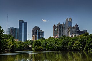
Midtown Atlanta, or Midtown, is a high-density commercial and residential neighborhood of Atlanta, Georgia. The exact geographical extent of the area is ill-defined due to differing definitions used by the city, residents, and local business groups. However, the commercial core of the area is anchored by a series of high-rise office buildings, condominiums, hotels, and high-end retail along Peachtree Street between North Avenue and 17th Street. Midtown, situated between Downtown to the south and Buckhead to the north, is the second-largest business district in Metro Atlanta. In 2011, Midtown had a resident population of 41,681 and a business population of 81,418.
The Atlanta BeltLine is a former railway corridor around the core of Atlanta, Georgia, under development in stages as a multi-use trail. Some portions are already complete, while others are still in a rough state but hikeable. Using existing rail track easements, the BeltLine is designed to improve transportation, add green space, and promote redevelopment. There are longer-term visions for streetcar or light-rail lines along all or part of the corridor.
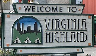
Virginia–Highland is an affluent neighborhood of Atlanta, Georgia, founded in the early 20th century as a streetcar suburb. It is named after the intersection of Virginia Avenue and North Highland Avenue, the heart of its trendy retail district at the center of the neighborhood. The neighborhood is famous for its bungalows and other historic houses from the 1910s to the 1930s. It has become a destination for people across Atlanta with its eclectic mix of restaurants, bars, and shops as well as for the Summerfest festival, annual Tour of Homes and other events.

The Great Atlanta Fire of 1917 began just after noon on 21 May 1917 in the Old Fourth Ward of Atlanta, Georgia. It is unclear just how the fire started, but it was fueled by hot temperatures and strong winds which propelled the fire. The fire, which burned for nearly 10 hours, destroyed 300 acres (120 ha) and 1,900 structures displacing over 10,000 people. Damages were estimated at $5 million,.

Clear Creek is a stream in northeast Atlanta that is a tributary to Peachtree Creek and part of the Chattahoochee River watershed. It has two main branches, one originating east of the high ground along which Boulevard runs and another to the west originating on the northeast side of downtown Atlanta. The easterly branch of Clear Creek begins in several springs and branches in what are now Inman Park and the Old Fourth Ward. Flowing north, the creek was joined by other branches and springs, including Angier Springs near the end of Belgrade Avenue and the so-called Ponce de Leon Springs, which were “discovered” during railroad construction in the 1860s and gave rise to the eponymous park and avenue.

The Old Fourth Ward, often abbreviated O4W, is an intown neighborhood on the eastside of Atlanta, Georgia, United States. The neighborhood is best known as the location of the Martin Luther King Jr. historic site.

Ponce de Leon Avenue, often simply called Ponce, provides a link between Atlanta, Decatur, Clarkston, and Stone Mountain, Georgia. It was named for Ponce de Leon Springs, in turn from explorer Juan Ponce de León, but is not pronounced as in Spanish. Several grand and historic buildings are located on the avenue.

North Avenue is a major avenue in Atlanta, Georgia that divides Downtown Atlanta from Midtown Atlanta. North Avenue stretches continuously in Atlanta from Candler Park in the east, across Interstate 75 & Interstate 85, along the southern boundary of the Georgia Institute of Technology, to Joseph E. Lowery Boulevard just southwest of Georgia Tech, where it ends. North Avenue passes through the neighborhoods of Poncey-Highland, Old Fourth Ward, and Midtown Atlanta.
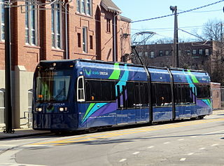
The Atlanta Streetcar or Downtown Loop is a streetcar line in Atlanta, Georgia, United States.

Streetcars originally operated in Atlanta downtown and into the surrounding areas from 1871 until the final line's closure in 1949.
In Atlanta, Georgia, trolleybuses, generally called trackless trolleys there, were a major component of the public transportation system in the middle decades of the 20th century, carrying some 80 percent of all transit riders during the period when the system was at its maximum size. At the end of 1949 Atlanta had a fleet of 453 trolleybuses, the largest in the United States, and it retained this distinction until 1952, when it was surpassed by Chicago.

The Ponce de Leon amusement park was built on the site of Ponce de Leon Springs. Omnibus service from Atlanta to the springs started in 1872, and in 1874 horsecar service started. It developed in the late 1880s and 1890s with the addition of attractions for children, a dance hall and theater, and picnic grounds. In 1903 construction of the full-fledged amusement park began. By then the park was served by the Nine-Mile Circle electric streetcar line.
Ponce de Leon Springs were natural springs located on the site of Ponce City Market in Atlanta, where Ponce de Leon Avenue crosses the BeltLine, and where the Old Fourth Ward, Virginia Highland, Midtown and Poncey-Highland neighborhoods of Atlanta meet.

Atkins Park is an intown neighborhood of Atlanta, Georgia, nestled against the southeast corner of the neighborhood of Virginia-Highland, west of Briarcliff Avenue and north of Ponce de Leon Avenue ("Ponce"). It consists of just three streets - St. Louis Place, St. Charles Place, and St. Augustine Place - as well as an internal sidewalk known as Malcolm's Way that bisects them from St. Charles to St. Louis. It was originally designed to give quicker access to the streetcar stop at Ponce.
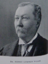
Dr. Henry Lumpkin Wilson was a prominent Atlanta physician, city councilman, and was active in the city's expansion and development.
The History of Virginia–Highland, the Intown Atlanta neighborhood, dates back to 1812, when William Zachary bought and built a farm on 202.5 acres (0.819 km2) of land there. At some point between 1888 and 1890 the Nine-Mile Circle streetcar arrived,, making a loop of what are now Ponce de Leon Avenue, North Highland Avenue, Virginia Avenue, and Monroe Drive. Atlantans at first used the line to visit what was then countryside, including Ponce de Leon Springs, but the line also enabled later development in the area. Residential development began as early as 1893 on St. Charles and Greenwood Avenues, must most development took place from 1909 through 1926 — solidly upper-middle class neighborhoods, kept all-white by covenant.
The Atlanta neighborhood of Virginia–Highland is one of many intown Atlanta neighborhoods characterized by commercial space of two sorts:

Highland Avenue, east of the BeltLine North Highland Avenue, is a major thoroughfare in northeast Atlanta, forming a major business corridor connecting five Intown neighborhoods:

