The Atlanta BeltLine is a 22 miles (35 km) open and planned loop of multi-use trail and light rail transit system on a former railway corridor around the core of Atlanta, Georgia. The Atlanta BeltLine is designed to reconnect neighborhoods and communities historically divided and marginalized by infrastructure, improve transportation, add green space, promote redevelopment, create and preserve affordable housing, and showcase arts and culture. The project is in varying stages of development, with several mainline and spur trails complete and others in an unpaved, but hikeable, state. Since the passage of the More MARTA sales tax in 2016, construction of the light rail streetcar system is overseen by MARTA in close partnership with Atlanta BeltLine, Inc.

The Sweet Auburn Historic District is a historic African-American neighborhood along and surrounding Auburn Avenue, east of downtown Atlanta, Georgia, United States. The name Sweet Auburn was coined by John Wesley Dobbs, referring to the "richest Negro street in the world," one of the largest concentrations of African-American businesses in the United States.

West End is a historic neighborhood in the U.S. city of Atlanta, one of the oldest outside Downtown Atlanta, and is listed on the National Register of Historic Places. West End residents are primarily (86%) African American and the neighborhood contains several prominent African American cultural institutions, in addition to being adjacent to the Atlanta University Center complex of HBCUs. West End is located southwest of Castleberry Hill, east of Westview, west of Adair Park Historic District, and just north of Oakland City. Architectural styles within the district include Craftsman Bungalow, Queen Anne, Stick style, Folk Victorian, Colonial Revival, American Foursquare and Neoclassical Revival.

Jackson Ward, previously known as Central Wards, is a historically African-American district in Richmond, Virginia, with a long tradition of African-American businesses. It is located less than a mile from the Virginia State Capitol, sitting to the west of Court End and north of Broad Street. It was listed as a National Historic Landmark District in 1978. "Jackson Ward" was originally the name of the area's political district within the city, or ward, from 1871 to 1905, yet has remained in use long after losing its original meaning.

Clear Creek is a stream in northeast Atlanta that is a tributary to Peachtree Creek and part of the Chattahoochee River watershed. It has two main branches, one originating east of the high ground along which Boulevard runs and another to the west originating on the northeast side of downtown Atlanta. The easterly branch of Clear Creek begins in several springs and branches in what are now Inman Park and the Old Fourth Ward. Flowing north, the creek was joined by other branches and springs, including Angier Springs near the end of Belgrade Avenue and the so-called Ponce de Leon Springs, which were “discovered” during railroad construction in the 1860s and gave rise to the eponymous park and avenue.

The Old Fourth Ward, often abbreviated O4W, is an intown neighborhood on the eastside of Atlanta, Georgia, United States. The neighborhood is best known as the location of the Martin Luther King Jr. historic site.

Ponce de Leon Avenue, often simply called Ponce, provides a link between Atlanta, Decatur, Clarkston, and Stone Mountain, Georgia. It was named for Ponce de Leon Springs, in turn from explorer Juan Ponce de León, but is not pronounced as in Spanish. Several grand and historic buildings are located on the avenue.

Adair Park is a residential neighborhood located southwest of downtown Atlanta. It has the form of a left curly bracket, bordered by the MARTA north–south rail line on the northwest, the BeltLine trail on the southwest and Metropolitan Parkway on the east. Historically Adair Park also included the area from Metropolitan Parkway to McDaniel Street on the east, but the city now considers that area part of the Pittsburgh neighborhood.
West Midtown, also known as Westside, is a colloquial area, comprising many historical neighborhoods located in Atlanta, Georgia. Once largely industrial, West Midtown is now the location of urban lofts, art galleries, live music venues, retail and restaurants.
Buttermilk Bottom, also known as Buttermilk Bottoms or Black Bottom, was an African-American neighborhood in central Atlanta, centered on the area where the Atlanta Civic Center now stands in the Old Fourth Ward. It was considered a slum area, having unpaved streets and no electricity.

Chosewood Park is a neighborhood in southeast Atlanta, Georgia in the United States. It is located south of Peoplestown and Grant Park, west of Boulevard Heights and Benteen Park, northwest of Thomasville Heights and the Atlanta federal penitentiary, and northeast of South Atlanta and Lakewood Heights. It is situated directly on the path of the Atlanta Beltline, which has begun to acquire and develop properties along the rail lines in the Chosewood corridor, including the Boulevard Crossing Park.
Benteen Park is a neighborhood in southeast Atlanta, Georgia, bounded on the west by Boulevard and the Chosewood Park neighborhood, on the north by Boulevard Heights, on the east by Custer/McDonough/Gulce and on the south by Atlanta Federal Prison, which also lies in the Benteen Park neighborhood.

Historic Fourth Ward Park is a park built on the site of the old Ponce de Leon amusement park, in the Old Fourth Ward of Atlanta, just south of Ponce City Market and just west of the BeltLine Eastside Trail.

English Avenue and Vine City are two adjacent and closely linked neighborhoods of Atlanta, Georgia. Together the neighborhoods make up neighborhood planning unit L. The two neighborhoods are frequently cited together in reference to shared problems and to shared redevelopment schemes and revitalization plans.
Lindbergh, officially Lindbergh/Morosgo, is a neighborhood in the Buckhead district of Atlanta, Georgia. Most of the neighborhood consists of multi-use development combining retail, office and residential space.
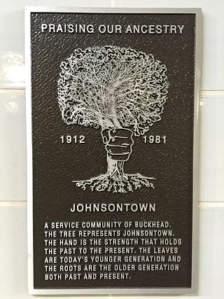
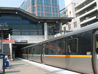
Johnsontown was a settlement in what is now the Buckhead Community of Atlanta, Georgia which was located on the present site of the Lenox MARTA station. It was settled by African Americans in 1912. Until 1982 approximately thirty families lived here on 23-foot (7.0 m) by 143-foot (44 m) lots, until the land was acquired to build the rapid transit station.

Gentrification of Atlanta's inner-city neighborhoods began in the 1970s, and it has continued, at varying levels of intensity, into the present. Many factors have contributed to the city's gentrification. A major increase in gentrification that occurred in the last years of the twentieth century has been attributed to the 1996 Summer Olympics. However, during the 2000s, Atlanta underwent a profound transformation demographically, physically, and culturally. Suburbanization, rising prices, a booming economy, and new migrants decreased the city’s black percentage from a high of 67% in 1990 to 54% in 2010. From 2000 to 2010, Atlanta gained 22,763 white residents, 5,142 Asian residents, and 3,095 Hispanic residents, while the city’s black population decreased by 31,678. Much of the city’s demographic change during the decade was driven by young, college-educated professionals: from 2000 to 2009, the three-mile radius surrounding Downtown Atlanta gained 9,722 residents aged 25 to 34 holding at least a four-year degree, an increase of 61%. Between the mid-1990s and 2010, stimulated by funding from the HOPE VI program, Atlanta demolished nearly all of its public housing, a total of 17,000 units and about 10% of all housing units in the city. In 2005, the $2.8 billion BeltLine project was adopted, with the stated goals of converting a disused 22-mile freight railroad loop that surrounds the central city into an art-filled multi-use trail and increasing the city’s park space by 40%. Lastly, Atlanta’s cultural offerings expanded during the 2000s: the High Museum of Art doubled in size; the Alliance Theatre won a Tony Award; and numerous art galleries were established on the once-industrial Westside.

Edgewood Avenue is a street in Atlanta, Georgia, United States which runs from Five Points in Downtown Atlanta, eastward through the Old Fourth Ward. The avenue runs in the direction of the Edgewood neighborhood, and stops just short of it in Inman Park. Edgewood Avenue was first important as the route of a streetcar line to Inman Park, Atlanta's first garden suburb and home to many of its most prominent citizens. Today, the avenue is known for its restaurants and nightlife around its intersection with Boulevard.


