Related Research Articles
East Atlanta is a neighborhood on the east side of Atlanta, Georgia, United States The name East Atlanta Village primarily refers to the neighborhood's commercial district.

Grove Park is a northwest Atlanta, inside-the-perimeter neighborhood bounded by:
Loring Heights is a neighborhood of just over 300 homes located in south Buckhead neighborhood of Atlanta, nestled between Peachtree Street,on the east, Northside Drive on the west, and Atlantic Station to the south. The neighborhood provides relatively easy access to I-75/85, GA 400, and I-285.

Berkeley Park is a neighborhood located in West Midtown Atlanta, Georgia, United States.
Ormewood Park is a neighborhood on the east side of Atlanta, Georgia, United States.

Capitol View is an in-town Atlanta neighborhood 2.5 miles from downtown Atlanta, Georgia that was named for its excellent view of the Georgia State Capitol building. Its boundaries include Metropolitan Parkway to the east, Lee Street to the west, and the Beltline to the north. On the south, the border follows Arden Street, Deckner Avenue, and Perkerson Park. Its central location is only minutes away from Atlanta Downtown Atlanta, Midtown Atlanta, Buckhead, College Park, East Point, Hartsfield-Jackson Atlanta International Airport, and major highways and interstates such as the Downtown Connector/I-75/I-85, I-20, and Metropolitan Parkway.
The Perkerson neighborhood is located in Southwest Atlanta, Georgia in NPU-X. The name change was made by request of residents/members of the Perkerson Civic Association (PCA) in order to keep people from confusing the neighborhood with Perkerson Park which is the large park that serves the area.

South Downtown is a historic neighborhood of Downtown Atlanta, Georgia, United States. South Downtown is primarily home to city, county, state, and federal governmental offices, which prompted the city to adopt signage declaring the area "Government Walk." Although much of South Downtown is dominated by surface parking lots, the neighborhood was passed over during the redevelopment boom of the 1960s and 1970s that resulted in the demolition of much of Downtown's architecturally significant buildings. The result is myriad buildings from the 1950s and earlier that retain their historic structural integrity.
West Midtown, also known as Westside, is a colloquial area, comprising many historical neighborhoods located in Atlanta, Georgia. Once largely industrial, West Midtown is now the location of urban lofts, art galleries, live music venues, retail and restaurants.
Paces is a neighborhood of Atlanta. It is part of the Buckhead district and located in the far northwest corner of the city. Paces is bounded on the northwest by the Chattahoochee River, which is also the Cobb/Fulton county line. Just across the river in Cobb is the unincorporated community of Vinings, which was originally known as Paces after founder Hardy Pace, who operated Pace's Ferry. Cumberland is also located on the other side of the river. It is perhaps Atlanta's most affluent neighborhood, with many of the homes selling in the $5–$7 million range, and some reaching upwards of $20 million.
Lindridge/Martin Manor is an intown neighborhood of Atlanta, Georgia. It consists mostly of the single-family homes located off Lindbergh Drive in between I-85 and Cheshire Bridge Road. In addition, it includes a small commercial area of three streets west of I-85 bounded by Peachtree Creek, Piedmont Road and the Southern railroad. The neighborhood's boundaries are I-85 on the northwest, Morningside-Lenox Park on the south, and North Druid Hills in unincorporated DeKalb County, Georgia on the east.

Lakewood Heights is a Black neighborhood in southeast Atlanta. It is bounded by:
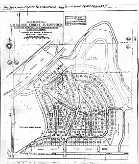
Sherwood Forest is an intown neighborhood of Atlanta, Georgia, bordered by the Ansley Park neighborhood on the south and east, and on the northwest by the Downtown Connector across which is the Brookwood Hills neighborhood. It was established in 1949. It is one of the most affluent neighborhoods of the city with an average single-family home price of $951,376 in 2008.
Lindbergh, officially Lindbergh/Morosgo, is a neighborhood in the Buckhead district of Atlanta, Georgia. Most of the neighborhood consists of multi-use development combining retail, office and residential space.
Brookwood is a neighborhood at the southernmost tip of the Buckhead Community of Atlanta. It should not be confused with Brookwood Hills, a neighborhood and historic district east of Brookwood across Peachtree Road.
Peachtree Hills is a neighborhood within the Buckhead district of Atlanta, Georgia. It primarily contains residential buildings, however, commercial buildings are scattered throughout the neighborhood. Peachtree Battle Shopping Center is located within the borders of Peachtree Hills.
Greenbriar is a middle-class neighborhood of southwestern Atlanta, Georgia. Greenbriar is a long strip along the east side of the Perimeter (I-285) stretching from Langford Parkway to just south of Stone Road. It is bordered by Atlanta's "Southwest" neighborhood across Langford Parkway to the north, Ben Hill Forest across the Perimeter to the west, and by the city of East Point on the east and south.
Carey Park is a neighborhood on the Upper Westside of Atlanta with a population of 1,739.
Dixie Hills is a historic neighborhood of northwest Atlanta with a population of 1,756 (2010).
Venetian Hills is an official neighborhood in southwest Atlanta, in the U.S. state of Georgia. Its 2010 population was 3,790.
References
- ↑ "Google Maps". Google Maps. Retrieved 15 October 2017.