East Atlanta is a neighborhood on the east side of Atlanta, Georgia, United States. The name East Atlanta Village primarily refers to the neighborhood's commercial district.

Poncey–Highland is an intown neighborhood on the east side of Atlanta, Georgia, located south of Virginia–Highland. It is so named because it is near the intersection of east/west Ponce de Leon Avenue and north/southwest North Highland Avenue. This Atlanta neighborhood was established between 1905 and 1930, and is bordered by Druid Hills and Candler Park across Moreland Avenue to the east, the Old Fourth Ward across the BeltLine Eastside Trail to the west, Inman Park across the eastern branch of Freedom Parkway to the south, and Virginia Highland to the north across Ponce de Leon Avenue. The Little Five Points area sits on the border of Poncey–Highland, Inman Park, and Candler Park.

Grove Park is a northwest Atlanta, inside-the-perimeter neighborhood bounded by:
Edgewood is a neighborhood located on the east side of Atlanta, Georgia, United States, located approximately 3 miles (4.8 km) east of downtown Atlanta.
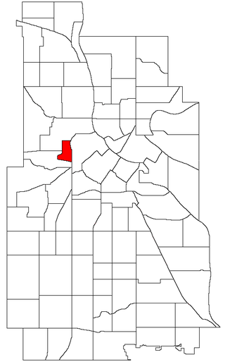
Sumner-Glenwood is a neighborhood in the Near North community of Minneapolis.

Clear Creek is a stream in northeast Atlanta that is a tributary to Peachtree Creek and part of the Chattahoochee River watershed. It has two main branches, one originating east of the high ground along which Boulevard runs and another to the west originating on the northeast side of downtown Atlanta. The easterly branch of Clear Creek begins in several springs and branches in what are now Inman Park and the Old Fourth Ward. Flowing north, the creek was joined by other branches and springs, including Angier Springs near the end of Belgrade Avenue and the so-called Ponce de Leon Springs, which were “discovered” during railroad construction in the 1860s and gave rise to the eponymous park and avenue.
Capitol View Manor is a small community in Southwest Atlanta that was named for the excellent view of the Georgia State Capitol building. Its boundaries include I-75/85 to the east, the Beltline to the north, Metropolitan Parkway to the west, and Atlanta Technical College to the south.

Westview is a historic intown neighborhood located in southwest Atlanta, Georgia. It is named for the Westview Cemetery that borders the neighborhood to the northwest. The neighborhood is made up of a mixture of architectural styles including Arts & Crafts bungalows, Four-Squares, Tudors, Minimal Traditional houses, and Ranch style houses.
East Lake is a neighborhood on the east side of Atlanta, Georgia, situated in DeKalb County. It is the easternmost of the 238 neighborhoods in the City of Atlanta. It is home to East Lake Golf Club, the site of PGA's annual Tour Championship. East Lake lies mostly within the 30317 zip code.
Ormewood Park is a neighborhood on the east side of Atlanta, Georgia, United States.

Capitol View is a historic in-town southwest Atlanta neighborhood 2.5 miles from downtown Atlanta, Georgia that was named for its view of the Georgia State Capitol building. Its boundaries include Metropolitan Parkway to the east, Lee Street to the west, and the Beltline to the north. On the south, the border follows Arden Street, Deckner Avenue, and Perkerson Park.

Adair Park is a residential neighborhood located southwest of downtown Atlanta. It has the form of a left curly bracket, bordered by the MARTA north–south rail line on the northwest, the BeltLine trail on the southwest and Metropolitan Parkway on the east. Historically Adair Park also included the area from Metropolitan Parkway to McDaniel Street on the east, but the city now considers that area part of the Pittsburgh neighborhood.
North Ormewood Park is a neighborhood on the east side of Atlanta, Georgia, United States, located in the northern part of Ormewood Park. It is located between Reynoldstown, East Atlanta and Grant Park and adjacent to the mixed-use development Glenwood Park. It is bordered by Moreland Avenue, Glenwood Avenue, I-20 and Stovall Avenue. It is a designated Drug Free Commercial Zone.
Riverside is an intown neighborhood located on the Upper Westside of Atlanta. It is so named because it is situated along the Chattahoochee River.
Hunter Hills is a neighborhood located west of downtown Atlanta, Georgia, United States. Its motto, "One Community, One Family", has been its cornerstone since 2001. The neighborhood is encompassed in the 30314 zip code. Hunter Hills shares borders with Mozley Park, Dixie Hills and West Lake neighborhoods. The neighborhood rests just inside Atlanta's perimeter highway I-285, and U.S. Route 78. The schools that serve the neighborhood are Stanton Elementary, Carter G. Woodson Elementary School, Ron Clark Academy, Herndon Elementary and Washington High School, and the Atlanta Job Corps. City of Refuge, a community-based 501(c)(3) non-profit, was established on the 1300 block of Joseph E. Boone Blvd. in 2003 and helps to bring transformation to individuals and families through services including housing, health and wellness, vocational training, and youth development.
Lindridge/Martin Manor is an intown neighborhood of Atlanta, Georgia. It consists mostly of the single-family homes located off Lindbergh Drive in between I-85 and Cheshire Bridge Road. In addition, it includes a small commercial area of three streets west of I-85 bounded by Peachtree Creek, Piedmont Road and the Southern railroad. The neighborhood's boundaries are I-85 on the northwest, Morningside-Lenox Park on the south, and North Druid Hills in unincorporated DeKalb County, Georgia on the east.

South Atlanta is an officially defined neighborhood of the city of Atlanta within the city's south side. It is bounded on the northeast by the railroad and the Chosewood Park neighborhood; on the northwest by the railroad and the BeltLine and the Peoplestown neighborhood, on the west by High Point and the Villages at Carver, and on the south mostly by Turman Street and the Lakewood Heights neighborhood.
Lindbergh, officially Lindbergh/Morosgo, is a neighborhood in the Buckhead district of Atlanta, Georgia. Most of the neighborhood consists of multi-use development combining retail, office and residential space.
Brookwood is a neighborhood at the southernmost tip of the Buckhead Community of Atlanta. It should not be confused with Brookwood Hills, a neighborhood and historic district east of Brookwood across Peachtree Road.

Ardmore, sometimes called "Ardmore Park" for the city park of the same name within the neighborhood, is a neighborhood in the extreme south Buckhead area of Atlanta, between Peachtree Road, on the east, railroad tracks and the Atlanta BeltLine on the west, Collier Road to the north and Brookwood to the south. Though distinct from Brookwood and Collier Hills, the neighborhoods are often linked as they share a border and location along Collier Road and Peachtree Street/Road just north of Midtown.


