Cascade Heights

Last updated

Cascade Springs Nature Preserve, a park in Cascade Heights Cascade Springs Nature Preserve boardwalk, Atlanta, Dec 2018 1.jpg
Cascade Springs Nature Preserve, a park in Cascade Heights

Cascade Heights is an affluent neighborhood in southwest Atlanta. It is bisected by Cascade Road, which was known as the Sandtown Road in the nineteenth century. The road follows the path of the ancient Sandtown Trail which ran from Stone Mountain to the Creek village of Sandtown on the Chattahoochee River and from there on into Alabama. Ironically, the name lived on even after the Indians were expelled in the 1830s. [1]

Contents

After the Indian cession, settlement came quickly, and several roads in the area bear the names of early pioneers, including Willis Mill Road, Childress Drive, Herring Road, Dodson Drive, Head Road, and Sewell Road, since rechristened Benjamin Mays Boulevard. Part of "Stone's District" in the nineteenth century, the area was dotted with small farms of white farming families, only a few of which were also home to enslaved African Americans. [2] By the time of the Civil War there was a post office at Utoy where the Sandtown Road crossed Utoy Creek but no real community center aside from the post office, churches, and mills. Utoy Primitive Baptist Church and Mt. Gilead Methodist Church were both organized in 1824 and flourished throughout the nineteenth and into the twentieth century. In the nineteenth century, the revival camp meetings held at Mt. Gilead campground near Ben Hill from 1835 until 1989 drew thousands from all denominations in the area. Willis' Mill on the south fork of Utoy Creek and Herring's Mill on the north fork were critical for not only grinding corn and sawing lumber, but also for the chance to socialize. A cotton gin also operated on a site just west of what is now the Cascade Nature Preserve, and it also would have been a place that nearly everyone in the area used at one time or another. [3]

In early 1864, as the prospect of invasion by the Union army became real, defensive works were built that encircled Atlanta a mile and a half or so from the city center. As the Confederate army was pushed steadily before General Sherman's army in the spring of 1864, there were frantic attempts to extend the fortifications, including one line built southwest of the city along the Sandtown Road. After the Confederate defeat at Kennesaw Mountain, the Union army's crossing of the Chattahoochee River in early July was followed by three awful battles fought later that month: the Battle of Peachtree Creek, north of the city, the so-called Battle of Atlanta on the east, and the Battle of Ezra Church on the west on July 27. During August, as Union artillery laid siege to the city, there were skirmishes all around the southwest side of the city as Sherman attempted to complete his encirclement of the city. On August 4–7, the Union and Confederate armies met at the Battle of Utoy Creek, fought in and around what is now the Cascade Nature Preserve. Union losses were put at 850, and the Confederate line held with a loss of only 35 killed, wounded, or missing.

The area remained mostly rural farmland throughout the nineteenth century, Cascade Springs was one of several sites around the city hoping to cash in on the rising middle class. Ponce de Leon Springs was the most successful perhaps, but in the springs near the old ford for the Sandtown Road over Turkeyfoot Creek was the genesis of Cascade Heights, or simply Cascade. The springs were christened "Cascade" after the three small waterfalls that spill away from the road, now in the northeast corner of the Cascade Spring Nature Preserve. A small resort developed there in the late nineteenth and early twentieth centuries. Very little remains besides an exceptionally fine spring house sheltering the original spring.

Today the term Cascade, much like the term Midtown, can refer to a much larger area than what might be shown on official maps. Generally today Cascade might be bounded by I-20 on the north, I-285 on the west, the ridges on the south side of Utoy Creek, and the pre-1954 city limits around Greenwood Cemetery. In the period between the world wars, Adams Park and Beecher Hills began to develop, and after World War II, explosive suburban growth produced Audubon Forest, Peyton Forest, West Manor, Sewell Manor, and Mangum Manor as the old farms in this part of Fulton County were subdivided and developed in the 1950s. In 1953, the area was annexed into the City of Atlanta.

Peyton Road Affair

In the early 1960s the area was a predominantly white neighborhood. After an African-American physician (Dr. Clinton E. Warner) bought a home in Peyton Forest, white residents in the area feared that their neighborhood would become a victim of blockbusting, [4] [5] a business practice in which real estate agents would profit from the racial fears of white residents while changing the racial makeup of a white residential area. When African Americans moved into a neighborhood, many whites believed that property values would automatically plunge, which was a self-fulfilling prophecy as so many homes went on the market at the same time as whites fled first West End and then Cascade Heights, Adams Park, and most of the rest of southwest Atlanta. Real estate agents stirred up racial tension and benefited from the commissions they earned when fearful homeowners sold their properties, often at a loss, in order to escape the area.

In an infamous 1962–63 episode that came to be called "the Peyton Road Affair", Atlanta mayor Ivan Allen responded to residents' fears of blockbusting by directing city staff to erect barricades on Peyton Road and Harlan Road to restrict access to Cascade Heights, thus preventing African-American homeseekers from getting to the neighborhood from Gordon Road (now MLK Drive). [5] [6] [7] [8] He took the action at the urging of white residents of southwest Atlanta [6] (in particular, one of his high-level employees who lived a short distance from Peyton Road[ citation needed ]). After the barricades went up, December 18, 1962, [9] the incident quickly drew national attention. The barrier was compared to the Berlin Wall and nicknamed the "Atlanta Wall". [6] [7] Some newspapers in other parts of the country questioned Atlanta's motto "the City Too Busy to Hate". The walls were torn down when, on March 1, 1963, a court ruled them to be unconstitutional. [4] [5] [6] [7] White homeowners fled the neighborhood after the barricades were removed. By the end of July 1963, only 15 white homeowners remained in Peyton Forest. [10]

By the late 1960s the Cascade Heights neighborhood was predominantly African-American. In the 1970s, the area became home to many affluent African-American business professionals, college professionals, celebrities, former pro-athletes, and elected officials and it remains so today. A private school K-12th grade education is most common for children living in the Cascade Heights area. The area experienced some notable decline in the late 20th and early 21st century partly due to many middle-class and upper-middle-class African Americans in Atlanta moving to the suburbs for newer constructed homes or lower crime. Since 2018, many desired improvements have come to the area since interest in city living has become popular again. [11] [12] Also since 2018, Cascade Heights began to increase in racial diversity and higher income individuals again due to its proximity to downtown, the Hartsfield–Jackson International Airport, and having some of the most affordable renovated large homes within the city limits. [13]

Notable people

Notable current and former residents of Cascade Heights include:

Related Research Articles

<span class="mw-page-title-main">Fulton County, Georgia</span> County in Georgia, United States

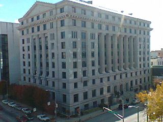
Fulton County is a county in the north-central portion of the U.S. state of Georgia. As of the 2020 United States census, the population was 1,066,710, making it the state's most populous county and its only one with over one million inhabitants. Its county seat and most populous city is Atlanta, the state capital. About 90% of the City of Atlanta is within Fulton County; the remaining portion is in DeKalb County. Fulton County is part of the Atlanta–Sandy Springs–Roswell, GA Metropolitan Statistical Area.

<span class="mw-page-title-main">Decatur, Georgia</span> City in Georgia, United States

Decatur is a city in, and the county seat of, DeKalb County, Georgia, United States, part of the Atlanta metropolitan area. With a population of 24,928 in the 2020 census, the municipality is sometimes assumed to be larger since multiple ZIP Codes in unincorporated DeKalb County bear Decatur as the address. The city is served by three MARTA rail stations. The city is located approximately five miles northeast of Downtown Atlanta and shares its western border with both the city of Atlanta and unincorporated DeKalb County. The Druid Hills neighborhood is to the northwest of Decatur.

<span class="mw-page-title-main">History of Atlanta</span>

The history of Atlanta dates back to 1836, when Georgia decided to build a railroad to the U.S. Midwest and a location was chosen to be the line's terminus. The stake marking the founding of "Terminus" was driven into the ground in 1837. In 1839, homes and a store were built there and the settlement grew. Between 1845 and 1854, rail lines arrived from four different directions, and the rapidly growing town quickly became the rail hub for the entire Southern United States. During the American Civil War, Atlanta, as a distribution hub, became the target of a major Union campaign, and in 1864, Union William Sherman's troops set on fire and destroyed the city's assets and buildings, save churches and hospitals. After the war, the population grew rapidly, as did manufacturing, while the city retained its role as a rail hub. Coca-Cola was launched here in 1886 and grew into an Atlanta-based world empire. Electric streetcars arrived in 1889, and the city added new "streetcar suburbs".

The city of Atlanta, Georgia is made up of 243 neighborhoods officially defined by the city. These neighborhoods are a mix of traditional neighborhoods, subdivisions, or groups of subdivisions. The neighborhoods are grouped by the city planning department into 25 neighborhood planning units (NPUs). These NPUs are "citizen advisory councils that make recommendations to the Mayor and City Council on zoning, land use, and other planning issues". There are a variety of other widely recognized named areas within the city. Some are officially designated, while others are more informal.

East Atlanta is a neighborhood on the east side of Atlanta, Georgia, United States. The name East Atlanta Village primarily refers to the neighborhood's commercial district.

The Battle of Utoy Creek was fought August 4–7, 1864, during the Atlanta Campaign of the American Civil War. Maj. Gen. William T. Sherman's Union armies had partially encircled the city of Atlanta, Georgia, which was being held by Confederate forces under the command of General John Bell Hood. Sherman had at this point adopted a strategy of attacking the railroad lines into Atlanta, hoping to cut off his enemies' supplies. This was the third direct attack on Confederate positions during the campaign and the effect of success would have ended the siege and won Atlanta on 6 August 1864.

The neighborhood planning unit (NPU) is a community-scale governmental structure used in the City of Atlanta, Georgia.

Sandtown is a neighborhood located southwest of Atlanta, Georgia.

There were several historic mills around the metro Atlanta area, for which many of its current-day roads are still named. Most of the mills date back to the 1820s and 1830s, and were built along the area's many streams. The locations of many of these mills are shown on a map of 1875 showing U. S. military operations around Atlanta in 1864. This map is now located in the U. S. Library of Congress but can be seen on the webpage linked here.

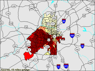
From its incorporation in 1847, the municipal boundaries of Atlanta, Georgia, United States, were extended repeatedly from a small area around its railroad station to today's city covering 131.7 square miles (341 km2).

Historic Collier Heights is an historically middle-class and predominately African-American populated historic area in the northwest corner of Atlanta, Georgia. It is bordered to the west by Fairburn Road, the east by Hamilton E. Holmes Drive, the north by Donald L. Hollowell Parkway, and to the south by Interstate 20 bridge at Linkwood Road.

<span class="mw-page-title-main">South Fulton, Georgia</span> City in Georgia, United States

South Fulton is a city in Fulton County, Georgia, United States in the Atlanta metropolitan area. It was incorporated in 2017 from parts of southwest Fulton County and includes the communities of Red Oak, Cooks Crossing, Stonewall, Fife, Ben Hill, Sandtown, Cliftondale, Ono, Cedar Grove, Boat Rock/Dry Pond, Maude, Lester, Enon, Welcome All, Peters Woods, and part of Campbellton. As of 2020, it had a population of 107,436, making it the state's eighth-largest city in population. Also as of 2020, South Fulton has the highest African-American percentage of any U.S. city over 100,000, surpassing highly African-American cities such as Detroit and Jackson.

<span class="mw-page-title-main">African Americans in Atlanta</span> African Americans living in Atlanta, USA

Black Atlantans form a major population group in the Atlanta metropolitan area, encompassing both those of African-American ancestry as well as those of recent Caribbean or African origin. Atlanta has long been known as a center of black entrepreneurship, higher education, political power and culture; a cradle of the Civil Rights Movement.

<span class="mw-page-title-main">Gentrification of Atlanta</span> Gentrification of Atlantas inner-city neighborhoods

Gentrification of Atlanta's inner-city neighborhoods began in the 1970s, and it has continued, at varying levels of intensity, into the present. Many factors have contributed to the city's gentrification. A major increase in gentrification that occurred in the last years of the 20th century has been attributed to the 1996 Summer Olympics. However, during the 2000s, Atlanta underwent a profound transformation demographically, physically, and culturally. Suburbanization, rising prices, a booming economy, and new migrants decreased the city’s black percentage from a high of 67% in 1990 to 54% in 2010. From 2000 to 2010, Atlanta gained 22,763 white residents, 5,142 Asian residents, and 3,095 Hispanic residents, while the city’s black population decreased by 31,678. Much of the city’s demographic change during the decade was driven by young, college-educated professionals: from 2000 to 2009, the three-mile radius surrounding Downtown Atlanta gained 9,722 residents aged 25 to 34 holding at least a four-year degree, an increase of 61%. Between the mid-1990s and 2010, stimulated by funding from the HOPE VI program, Atlanta demolished nearly all of its public housing, a total of 17,000 units and about 10% of all housing units in the city. In 2005, the $2.8 billion BeltLine project was adopted, with the stated goals of converting a disused 22-mile freight railroad loop that surrounds the central city into an art-filled multi-use trail and increasing the city’s park space by 40%. Lastly, Atlanta’s cultural offerings expanded during the 2000s: the High Museum of Art doubled in size; the Alliance Theatre won a Tony Award; and numerous art galleries were established on the once-industrial Westside.

Racial segregation in Atlanta has known many phases after the freeing of the slaves in 1865: a period of relative integration of businesses and residences; Jim Crow laws and official residential and de facto business segregation after the Atlanta Race Riot of 1906; blockbusting and black residential expansion starting in the 1950s; and gradual integration from the late 1960s onwards. A 2015 study conducted by Nate Silver of fivethirtyeight.com, found that Atlanta was the second most segregated city in the U.S. and the most segregated in the South.

The Cascade Mansion is the name of an antebellum home built in south west Atlanta, Georgia, south of the Sandtown, and was

<span class="mw-page-title-main">Utoy, Georgia</span>

Utoy, Georgia was a small village located along Utoy Creek in present-day Fulton County, Georgia, USA. The vicinity, now part of metropolitan Atlanta, was the scene of the August 1864 Battle of Utoy Creek during the American Civil War and is today the site of Utoy Indian Village, a tourist center with renditions of historic Native-American structures and which offers a "Civil War Battlefield Tour."

Venetian Hills is an official neighborhood in southwest Atlanta, in the U.S. state of Georgia. Its 2010 population was 3,790. The neighborhood was established in the late 1950s.

<span class="mw-page-title-main">Utoy Cemetery</span> Historic cemetery in Atlanta, Georgia, US

Utoy Cemetery is one of the oldest cemeteries within the current city limits of Atlanta in the U.S. state of Georgia and is listed on the National Register of Historic Places. Located near the intersection of Venetian Drive SW and Cahaba Drive SW in the Venetian Hills neighborhood in southwest Atlanta, it was used for burials as early as 1828.

<span class="mw-page-title-main">Atlanta's Berlin Wall</span> Event during the civil rights movement in Atlanta, Georgia, U.S., in 1962

Atlanta's Berlin Wall, also known as the Peyton Road Affair or the Peyton Wall, refers to an event during the civil rights movement in Atlanta, Georgia, United States, in 1962. On December 17 of that year, the government of Atlanta, led by mayor Ivan Allen Jr., erected a barricade in the Cascade Heights neighborhood, mostly along Peyton Road, for the purposes of dissuading African Americans from moving into the neighborhood. The act was criticized by many African American leaders and civil rights groups in the city, and on March 1 of the following year the barricade was ruled unconstitutional and removed. The incident is seen as one of the most public examples of white Americans' fears of racial integration in Atlanta.

References

  1. See John H. Goff, "The Sandtown Trail", Atlanta Historical Bulletin , Vol. 11, No. 4 (December 1966).
  2. See Franklin Garrett, Atlanta and Environs (University of Georgia Press, 1954) for details on many of these and other names important in the early history of the neighborhood.
  3. William Phillips "Map of Fulton County", 1872, documents many places, roads, and property owners at that time, when there would have been limited change since before the Civil War.
  4. 1 2 Ernie Suggs and Tom Benett, "Former Mayor Ivan Allen Jr. dead at age 92; Mayor helped city bridge racial divide", Atlanta Journal-Constitution, Legacy.com, retrieved January 10, 2012
  5. 1 2 3 Paul Crater (December 2011), "49 Years Ago This Month: Atlanta's 'Berlin Wall'; December 1962", Atlanta , archived from the original on January 29, 2012
  6. 1 2 3 4 Tammy H. Galloway (2010), "Ivan Allen Jr. (1911–2003)", The New Georgia Encyclopedia
  7. 1 2 3 "Remaining Walls", Ebony, Johnson Publishing Company, pp. 24–25, June 1963
  8. "The South: Divided City". Time . January 18, 1963.
  9. Sacred places: a guide to the civil rights sites in Atlanta, Georgia. p.  159.
  10. White flight: Atlanta and the making of modern conservatism. p.  5.
  11. https://whatnowatlanta.com/funding-for-long-awaited-cascade-road-complete-street-improvements-approved-by-city-council/
  12. https://south7585news.com//atlanta-moves-forward-with-cascade-corridor-improvement-project-p648-106.htm
  13. https://www.atlantamagazine.com/list/where-to-live-now-in-atlanta-2018/cascade/

33°43′20″N84°27′48″W / 33.72222°N 84.46333°W / 33.72222; -84.46333