See also
Wikimedia Commons has media related to Neighborhoods in Atlanta, Georgia .
Table of Atlanta neighborhoods with over 500 population

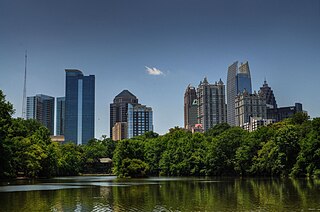
Atlanta is the capital and most populous city of the U.S. state of Georgia. It is the seat of Fulton County, although a portion of the city extends into neighboring DeKalb County. With a population of 498,715 living within the city limits, it is the eighth most populous city in the Southeast and 38th most populous city in the United States according to the 2020 U.S. census. It is the core of the much larger Atlanta metropolitan area, which is home to more than 6.2 million people, making it the eighth-largest U.S. metropolitan area. Situated among the foothills of the Appalachian Mountains at an elevation of just over 1,000 feet (300 m) above sea level, it features unique topography that includes rolling hills, lush greenery, and the densest urban tree coverage of any major city in the United States.
Midtown Atlanta, or Midtown, is a high-density commercial and residential neighborhood of Atlanta, Georgia. The exact geographical extent of the area is ill-defined due to differing definitions used by the city, residents, and local business groups. However, the commercial core of the area is anchored by a series of high-rise office buildings, condominiums, hotels, and high-end retail along Peachtree Street between North Avenue and 17th Street. Midtown, situated between Downtown to the south and Buckhead to the north, is the second-largest business district in Metro Atlanta. In 2011, Midtown had a resident population of 41,681 and a business population of 81,418.

Little Five Points is a district on the east side of Atlanta, Georgia, United States, 2+1⁄2 miles (4.0 km) east of downtown. It was established in the early 20th century as the commercial district for the adjacent Inman Park and Candler Park neighborhoods, and has since become famous for the alternative culture it brings to Atlanta. It has been described as Atlanta's version of Haight-Ashbury, a melting pot of sub-cultures, and the bohemian center of the Southern United States.

Buckhead is the uptown commercial and residential district of the city of Atlanta, Georgia, comprising approximately the northernmost fifth of the city. Buckhead is the third largest business district within the Atlanta city limits, behind Downtown and Midtown, and a major commercial and financial center of the Southeast.
The city of Atlanta, Georgia is made up of 243 neighborhoods officially defined by the city. These neighborhoods are a mix of traditional neighborhoods, subdivisions, or groups of subdivisions. The neighborhoods are grouped by the city planning department into 25 neighborhood planning units (NPUs). These NPUs are "citizen advisory councils that make recommendations to the Mayor and City Council on zoning, land use, and other planning issues". There are a variety of other widely recognized named areas within the city. Some are officially designated, while others are more informal.

Inman Park is an intown neighborhood on the east side of Atlanta, Georgia, and its first planned suburb. It was named for Samuel M. Inman.
East Atlanta is a neighborhood on the east side of Atlanta, Georgia, United States. The name East Atlanta Village primarily refers to the neighborhood's commercial district.

Grant Park refers to the oldest city park in Atlanta, Georgia, United States, as well as the Victorian neighborhood surrounding it.
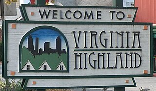
Virginia–Highland is an affluent neighborhood of Atlanta, Georgia, founded in the early 20th century as a streetcar suburb. It is named after the intersection of Virginia Avenue and North Highland Avenue, the heart of its trendy retail district at the center of the neighborhood. The neighborhood is famous for its bungalows and other historic houses from the 1910s to the 1930s. It has become a destination for people across Atlanta with its eclectic mix of restaurants, bars, and shops as well as for the Summerfest festival, annual Tour of Homes and other events.
Mechanicsville is a neighborhood of Atlanta, Georgia. It sits just south of downtown Atlanta.

Brookwood Hills is a historic neighborhood located in intown Atlanta, Georgia, United States, north of Midtown and south-southwest of Buckhead. Home to about 1000 people, it was founded in the early 1920s by Benjamin Franklin Burdett and his son, Arthur. The site of the neighborhood is located where some of the bloodiest battles of the American Civil War took place during the Atlanta Campaign.

The Old Fourth Ward, often abbreviated O4W, is an intown neighborhood on the eastside of Atlanta, Georgia, United States. The neighborhood is best known as the location of the Martin Luther King Jr. historic site.

Westview is a historic intown neighborhood located in southwest Atlanta, Georgia. It is named for the Westview Cemetery that borders the neighborhood to the northwest. The neighborhood is made up of a mixture of architectural styles including Arts & Crafts bungalows, Four-Squares, Tudors, Minimal Traditional houses, and Ranch style houses.
Summerhill is a neighborhood directly south of Downtown Atlanta between the Atlanta Zoo and Center Parc Stadium. It is bordered by the neighborhoods of Grant Park, Mechanicsville, and Peoplestown. Established in 1865, Summerhill is one of Atlanta’s oldest neighborhoods and part of the 26 neighborhoods making up the Atlanta Neighborhood Planning Unit system.
Marietta Street Artery is an officially defined neighborhood of the city of Atlanta, Georgia, part of the West Midtown area of Atlanta, also known as the "Westside."

Chosewood Park is a neighborhood in southeast Atlanta, Georgia in the United States. It is located south of Peoplestown and Grant Park, west of Boulevard Heights and Benteen Park, northwest of Thomasville Heights and the Atlanta federal penitentiary, and northeast of South Atlanta and Lakewood Heights. It is situated directly on the path of the Atlanta Beltline, which has begun to acquire and develop properties along the rail lines in the Chosewood corridor, including the Boulevard Crossing Park.

English Avenue and Vine City are two adjacent and closely linked neighborhoods of Atlanta, Georgia. Together the neighborhoods make up neighborhood planning unit L. The two neighborhoods are frequently cited together in reference to shared problems and to shared redevelopment schemes and revitalization plans.
Atlanta Georgia includes over 3,000 acres of parkland managed by Parks and Recreation. The 343 Atlanta parks range in scope from formal gardens at Atlanta Botanical Garden to pocket parks in neighborhoods. Additionally, there are six miles of paved pedestrian and bike trails in the Atlanta Beltline as well as the PATH Foundation network of 150 miles of off road trails.

Gentrification of Atlanta's inner-city neighborhoods began in the 1970s, and it has continued, at varying levels of intensity, into the present. Many factors have contributed to the city's gentrification. A major increase in gentrification that occurred in the last years of the 20th century has been attributed to the 1996 Summer Olympics. However, during the 2000s, Atlanta underwent a profound transformation demographically, physically, and culturally. Suburbanization, rising prices, a booming economy, and new migrants decreased the city’s black percentage from a high of 67% in 1990 to 54% in 2010. From 2000 to 2010, Atlanta gained 22,763 white residents, 5,142 Asian residents, and 3,095 Hispanic residents, while the city’s black population decreased by 31,678. Much of the city’s demographic change during the decade was driven by young, college-educated professionals: from 2000 to 2009, the three-mile radius surrounding Downtown Atlanta gained 9,722 residents aged 25 to 34 holding at least a four-year degree, an increase of 61%. Between the mid-1990s and 2010, stimulated by funding from the HOPE VI program, Atlanta demolished nearly all of its public housing, a total of 17,000 units and about 10% of all housing units in the city. In 2005, the $2.8 billion BeltLine project was adopted, with the stated goals of converting a disused 22-mile freight railroad loop that surrounds the central city into an art-filled multi-use trail and increasing the city’s park space by 40%. Lastly, Atlanta’s cultural offerings expanded during the 2000s: the High Museum of Art doubled in size; the Alliance Theatre won a Tony Award; and numerous art galleries were established on the once-industrial Westside.

Atlanta's Berlin Wall, also known as the Peyton Road Affair or the Peyton Wall, refers to an event during the civil rights movement in Atlanta, Georgia, United States, in 1962. On December 17 of that year, the government of Atlanta, led by mayor Ivan Allen Jr., erected a barricade in the Cascade Heights neighborhood, mostly along Peyton Road, for the purposes of dissuading African Americans from moving into the neighborhood. The act was criticized by many African American leaders and civil rights groups in the city, and on March 1 of the following year the barricade was ruled unconstitutional and removed. The incident is seen as one of the most public examples of white Americans' fears of racial integration in Atlanta.