Piedmont Park is an urban park in Atlanta, Georgia, located about 1 mile (1.6 km) northeast of Downtown, between the Midtown and Virginia Highland neighborhoods. Originally the land was owned by Dr. Benjamin Walker, who used it as his out-of-town gentleman's farm and residence. He sold the land in 1887 to the Gentlemen's Driving Club, who wanted to establish an exclusive club and racing ground for horse enthusiasts. The Driving Club entered an agreement with the Piedmont Exposition Company, headed by prominent Atlantan Charles A. Collier, to use the land for fairs and expositions and later gave the park its name.
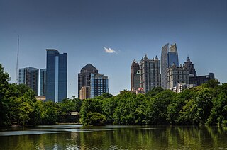
Midtown Atlanta, or Midtown, is a high-density commercial and residential neighborhood of Atlanta, Georgia. The exact geographical extent of the area is ill-defined due to differing definitions used by the city, residents, and local business groups. However, the commercial core of the area is anchored by a series of high-rise office buildings, condominiums, hotels, and high-end retail along Peachtree Street between North Avenue and 17th Street. Midtown, situated between Downtown to the south and Buckhead to the north, is the second-largest business district in Metro Atlanta. In 2011, Midtown had a resident population of 41,681 and a business population of 81,418.

Inman Park is an intown neighborhood on the east side of Atlanta, Georgia, and its first planned suburb. It was named for Samuel M. Inman.

The Margaret Mitchell House is a historic house museum located in Atlanta, Georgia. The structure was the home of author Margaret Mitchell in the early 20th century. It is located in Midtown, at 979 Crescent Avenue. Constructed by Cornelius J. Sheehan as a single-family residence in a then-fashionable section of residential Peachtree Street, the building's original address was 806 Peachtree Street. The house was known as the Crescent Apartments when Mitchell and her husband lived in Apt. 1 on the ground floor from 1925 to 1932. While living there, Mitchell wrote the bulk of her Pulitzer Prize-winning 1936 novel, Gone with the Wind.

Candler Park is a 55-acre city park located at 585 Candler Park Drive NE, in Atlanta, Georgia, United States. It is named after Coca-Cola magnate Asa Griggs Candler, who donated this land to the city in 1922. The park features a nine-hole golf course, a swimming pool, a football/soccer field, a basketball court, tennis courts, and a playground.
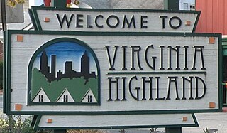
Virginia–Highland is an affluent neighborhood of Atlanta, Georgia, founded in the early 20th century as a streetcar suburb. It is named after the intersection of Virginia Avenue and North Highland Avenue, the heart of its trendy retail district at the center of the neighborhood. The neighborhood is famous for its bungalows and other historic houses from the 1910s to the 1930s. It has become a destination for people across Atlanta with its eclectic mix of restaurants, bars, and shops as well as for the Summerfest festival, annual Tour of Homes and other events.
From its incorporation in 1847, the municipal boundaries of Atlanta, Georgia, United States, were extended repeatedly from a small area around its railroad station to today's city covering 131.7 square miles (341 km2).

Reynoldstown is a historic district and intown neighborhood on the near east side of Atlanta, Georgia, located two miles from downtown. The neighborhood is gentrifying and attracting new families, empty-nesters, Atlantans opposed to long commutes; as well as diverse culture of first-time homebuyers, single professionals, artist and students due to its close proximity to other nearby intown neighborhoods, high walkability index, urban amenities and nearby bohemian hotspots on Carroll Street in the adjoined-at-the-hip also historic Cabbagetown neighborhood and in other surrounding communities.

Clear Creek is a stream in northeast Atlanta that is a tributary to Peachtree Creek and part of the Chattahoochee River watershed. It has two main branches, one originating east of the high ground along which Boulevard runs and another to the west originating on the northeast side of downtown Atlanta. The easterly branch of Clear Creek begins in several springs and branches in what are now Inman Park and the Old Fourth Ward. Flowing north, the creek was joined by other branches and springs, including Angier Springs near the end of Belgrade Avenue and the so-called Ponce de Leon Springs, which were “discovered” during railroad construction in the 1860s and gave rise to the eponymous park and avenue.

Westview is a historic intown neighborhood located in southwest Atlanta, Georgia. It is named for the Westview Cemetery that borders the neighborhood to the northwest. The neighborhood is made up of a mixture of architectural styles including Arts & Crafts bungalows, Four-Squares, Tudors, Minimal Traditional houses, and Ranch style houses.

Ponce de Leon Avenue, often simply called Ponce, provides a link between Atlanta, Decatur, Clarkston, and Stone Mountain, Georgia. It was named for Ponce de Leon Springs, in turn from explorer Juan Ponce de León, but is not pronounced as in Spanish. Several grand and historic buildings are located on the avenue.

Morningside/Lenox Park is an intown neighborhood in Atlanta, Georgia founded in 1923. It is located north of Virginia-Highland, east of Ansley Park and west of Druid Hills. Approximately 3,500 households comprise the neighborhood that includes the original subdivisions of Morningside, Lenox Park, University Park, Noble Park, Johnson Estates and Hylan Park.

Adair Park is a residential neighborhood located southwest of downtown Atlanta. It has the form of a left curly bracket, bordered by the MARTA north–south rail line on the northwest, the BeltLine trail on the southwest and Metropolitan Parkway on the east. Historically Adair Park also included the area from Metropolitan Parkway to McDaniel Street on the east, but the city now considers that area part of the Pittsburgh neighborhood.
Piedmont Heights is an intown neighborhood on the east side of Atlanta, Georgia, founded in the early 20th century as a streetcar suburb. It is located between the BeltLine on the west; across from the Sherwood Forest neighborhood; I-85 on the north, across from an industrial area ; and Piedmont Avenue/Road and Morningside-Lenox Park on the east.

Washington–Rawson was a neighborhood of Atlanta, Georgia. It included what is now Center Parc Stadium and the large parking lot to its north, until 1997 the site of Atlanta–Fulton County Stadium, as well as the I-20-Downtown Connector interchange. Washington and Rawson streets intersected where the interchange is today. To the northwest was Downtown Atlanta, to the west Mechanicsville, to the east Summerhill, and to the south Washington Heights, now called Peoplestown.
Atlanta Georgia includes over 3,000 acres of parkland managed by Parks and Recreation. The 343 Atlanta parks range in scope from formal gardens at Atlanta Botanical Garden to pocket parks in neighborhoods. Additionally, there are six miles of paved pedestrian and bike trails in the Atlanta Beltline as well as the PATH Foundation network of 150 miles of off road trails.
The History of Virginia–Highland, the Intown Atlanta neighborhood, dates back to 1812, when William Zachary bought and built a farm on 202.5 acres (0.819 km2) of land there. At some point between 1888 and 1890 the Nine-Mile Circle streetcar arrived,, making a loop of what are now Ponce de Leon Avenue, North Highland Avenue, Virginia Avenue, and Monroe Drive. Atlantans at first used the line to visit what was then countryside, including Ponce de Leon Springs, but the line also enabled later development in the area. Residential development began as early as 1893 on St. Charles and Greenwood Avenues, must most development took place from 1909 through 1926 — solidly upper-middle class neighborhoods, kept all-white by covenant.
Eastside refers to the city district comprising the easternmost portion of Atlanta, Georgia, United States. The Eastside generally encompasses the area bounded on the west by Midtown Atlanta and Downtown Atlanta and on the east by the city limits. The central corridor of the district is the BeltLine Eastside Trail, which connects northern Eastside neighborhoods with those to the south. The Eastside is known for its nightlife establishments, craftsman architecture, local eateries, and quirky public art.
Piedmont Avenue is a major thoroughfare in Atlanta, beginning in Downtown Atlanta and ending at its continuation as Piedmont Road just before crossing under Interstate 85. Along the way, Piedmont Avenue passes through Midtown Atlanta where several historic properties are located on the street.

Ansley Mall is an open-air shopping mall in the Piedmont Heights neighborhood of Atlanta at 1544 Piedmont Avenue at the intersection of Monroe Drive near the Atlanta BeltLine trail.