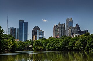
Midtown Atlanta, or Midtown, is a high-density commercial and residential neighborhood of Atlanta, Georgia. The exact geographical extent of the area is ill-defined due to differing definitions used by the city, residents, and local business groups. However, the commercial core of the area is anchored by a series of high-rise office buildings, condominiums, hotels, and high-end retail along Peachtree Street between North Avenue and 17th Street. Midtown, situated between Downtown to the south and Buckhead to the north, is the second-largest business district in Metro Atlanta. In 2011, Midtown had a resident population of 41,681 and a business population of 81,418.

Inman Park is an intown neighborhood on the east side of Atlanta, Georgia, and its first planned suburb. It was named for Samuel M. Inman.
The Atlanta BeltLine is a 22 miles (35 km) open and planned loop of multi-use trail and light rail transit system on a former railway corridor around the core of Atlanta, Georgia. The Atlanta BeltLine is designed to reconnect neighborhoods and communities historically divided and marginalized by infrastructure, improve transportation, add green space, promote redevelopment, create and preserve affordable housing, and showcase arts and culture. The project is in varying stages of development, with several mainline and spur trails complete and others in an unpaved, but hikeable, state. Since the passage of the More MARTA sales tax in 2016, construction of the light rail streetcar system is overseen by MARTA in close partnership with Atlanta BeltLine, Inc.
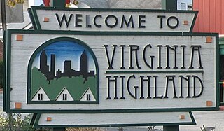
Virginia–Highland is an affluent neighborhood of Atlanta, Georgia, founded in the early 20th century as a streetcar suburb. It is named after the intersection of Virginia Avenue and North Highland Avenue, the heart of its trendy retail district at the center of the neighborhood. The neighborhood is famous for its bungalows and other historic houses from the 1910s to the 1930s. It has become a destination for people across Atlanta with its eclectic mix of restaurants, bars, and shops as well as for the Summerfest festival, annual Tour of Homes and other events.

Cabbagetown is an intown neighborhood on the east side of Atlanta, Georgia, United States, abutting historic Oakland Cemetery. It includes the Cabbagetown District, a historic district listed on the U.S. National Register of Historic Places.

Reynoldstown is a historic district and intown neighborhood on the near east side of Atlanta, Georgia, located two miles from downtown. The neighborhood is gentrifying and attracting new families, empty-nesters, Atlantans opposed to long commutes; as well as diverse culture of first-time homebuyers, single professionals, artist and students due to its close proximity to other nearby intown neighborhoods, high walkability index, urban amenities and nearby bohemian hotspots on Carroll Street in the adjoined-at-the-hip also historic Cabbagetown neighborhood and in other surrounding communities.

Clear Creek is a stream in northeast Atlanta that is a tributary to Peachtree Creek and part of the Chattahoochee River watershed. It has two main branches, one originating east of the high ground along which Boulevard runs and another to the west originating on the northeast side of downtown Atlanta. The easterly branch of Clear Creek begins in several springs and branches in what are now Inman Park and the Old Fourth Ward. Flowing north, the creek was joined by other branches and springs, including Angier Springs near the end of Belgrade Avenue and the so-called Ponce de Leon Springs, which were “discovered” during railroad construction in the 1860s and gave rise to the eponymous park and avenue.

The Old Fourth Ward, often abbreviated O4W, is an intown neighborhood on the eastside of Atlanta, Georgia, United States. The neighborhood is best known as the location of the Martin Luther King Jr. historic site.

Ponce de Leon Avenue, often simply called Ponce, provides a link between Atlanta, Decatur, Clarkston, and Stone Mountain, Georgia. It was named for Ponce de Leon Springs, in turn from explorer Juan Ponce de León, but is not pronounced as in Spanish. Several grand and historic buildings are located on the avenue.

The Ford Motor Company Assembly Plant at 699 Ponce de Leon Avenue in the Poncey-Highland neighborhood of Atlanta, Georgia was the headquarters of the Ford Motor Company's southeastern US operations from 1915 to 1942. As a result of good sales in Atlanta, and a desire to decentralize production, Ford established a combined assembly, sales, service and administration facility on Ponce de Leon Avenue, selling a peak of 22,000 vehicles per year. The assembly plant produced Model Ts, Model As and V-8s until 1942, when the plant was sold to the War Department and a new plant was opened in the Atlanta suburb of Hapeville.

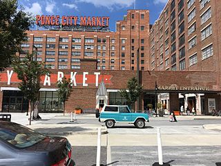
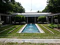
Historic Fourth Ward Park is a park built on the site of the old Ponce de Leon amusement park, in the Old Fourth Ward of Atlanta, just south of Ponce City Market and just west of the BeltLine Eastside Trail.
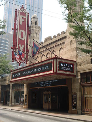
The arts in Atlanta are well-represented, with a prominent presence in music, fine art, and theater.

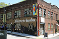
In recent years, Atlanta has become one of the USA's best cities for street art. Street artists have prominently created murals in Krog Street Tunnel, along the BeltLine, and in neighborhoods across the city. The street art conference, Living Walls, the City Speaks, originated in Atlanta in 2009.
The Atlanta neighborhood of Virginia–Highland is one of many intown Atlanta neighborhoods characterized by commercial space of two sorts:

Krog Street Market is a 9-acre (3.6 ha) mixed-use development in Atlanta, located along the BeltLine trail at Edgewood Avenue in Inman Park which opened in Summer 2014. The complex is centered on a 12,000-square-foot (1,100 m2), west coast-style market and restaurants, and also includes up to 300 apartments. The marketplace has been planned to have four or five restaurants and merchants such as florists, cheesemakers, butchers, and bakers under one roof. It is to incorporate two existing parcels on either side of Krog Street: The Stove Works on the west side and the former Tyler Perry Studios at 99 Krog Street, on the east side. The conversion to Krog Street Market is to cost $70 million. The Stove Works is to remain unaltered. Illustrations in the plans show the existing bridge over Krog Street renovated as a pedestrian bridge and incorporated as part of the complex.
Eastside refers to the city district comprising the easternmost portion of Atlanta, Georgia, United States. The Eastside generally encompasses the area bounded on the west by Midtown Atlanta and Downtown Atlanta and on the east by the city limits. The central corridor of the district is the BeltLine Eastside Trail, which connects northern Eastside neighborhoods with those to the south. The Eastside is known for its nightlife establishments, craftsman architecture, local eateries, and quirky public art.
Piedmont Avenue is a major thoroughfare in Atlanta, beginning in Downtown Atlanta and ending at its continuation as Piedmont Road just before crossing under Interstate 85. Along the way, Piedmont Avenue passes through Midtown Atlanta where several historic properties are located on the street.

Edgewood Avenue is a street in Atlanta, Georgia, United States which runs from Five Points in Downtown Atlanta, eastward through the Old Fourth Ward. The avenue runs in the direction of the Edgewood neighborhood, and stops just short of it in Inman Park. Edgewood Avenue was first important as the route of a streetcar line to Inman Park, Atlanta's first garden suburb and home to many of its most prominent citizens. Today, the avenue is known for its restaurants and nightlife around its intersection with Boulevard.

This is the timeline of the development of the BeltLine, a ring of trails and parks around central Atlanta.
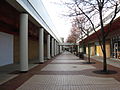
 Interim trail adjacent to Piedmont Park
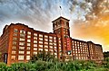 Ponce City Market seen from BeltLine
 Ford Factory Lofts seen from BeltLine, 2012
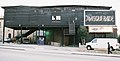


 Inman Park former industrial buildings
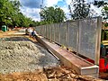 BeltLine Eastside Trail under construction at Irwin Street in the Old Fourth Ward, May 2012.


