Roswell, Georgia | |
---|---|
Location of Roswell in Metro Atlanta | |
Coordinates: 34°02′21″N84°21′05″W / 34.03917°N 84.35139°W | |
Country | United States |
State | Georgia |
County | Fulton |
Incorporated | February 16, 1854 |
Government | |
• Mayor | Kurt Wilson (R) |
• City Administrator | Randy Knighton |
• City Council | Sarah Beeson, Mike Palermo, Christine Hall, Peter Vanstrom, William Morthland, Lee Hills |
Area | |
• Total | 37.00 sq mi (100.77 km2) |
• Land | 36.73 sq mi (99.48 km2) |
• Water | 1.27 sq mi (3.29 km2) 3.1% |
Elevation | 1,050 ft (320 m) |
Population (2020) | |
• Total | 92,833 |
• Density | 2,279.40/sq mi (880.08/km2) |
Time zone | UTC−5 (EST) |
• Summer (DST) | UTC−4 (EDT) |
ZIP codes | 30075-30077 |
Area code | 770/678/404 |
FIPS code | 13-67284 [3] |
GNIS feature ID | 2404651 [2] |
Website | www |
Roswell is a city in northern Fulton County, Georgia, United States. At the official 2020 census, the city had a population of 92,883, making Roswell the state's ninth largest city. [4] A close suburb of Atlanta, Roswell has an affluent historic district. [5]
In 1830, while on a trip to northern Georgia, Roswell King passed through the area of what is now Roswell and observed the great potential for building a cotton mill along Vickery Creek. Since the land nearby was also good for plantations, he planned to put cotton processing near cotton production.
Toward the middle of the 1830s, King returned to build a mill that would soon become the largest in north Georgia – Roswell Mill. He brought with him 36 African slaves from his own coastal plantation, plus another 42 skilled carpenter slaves bought in Savannah to build the mills. The slaves built the mills, infrastructure, houses, mill worker apartments, and supporting buildings for the new town. The Africans brought their unique Geechee culture, language, and religious traditions from the coast to north Georgia.
King invited investors from the coast to join him at the new location. He was also joined by Barrington King, one of his sons, who succeeded his father in the manufacturing company. Archibald Smith was one of the planters who migrated there to establish a new plantation, also bringing enslaved African Americans from the coastal areas.
Shortly after 1832 a survey of the area was conducted by Nathan Crawford Barnett as part of the Cherokee Purchase in preparation for the sixth state administrated land lottery culminating in the Cherokee removal. [6] [7]
Barrington Hall (the home of Barrington King), Smith Plantation (the home of Archibald Smith) and Bulloch Hall (the childhood home of President Theodore Roosevelt's mother, Mittie Bulloch) have been preserved and restored. They are now open to the public. According to the 1850 Slave Schedules, these three "founding families", together with the next three largest planters, held 192 slaves, 51% of the total 378 slaves held in Roswell District. Archibald Smith had a 300-acre (1.2 km2) cotton plantation. According to the 1850 Census, Barrington King held 70 slaves. Half of these slaves were under the age of 10. These slaves worked in Barrington's household. Barrington King "leased" or "rented" some of his adult male slaves to the Roswell Manufacturing Company, but they did not work around the mill machinery.
The Roswell area was part of Cobb County when first settled, and the county seat of Marietta was a four-hour (one-way) horseback ride to the west. Since Roswell residents desired a local government, they submitted a city charter for incorporation to the Georgia General Assembly. The charter was approved on February 16, 1854.
By the time of the Civil War, the cotton mills employed more than 400 people, mostly women. Given settlement patterns in the Piedmont region, they were likely of Scots-Irish descent. As the mill increased in production, so did the number of people living in the area.
During the Civil War, the city was captured by Union forces under the leadership of General Kenner Garrard. Under orders of General Sherman, Garrard shipped the mill workers north to prevent them from returning to work if the mills were rebuilt. This was a common tactic of Sherman to economically disrupt the Confederate rebellion. The mill was burned, but the houses were left standing. The ruins of the mill and the 30-foot (9.1 m) dam that was built for power still remain. Most of the town's property was confiscated by Union forces. The leading families had left the town to go to safer places well before the Civil War, and arranged for the enslaved people to be taken away from advancing Union troops, as was often the practice. Some slaves may have escaped to freedom beyond Union lines.
After the war, Barrington King rebuilt the mills and resumed production. While many freedmen stayed in the area to work as paid labor on plantations or in town, others migrated to Fulton County and Atlanta for new opportunities. The South suffered an agricultural depression resulting from the effects of the war and the end of slavery in the United States.
According to the census, the population of Cobb County decreased slightly from 14,242 in 1860, to 13,814 in 1870. The proportion of African-Americans decreased more, from 27% to 23%. During those years, nearby Fulton County more than doubled in population, from 14,427 to 33,336. The effects of dramatic African-American migration can be seen by the increase in Fulton County from 20.5% slave in 1860 to 45.7% colored (Black) in 1870.
At the end of 1931, the United States was in the midst of the Great Depression. The difficult economic conditions drove Milton County, Roswell's neighboring county to the north (note: much of what is now Roswell was part of Milton County already), to merge in its entirety with Fulton County, Roswell's neighboring county to the south. To facilitate the merger, Roswell was ceded from Cobb County to become part of Fulton County. This became effective the 9th day of May in 1932. Roswell filed all legal records, including vital statistics, real estate, and the results of torts with the county clerk of Cobb before this date; with the county clerk of Fulton, after this date.
Lori Henry served as the first woman elected as Mayor of Roswell from 2018 to 2021.
Kurt Wilson is the current Mayor of Roswell. His term began in January 2022 and ends December 31, 2025.
Roswell is located in northern Fulton County. It is bordered to the north by Milton, to the northeast by Alpharetta, to the east by Johns Creek, to the southeast by Peachtree Corners in Gwinnett County, to the south by Sandy Springs, to the west by unincorporated land in Cobb County, and to the northwest by the city of Mountain Park and by unincorporated land in Cherokee County. The southern boundary of the city follows the Chattahoochee River.
According to the United States Census Bureau, Roswell has a total area of 37.0 square miles (100.8 km2), of which 40.7 square miles (105.5 km2) is land and 1.3 square miles (3.3 km2), or 3.06%, is water. [5]
Roswell features a Humid subtropical climate, which is characterized by abundant precipitation that is spread evenly throughout the year.
Climate data for Roswell, Georgia | |||||||||||||
---|---|---|---|---|---|---|---|---|---|---|---|---|---|
Month | Jan | Feb | Mar | Apr | May | Jun | Jul | Aug | Sep | Oct | Nov | Dec | Year |
Mean daily maximum °F (°C) | 49.2 (9.6) | 53.4 (11.9) | 62.4 (16.9) | 71.5 (21.9) | 78.4 (25.8) | 84.9 (29.4) | 87.4 (30.8) | 86.9 (30.5) | 81.3 (27.4) | 71.7 (22.1) | 62.3 (16.8) | 52.7 (11.5) | 70.2 (21.2) |
Mean daily minimum °F (°C) | 27.9 (−2.3) | 29.9 (−1.2) | 37.0 (2.8) | 44.7 (7.1) | 53.9 (12.2) | 61.9 (16.6) | 65.6 (18.7) | 65.2 (18.4) | 59.3 (15.2) | 46.7 (8.2) | 37.5 (3.1) | 30.7 (−0.7) | 46.7 (8.2) |
Average rainfall inches (mm) | 4.9 (120) | 4.9 (120) | 6.0 (150) | 4.2 (110) | 4.3 (110) | 3.8 (97) | 4.5 (110) | 4.0 (100) | 3.8 (97) | 3.6 (91) | 3.7 (94) | 4.7 (120) | 52.3 (1,330) |
Source: [8] |
Census | Pop. | Note | %± |
---|---|---|---|
1870 | 479 | — | |
1880 | 1,180 | 146.3% | |
1890 | 1,138 | −3.6% | |
1900 | 1,329 | 16.8% | |
1910 | 1,158 | −12.9% | |
1920 | 1,227 | 6.0% | |
1930 | 1,432 | 16.7% | |
1940 | 1,622 | 13.3% | |
1950 | 2,123 | 30.9% | |
1960 | 2,983 | 40.5% | |
1970 | 5,430 | 82.0% | |
1980 | 23,337 | 329.8% | |
1990 | 47,923 | 105.4% | |
2000 | 79,334 | 65.5% | |
2010 | 88,346 | 11.4% | |
2020 | 92,833 | 5.1% | |
U.S. Decennial Census [9] |
Race | Num. | Perc. |
---|---|---|
White (non-Hispanic) | 58,745 | 63.28% |
Black or African American (non-Hispanic) | 10,694 | 11.52% |
Native American | 87 | 0.09% |
Asian | 4,626 | 4.98% |
Pacific Islander | 31 | 0.03% |
Other/Mixed | 4,560 | 4.91% |
Hispanic or Latino | 14,090 | 15.18% |
As of the 2020 United States census, there were 92,833 people, 35,944 households, and 25,529 families residing in the city.
In the last official U.S. Census of 2010, Roswell had a population of 88,346. The racial and ethnic composition of the population was 74.7% White, 11.7% Black or African American, 4.0% Asian, 0.3% Native American, 0.1% Pacific Islander, 6.6% from some other race and 2.5% from two or more races. 16.6% of the population was Hispanic or Latino of any race; a majority of them were of Mexican origin (11.5% of the total population). [11]
In the preceding census [3] of 2000, there were 79,334 people, 30,207 households, and 20,933 families residing in the city. The population density was 2,086.5 inhabitants per square mile (805.6/km2). There were 31,300 housing units at an average density of 823.2 per square mile (317.8/km2). The racial makeup of the city was 81.51% White, 8.54% African American, 0.20% Native American, 3.74% Asian, 0.03% Pacific Islander, 4.08% from other races, and 1.90% from two or more races. Hispanic or Latino of any race were 10.61% of the population.
There were 30,207 households, out of which 34.6% had children under the age of 18 living with them, 57.1% were married couples living together, 8.6% had a female householder with no husband present, and 30.7% were non-families. 23.1% of all households were made up of individuals, and 4.5% had someone living alone who was 65 years of age or older. The average household size was 2.61 and the average family size was 3.07.
In the city, the population was spread out, with 24.4% under the age of 18, 8.2% from 18 to 24, 35.1% from 25 to 44, 24.7% from 45 to 64, and 7.5% who were 65 years of age or older. The median age was 37.2 years. For every 100 females, there were 100.0 males. For every 100 females age 18 and over, there were 98.0 males.
According to a 2007 estimate, the median income for a household in the city was $73,469, and the median income for a family was $103,698. The average income for households was $106,219 and the average income for families was $123,481. Males had a median income of $72,754 versus $45,979 for females. The per capita income for the city was $40,106. About 3.2% of families and 5.0% of the population were below the poverty line, including 5.6% of those under age 18 and 0.7% of those age 65 or over. [12]
Household income (2010) [13]
Income | Percent |
---|---|
under $14,999 | 3.8% |
$15,000 – $34,999 | 3.7% |
$35,000 – $74,999 | 14.4% |
$75,000 – $99,999 | 17.9% |
$100,000 – $149,999 | 24.3% |
$150,000 – $199,999 | 6.9% |
$200,000 + | 11.0% |
Household income (2010) [13]
Median | $87,080 |
Per capita | $43,286 |
Mean | $117,088 |
Average family size | 3.23 |
Average household size | 2.70 |
Roswell median housing value [13]
Year | Value |
---|---|
1990 | $143,497 |
2000 | $207,700 |
2005 | $299,000 |
2000 population by age [13]
Age | Percent |
---|---|
Under 5 | 6.8% |
5–9 | 7.9% |
10–19 | 12.7% |
20–29 | 9.8% |
30–39 | 19.4% |
40–49 | 17.2% |
50–59 | 13.9% |
60–69 | 5.5% |
70 and over | 4.4% |
Not known | 2.4% |
Median age | 37.2 |
Population by gender (2006) [13]
Gender | Percent |
---|---|
Male | 49.2% |
Female | 50.8% |
Education [13]
Level | Percent |
---|---|
Less than high school | 5.1% |
High school graduate | 12.8% |
Associate degree | 6.1% |
Bachelor's degree | 40.3% |
Graduate degree | 18.8% |
Race and ethnicity [13]
Ethnicity | Percent |
---|---|
American Indian, Eskimo, Aleut | 0.9% |
Asian | 4.4% |
Black | 12.4% |
White | 73.9% |
Other | 6.3% |
Hispanic | 14.8% |
The Consulate-General of Honduras in Atlanta is located at Suite 3 in 600 Houze Way in Roswell. [14] The city's largest employers are The Kimberly Clark Corporation, Wellstar North Fulton Hospital, Harry's Farmers Market, and The City Of Roswell. [15] A section of Route 400 between Roswell and Atlanta is known as the high tech corridor, where many technology firms like Kimberly Clark have factories or offices. [16] As of the 2006 census, one third of Roswell's 5.000 registered business were home based. The largest industries were retail, technology, food services, wholesale trade and health care. [16]
Many Roswell residents work in nearby Atlanta. [16]
Businesses with their headquarters in Roswell include Snorg Tees, [17] Tripwire Interactive, [18] and Pharsalia Technologies. [19]
Atlanta-Fulton Public Library System operates the Roswell Branch and the East Roswell Branch. [21]
The Chess Club and Scholastic Center of Atlanta, founded by GM Ben Finegold, is located in Roswell.
The city maintains more than 900 acres (3.6 km2) of parkland, as well as three historic house museums.
A branch of the Chattahoochee River National Recreation Area, a component of the National Park System, is located in Roswell at Vickery Creek.
Roswell's local public schools are part of the Fulton County School System.
Fulton County is a county in the north-central portion of the U.S. state of Georgia. As of the 2020 United States census, the population was 1,066,710, making it the state's most populous county and its only one with over one million inhabitants. Its county seat and most populous city is Atlanta, the state capital. About 90% of the City of Atlanta is within Fulton County; the remaining portion is in DeKalb County. Fulton County is part of the Atlanta–Sandy Springs–Roswell, GA Metropolitan Statistical Area.
Forsyth County is a county in the Northeast portion of the U.S. state of Georgia. Suburban and exurban in character, Forsyth County lies within the Atlanta Metropolitan Area. The county's only incorporated city and county seat is Cumming. At the 2020 census, the population was 251,283. Forsyth was the fastest-growing county in Georgia and the 15th fastest-growing county in the United States between 2010 and 2019.
Douglas County is a county located in the north central portion of the U.S. state of Georgia. As of the 2020 U.S. Census, the population was 144,237, having more than doubled since 1990. The county seat is Douglasville. The City of Villa Rica, and a small portion of Austell are both also located in Douglas County. Douglas County is included in the Atlanta-Sandy Springs-Roswell, GA Metropolitan Statistical Area. It has attracted new residents as jobs have increased in the Atlanta area.
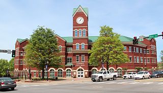
Cobb County is a county in the U.S. state of Georgia, located in the Atlanta metropolitan area in the north central portion of the state. As of 2020 Census, the population was 766,149. It is the state's third most populous county, after Fulton and Gwinnett counties. Its county seat is Marietta; its largest city is Mableton.
Carroll County is a county located in the northwestern part of the State of Georgia. As of the 2020 census, its population was 119,148. Its county seat is the city of Carrollton. Carroll County is included in the Atlanta-Sandy Springs-Roswell metropolitan statistical area and is also adjacent to Alabama on its western border.
Canton is a city in and the county seat of Cherokee County, Georgia, United States. As of the 2010 census, the city had a population of 22,958, up from 7,709 in 2000.
Austell is a city in Cobb and Douglas counties in the U.S. state of Georgia. It is part of the Atlanta metropolitan area. As of the 2020 census, the city had a population of 7,713.
Mableton is a city in Cobb County, Georgia, United States. Voters of the unincorporated area of Mableton approved a referendum to incorporate on November 8, 2022, and six council members were elected on March 21, 2023, with Michael Owens elected as mayor of Mableton in the 2023 Mableton mayoral election. According to the 2020 census, the census-designated area Mableton had a population of 37,115; the city has more. Upon Brookhaven's cityhood in December 2012, Mableton was previously the largest unincorporated CDP in Metro Atlanta. With boundaries described in Appendix A of House Bill 839, Mableton is the largest city in Cobb County in terms of population and includes historical Mableton, along with the Six Flags area, areas of unincorporated Smyrna, and parts of unincorporated South Cobb.
Vinings is an unincorporated community and census-designated place (CDP) in Cobb County, Georgia, United States that runs along the Chattahoochee River bank across from Buckhead. As of the 2020 census, the CDP had a total population of 12,581. Located next to the affluent Paces section of Buckhead in northwest Atlanta, Vinings is known for its historic sites, shopping districts, proximity to local freeways and The Battery, and nearby nature areas. The United States Postal Service assigns "Atlanta" to the ZIP Code (30339) that includes Vinings.
Cumming is a city in Forsyth County, Georgia, United States, and the sole incorporated area in the county. It is a suburban city, and part of the Atlanta metropolitan area. In the 2020 census, the population is 7,318, up from 5,430 in 2010. Surrounding unincorporated areas with a Cumming mailing address have a population of approximately 100,000. Cumming is the county seat of Forsyth County.
Alpharetta is a city in northern Fulton County, Georgia, United States, and part of the Atlanta metropolitan area. As of the 2020 US Census, Alpharetta's population was 65,818; in 2010, the population was 57,551.
Sandy Springs is a city in northern Fulton County, Georgia, United States, and a suburb of Atlanta. The city's population was 108,080 at the 2020 census, making it Georgia's 7th most populous city. It is the site of several corporate headquarters, including UPS, Newell Brands, Inspire Brands, Focus Brands, Cox Enterprises, and Mercedes-Benz USA's corporate offices.
Duluth is a city in Gwinnett County, Georgia, United States. Located north of Interstate 85, it is approximately 22 miles (35 km) northeast of Atlanta.
The Chattahoochee River forms the southern half of the Alabama and Georgia border, as well as a portion of the Florida and Georgia border. It is a tributary of the Apalachicola River, a relatively short river formed by the confluence of the Chattahoochee and Flint rivers and emptying from Florida into Apalachicola Bay in the Gulf of Mexico. The Chattahoochee River is about 430 miles (690 km) long. The Chattahoochee, Flint, and Apalachicola rivers together make up the Apalachicola–Chattahoochee–Flint River Basin. The Chattahoochee makes up the largest part of the ACF's drainage basin.
There were several historic mills around the metro Atlanta area, for which many of its current-day roads are still named. Most of the mills date back to the 1820s and 1830s, and were built along the area's many streams. The locations of many of these mills are shown on a map of 1875 showing U. S. military operations around Atlanta in 1864. This map is now located in the U. S. Library of Congress but can be seen on the webpage linked here.
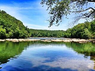
Chattahoochee River National Recreation Area (CRNRA) preserves a series of sites between Atlanta and Lake Sidney Lanier along the Chattahoochee River in Georgia, U.S. The 48-mile (77 km) stretch of the river affords public recreation opportunities and access to historic sites. The national recreation area, a National Park Service unit, was established on August 15, 1978, by President Jimmy Carter.
Milton is a city in Fulton County, Georgia, United States. Located about 30 miles due north of Atlanta, Milton is known for its rural and equestrian heritage. The City was incorporated on December 1, 2006, out of the unincorporated northernmost part of northern Fulton County. As of the 2010 census, Milton's population was 32,661, with an estimated population of 39,587 in 2019. Milton is named in honor of the former Milton County, which was named after Revolutionary War hero John Milton. The portion of north Fulton County generally north of the Chattahoochee River comprises most of the territory of the former Milton County.
Johns Creek is a city in Fulton County, Georgia, United States. According to the 2020 census, the population was 82,453. The city is a northeastern suburb of Atlanta.
Roswell King was an American businessman, planter, slave owner, and industrialist. Together with his son, Barrington King, he founded Roswell Manufacturing Company in the Georgia Piedmont, establishing a cotton mill and industrial complex. They co-founded the town of Roswell, Georgia, inviting friends to be part of its and the mill's development in the 1830s. Roswell's family originally hailed from Delaware but later moved to Connecticut where they were among the first residents of New Haven and later Windsor. As a teen, Roswell participated in the American Revolutionary War as part of the naval resistance before moving to Georgia's low country.
Roswell Mill refers to a cluster of mills located in Fulton County near Vickery Creek in Roswell, Georgia. The mills were best known for producing finished textiles from raw materials grown on nearby plantations, and the group was "the largest cotton mill in north Georgia" at its height.