History
The area that now encompasses the Perkerson neighborhood was originally owned by Jeremiah S. Gilbert (a farmer), who purchased the land from his father, the first doctor in Fulton County. Gilbert was married to Mathilda Perkerson, the daughter of Thomas Jefferson Perkerson, who was the second sheriff of Fulton County, who originated from another pioneer family of Fulton County. The Perkerson neighbourhood developed on the land of Thomas J. Perkerson and Jeremiah S. Gilbert. They purchased 500 acres (2.0 km2) from his father's holdings. The land was not developed fully until the 1950s.
Thomas J. Perkerson settled in Land Lots 103 and 104 (Perkerson Park and Sylvan Hills) with his family in the mid-1830s. His home stood for over a hundred years on Perkerson Road (Old Rough and Ready Road) before its demolition for construction of a grocery store.
Thomas Perkerson was the second sheriff of Fulton County. His land was subdivided into Perkerson Park and Sylvan Hills in 1944 after the death of Lizzie Perkerson Butler, who was the last family member to live in their house, which had survived General Sherman's burning of Atlanta. The family refused to leave the house as Matilda Perkerson Gilbert was too sick to be moved.
Plunkett Town was located at the southern edge of what is now Perkerson, around the current location of the I-75 Cleveland Avenue interchange.e.
Fulton County is a county in the north-central portion of the U.S. state of Georgia. As of the 2020 United States census, the population was 1,066,710, making it the state's most populous county and its only one with over one million inhabitants. Its county seat and most populous city is Atlanta, the state capital. About 90% of the City of Atlanta is within Fulton County; the remaining portion is in DeKalb County. Fulton County is part of the Atlanta–Sandy Springs–Roswell, GA Metropolitan Statistical Area.

DeKalb County is located in the north central portion of the U.S. state of Georgia. As of the 2020 census, the population was 764,382, making it Georgia's fourth-most populous county. Its county seat is Decatur.

North Druid Hills, also known as Briarcliff or Toco Hills, is an unincorporated community and census-designated place in DeKalb County, Georgia, United States. The population was 18,947 at the 2010 census. The commercial center of the area is the Toco Hill Shopping Center, located near the intersection of North Druid Hills Road and LaVista Road.

Duluth is a city in Gwinnett County, Georgia, United States. Located north of Interstate 85, it is approximately 22 miles (35 km) northeast of Atlanta.
The city of Atlanta, Georgia is made up of 243 neighborhoods officially defined by the city. These neighborhoods are a mix of traditional neighborhoods, subdivisions, or groups of subdivisions. The neighborhoods are grouped by the city planning department into 25 neighborhood planning units (NPUs). These NPUs are "citizen advisory councils that make recommendations to the Mayor and City Council on zoning, land use, and other planning issues". There are a variety of other widely recognized named areas within the city. Some are officially designated, while others are more informal.
East Atlanta is a neighborhood on the east side of Atlanta, Georgia, United States. The name East Atlanta Village primarily refers to the neighborhood's commercial district.

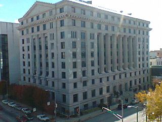
The Atlanta–Fulton Public Library System is a network of public libraries serving the City of Atlanta and Fulton County, both in the U.S. state of Georgia. The system is administered by Fulton County. The system is composed of the Atlanta Central Library in Downtown Atlanta, which serves as the library headquarters, as well as the Auburn Avenue Research Library on African American Culture and History, and 33 branch libraries.

State Route 42 (SR 42) is a 115.3-mile-long (185.6 km) state highway that runs southeast-to-northwest through portions of Peach, Crawford, Monroe, Butts, Henry, Clayton, and DeKalb counties in the central and north-central parts of the U.S. state of Georgia. The route connects Byron with the Atlanta metropolitan area, via Forsyth, McDonough, and Forest Park.

The Fulton County School System is a school district headquartered in Sandy Springs, Georgia, United States. The system serves the area of Fulton County outside the Atlanta city limits. Fulton County Schools serve the cities of Alpharetta, Johns Creek, Milton, Mountain Park, Roswell, and Sandy Springs north of Atlanta, and Chattahoochee Hills, College Park, East Point, Fairburn, Hapeville, Palmetto, Union City, South Fulton, and Fulton's remaining unincorporated areas in the south. Fulton County is the fourth-largest school system in Georgia.

Atlanta Public Schools (APS) is a school district based in Atlanta, Georgia, United States. It is run by the Atlanta Board of Education with Interim Superintendent Dr. Danielle S. Battle. The system has an active enrollment of 54,956 students, attending a total of 103 school sites: 50 elementary schools, 15 middle schools, 21 high schools, four single-gender academies and 13 charter schools. The school system also supports two alternative schools for middle and/or high school students, two community schools, and an adult learning center.

Oakland City is a rail station in Atlanta, Georgia, serving the Red and Gold lines of the Metropolitan Atlanta Rapid Transit Authority (MARTA) rail system. Opened on December 15, 1984, it has one island platform between two tracks. Both sides of the station are accessed via a pedestrian underpass beneath adjacent roadways and, in the case of the east underpass, a freight railway. Though at-grade, the steep embankment on which this station is situated gives it the appearance of an elevated station. This station mainly serves the Oakland City, Sylvan Hills and Capitol View neighborhoods of Atlanta.

East Point is a train station in East Point, Georgia, serving the Red and Gold lines of the Metropolitan Atlanta Rapid Transit Authority (MARTA) rail system. It has an island platform between two tracks. It was opened on August 16, 1986.

Sylvan Hills is a historic intown neighborhood in southwest Atlanta, Georgia, United States.

Capitol View Manor is a small community in Southwest Atlanta that was named for the excellent view of the Georgia State Capitol building. Its boundaries include I-75/85 to the east, the Beltline to the north, Metropolitan Parkway to the west, and Atlanta Technical College to the south.

Perkerson Park is a 50-acre (200,000 m2) park in the Capitol View and Sylvan Hills neighborhoods of Atlanta, Georgia with many offerings such as disc golf, tennis courts, splash pads, an elaborate playground, recreational fields, all under the shady canopy of huge oak trees. The park is open 6:00 AM to 11:00 PM daily.

Ponce de Leon Avenue, often simply called Ponce, provides a link between Atlanta, Decatur, Clarkston, and Stone Mountain, Georgia. It was named for Ponce de Leon Springs, in turn from explorer Juan Ponce de León, but is not pronounced as in Spanish. Several grand and historic buildings are located on the avenue.

Capitol View is a historic intown southwest Atlanta, Georgia neighborhood. The neighborhood is 2.5 miles from downtown and was named for its views of the Georgia State Capitol building. Its boundaries include Metropolitan Parkway to the east, Lee Street to the west, and the Beltline to the north. On the south, the border follows Arden Street, Deckner Avenue, and Perkerson Park.
Atlanta Georgia includes over 3,000 acres of parkland managed by Parks and Recreation. The 343 Atlanta parks range in scope from formal gardens at Atlanta Botanical Garden to pocket parks in neighborhoods. Additionally, there are six miles of paved pedestrian and bike trails in the Atlanta Beltline as well as the PATH Foundation network of 150 miles of off road trails.
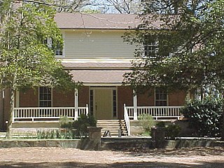
The Jeremiah S. Gilbert House is a NRHP-listed property in the neighborhood of Perkerson, Atlanta, United States. It is one of the city's oldest surviving structures.