This article needs additional citations for verification .(May 2019) |


Five Points is a district of Atlanta, Georgia, United States, the primary reference for the downtown area.
This article needs additional citations for verification .(May 2019) |
Five Points is a district of Atlanta, Georgia, United States, the primary reference for the downtown area.
The name refers to the convergence of Marietta Street, Edgewood Avenue, Decatur Street, and two legs of Peachtree Street (the south-southwestern leg was originally Whitehall Street, before a section of Whitehall was renamed as an extension of Peachtree Street to give businesses south of Five Points the prestige of a Peachtree Street address). Five Points is usually considered by Atlantans to be the center of town, and it is the origin of the street addressing system for the city and county, although four of the streets (except Edgewood) are rotated at least 30° clockwise from their nominal directions, along with the rest of the downtown street grid. [1]
Woodruff Park is on the northeast corner of the intersection, between Peachtree Street and Edgewood Avenue. The Five Points MARTA station is one block south of the intersection on Peachtree Street.
A large round Coca-Cola sign overlooks Five Points, atop the Olympia Building on the east side of the intersection between Edgewood Avenue and Decatur Avenue. The nearly 50-foot tall sign has a 33-foot lighted neon face and faces up and down Peachtree Street. A lighted portion at the bottom of the sign gives the current time and temperature. [2]
At the other corners of Five Points are located: Woodruff Park (northeast); the William-Oliver Building (northwest); Georgia State University's Andrew Young School of Policy Studies (southwest); and a parking garage (southeast). On a triangular island in the intersection stands the George Beasley sculpture Five Points Monument, alluding to the water tower formerly standing on the spot as well as the streetcar tracks that once existed in the intersection.
Prior to the arrival of white settlers, Five Points was the intersection of two Creek Indian trails, the Peachtree Trail and the Sandtown Trail. In 1845, George Washington Collier opened a grocery store at what is now Five Points, and the store later served as Atlanta's first post office in 1846. In 1848, Five Points served as the location of Atlanta's first mayoral election. Moses Formwalt became Atlanta's first mayor, defeating Jonathan Norcross. In 1875, Atlanta's drinking water system began with the construction of three artesian wells at Five Points. The system delivered water to Atlanta's residents via wooden pipes.
Until the 1960s, Five Points represented the central hub of Atlanta. With the advent of urban sprawl and the development of shopping malls, the economic and demographic center of Atlanta shifted northward, and Five Points went into decay. By the 21st century, the area was revitalizing, mostly due to the expansion of Georgia State University, which maintains a large footprint in Five Points.

The history of Atlanta dates back to 1836, when Georgia decided to build a railroad to the U.S. Midwest and a location was chosen to be the line's terminus. The stake marking the founding of "Terminus" was driven into the ground in 1837. In 1839, homes and a store were built there and the settlement grew. Between 1845 and 1854, rail lines arrived from four different directions, and the rapidly growing town quickly became the rail hub for the entire Southern United States. During the American Civil War, Atlanta, as a distribution hub, became the target of a major Union campaign, and in 1864, Union William Sherman's troops set on fire and destroyed the city's assets and buildings, save churches and hospitals. After the war, the population grew rapidly, as did manufacturing, while the city retained its role as a rail hub. Coca-Cola was launched here in 1886 and grew into an Atlanta-based world empire. Electric streetcars arrived in 1889, and the city added new "streetcar suburbs".
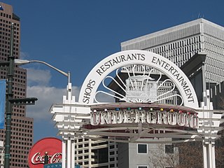
Underground Atlanta is a shopping and entertainment district in the Five Points neighborhood of downtown Atlanta, Georgia, United States, near the Five Points MARTA station. It is currently undergoing renovations. First opened in 1969, it takes advantage of the viaducts built over the city's many railroad tracks to accommodate later automobile traffic.
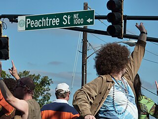
Peachtree Street is one of several major streets running through the city of Atlanta, Georgia, United States. Beginning at Five Points in downtown Atlanta, it runs North through Midtown; a few blocks after entering into Buckhead, the name changes to Peachtree Road at Deering Road. Much of the city's historic and noteworthy architecture is located along the street, and it is often used for annual parades,, as well as one-time parades celebrating events such as the 100th anniversary of Coca-Cola in 1986 and the Atlanta Braves' 1995 and 2021 World Series victories.
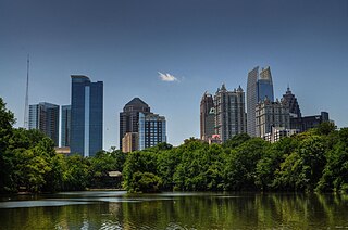
Midtown Atlanta, or Midtown, is a high-density commercial and residential neighborhood of Atlanta, Georgia. The exact geographical extent of the area is ill-defined due to differing definitions used by the city, residents, and local business groups. However, the commercial core of the area is anchored by a series of high-rise office buildings, condominiums, hotels, and high-end retail along Peachtree Street between North Avenue and 17th Street. Midtown, situated between Downtown to the south and Buckhead to the north, is the second-largest business district in Metro Atlanta. In 2011, Midtown had a resident population of 41,681 and a business population of 81,418.

Little Five Points is a district on the east side of Atlanta, Georgia, United States, 2+1⁄2 miles (4.0 km) east of downtown. It was established in the early 20th century as the commercial district for the adjacent Inman Park and Candler Park neighborhoods, and has since become famous for the alternative culture it brings to Atlanta. It has been described as Atlanta's version of Haight-Ashbury, a melting pot of sub-cultures, and the bohemian center of the Southern United States.
Standing Peachtree was a Muscogee village and the closest Indian settlement to what is now the Buckhead area of Atlanta, Georgia. It was located where Peachtree Creek flows into the Chattahoochee River, in today's Paces neighborhood. It was located in the borderlands of the Cherokee and Muscogee nations. It is referred to in several documents dating as far back as 1782.

Downtown Atlanta is the central business district of Atlanta, Georgia, United States. The largest of the city's three commercial districts, it is the location of many corporate and regional headquarters; city, county, state, and federal government facilities; Georgia State University; sporting venues; and most of Atlanta's tourist attractions. It measures approximately four square miles, and had 26.850 residents as of 2017. Similar to other central business districts in the United States, it has recently undergone a transformation that includes the construction of new condos and lofts, renovation of historic buildings, and arrival of new residents and businesses.
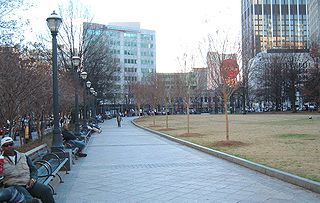
Woodruff Park, named for Robert W. Woodruff, is located in the heart of Downtown Atlanta, Georgia. The park's 6 acres (2.4 ha) are north of Edgewood Ave, between Peachtree Street NE and Park Place NE. The park includes a fountain, a performance pavilion, and several monuments.

Peachtree Center is an underground train station on the Red and Gold lines of the Metropolitan Atlanta Rapid Transit Authority (MARTA) rail system. It is the deepest station in the MARTA rail system, at 120 feet (37 m) below Peachtree Street. It serves the Peachtree Center neighborhood of downtown Atlanta, and is the first station north-northeast of the rail system hub at Five Points. Peachtree Center is one of the busiest stations on the Red/Gold Lines, handling over 15,000 people per weekday.

Clear Creek is a stream in northeast Atlanta that is a tributary to Peachtree Creek and part of the Chattahoochee River watershed. It has two main branches, one originating east of the high ground along which Boulevard runs and another to the west originating on the northeast side of downtown Atlanta. The easterly branch of Clear Creek begins in several springs and branches in what are now Inman Park and the Old Fourth Ward. Flowing north, the creek was joined by other branches and springs, including Angier Springs near the end of Belgrade Avenue and the so-called Ponce de Leon Springs, which were “discovered” during railroad construction in the 1860s and gave rise to the eponymous park and avenue.

Ponce de Leon Avenue, often simply called Ponce, provides a link between Atlanta, Decatur, Clarkston, and Stone Mountain, Georgia. It was named for Ponce de Leon Springs, in turn from explorer Juan Ponce de León, but is not pronounced as in Spanish. Several grand and historic buildings are located on the avenue.

North Avenue is a major avenue in Atlanta, Georgia that divides Downtown Atlanta from Midtown Atlanta. North Avenue stretches continuously in Atlanta from Candler Park in the east, across Interstate 75 & Interstate 85, along the southern boundary of the Georgia Institute of Technology, to Joseph E. Lowery Boulevard just southwest of Georgia Tech, where it ends. North Avenue passes through the neighborhoods of Poncey-Highland, Old Fourth Ward, and Midtown Atlanta.

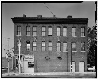
The Dixie Coca-Cola Bottling Company Plant, also known as Baptist Student Center, or Baptist Collegiate Ministry at Georgia State University, is a historic building at 125 Edgewood Avenue in Atlanta, Georgia. Built in 1891, it was the headquarters and bottling plant of the Dixie Coca-Cola Bottling Company, and the place where the transition from Coca-Cola as a drink served at a soda fountain to a mass-marketed bottled soft drink took place. It was declared a National Historic Landmark in 1983, and is one of the only buildings in Atlanta dating to Coca-Cola's early history. Since 1966 the building has been the Baptist Student Ministry location for Georgia State University.

The Hotel District is a neighborhood in Downtown Atlanta, Georgia, United States. The district's name is derived from it being the home to many hotels, one of them being the famous Westin Peachtree Plaza Hotel. The Hotel District is generally considered to be bounded by the Downtown Connector to the east, Five Points to the south, Centennial Olympic Park to the west, and Midtown to the north. The district's primary thoroughfare is Peachtree Street, which contains most of the restaurants, hotels, and office buildings. The intersection of Andrew Young International Boulevard and Peachtree Street forms the heart of the district.

South Downtown is a historic neighborhood of Downtown Atlanta, Georgia, United States. South Downtown is primarily home to city, county, state, and federal governmental offices, which prompted the city to adopt signage declaring the area "Government Walk." Although much of South Downtown is dominated by surface parking lots, the neighborhood was passed over during the redevelopment boom of the 1960s and 1970s that resulted in the demolition of much of Downtown's architecturally significant buildings. The result is myriad buildings from the 1950s and earlier that retain their historic structural integrity.

Streetcars originally operated in Atlanta downtown and into the surrounding areas from 1871 until the final line's closure in 1949.
Piedmont Avenue is a major thoroughfare in Atlanta, beginning in Downtown Atlanta and ending at its continuation as Piedmont Road just before crossing under Interstate 85. Along the way, Piedmont Avenue passes through Midtown Atlanta where several historic properties are located on the street.

Edgewood Avenue is a street in Atlanta, Georgia, United States which runs from Five Points in Downtown Atlanta, eastward through the Old Fourth Ward. The avenue runs in the direction of the Edgewood neighborhood, and stops just short of it in Inman Park. Edgewood Avenue was first important as the route of a streetcar line to Inman Park, Atlanta's first garden suburb and home to many of its most prominent citizens. Today, the avenue is known for its restaurants and nightlife around its intersection with Boulevard.
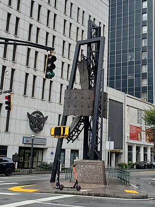
The Five Points Monument is a large public monument in Atlanta, Georgia, United States. Located in the Five Points district, the monument was designed by George Beasley and installed in 1996.