Related Research Articles

Little Five Points is a district on the east side of Atlanta, Georgia, United States, 2+1⁄2 miles (4.0 km) east of downtown. It was established in the early 20th century as the commercial district for the adjacent Inman Park and Candler Park neighborhoods, and has since become famous for the alternative culture it brings to Atlanta. It has been described as Atlanta's version of Haight-Ashbury, a melting pot of sub-cultures, and the bohemian center of the Southern United States.
East Atlanta is a neighborhood on the east side of Atlanta, Georgia, United States. The name East Atlanta Village primarily refers to the neighborhood's commercial district.
The Atlanta BeltLine is a 22 miles (35 km) open and planned loop of multi-use trail and light rail transit system on a former railway corridor around the core of Atlanta, Georgia. The Atlanta BeltLine is designed to reconnect neighborhoods and communities historically divided and marginalized by infrastructure, improve transportation, add green space, promote redevelopment, create and preserve affordable housing, and showcase arts and culture. The project is in varying stages of development, with several mainline and spur trails complete and others in an unpaved, but hikeable, state. Since the passage of the More MARTA sales tax in 2016, construction of the light rail streetcar system is overseen by MARTA in close partnership with Atlanta BeltLine, Inc.

Sylvan Hills is a historic intown neighborhood in southwest Atlanta, Georgia, United States.

Clear Creek is a stream in northeast Atlanta that is a tributary to Peachtree Creek and part of the Chattahoochee River watershed. It has two main branches, one originating east of the high ground along which Boulevard runs and another to the west originating on the northeast side of downtown Atlanta. The easterly branch of Clear Creek begins in several springs and branches in what are now Inman Park and the Old Fourth Ward. Flowing north, the creek was joined by other branches and springs, including Angier Springs near the end of Belgrade Avenue and the so-called Ponce de Leon Springs, which were “discovered” during railroad construction in the 1860s and gave rise to the eponymous park and avenue.

Westview is a historic intown neighborhood located in southwest Atlanta, Georgia. It is named for the Westview Cemetery that borders the neighborhood to the northwest. The neighborhood is made up of a mixture of architectural styles including Arts & Crafts bungalows, Four-Squares, Tudors, Minimal Traditional houses, and Ranch style houses.

Ponce de Leon Avenue, often simply called Ponce, provides a link between Atlanta, Decatur, Clarkston, and Stone Mountain, Georgia. It was named for Ponce de Leon Springs, in turn from explorer Juan Ponce de León, but is not pronounced as in Spanish. Several grand and historic buildings are located on the avenue.

Morningside/Lenox Park is an intown neighborhood in Atlanta, Georgia founded in 1923. It is located north of Virginia-Highland, east of Ansley Park and west of Druid Hills. Approximately 3,500 households comprise the neighborhood that includes the original subdivisions of Morningside, Lenox Park, University Park, Noble Park, Johnson Estates and Hylan Park.
Underwood Hills is a neighborhood in Buckhead Atlanta, Georgia, United States.

Capitol View is a historic intown southwest Atlanta, Georgia neighborhood. The neighborhood is 2.5 miles from downtown and was named for its views of the Georgia State Capitol building. Its boundaries include Metropolitan Parkway to the east, Lee Street to the west, and the Beltline to the north. On the south, the border follows Arden Street, Deckner Avenue, and Perkerson Park.
North Ormewood Park is a neighborhood on the east side of Atlanta, Georgia, United States, located in the northern part of Ormewood Park. It is located between Reynoldstown, East Atlanta and Grant Park and adjacent to the mixed-use development Glenwood Park. It is bordered by Moreland Avenue, Glenwood Avenue, I-20 and Stovall Avenue. It is a designated Drug Free Commercial Zone.
The Perkerson neighbourhood is located in Southwest Atlanta, Georgia, in NPU-X. The name change was made at the request of residents and members of the Perkerson Civic Association (PCA) in order to keep people from confusing the neighbourhood with Perkerson Park, which is the large park that serves the area.
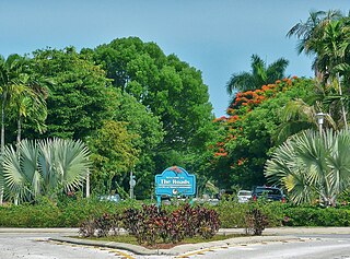
The Roads is a neighborhood of Miami in Miami-Dade County, Florida. It is a triangular area located south of SW 11th Street, between SW 12th Avenue and SW 15th Road, just west of Brickell.

South Downtown is a historic neighborhood of Downtown Atlanta, Georgia, United States. South Downtown is primarily home to city, county, state, and federal governmental offices, which prompted the city to adopt signage declaring the area "Government Walk." Although much of South Downtown is dominated by surface parking lots, the neighborhood was passed over during the redevelopment boom of the 1960s and 1970s that resulted in the demolition of much of Downtown's architecturally significant buildings. The result is myriad buildings from the 1950s and earlier that retain their historic structural integrity.
West Midtown, also known as Westside, is a colloquial area, comprising many historical neighborhoods located in Atlanta, Georgia. Once largely industrial, West Midtown is now the location of urban lofts, art galleries, live music venues, retail and restaurants.
Marietta Street Artery is an officially defined neighborhood of the city of Atlanta, Georgia, part of the West Midtown area of Atlanta, also known as the "Westside."
Lindbergh, officially Lindbergh/Morosgo, is a neighborhood in the Buckhead district of Atlanta, Georgia. Most of the neighborhood consists of multi-use development combining retail, office and residential space.
Midwest Cascade, also known as West Cascade, is an affluent predominantly African-American neighborhood in southwest Atlanta at the city's far west edge. Together with the tiny neighborhood of Regency Trace, it forms NPU-Q, the city's fastest growing Neighborhood Planning Unit (NPU) from 2000 to 2010.
Dixie Hills is a historic neighborhood of northwest Atlanta with a population of 1,756 (2010).
Bolton is a neighborhood of Atlanta, Georgia, in the Upper Westside, i.e. far northwest of the city. It is part of Neighborhood Planning Unit D. Bolton Road and Marietta Road are the main thoroughfares. Bolton Academy is located here and the neighborhood borders Crest View Memorial Park.
References
- ↑ 2010 U.S. census figures as tabulated by WalkScore
- ↑ https://striveatl.com/venetian-hills
- ↑ "Neighborhood Profile: Venetian Hills", City of Atlanta website
- ↑ Google (2014-08-22). "Venetian Hills, Atlanta, GA" (Map). Google Maps . Google. Retrieved 2014-08-22.
- ↑ https://striveatl.com/venetian-hills
- ↑ https://theatlantavoice.com/black-owned-media-company-ryse-interactive-closes-on-funding-to-begin-construction-on-25-million-dollar-innovative-creative-village-project/
- ↑ https://rysecreativevillage.com/
- ↑ https://www.ajc.com/news/local-education/aps-sell-one-the-former-schools-atlanta-deeds-dispute/Po9tjgdpKFACUqRCLD5nxM/