Capitol View, Atlanta

Last updated

Capitol View is a historic intown southwest Atlanta, Georgia neighborhood. The neighborhood is 2.5 miles from downtown and was named for its views of the Georgia State Capitol building. Its boundaries include Metropolitan Parkway to the east, Lee Street to the west, and the Beltline to the north. On the south, the border follows Arden Street, Deckner Avenue, and Perkerson Park.

Contents

Capitol View is filled with a housing stock of 1915-1925 craftsman bungalows as well as earlier Queen Anne houses that precede the planned development of the neighborhood. Several of the Queen Annes on Metropolitan Avenue were built by the Deckner family, for whom Decker Avenue is named. Many of the historic homes are rapidly being renovated as the neighborhood continues to revitalize and attract new residents.

Capitol View Neighborhood Association Banner CVBanner.jpg
Capitol View Neighborhood Association Banner
Perkerson Park Splash Pad Perkerson Park Splash Pad Playing Atlanta, GA.jpg
Perkerson Park Splash Pad

History

Early history

Original Capitol View plans East Capitol View Historical Layout1.jpg
Original Capitol View plans East
Original Capitol View plans West Capitol View historical plans 2014.jpg
Original Capitol View plans West

In the first and second decades of the 1900s, the residential area now known as Capitol View was little more than a farm and pasture owned primarily by A.P. Stewart, "Uncle John" Shannon and the Deckner family. There were no paved streets, no electric lights and no sewage system.

In 1858, the 12 charter members of Capitol View Baptist Church (then located on Beatie Avenue) went to church by lantern light. About 1912, the church was organized as a mission under the Second Baptist Church of Atlanta. [1] Between 1910 and 1914, the community began growing, largely due to the addition of a Masonic Temple and pharmacy to the area. By 1913, utilities were installed and Capitol View was annexed in the City of Atlanta.

The early 20th century trolley system revolutionized Capitol View and led to streets laid out in a grid pattern that has a longer north-south axis than east-west.

Commercial activity is concentrated along Dill Avenue, with a major commercial intersection at Dill and Metropolitan Parkway. This intersection has two prominent buildings, the 1921 Masonic Temple and the 1927 Capitol View Baptist Church (demolished in 2016) as well as several smaller commercial buildings.

Capitol View Streetscape Capitol View Streetscape.jpg
Capitol View Streetscape

Urban Renewal

Atlanta BeltLine Westside Trail Beltline Westside Trail Map.jpg
Atlanta BeltLine Westside Trail

In the late 1990s, Stewart Avenue was renamed Metropolitan Parkway in an effort to shake the street's unfortunate reputation as a haven of crime and prostitution. Since then Dill Ave restored the area have helped to increase property values and reduce crime. The approval of a Tax-allocation district for Metropolitan Parkway (although it does not include the Capitol View area) should help to revitalize a long-neglected business corridor. The redevelopment of the nearby Fort McPherson into a mixed use development/movie studio in the future will provide employment opportunities for existing and new residents. MARTA is also in the process of transitioning the Oakland City MARTA station into a transit-oriented development by converting existing parking lots into condos, apartments, and storefronts.

With the 2014 construction of the Beltline, the rising trend toward city living, and the new Metropolitan Branch library, Capitol View appears to be on a track for revitalization like many other in-town Atlanta neighborhoods.

BeltLine Westside Trail

The Atlanta BeltLine runs through the northern part of the Capitol View neighborhood, dropping south from Adair Park and crossing Metropolitan Avenue just north of Erin Avenue (in fact, that's the BeltLine bridge that you drive under on Metropolitan). From there, the BeltLine heads into neighboring Capitol View Manor.

In September 2013, the City of Atlanta was awarded an $18 million TIGER V grant from the U.S. Department of Transportation to develop the southwest corridor of the Atlanta BeltLine. In the second half of 2014, construction will commence on the 3-mile Westside Trail. The 3-mile Westside trail will run along the northern edge of Capitol View from University Avenue in Adair Park north to Lena Avenue at Washington Park in West End. For a half mile along White Street, the trail will use the existing West End Trail. The project funding includes 14 points of entry (11 of which will be ADA-accessible) with ramp and stair systems, greenway, and preservation for future transit. The construction is expected to start in the fall of 2014.

The Atlanta BeltLine Westside Trail groundbreaking took place on Wednesday, November 12 at 10:30 a.m. The Westside Trail, the next major milestone for the Atlanta BeltLine’s network of trails, transit, parks and green space will be a three-mile addition running from University Avenue in Adair Park to Lena Street at Washington Park. The design of the Westside Trail project was led by Atlanta BeltLine, Inc. in partnership with the Georgia Department of Transportation and support from a design team led by Kimley-Horn and Associates, Inc. The initial phase of a project this complex normally takes two years to complete. Yet the process took only nine months with the help of a unique partnership between the City of Atlanta, the Georgia Department of Transportation, the USDOT Federal Highway Administration, Atlanta BeltLine, Inc. and its design team. Construction of this project is expected to take approximately 24 months.

When completed, the Westside Trail will have a 14-foot wide concrete multi-use trail in this historic railroad corridor. The project will also include the construction of 14 access points, 11 of which are ADA-accessible, along with lighting, security cameras, signage, way-finding, mile-markers, and underground infrastructure. An expansion of the Atlanta BeltLine arboretum will blend with hundreds of large, native trees and integrate more than 30 acres of inviting and usable new green space. The project will be constructed in preparation for future transit that is currently in the planning stages. The Westside Trail connects four schools and four parks, as well as the residents of 10 southwest Atlanta neighborhoods to public transit, existing community businesses and future economic development sites. [2]

Neighborhood Association


Mission

Capitol View Neighborhood Association (CVNA) exists to improve the quality of life for Capitol View residents and to preserve, restore, and rejuvenate the neighborhood.

Community involvement includes subcommittees involved in Safety & Quality of Life, Communication and Engagement, and Economic Development. Activities are regularly held in Perkerson Park.

Transportation

MARTA Oakland City Train Station MARTA Oakland City.jpg
MARTA Oakland City Train Station

Capitol View is located just a few miles from Downtown Atlanta, Midtown Atlanta, Buckhead, College Park, East Point, Hartsfield-Jackson Atlanta International Airport, and major highways and interstates such as the Downtown Connector/I-75/I-85, I-20, and Metropolitan Parkway.

Public Transportation

Capitol View is located directly on the Red/Gold Lines of the MARTA Train Rail with a neighborhood stop at the Oakland City Train Station. This allows easy public transit options to the Atlanta area and beyond. In addition, Marta Bus stops line the perimeter of the neighborhood and surrounding areas.

Oakland City MARTA Station layout

P
Platform level
SouthboundGold Line toward Airport (Lakewood / Fort McPherson)
Red Line toward Airport (Lakewood / Fort McPherson)
Island platform, doors will open on the left
Northbound Gold Line toward Doraville (West End)
Red Line toward North Springs (West End)
GStreet LevelEntrance/Exit, fare barriers
LLower levelPassageway from street to platforms

Housing

Most homes in Capitol View were built during the first half of the twentieth century. Earlier home styles were primarily Country Victorians and Craftsman Bungalows while later housing stock included Cape Cods and Colonials. Most houses feature wide front porches and back decks looking out on spacious backyards. For several decades, many homes and streets in the neighborhood experienced major decline. However, since the 2010s, revitalization efforts led by investors have significantly improved numerous homes and streets in the area. [3] Today, houses in the neighborhood run the gamut of fixer-uppers to fully renovated historic homes to brand new home construction.

Prices reflect the condition and location of the property and as of May 2024 range from $300,000 to $700,000. [4] The neighborhood also has several industrial buildings which have been converted to lofts and are a part of the Coeur D'Allene loft complex.

Parks and Recreation

PerkersonPark PerkersonPark.jpg
PerkersonPark
Perkerson Park Splashpad Perkerson Park Splash Pad Opening Atlanta, GA 2014.jpg
Perkerson Park Splashpad

Capitol View is located between Perkerson Park and the proposed Atlanta Beltline park system. Perkerson is a 50-acre (200,000 m2) park with a large pavilion and several other picnic facilities. A new playground was recently installed during a renovation of the park's recreation center. In March 2010, the Friends of Perkerson Park, a community volunteer group, hosted the first "Spring Forward Festival" which raised money to make improvements to the park.

The park also features the following sport amenities:

Perkerson Park is home to one of two disc golf courses in the city of Atlanta.

Capitol View is also between two of the six targeted economic development areas on the Atlanta Beltline: Murphy's Crossing, directly north of Capitol View, and University/Metropolitan to the east.

Education

Atlanta Public Schools

Atlanta Metropolitan College Atlantametropolitancollege.jpg
Atlanta Metropolitan College

The Atlanta Public Schools for the neighborhood are:

Colleges and Universities

In addition, many colleges are located within a few miles of Capitol View. These include:

Metropolitan Library

Metropolitan Branch Rendering Metropolitan Branch.jpg
Metropolitan Branch Rendering

The Atlanta–Fulton Public Library System is currently building the Southwest Atlanta Branch Library in the neighborhood at 1332 Metropolitan Parkway, Atlanta, GA 30310. The Library System is engaged in a $275 million building program, funded by a library bond referendum approved by Fulton County voters in 2008. The project is divided into two phases.

Phase I of the Library Building Program consists of 10 projects, 8 new libraries – Alpharetta, East Roswell, Metropolitan, Milton, Northwest Atlanta, Palmetto, Southeast Atlanta, and Wolf Creek – and 2 expanded libraries – Auburn Avenue Research Library on African American Culture and History and South Fulton – with a total budget of $167 million; these dollars include everything from design and construction to funding for collections. Also, each library project includes a public art component, through the Fulton County Public Art Program.

Related Research Articles

<span class="mw-page-title-main">Midtown Atlanta</span> Neighborhood in Fulton County, Georgia, United States

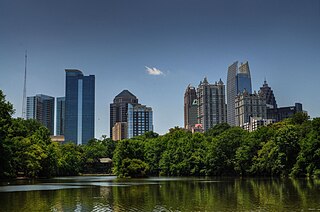
Midtown Atlanta, or Midtown, is a high-density commercial and residential neighborhood of Atlanta, Georgia. The exact geographical extent of the area is ill-defined due to differing definitions used by the city, residents, and local business groups. However, the commercial core of the area is anchored by a series of high-rise office buildings, condominiums, hotels, and high-end retail along Peachtree Street between North Avenue and 17th Street. Midtown, situated between Downtown to the south and Buckhead to the north, is the second-largest business district in Metro Atlanta. In 2011, Midtown had a resident population of 41,681 and a business population of 81,418.

The Atlanta BeltLine is a 22 miles (35 km) open and planned loop of multi-use trail and light rail transit system on a former railway corridor around the core of Atlanta, Georgia. The Atlanta BeltLine is designed to reconnect neighborhoods and communities historically divided and marginalized by infrastructure, improve transportation, add green space, promote redevelopment, create and preserve affordable housing, and showcase arts and culture. The project is in varying stages of development, with several mainline and spur trails complete and others in an unpaved, but hikeable, state. Since the passage of the More MARTA sales tax in 2016, construction of the light rail streetcar system is overseen by MARTA in close partnership with Atlanta BeltLine, Inc.

<span class="mw-page-title-main">Grove Park, Atlanta</span>

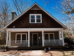
Grove Park is a northwest Atlanta, inside-the-perimeter neighborhood bounded by:

<span class="mw-page-title-main">Westside Park</span> Park in Atlanta, Georgia

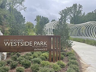
Westside Park at Bellwood Quarry is a park in the City of Atlanta located on the site of the former Bellwood Quarry. The park is between Johnson Road and Donald Lee Hollowell Parkway and between the neighborhoods of Bankhead, Grove Park, and Knight Park/Howell Station, of which a large portion of the park falls within the Grove Park boundaries. Westside Park at Bellwood Quarry was a major green space project of the Atlanta BeltLine master plan. The park has trail connectivity to the Proctor Creek Greenway Trail and will ultimately have connectivity to the BeltLine.

<span class="mw-page-title-main">Ashby station (MARTA)</span> MARTA rail station

Ashby is a train station in Atlanta, Georgia, serving the Blue and Green lines of the Metropolitan Atlanta Rapid Transit Authority (MARTA) rail system. It incorporates the use of split platforms, where the westbound platform is on the upper level and the eastbound platform is on the lower level. This is to facilitate the Green Line's split toward Bankhead, immediately west of this station.

<span class="mw-page-title-main">Bankhead station</span> MARTA rail station

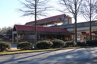
Bankhead is a train station in Atlanta, Georgia, the western terminus of the Green Line in the Metropolitan Atlanta Rapid Transit Authority (MARTA) rail system. Bankhead station is located in the Grove Park Neighborhood due to a recent neighborhood expansion. This station primarily serves the neighborhoods of Grove Park, Bankhead, West Lake, Howell Station, and other Westside residents. Bankhead Station provides connecting bus service to Donald Lee Hollowell Highway, Maddox Park, and the future Westside Park at Bellwood Quarry; which will be the largest park in the city of Atlanta

<span class="mw-page-title-main">Sylvan Hills, Atlanta</span> Neighbourhood of Atlanta, Georgia, United States

Sylvan Hills is a historic intown neighborhood in southwest Atlanta, Georgia, United States.

<span class="mw-page-title-main">Freedom Park (Atlanta, Georgia)</span>

Freedom Park is one of the largest city parks in Atlanta, Georgia, United States. The park forms a cross shape with the axes crossing at the Carter Center. The park stretches west-east from Parkway Drive, just west of Boulevard, to the intersection with the north-south BeltLine Eastside Trail, to Candler Park, and north-south from Ponce de Leon Avenue to the Inman Park/Reynoldstown MARTA station.

<span class="mw-page-title-main">Capitol View Manor</span>

Capitol View Manor is a small community in Southwest Atlanta that was named for the excellent view of the Georgia State Capitol building. Its boundaries include I-75/85 to the east, the Beltline to the north, Metropolitan Parkway to the west, and Atlanta Technical College to the south.

<span class="mw-page-title-main">Old Fourth Ward</span> Neighborhoods of Atlanta in Fulton County, Georgia, United States

The Old Fourth Ward, often abbreviated O4W, is an intown neighborhood on the eastside of Atlanta, Georgia, United States. The neighborhood is best known as the location of the Martin Luther King Jr. historic site.

<span class="mw-page-title-main">Perkerson Park</span> Park in Georgia, US

Perkerson Park is a 50-acre (200,000 m2) park in the Capitol View and Sylvan Hills neighborhoods of Atlanta, Georgia with many offerings such as disc golf, tennis courts, splash pads, an elaborate playground, recreational fields, all under the shady canopy of huge oak trees. The park is open 6:00 AM to 11:00 PM daily.

The Metropolitan Atlanta Rapid Transit Authority was created as the first public mass transit agency in metropolitan Atlanta. Its formation in 1965 was a result of the campaigning efforts of governmental planning agencies and Atlanta businessmen. The system broke ground on its rail system in 1975.

The Perkerson neighbourhood is located in Southwest Atlanta, Georgia, in NPU-X. The name change was made at the request of residents and members of the Perkerson Civic Association (PCA) in order to keep people from confusing the neighbourhood with Perkerson Park.

<span class="mw-page-title-main">Pittsburgh, Atlanta</span> United States historic place

Pittsburgh is a neighborhood of Atlanta, Georgia, founded in 1883 as a Black working-class suburb alongside the Pegram rail shops. It was named Pittsburgh because the industrial area reminded one of Pittsburgh, Pennsylvania and its famous steel mills. Pittsburgh is a working class and developing neighborhood, and as property values rise in Intown Atlanta neighborhoods, many see possibility that this trend will spread to Pittsburgh while bringing renewal for legacy residents.

<span class="mw-page-title-main">Streetcars in Atlanta</span> Aspect of the history of Atlanta, Georgia, USA

Streetcars originally operated in Atlanta downtown and into the surrounding areas from 1871 until the final line's closure in 1949.

<span class="mw-page-title-main">English Avenue and Vine City</span> Neighborhoods of Atlanta in Fulton, Georgia, United States

English Avenue and Vine City are two adjacent and closely linked neighborhoods of Atlanta, Georgia. Together the neighborhoods make up neighborhood planning unit L. The two neighborhoods are frequently cited together in reference to shared problems and to shared redevelopment schemes and revitalization plans.

Metropolitan Parkway, formerly known as Stewart Avenue, is a major thoroughfare through southwestern Atlanta, Georgia. It is signed throughout as US 19/US 41/SR 3.

Atlanta Georgia includes over 3,000 acres of parkland managed by Parks and Recreation. The 343 Atlanta parks range in scope from formal gardens at Atlanta Botanical Garden to pocket parks in neighborhoods. Additionally, there are six miles of paved pedestrian and bike trails in the Atlanta Beltline as well as the PATH Foundation network of 150 miles of off road trails.

<span class="mw-page-title-main">Transportation in Atlanta</span>

Atlanta's transportation system is a complex multimodal system serving the city of Atlanta, Georgia, widely recognized as a key regional and global hub for passenger and freight transportation. The system facilitates inter- and intra-city travel, and includes the world's busiest airport, several major freight rail classification yards, a comprehensive network of freeways, heavy rail, light rail, local buses, and multi-use trails.

<span class="mw-page-title-main">Timeline of the BeltLine</span>

This is the timeline of the development of the BeltLine, a ring of trails and parks around central Atlanta.

References

  1. "6 Feb 1927, 58 - The Atlanta Constitution at Newspapers.com". Newspapers.com. Retrieved 2022-08-31.
  2. "Atlanta BeltLine Meets Critical Milestone With Groundbreaking of Westside Trail // Atlanta BeltLine". beltline.org. 2014-11-05.
  3. https://www.11alive.com/article/news/atlanta-is-rapidly-gentrifying-heres-where/85-2fee7faa-212d-4960-9c4e-5b4b95a7181f
  4. "Capitol View, Atlanta, GA Recently Sold Homes".

33°43′00″N84°24′57″W / 33.71661°N 84.415947°W / 33.71661; -84.415947