Decatur is a city in, and the county seat of, DeKalb County, Georgia, which is part of the Atlanta metropolitan area. With a population of 24,928 in the 2020 census, the municipality is sometimes assumed to be larger since multiple ZIP Codes in unincorporated DeKalb County bear Decatur as the address. The city is served by three MARTA rail stations. The city is located approximately five miles northeast of Downtown Atlanta and shares its western border with both the city of Atlanta and unincorporated DeKalb County. The Druid Hills neighborhood is to the northwest of Decatur. The unofficial motto of Decatur used by some residents is "Everything is Greater in Decatur."
The Battle of Utoy Creek was fought August 4–7, 1864, during the Atlanta Campaign of the American Civil War. Maj. Gen. William T. Sherman's Union armies had partially encircled the city of Atlanta, Georgia, which was being held by Confederate forces under the command of General John Bell Hood. Sherman had at this point adopted a strategy of attacking the railroad lines into Atlanta, hoping to cut off his enemies' supplies. This was the third direct attack on Confederate positions during the campaign and the effect of success would have ended the siege and won Atlanta on 6 August 1864.
Kirkwood is a national historic designated neighborhood on the east side of Atlanta, Georgia, United States. It is a historic streetcar suburb situated entirely in DeKalb County, bordered by the neighborhoods of Lake Claire, East Lake, Edgewood, and Oakhurst. Kirkwood is bound on the north by DeKalb Avenue, on the south by Memorial Drive and Interstate 20, on the west by Montgomery Street, and on the east by 1st Ave. A large part of the neighborhood is listed on the National Register of Historic Places as Kirkwood Historic District.
Sandtown is a neighborhood located southwest of Atlanta, Georgia.
There were several historic mills around the metro Atlanta area, for which many of its current-day roads are still named. Most of the mills date back to the 1820s and 1830s, and were built along the area's many streams. The locations of many of these mills are shown on a map of 1875 showing U. S. military operations around Atlanta in 1864. This map is now located in the U. S. Library of Congress but can be seen on the webpage linked here.
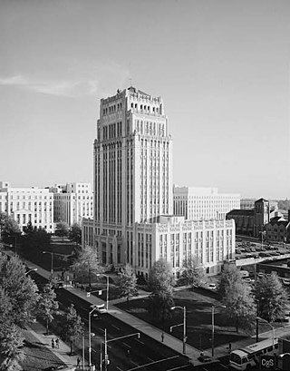
Atlanta City Hall is the headquarters of the City of Atlanta government. It was constructed in 1930, and is located in Downtown Atlanta. It is a high-rise office tower very similar to dozens of other city halls built in the United States during the same time period. Located in South Downtown, it is near other governmental structures, such as the Georgia State Capitol and the Fulton County Courthouse. The Neo-Gothic structure features many architectural details that have helped to make the building a historical landmark. It is Atlanta’s fourth city hall.

Cascade Heights is an affluent neighborhood in southwest Atlanta. It is bisected by Cascade Road, which was known as the Sandtown Road in the nineteenth century. The road follows the path of the ancient Sandtown Trail which ran from Stone Mountain to the Creek village of Sandtown on the Chattahoochee River and from there on into Alabama. Ironically, the name lived on even after the Indians were expelled in the 1830s.
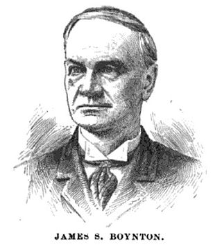
James Stoddard Boynton was an American politician and jurist.

Westview Cemetery, located in Atlanta, Georgia, is the largest civilian cemetery in the Southeastern United States, comprising more than 582 acres (2.36 km2), 50 percent of which is undeveloped. Westview includes the graves of more than 125,000 people, and was added to the Georgia Register of Historic Places in 2019 and the National Register of Historic Places in 2020.
Historic Collier Heights is an affluent middle-class and predominately African-American populated historic area in the northwest corner of Atlanta, Georgia. It is bordered to the west by Fairburn Road, the east by Hamilton E. Holmes Drive, the north by Donald L. Hollowell Parkway, and to the south by Interstate 20 bridge at Linkwood Road.
Winnona Park is a historic area in the southeast corner of the Atlanta, Georgia suburb of Decatur. It is listed as a historic district on the National Register of Historic Places, but it is not one of the City of Decatur's locally designated historic districts.

First Presbyterian Church of Atlanta is a congregation of the Presbyterian Church (U.S.A.) located in the Midtown section of Atlanta, Georgia. First Presbyterian Church was founded in 1848, and it was Atlanta's first Presbyterian house of worship. The original church building on Marietta Street was vacated in April 1916 and the property was sold to the U.S. government for the construction of the headquarters of the Federal Reserve Bank of Atlanta. The current church building on Peachtree Street was listed on the National Register of Historic Places in 2020.
Greenwood Cemetery is located at 1173 Cascade Circle SW, Atlanta, Fulton County, Georgia, United States.

Central Presbyterian Church is a historic church at 201 Washington Street SW in Atlanta, Georgia. It was founded in 1885 and was added to the National Register of Historic Places in 1986.

Midway Presbyterian Church and Cemetery is a historic Presbyterian church at 4635 Dallas Highway/GA 120 SW in Powder Springs, Georgia.

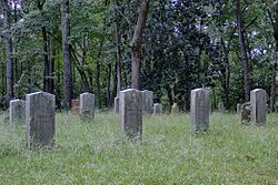
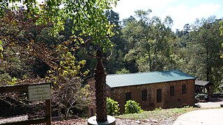
Utoy, Georgia was a small village located along Utoy Creek in present-day Fulton County, Georgia, USA. The vicinity, now part of metropolitan Atlanta, was the scene of the August 1864 Battle of Utoy Creek during the American Civil War and is today the site of Utoy Indian Village, a tourist center with renditions of historic Native-American structures and which offers a "Civil War Battlefield Tour."
Venetian Hills is an official neighborhood in southwest Atlanta, in the U.S. state of Georgia. Its 2010 population was 3,790.
The Roswell Historic District, in Roswell, Georgia in Fulton County, was listed on the National Register of Historic Places in 1974.