Clear Space Force Station

Last updated
Clear Space Force Station
Near Anderson, Alaska in the United States
Clear Air Force Station Alaska.jpg
An aerial image of Clear SFS in 1999.
Emblem of Space Base Delta 2.svg
USA Alaska location map.svg
Red pog.svg
Clear SFS
Location in the United States
Coordinates 64°17′26″N149°11′13″W / 64.29056°N 149.18694°W / 64.29056; -149.18694
TypeUS Space Force station
Site information
Owner Department of Defense
Operator United States Space Force
Controlled by Space Base Delta 2
ConditionOperational
Radar type AN/FPS-123
Site history
Built1949 (1949) (as Clear Air Force Auxiliary Field)
In use1949 – present
Garrison information
Occupants 13th Space Warning Squadron
213th Space Warning Squadron

Clear Space Force Station is a United States Space Force radar station for detecting incoming ICBMs and submarine-launched ballistic missiles [1] to NORAD's command center and to provide Space Surveillance data to the United States Space Force. Clear's AN/FPS-123 Upgraded Early Warning Radar is part of the Solid State Phased Array Radar System (SSPARS) which also includes those at Beale AFB, Cape Cod Space Force Station, RAF Fylingdales and Thule Site J. The "historic property" was one of the Alaska World War II Army Airfields and later a Cold War BMEWS site providing NORAD data to Colorado's BMEWS Central Computer and Display Facility (CC&DF).

Contents

In addition to the "original camp area" with buildings still in use today, [2] areas of the station include the airfield ( ICAO : PACL), the "SSPARS Site" [3] the technical site (Utilador, [4] BMEWS reflectors, support buildings, power plant), and the composite site (two permanent dormitories, a mess hall, recreation area, and administrative area).[ citation needed ] In addition to the Air National Guard unit, Clear has active duty USSF, Royal Canadian Air Force, civilian, and contractor personnel.

History

PAVE PAWS and BMEWS coverage PAVE PAWS&BMEWS.svg
PAVE PAWS and BMEWS coverage

The Alaska Railroad lay across some of the site. [5] The site was purchased by the Department of the Interior in 1949 for use as a gunnery range for Ladd Field. [2] The site became Clear Air Force Auxiliary Field.

In May 1958 total costs for the planned Thule and Clear BMEWS stations were estimated at ~$800 million. In October 1958 they were both estimated to be completed in September 1960. [6] An additional 10-by-40-mile (16 km × 64 km) area[ citation needed ] was appropriated for BMEWS Site II (cf. BMEWS Site I at Thule).

Clear is served by a spur of the Alaska Railroad, being about 15 kilometres (9.3 mi) south of Nenana and the Mears Memorial Bridge over the Tanana River that flows past Clear. This has transported coal for the power station and heavy equipment.

Clear Missile Early Warning Station

Clear Missile Early Warning Station construction began in August 1958 with 700 workers [7] —i.e., a "construction" camp was being erected in September 1958 by "Patti-McDonald and Morrison-Knudsen" [8] next to the railroad[ citation needed ] (for $1.7 million, 40,000 ft of railroad were moved by 1959.) [9] Groundbreaking for radar structures was May 1959[ citation needed ] ("Baker and Ford built a transmitter and computer building; a heat dissipation system; a radar transmitter building; wells and pumphouses; a fire station; and utilities") [9] and the AN/FPS-50 pedestals were complete by June 2, 1959. [10] In 1959 [11] after the original White Alice Communications System contract, "the next segment of WACS... was series of TD-2 microwave installations to support... two routes [that] linked the Ballistic Missile Early Warning Site (BMEWS) at Clear AFB... one going down the southeast coast (the A route) to the Ketchikan-Seattle submarine cable*, and the other, going east to the Canada–US border (B Route) through Canada, down to the lower 48 which was Clear's Rearward Communications System to Murphy Dome (A Route) and the Gold King Creek AFS (B Route) with data for the Ent AFB CC&DF. [12]

Three GE AN/FPS-50 Radar Sets were installed with antenna reflectors 165 by 400 feet (50 m × 122 m) that each weigh 1,000 short tons (910 t; 890 long tons). The "Building Two" middle transmitter building had the radar control room[ verification needed ] and room with the Sylvania AN/FSQ-28 Missile Impact Predictor Set. [13]

The "Clear Msl Early Warning Stn, Nenana, AK" was assigned to Hanscom Field, Massachusetts, on April 1, 1961, [14] and BMEWS Site II was completed July 1, 1961 [7] (the date of IOC--Full operational capability was declared three months later.)[ citation needed ]

Clear transferred to Air Defense Command in November 1961.[ citation needed ] By mid-1962, BMEWS "quick fixes" for ECCM had been installed at Thule and Clear [15] and by June 30, 1962, Ent AFB integration of BMEWS and SPADATS data was completed. [16] On July 31, 1962, NORAD recommended a tracking radar at Clear to close the BMEWS gap with Thule for low-angle missiles vice those with the 15-65 degree angle for which BMEWS was designed [15] (North Dakota's Cavalier AFS radar built in 1975 currently monitors for Hudson Bay launches.)

Missile warning operations

Detachment 2 of the 71st Missile Warning Wing was responsible for operations by civilian contractor personnel until 1964, when Air Force personnel began permanently manning the Tactical Operations Room (TOR).[ citation needed ]

In 1964, the Good Friday earthquake struck, and Clear was unable to perform its mission for six minutes. [17]

In 1966, the last of the five BMEWS tracking radars was installed, an RCA AN/FPS-92 Radar Set with an 84-foot (26 m) diameter antenna[ citation needed ] housed in a 42.7-meter (140 ft) diameter radome. [18] [19] [20] The FPS-92 was an improved AN/FPS-49 Radar Set variant with radome blocks having two high-density 1 millimeter thick skins that cover a 15 centimeter thick Kraft-paper core (total of 1,646 hexagonal and pentagonal blocks [21] (the hexagonal blocks were "66-inch panels".) [22] The completion of the FPS-92 raised the final construction price of the missile warning system at Clear to $300 million. $62 million of this figure had been spent by the Alaska District of the Corps of Engineers.) [9]

Clear provided emergency shelter for 216 flood refugees during August 1967, the same year many "temporary" buildings were replaced. Personnel at the installation subsequently provided measurements for a University of Alaska experiment which injected sulfur hexafluoride into the upper atmosphere to see if the Aurora Borealis could be affected.[ citation needed ] Clear had Bomb Alarm System equipment installed by the time the BAS was accepted on 10 February 1961. [23] The BAS was deactivated in 1970. [6] In 1975, the Secretary of Defense told Congress that Clear Air Force Station would be closed when the Shemya Island and Beale AFB radars became operational. [24] After a Thule radome fire, Clear's FPS-92 radome was replaced in 1981 by first disassembling the tracker, constructing the new radome, and reconstructing the FPS-92. [25] Clear's 1st all-female crew pulled its 1st shift on February 28, 1986 (the 1st female, Lt. Anderson was assigned in 1973.)

Beginning in 1987, ITT operated and maintained the Clear BMEWS under a USAF Space Command contract [21] and in the 1990s, the Southwest Research Institute upgraded Clear's pulse modulator for the transmitter final-stage power amplifier. [26]

Phased array radar

External images
Searchtool.svg Dogsled near FPS-50 reflectors
Searchtool.svg BMEWS radars after phased array was completed
Searchtool.svg AN/FPS-132 Upgraded Early Warning Radar

On April 16, 1998, groundbreaking for installing 1987 AN/FPS-115 PAVE PAWS components from Texas (e.g., the array elements) was held at Clear [27] for the more advanced Raytheon AN/FPS-120 [27] with 2500 "solid state transmitter" modules. [28] On December 15, 2000, the FPS-50 and −92 transmissions ceased[ citation needed ] (all of the Arecibo Observatory's Litton L-5773 klystrons were obtained as surplus from Clear's decommissioned BMEWS transmitters.) [29] Clear's FPS-120 began 24-hour operations[ citation needed ] when Clear's SSPARS Site (separate from the BMEWS site) had Initial Operational Capability on January 31, 2001; the date the entire SSPARS became operational [30] (SSPARS sites were modified in the Early Warning Radar Service Life Extension Program.) [31]

On August 30, 2006, after a transition that began in 2001, the ANG's 213th Space Warning Squadron took on the early warning/space surveillance mission.[ clarification needed ] BAE Systems began a 2007 contract for SSPARS maintenance, [32] and the Clear FPS-120 was subsequently upgraded to an AN/FPS-132 Upgraded Early Warning Radar (UEWR) [33] by Boeing Integrated Defense Systems [34] "featuring processor and software improvements to enhance capability." [20]

On 15 June 2021 it was renamed from Clear Air Force Station to Clear Space Force Station. [35]

Long Range Discrimination Radar was being tested at the base in 2022. [36]

Based units

The 11-story tall phased array building SSPARS radar, Clear AFB.JPG
The 11-story tall phased array building

Units based at Clear Space Force Station. [37] [38]

Those marked as GSU are Geographically Separate Units, which although based at Clear, are subordinate to a unit based at another location.

United States Space Force

Space Operations Command

United States Air Force

Alaska Air National Guard

Units to which assigned

Amateur radio restrictions

The US Code of Federal Regulations specifies that amateur radio operators within 160 kilometers of Clear must not transmit with more than 50 watts of power on the 70-centimeter band. [40]

Related Research Articles

<span class="mw-page-title-main">PAVE PAWS</span> Early warning radar

PAVE PAWS is a complex Cold War early warning radar and computer system developed in 1980 to "detect and characterize a sea-launched ballistic missile attack against the United States". The first solid-state phased array deployed used a pair of Raytheon AN/FPS-115 phased array radar sets at each site to cover an azimuth angle of 240 degrees. Two sites were deployed in 1980 at the periphery of the contiguous United States, then two more in 1987–95 as part of the United States Space Surveillance Network. One system was sold to Taiwan and is still in service.

<span class="mw-page-title-main">Ballistic Missile Early Warning System</span> US Cold War Early Warning Radar for ballistic missile defense

The RCA 474L Ballistic Missile Early Warning System was a United States Air Force Cold War early warning radar, computer, and communications system, for ballistic missile detection. The network of twelve radars, which was constructed beginning in 1958 and became operational in 1961, was built to detect a mass ballistic missile attack launched on northern approaches [for] 15 to 25 minutes' warning time also provided Project Space Track satellite data.

<span class="mw-page-title-main">Aerospace Defense Command</span> Former U.S. Air Force major command

Aerospace Defense Command was a major command of the United States Air Force, responsible for air defense of the continental United States. It was activated in 1968 and disbanded in 1980. Its predecessor, Air Defense Command, was established in 1946, briefly inactivated in 1950, reactivated in 1951, and then redesignated Aerospace rather than Air in 1968. Its mission was to provide air defense of the Continental United States (CONUS). It directly controlled all active measures, and was tasked to coordinate all passive means of air defense.

<span class="mw-page-title-main">Fort Fisher Air Force Station</span> Radar station in North Carolina, US 1955–1988

Fort Fisher Air Force Station was a United States Air Force installation located on the Atlantic coast 0.8 miles (1.3 km) southwest of Kure Beach, North Carolina. Its primary mission was as a radar complex. It was closed on 30 June 1988 by the Air Force, and turned over to the Federal Aviation Administration (FAA).

Mount Hebo Air Force Station is a closed United States Air Force General Surveillance Radar station. It is located 5.2 miles (8.4 km) east-southeast of Hebo, Oregon, located at the top of 3,154-foot (961 m) Mount Hebo. It was closed in 1980.

<span class="mw-page-title-main">Ground Equipment Facility J-33</span> Federal Aviation Administration (FAA) radar station

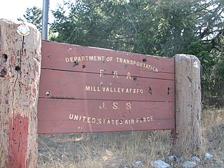
Ground Equipment Facility J-33 is a Federal Aviation Administration (FAA) radar station of the Joint Surveillance System's Western Air Defense Sector (WADS) with an Air Route Surveillance Radar (ARSR-4). The facility was previously a USAF general surveillance radar station during the Cold War.

<span class="mw-page-title-main">Watertown Air Force Station</span> Closed United States Air Force ADCOM General Surveillance Radar station

Watertown Air Force Station is a closed United States Air Force ADCOM General Surveillance Radar station 3.5 miles (5.6 km) south of Watertown, New York. Prior to the Air Defense squadron inactivating on 1 November 1979, the station was reassigned to Tactical Air Command which maintained the Ground Air Transmitter Receiver until early 1984. A New York State jail opened at the site c. 1983.

<span class="mw-page-title-main">Eldorado Air Force Station</span> Military installation

Eldorado Air Force Station located 35 miles (56 km) south of San Angelo, Texas was one of the four unique AN/FPS-115 PAVE PAWS, early-warning phased-array radar systems. The 8th Space Warning Squadron, 21st Space Wing, Air Force Space Command operated at Eldorado Air Force Station.

<span class="mw-page-title-main">9th Space Warning Squadron</span> Military unit

The United States Air Force's 9th Space Warning Squadron was a United States Air Force missile warning unit located at Robins AFB, Georgia.

<span class="mw-page-title-main">Ground Equipment Facility QRC</span> FAA radar station

Ground Equipment Facility QRC is an FAA radar station that was part of a Cold War SAGE radar station for aircraft control and warning "from Massachusetts to southern Virginia, and as far out to sea as possible." Benton AFS was also the first operational "regional data processing center" for the GE 477L Nuclear Detection and Reporting System.

<span class="mw-page-title-main">Murphy Dome Air Force Station</span>

Murphy Dome Air Force Station is a closed United States Air Force General Surveillance Radar station 20.4 miles (32.8 km) west-northwest of Fairbanks, Alaska.

The Avco AN/FPS-26 Radar was an Air Defense Command height finder radar developed in the Frequency Diversity Program with a tunable 3-cavity power klystron for electronic counter-countermeasures (e.g. to counter jamming). Accepted by the Rome Air Development Center on 20 January 1960 for use at SAGE radar stations, the AN/FPS-26 processed height-finder requests (e.g., from Air Defense Direction Centers) by positioning to the azimuth of a target aircraft using a high-pressure hydraulic drive, then "nodding" in either a default automatic mode or by operator command. The inflatable radome required a minimum pressure to prevent contact with the antenna which would result in damage to both (technicians accessed the antenna deck via an air lock.) To maintain high dielectric strength, the waveguide was pressurized with sulfur hexafluoride (SF6), which technicians were warned would produce deadly fluorine if waveguide arcing occurred.

Port Austin Air Force Station is a closed United States Air Force General Surveillance Radar station. It is located 1.2 miles (1.9 km) south-southwest Port Austin, Michigan. It was closed in 1988 by the Air Force.

<span class="mw-page-title-main">14th Test Squadron</span> Military unit

The 14th Test Squadron is a United States Air Force unit located at Schriever Air Force Base, Colorado. It is an Air Force Reserve unit that augments the 17th Test Squadron. The squadron is responsible for testing and evaluating space systems and associated support equipment. The unit was originally established in 1972 as the 14th Missile Warning Squadron. The missile warning squadron was an active duty unit that operated early warning radars at eight locations around the United States until it was inactivated in 1980. The squadron was reactivated and given its current space test mission in 2000.

<span class="mw-page-title-main">213th Space Warning Squadron</span> Unit of the Alaska Air National Guard

The 213th Space Warning Squadron of the Alaska Air National Guard provides early warning of Intercontinental ballistic missiles and Submarine-launched ballistic missiles to the Missile Correlation Center of North American Aerospace Defense Command. The squadron is a geographically separated unit assigned to the 168th Wing at Eielson Air Force Base.

<span class="mw-page-title-main">Solid State Phased Array Radar System</span>

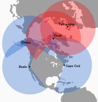
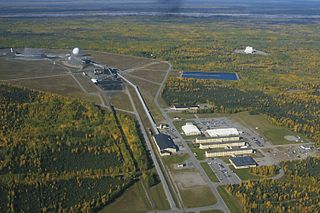
The Solid State Phased Array Radar System is a United States Space Force radar, computer, and communications system for missile warning and space surveillance. There are SSPARS systems at five sites: Beale Air Force Base, CA, Cape Cod Space Force Station, MA, Clear Space Force Station, AK, RAF Fylingdales, UK, and Pituffik Space Base, Greenland. The system completed replacement of the RCA 474L Ballistic Missile Early Warning System when the last SSPAR was operational at then-Clear Air Force Station in 2001.

<span class="mw-page-title-main">Thule Site J</span> United States Space Force radar station in Greenland

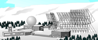
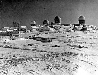
Thule Site J (J-Site) is a United States Space Force (USSF) radar station in Greenland near Pituffik Space Base for missile warning and spacecraft tracking. The northernmost station of the Solid State Phased Array Radar System, the military installation was built as the 1st site of the RCA 474L Ballistic Missile Early Warning System and had 5 of 12 BMEWS radars. The station has the following structures:

<span class="mw-page-title-main">AN/FPQ-16 PARCS</span> United States Space Force phased-array radar system located in North Dakota

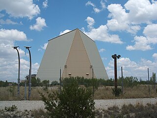
The AN/FPQ-16 Perimeter Acquisition Radar Attack Characterization System is a powerful United States Space Force phased-array radar system located in North Dakota. It is the second most powerful phased array radar system in the US Space Force's fleet of missile warning and space surveillance systems, behind the more modern PAVE PAWS phased array radar.

<span class="mw-page-title-main">Missile Warning Center</span> Military unit

The Missile Warning Center (MWC) is a center that provides missile warning and defense for United States Space Command's Combined Force Space Component Command, incorporating both space-based and terrestrial sensors. The MWC is located at Cheyenne Mountain Space Force Station.

<span class="mw-page-title-main">Eglin AFB Site C-6</span> Transmitter/receiver building in Walton County, United States

Eglin AFB Site C-6 is a United States Space Force radar station which houses the AN/FPS-85 phased array radar, associated computer processing system(s), and radar control equipment designed and constructed for the U. S. Air Force by the Bendix Communications Division, Bendix Corporation. Commencing operations in 1969, the AN/FPS-85 was the first large phased array radar. The entire radar/computer system is located at a receiver/transmitter building and is supported by the site's power plant, fire station, 2 water wells, and other infrastructure for the system. As part of the US Space Force's Space Surveillance Network its mission is to detect and track spacecraft and other manmade objects in Earth orbit for the Combined Space Operations Center satellite catalogue. With a peak radiated power of 32 megawatts the Space Force claims it is the most powerful radar in the world, and can track a basketball-sized object up to 22,000 nautical miles (41,000 km) from Earth.

References

  1. "Clear AFS". GlobalSecurity.org. 2005-04-27. Retrieved 2009-11-04.
  2. 1 2 Cold War Historic Properties of the 21st Space Wing Air Force Space Command (PDF) (Report). OSTI.gov. Retrieved 2008-11-04.
  3. "Clear Air Force Station, Alaska". Airforce-technology.com. Retrieved 23 July 2022.
  4. "Clear "Utilador"". Lcweb2.loc.gov. Retrieved 23 July 2022.
  5. Cultural Resources Survey and Management Plan of the Clear Air Force Station (PDF) (Report). ORNL.gov. 1991. Archived from the original (PDF) on 2012-09-27. Retrieved 2008-11-04.
  6. 1 2 Wainstein, L. (June 1975). The Evolution of U.S. Strategic Command and Control and Warning: Part One (1945-1953) (PDF) (Report). Vol. Study S-467. Institute for Defense Analyses. pp. 1–138. Archived (PDF) from the original on March 11, 2014. Retrieved 2014-03-09.
  7. 1 2 "Watchful eye of BMEWS turns toward Soviets" (Google news archive). Ellensburg Daily Record. June 18, 1961. Retrieved 2014-03-09.
  8. page 269 "William A. Smith Contracting relocated a 40,000-foot length of the railroad.", Poa.usace.army.mil
  9. 1 2 3 "VIII : Military Construction : Creating a Permanent Military Establishment in Alaska" (PDF). Poa.usace.army.mil. Retrieved 23 July 2022.
  10. Rogers, Warren Jr. (June 2, 1960). "Summit Failure Speeds Up Development of BMEWS". Herald Tribune News Service. Retrieved 2014-03-09.
  11. Installation Restoration Program Preliminary Assessment: Gold King Creek Radio Relay Station, Alaska (PDF) (Report). Hazardous Materials Technical Center. April 1989. Archived (PDF) from the original on April 16, 2014. Retrieved 2014-04-14. The RRS originally consisted of one radio relay building, one microwave tower enclosed by a chain link fence, and a 2,050-foot runway. These facilities total 30.32 acres. Two 14,000-gallon steel underground diesel fuel storage tanks are located west of the building. Figure 3 shows the original facilities at Gold King Creek RRS.
  12. "Rabbit Creek White Alice Site" (PDF). Archived from the original (PDF) on 2012-10-12. Retrieved 2014-04-15.
  13. McManus, Gene (September 1996). "BMEWS - 51- Full Days". Bwcinet.com. Archived from the original on 2009-01-14. Retrieved 2014-03-19.
  14. Mueller, Robert (1989). Air Force Bases (PDF) (Report). Vol. I: Active Air Force Bases Within the United States of America on 17 September 1982. Office of Air Force History. p. 600. ISBN   0-912799-53-6 . Retrieved 2013-08-15. Gold King Creek AFS (rdsgd Gold King Creek RR Site) (detchd instl), 45 mi NE of Fairbanks, AK, 16 Jul 1959 (dsgd)... Wideawake Fld (rdsgd Ascension Isl Aux Fid)... Ascension Isl, South Atlantic Ocean, 25 Jun 1956 (actvd)
  15. 1 2 1962 NORAD/CONAD Historical Summary, July-December, Northcom.mil
  16. Del Papa, Dr. E. Michael; Warner, Mary P (October 1987). A Historical Chronology of the Electronic Systems Division 1947-1986 (PDF) (Report). Archived (PDF) from the original on December 24, 2013. Retrieved 2014-03-08. 7 November [1984] Installation of [SSPARS] radar hardware at Site I, Thule, Greenland, for the Ballistic Missile Early Warning System (BMEWS) was begun.
  17. McCann, Chris (24 March 2014). "50 YEARS since 1964 earthquake catastrophe: Military integral to recovery". Pacific Air Forces . Retrieved 12 May 2024.
  18. "The Morning Record - Google News Archive Search". News.google.com. Retrieved 23 July 2022.
  19. "Electronic Eye Watches For Sneak Missile Attack" (Google news archive). Herald-Journal. July 8, 1966. Retrieved 2014-03-09.
  20. 1 2 "[6.0] Miscellaneous Topics". Vectorsite.net.
  21. 1 2 "Draft : The Coldest Front : Cold War Military Properties in Alska" (PDF). Nikesummit.net. Retrieved 23 July 2022.
  22. "Reading Eagle - Google News Archive Search". News.google.com. Retrieved 23 July 2022.
  23. Space and Missile Systems Organization: A Chronology, 1954-1979
  24. "ALERT" (PDF). Dod.mil. Archived from the original (PDF) on 27 November 2011. Retrieved 23 July 2022.
  25. "Clear Air Force Station, Alaska". Themilitarystandard.com. Retrieved 23 July 2022.
  26. Grimes, M. D.; Grothaus, M. G.; North, W. R.; Brittain, D.; Norander, R.; Kajonpong, D. (1 July 1995). "A new modulator design for the BMEWS transmitter". Digest of Technical Papers. Tenth IEEE International Pulsed Power Conference. Vol. 1. pp. 688–693 vol.1. doi:10.1109/PPC.1995.596791. ISBN   0-7803-2791-8. S2CID   109329176 via IEEE Xplore.
  27. 1 2 Pike, John. "Clear AFS". Globalsecurity.org.
  28. Skolnik, Merrill I (1990). Radar Handbook (PDF) (2nd ed.). McGraw-Hill. ISBN   978-0-07-057913-2 . Retrieved 2014-04-14.
  29. "Arecibo 430 MHz Radar System Operation and Maintenance Manual" (PDF). Naic.edu. Retrieved 23 July 2022.
  30. "Clear AFS, AK". GlobalSecurity.org. Retrieved 2014-03-05.
  31. Chapman, Bert (2008). Space Warfare and Defense: A Historical Encyclopedia and Research Guide. p. 153. ISBN   978-1-59884-006-3. BMEWS was replaced by the Solid State Phased Array Radar System (SSPARS) in 2001. ... CINCAD (Command in Chief, Aerospace Defense Command)
  32. "BAE Systems To Continue Maintaining SSPARS Radar Network for U.S. Air Force - SpaceNews.com". 3 March 2014. Archived from the original on March 19, 2014.
  33. "U.S. to Sell Large Early Warning Radar to Qatar (August 7, 2013) (corrected February 10, 2014)". Mostlymissiledefense.com. 7 August 2013.
  34. "Fylingdales". Raytheon.co.uk. Archived from the original on 2014-03-11. Retrieved 2014-03-08.
  35. "Clear Air Force Station renamed as Clear Space Force Station". Buckley.spaceforce.mil.
  36. "Long-range missile defense radar ready to 'plug in' at NORTHCOM within 'months'". 10 August 2022.
  37. "Fact Sheet – Space Delta 4 - Missile Warning". Buckley Air Force Base. US Space Force. July 2020. Retrieved 2 August 2020.
  38. Mann, Senior Master Sgt. Paul (20 July 2018). "Clear welcomes a familiar face as new commander". DVIDS. US Department of Defense. Retrieved 2 August 2020.
  39. compiled by Johnson, Mildred W. (31 December 1980) [Feb 1973 original by Cornett, Lloyd H. Jr.]. A Handbook of Aerospace Defense Organization 1946 - 1980 (PDF). Peterson AFB: Office of History, Aerospace Defense Center. Archived from the original (PDF) on 2016-02-13. Retrieved 2012-03-26.
  40. "47 CFR §2.106 - Footnote US270" . Retrieved 2023-04-26.