An anti-ballistic missile (ABM) is a surface-to-air missile designed to counter ballistic missiles. Ballistic missiles are used to deliver nuclear, chemical, biological, or conventional warheads in a ballistic flight trajectory. The term "anti-ballistic missile" is a generic term for a system designed to intercept and destroy any type of ballistic threat; however, it is commonly used for systems specifically designed to counter intercontinental ballistic missiles (ICBMs).

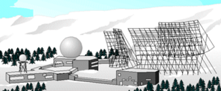
PAVE PAWS is a complex Cold War early warning radar and computer system developed in 1980 to "detect and characterize a sea-launched ballistic missile attack against the United States". The first solid-state phased array deployed used a pair of Raytheon AN/FPS-115 phased array radar sets at each site to cover an azimuth angle of 240 degrees. Two sites were deployed in 1980 at the periphery of the contiguous United States, then two more in 1987–95 as part of the United States Space Surveillance Network. One system was sold to Taiwan and is still in service.
The Aegis ballistic missile defense system, also known as Sea-Based Midcourse, is a Missile Defense Agency program under the United States Department of Defense developed to provide missile defense against short and intermediate-range ballistic missiles. The program is part of the United States national missile defense strategy and European NATO missile defense system.

National missile defense (NMD) refers to the nationwide antimissile program the United States has had in development since the 1990s. After the renaming in 2002, the term now refers to the entire program, not just the ground-based interceptors and associated facilities.
The RCA 474L Ballistic Missile Early Warning System was a United States Air Force Cold War early warning radar, computer, and communications system, for ballistic missile detection. The network of twelve radars, which was constructed beginning in 1958 and became operational in 1961, was built to detect a mass ballistic missile attack launched on northern approaches [for] 15 to 25 minutes' warning time also provided Project Space Track satellite data.
Ground-Based Midcourse Defense (GMD), previously National Missile Defense (NMD), is an anti-ballistic missile system implemented by the United States of America for defense against ballistic missiles, during the midcourse phase of ballistic trajectory flight. It is a major component of the American missile defense strategy to counter ballistic missiles, including intercontinental ballistic missiles (ICBMs) carrying nuclear, chemical, biological or conventional warheads.
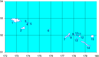
Shemya or Simiya is a small island in the Semichi Islands group of the Near Islands chain in the Aleutian Islands archipelago southwest of Alaska, at 52°43′27″N174°07′08″E. It has a land area of 5.903 sq mi (15.29 km2), and is about 1,200 miles (1,900 km) southwest of Anchorage, Alaska. It is 2.73 miles (4.39 km) wide and 4.32 miles (6.95 km) long.

The Missile Defense Agency (MDA) is a component of the United States government's Department of Defense responsible for developing a comprehensive defense against ballistic missiles. It had its origins in the Strategic Defense Initiative (SDI) which was established in 1983 by Ronald Reagan and which was headed by Lt. General James Alan Abrahamson. Under the Strategic Defense Initiative's Innovative Sciences and Technology Office headed by physicist and engineer Dr. James Ionson, the investment was predominantly made in basic research at national laboratories, universities, and in industry. These programs have continued to be key sources of funding for top research scientists in the fields of high-energy physics, advanced materials, nuclear research, supercomputing/computation, and many other critical science and engineering disciplines—funding which indirectly supports other research work by top scientists, and which was most politically viable to fund from appropriations for national defense. It was renamed the Ballistic Missile Defense Organization in 1993, and then renamed the Missile Defense Agency in 2002. The current director is U.S. Navy Vice Admiral Jon A. Hill.

The United States Space Surveillance Network (SSN) detects, tracks, catalogs and identifies artificial objects orbiting Earth, e.g. active/inactive satellites, spent rocket bodies, or fragmentation debris. The system is the responsibility of United States Space Command and operated by the United States Space Force and its functions are:

Eareckson Air Station, formerly Shemya Air Force Base, is a United States Air Force military airport located on the island of Shemya, in the Alaskan Aleutian Islands.

The AN/SPQ-11 Cobra Judy was a PESA radar found on the USNS Observation Island (T-AGM-23) missile range instrumentation ship.

Kura Missile Test Range, originally known as Kama, is a Russian intercontinental ballistic missile impact area located in northern Kamchatka Krai in the Russian Far East. It is the destination for ballistic missiles which are test fired from other centers, and was chosen due to its remoteness and distance. It is 130 kilometers (81 mi) northeast of the settlement of Klyuchi and the military townlet is called Klyuchi-1, after the nearest settlement.

The AN/FPS-17 was a ground-based fixed-beam radar system that was installed at three locations worldwide, including Pirinçlik Air Base in south-eastern Turkey, Laredo, Texas and Shemya Island, Alaska.

The 16th Electromagnetic Warfare Squadron is an active United States Space Force unit, stationed at Peterson Space Force Base, Colorado as part of the Space Delta 3. The squadron protects critical satellite communication links to detect, characterize, geolocate and report sources of electromagnetic interference on US military and commercial satellites. The squadron also provides combat-ready crews to deploy and employ defensive space electromagnetic warfare capabilities for theater combatant commanders. The squadron is Air Force Space Command's first defensive counterspace unit.

The 1st Space Operations Squadron is a United States Space Force unit responsible for space-based space domain awareness. Located at Schriever Space Force Base, Colorado, the squadron operates the Space Based Space Surveillance system, the Advanced Technology Risk Reduction system, the Operationally Responsive Space-5 satellite, and the Geosynchronous Space Situational Awareness Program.
The Space Tracking and Surveillance System was a pair of satellites developed by the United States Missile Defense Agency (MDA) to research the space-based detection and tracking of ballistic missiles. Data from STSS satellites could allow interceptors to engage incoming missiles earlier in flight than would be possible with other missile detection systems. The STSS program began in 2001, when the "SBIRS Low" program was transferred to MDA from the United States Air Force. In December 2002, SBIRS Low Research & Development was renamed Space Tracking and Surveillance System (STSS).
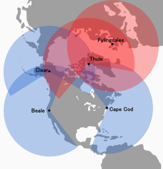
The Solid State Phased Array Radar System is a United States Space Force radar, computer, and communications system for missile warning and space surveillance. There are SSPARS systems at five sites: Beale Air Force Base, CA, Cape Cod Space Force Station, MA, Clear Space Force Station, AK, RAF Fylingdales, UK, and Pituffik Space Base, Greenland. The system completed replacement of the RCA 474L Ballistic Missile Early Warning System when the last SSPAR was operational at then-Clear Air Force Station in 2001.

Eglin AFB Site C-6 is a United States Space Force radar station which houses the AN/FPS-85 phased array radar, associated computer processing system(s), and radar control equipment designed and constructed for the U. S. Air Force by the Bendix Communications Division, Bendix Corporation. Commencing operations in 1969, the AN/FPS-85 was the first large phased array radar. The entire radar/computer system is located at a receiver/transmitter building and is supported by the site's power plant, fire station, 2 water wells, and other infrastructure for the system. As part of the US Space Force's Space Surveillance Network its mission is to detect and track spacecraft and other manmade objects in Earth orbit for the Combined Space Operations Center satellite catalogue. With a peak radiated power of 32 megawatts the Space Force claims it is the most powerful radar in the world, and can track a basketball-sized object up to 22,000 nautical miles (41,000 km) from Earth.
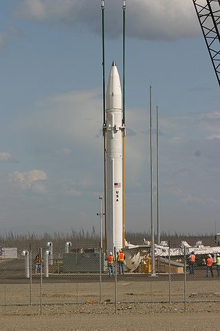
The Ground-Based Interceptor (GBI) is the anti-ballistic missile component of the United States' Ground-Based Midcourse Defense (GMD) system.

The AN/TPY-2 Surveillance Transportable Radar, also called the Forward Based X-Band Transportable (FBX-T) is a long-range, very high-altitude active digital antenna array X band surveillance radar designed to add a tier to existing missile and air defence systems. It has a range of 2,900 mi. Made by Raytheon, it is the primary radar for the Terminal High Altitude Area Defense (THAAD) missile system, but also cues the AN/MPQ-53 radar of the MIM-104 Patriot system. Patriot PAC-3 is a lower-altitude missile and air defense system than THAAD.


