United States Space Surveillance Network

Last updated

The United States Space Surveillance Network (SSN) detects, tracks, catalogs and identifies artificial objects orbiting Earth, e.g. active/inactive satellites, spent rocket bodies, or fragmentation debris. The system is the responsibility of United States Space Command and operated by the United States Space Force and its functions are:

Contents

The Space Surveillance Network includes dedicated, collateral, and contributing electro-optical, passive radio frequency (RF) and radar sensors. It provides space object cataloging and identification, satellite attack warning, timely notification to U.S. forces of satellite fly-over, space treaty monitoring, and scientific and technical intelligence gathering. The continued increase in satellite and orbital debris populations, as well as the increasing diversity in launch trajectories, non-standard orbits, and geosynchronous altitudes, necessitates continued modernization of the SSN to meet existing and future requirements and ensure their cost-effective supportability. [1]

SPACETRACK also developed the systems interfaces necessary for the command and control, targeting, and damage assessment of a potential future U.S. anti-satellite weapon (ASAT) system. There is an Image Information Processing Center and Supercomputing facility at the Air Force Maui Optical Station (AMOS).

History

1957–1963

Baker-Nunn satellite tracking camera Baker-Nunn camera.jpg
Baker-Nunn satellite tracking camera

The first formalized effort by the US government to catalog satellites occurred at Project Space Track, later[ when? ] known as the National Space Surveillance Control Center (NSSCC), located at Hanscom Field in Bedford, Massachusetts. The procedures used at the NSSCC were first reported in 1959 and 1960 by Wahl, [2] who was the technical director of the NSSCC. In 1960, under Project Space Track, Fitzpatrick and Findley developed detailed documentation of the procedures used at the NSSCC. [3] Project Space Track began its history of satellite tracking from 1957–1961.

Early Space Track observations of satellites were collected at more than 150 individual sites, including radar stations, Baker–Nunn cameras, telescopes, radio receivers, and by citizens participating in the Operation Moonwatch program. Individuals at these Moonwatch sites recorded observations of satellites by visual means, but there were numerous observation types and sources, some automated, some only semi-automated. The observations were transferred to the NSSCC by teletype, telephone, mail, and personal messenger. There, a duty analyst reduced the data and determined corrections[ clarification needed ] that should be made to the orbital elements[ clarification needed ] before they were used for further predictions. After this analysis, the corrections were fed into an IBM 709 computer that computed the updated orbital data. The updated orbital data were then used in another phase of the same computer program to yield the geocentric ephemeris. From the geocentric ephemeris, three different products were computed and sent back to the observing stations for their planning of future observing opportunities. [3]

Missile Warning and Space Surveillance in the Eisenhower Years

The launch of Sputnik 1 by the Soviet Union led to a US government perceived need to better track objects in space using the Space Tracking System. The first US system, Minitrack, was already in existence at the time of the Sputnik launch, but the US quickly discovered that Minitrack could not reliably detect and track satellites. The US Navy designed Minitrack to track the Vanguard satellite, and so long as satellites followed the international agreement on satellite transmitting frequencies, Minitrack could track any satellite. However, the Soviets chose not to use the international satellite frequencies. Thus, a major limitation of this system became visible. Minitrack could not detect or track an uncooperative or passive satellite. [4]

Concurrent[ citation needed ] with Minitrack was the use of the Baker-Nunn satellite tracking cameras. These systems used modified Schmidt telescopes of great resolution to photograph and identify objects in space. The cameras first became operational in 1958 and eventually operated at sites worldwide. At their peak, the Air Force ran five sites, the Royal Canadian Air Force ran two, and the Smithsonian Institution's Astrophysics Observatory operated a further eight sites. The Baker-Nunn system, like Minitrack, provided little real-time data and was additionally limited to night-time, clear weather operations. [4]

Beyond the problems in acquiring data on satellites, it became obvious that the US tracking network would soon be overwhelmed by the tremendous number of satellites that followed Sputnik and Vanguard. The amount of satellite tracking data accumulated required creation or expansion of organizations and equipment to sift through and catalog the objects. The need for real-time detection and tracking information to deal with Soviet satellite launches led on 19 December 1958 to ARPA's implementation of Executive Order 50-59 to establish a spacetrack network. This spacetrack network, Project Shepherd, began with the Space Track Filter Center at Bedford, Massachusetts, and an operational space defense network (i.e., a missile warning network). ARDC took up the spacetrack mission in late 1959 and in April 1960 set up the Interim National Space Surveillance Control Center at Hanscom Field, Massachusetts, to coordinate observations and maintain satellite data. At the same time, DOD designated the Aerospace Defense Command (ADCOM), formerly Air Defense Command, as the prime user of spacetrack data. ADCOM formulated the first US plans for space surveillance. [4]

During the years that intercontinental ballistic missiles were developing as frontline weapon systems, numerous missile detection and warning sensors were being experimented with and fielded as operational sensors and most of these contributed satellite observation data at one time or another. Many have been overlooked by current histories and additional research is merited. Among these were two Trinidad detection and tracking radars; Laredo, Texas; and Moorestown, New Jersey. Additional sensors that performed or contributed to space tracking but are not yet included in this page include mechanical tracking radars on the islands of Kaena Point, Antigua, Ascension Island, Naval Station San Miguel, and Kwajalein Atoll; the three BMEWS sites; the Pave Paws sites; the AN/FSS-7 missile warning radar sites; the Passive electronically scanned array sites; Cavalier, ND; Eglin, FL; Maui Space Surveillance System; Globus II; San Vito dei Normanni Air Station; TOS/CROSS; and MIT Lincoln Laboratory.[ citation needed ]

Air Force Space Surveillance System

The Air Force Space Surveillance System (AFSSS), also known as the "space fence", was a very high frequency radar network located at sites across the southern United States (from California to Georgia) with a centralized data processing site at the Naval Network and Space Operations Command in Dahlgren, Virginia. AFSSS began as the Navy's Space Surveillance (SPASUR) system in 1961 (later renamed NAVSPASUR). It was transferred to the Air Force in 2004 and renamed AFSSS. The "fence" was operated by the U.S. Air Force (20th Space Control Squadron Detachment 1).

The Satellite Detection and Reconnaissance Defense (the former designation of the NSSS) reached initial operating capability in 1961. The role of the "fence" grew. The system detected space objects from new launches, maneuvers of existing objects, breakups of existing objects, and provided data to users from its catalog of space objects. Orbital parameters of more than 10,000 objects were maintained in this catalog—which has now gained usage by NASA, weather agencies, and friendly foreign agencies. The information is essential to computing the collision avoidance information to de-conflict launch windows with known orbiting space objects.

The 21st Space Wing closed the Air Force Space Surveillance System on 1 October 2013 citing resource constraints caused by sequestration. [5] A new S-band Space Fence is under construction at Kwajalein Atoll. [6] [7]

US Space Catalog

The United States Department of Defense (DoD) has maintained a database of satellite states since the launch of the first Sputnik in 1957, known as the Space Object Catalog, or simply the Space Catalog. These satellite states are regularly updated with observations from the Space Surveillance Network, a globally distributed network of interferometer, radar and optical tracking systems. By the year 2001, the number of cataloged objects was nearly 20,000. [8] [9] [10]

Different astrodynamics theories are used to maintain these catalogs. The General Perturbations (GP) theory provides a general analytical solution of the satellite equations of motion. The orbital elements and their associated partial derivatives are expressed as series expansions in terms of the initial conditions of these differential equations. The GP theories operated efficiently on the earliest electronic computing machines, and were therefore adopted as the primary theory for Space Catalog orbit determination. Assumptions must be made to simplify these analytical theories, such as truncation of the Earth's gravitational potential to a few zonal harmonic terms. The atmosphere is usually modeled as a static, spherical density field that exponentially decays. Third body influences and resonance effects are partially modeled. Increased accuracy of GP theory usually requires significant development efforts. [8]

NASA maintains civilian databases of GP orbital elements, also known as NASA or NORAD two-line elements. The GP element sets are "mean" element sets that have specific periodic features removed to enhance long-term prediction performance, and require special software to reconstruct the compressed trajectory. [8]

Shemya and Diyarbakir Radar Sites

AN/FPS-17 and AN/FPS-80 radars were placed at Shemya Island in the Aleutian Islands off the Alaskan coast in the 1960s to track Soviet missile tests and to support the Air Force Spacetrack System. In July 1973, Raytheon won a contract to build a system called "Cobra Dane" on Shemya. Designated as the AN/FPS-108, Cobra Dane replaced AN/FPS-17 and AN/FPS-80 radars. Becoming operational in 1977, Cobra Dane also had a primary mission of monitoring Soviet tests of missiles launched from southwest Russia aimed at the Siberian Kamchatka peninsula. This large, single-faced, phased-array radar was the most powerful ever built.

The FPS-80 was a tracking radar and the FPS-17 was a detection radar for Soviet missiles. Both were part of the Ballistic Missile Early Warning System (BMEWS). The large detection radar (AN/FPS-17) went into operation in 1960. In 1961, the AN/FPS-80 tracking radar was constructed nearby. These radars were closed in the 1970s.

The Diyarbakır Air Station intelligence collection radar site ultimately consisted of one detection radar (FPS-17) and one mechanical tracking radar (FPS-79). The Pirinclik radars were operated by the 19th Surveillance Squadron. The FPS-17 radar reached IOC on 1 June 1955 and the FPS-79 in 1964. Both radars operated at a UHF (432 MHz) frequency. Although limited by their mechanical technology, Pirinclik's two radars gave the advantage of tracking two objects simultaneously in real time. Its location close to the southern Former Soviet Union made it the only ground sensor capable of tracking actual deorbits of Russian space objects. In addition, the Pirinclik radar was the only 24-hour-per-day eastern hemisphere deep space sensor. Radar operations at Pirinclik were terminated in March 1997.

AN/FPS-17

With the Soviet Union apparently making rapid progress in its rocket program, in 1954 the United States began a program to develop a long range surveillance radar. General Electric Heavy Military Electronics Division (HMED) in Syracuse, NY was the prime contractor and Lincoln Laboratory was a subcontractor. This detection radar, the AN/FPS-17, was conceived, designed, built, and installed for operation in nine months. [11] [12] [13] The first installation, designated AN/FPS-17(XW-1) was at Diyarbakir (Pirinclik), Turkey, to detect Soviet launches. A second system, designated AN/FPS-17(XW-2), was installed at Laredo AFS (about 7 miles (11 km) northeast of Laredo AFB) in Texas, to track rockets launched from White Sands, New Mexico, and serve as a radar test bed. A third system, designated AN/FPS-17(XW-3), was installed on Shemya Island, Alaska, to detect Soviet launches. The Diyarbakir FPS-17 became operational in June 1955, the Laredo installation in February 1956, and Shemya in May 1960. [11] [12] [13] [14] The first two installations closed without replacements; the Shemya installation was replaced by the Cobra Dane (AN/FPS-108) radar. [15]

The FPS-17 antenna featured a fixed parabolic torus section reflector that typically stood 175 feet (53 m) high and 110 feet (34 m) wide and was illuminated by an array of radar feed horns placed in front of it. The transmitters operated in the VHF band, sending out pulses at frequencies between approximately 180 to 220 MHz. [16] The FPS-17 was unique in that, unlike most radar types, each site's version differed from the other sites. Differences included transmitter equipment, reflector size and number, and the number and arrangement of feed horns. Additionally, the FPS-17 was the first operational radar system to employ pulse compression techniques. [17] There were two AN/FPS-17 antennas at Diyarbakir, Turkey, one antenna at Laredo, and three at Shemya in the Aleutians. [11] [16]

AN/FPS-79

The original FPS-79 antenna at Diyarbakir had a unique feature which enhanced its Spacetrack usefulness. A variable-focus feed horn provided a wide beam for detection and a narrow beamwidth for tracking. That antenna was replaced by a new antenna and pedestal in 1975. Pulse compression was used to improve both the gain and resolution of the 35-foot (11 m) dish antenna. Steering was mechanical; the FPS-79 had a range of 24,000 miles (39,000 km). The radar site closed in 1997.

After circling the Earth in an apparently dormant state for 9 months, on November 13, 1986 the SPOT 1 Ariane third stage violently separated into some 465 detectable fragments - the most severe satellite breakup yet recorded prior to 2007.

Although the debris cloud did not pass over the continental United States until more than 8 hours later, personnel in the Space Surveillance Center (SSC) at the Cheyenne Mountain Complex in Colorado Springs, Colorado reported that the U.S. FPS-79 radar at Pirinclik, Turkey, noticed the debris within minutes of the fragmentation. [18]

Blue Nine and Blue Fox

Blue Nine refers to a project which produced the AN/FPS-79 Tracking Radar Set built by General Electric, used with the 466L Electromagnetic Intelligence System (ELINT); US Air Force. Blue Fox refers to a modification of the AN/FPS-80 tracking radar to the AN/FPS-80(M) configuration. Shemya, AK, 1964. Both of these systems incorporated GE M236 computers.

AN/FPS-80

A 60-foot dish mechanical tracking radar built by General Electric. Deployed at Shemya Island, Alaska, as a UHF radar and upgraded to L-Band in 1964. Used as tracker radar for Spacetrack network measurements once target detected. Principally used for intelligence purposes to track Russian missiles. The advanced FPS-108 Cobra Dane phased array radar replaced the FPS-17 and FPS-80 radars in 1977.

Space Surveillance Network

The Space Surveillance Network Space Surveillance Network.jpg
The Space Surveillance Network

The command accomplishes these tasks through its Space Surveillance Network (SSN) of U.S. Army, Navy and Space Force operated, 30+ ground-based radars and optical telescopes worldwide, plus 6 satellites in orbit. [19]

As of June 23,2019, the catalog built using SSN data listed 44,336 objects including 8,558 satellites launched into orbit since 1957. [20] 17,480 of them were actively tracked while 1,335 were lost. [21] The rest have re-entered Earth's turbulent atmosphere and disintegrated, or survived re-entry and impacted the Earth. The SSN typically tracks space objects which are 10 centimeters in diameter (baseball size) or larger. [22]

The Space Surveillance Network has numerous sensors that provide data. They are separated in three categories: dedicated sensors, collateral sensors and auxiliary sensors. Both the dedicated and collateral sensors are operated by the USSPACECOM, but while the former have a primary objective to acquire SSN data, the latter obtain SSN data as a secondary objective. The auxiliary sensors are not operated by the USSPACECOM and usually perform space surveillance collaterally. Additionally sensors are classified as Near-Earth (NE) tracking - observing satellites, space debris and other objects in lower orbits, or Deep Space (DS) - generally for asteroids and comets.

Ground-based Electro-Optical Deep Space Surveillance

GEODSS atop the Haleakala crater Ground-Based Electro-Optical Deep Space Surveillance (GEODSS) in Diego Garcia.jpg
GEODSS atop the Haleakala crater
Midcourse Space Experiment Midcourse Space Experiment.png
Midcourse Space Experiment

Ground-based Electro-Optical Deep Space Surveillance, or GEODSS, is an optical system that uses telescopes, low-light level TV cameras, and computers. It replaced an older system of six 20 inch (half meter) Baker-Nunn cameras which used photographic film.

There are three operational GEODSS sites that report to the 20th Space Control Squadron:

A site at Choe Jong San, South Korea was closed in 1993 due to nearby smog from the town, weather and cost concerns. Originally, the fifth GEODSS was planned to be operated from a site in Portugal, but this was never built.

Moron Optical Space Surveillance (MOSS), a transportable 22-inch aperture telescope that contributed to the GEODSS system was operational at Morón Air Base, Spain 37°10′12″N5°36′32″W / 37.170°N 5.609°W / 37.170; -5.609 from 1997 to 2012.

GEODSS tracks objects in deep space, or from about 3,000 mi (4,800 km) out to beyond geosynchronous altitudes. GEODSS requires nighttime and clear weather tracking because of the inherent limitations of an optical system. Each site has three telescopes. The telescopes have a 40-inch (1.02 m) aperture and a two-degree field of view. The telescopes are able to "see" objects 10,000 times dimmer than the human eye can detect. This sensitivity, and sky background during daytime that masks satellites reflected light, dictates that the system operate at night. As with any ground-based optical system, cloud cover and local weather conditions directly influence its effectiveness. GEODSS system can track objects as small as a basketball more than 20,000 miles (30,000 km) in space or a chair at 35,000 miles (56,000 km), and is a vital part of USSPACECOM's Space Surveillance Network. Each GEODSS site tracks approximately 3,000 objects per night out of 9,900 object that are regularly tracked and accounted for. Objects crossing the International Space Station (ISS) orbit within 20 miles (32 km) will cause the ISS to adjust their orbit to avoid collision. The oldest object tracked is Object #4 (Vanguard 1) launched in 1958.[ citation needed ]

Space Based Visible (SBV) Sensor

The SSN included one spaceborne sensor, the space-based visible (SBV) sensor, carried into orbit aboard the Midcourse Space Experiment (MSX) satellite launched by the Ballistic Missile Defense Organization in 1996. It was retired from service on June 2, 2008. [23]

The Space Based Space Surveillance (SBSS) pathfinder satellite now performs the mission previously handled by the MSX SBV.

The Canadian military satellite Sapphire, launched in 2013, also contributes data to the SSN. [24]

Civil services

The USSPACECOM is primarily interested in the active satellites, but also tracks space debris. As the number of space debris and the value of satellites in space grew it has become important to protect civil economic activity and help satellite operators avoid collisions with debris. In 2010, USSTRATCOM was given authority to provide SSA (Space Situational Awareness) services to commercial and foreign actors. [19] As of 2019 the following services are provided: positional data of all tracked objects, conjunction assessment, disposal/end-of-life support and more through the space-track.org website. [25]

See also

Related Research Articles

<span class="mw-page-title-main">PAVE PAWS</span> Early warning radar

PAVE PAWS is a complex Cold War early warning radar and computer system developed in 1980 to "detect and characterize a sea-launched ballistic missile attack against the United States". The first solid-state phased array deployed used a pair of Raytheon AN/FPS-115 phased array radar sets at each site to cover an azimuth angle of 240 degrees. Two sites were deployed in 1980 at the periphery of the contiguous United States, then two more in 1987–95 as part of the United States Space Surveillance Network. One system was sold to Taiwan and is still in service.

<span class="mw-page-title-main">Maui Space Surveillance Complex</span> Observatory in Hawaii

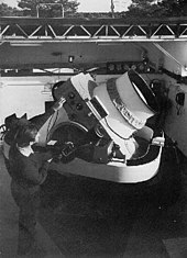
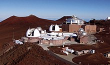
The Maui Space Surveillance Complex (MSSC) is a U.S. Space Force operating location for the 15th Space Surveillance Squadron and the Air Force Research Laboratory (AFRL) at Haleakala Observatory on Maui, Hawaii, with a twofold mission. First, it conducts the research and development mission on the Maui Space Surveillance System (MSSS) at the Maui Space Surveillance Complex (MSSC). Second, it oversees operation of the Maui High Performance Computing Center (MHPCC). AFRL's research and development mission on Maui was formally called Air Force Maui Optical Station (AMOS) and the Air Force Maui Optical and Supercomputing observatory; the use of the term AMOS has been widespread throughout the technical community for over thirty years and is still used today at many technical conferences. The main-belt asteroid 8721 AMOS is named after the project.

<span class="mw-page-title-main">Cavalier Space Force Station</span>

Cavalier Space Force Station, North Dakota, is a United States Space Force installation, where the 10th Space Warning Squadron, Space Delta 4, United States Space Force monitors and tracks potential missile launches against North America with the GE AN/FPQ-16 Enhanced Perimeter Acquisition Radar Attack Characterization System (PARCS). The PARCS also monitors and tracks over half of all earth-orbiting objects to enable space situation awareness and space control. In addition to contractors, NORAD has US and Canadian military members assigned to the facility.

<span class="mw-page-title-main">Cobra Dane</span> US radar installation for monitoring Soviet missile tests

The AN/FPS-108 COBRA DANE is a PESA phased array radar installation operated by Raytheon for the United States Space Force at Eareckson Air Station on the island of Shemya, Aleutian Islands, Alaska. The system was built in 1976 and brought online in 1977 for the primary mission of gathering intelligence about Russia's ICBM program in support of verification of the SALT II arms limitation treaty. Its single face 29 m (95 ft) diameter phased array radar antenna 52.7373°N 174.0914°E faces the Kamchatka Peninsula and Russia's Kura Test Range. COBRA DANE operates in the 1215–1400 MHz band.

<span class="mw-page-title-main">Midcourse Space Experiment</span> Space telescope

The Midcourse Space Experiment (MSX) is a Ballistic Missile Defense Organization (BMDO) satellite experiment to map bright infrared sources in space. MSX offered the first system demonstration of technology in space to identify and track ballistic missiles during their midcourse flight phase.

<span class="mw-page-title-main">20th Space Surveillance Squadron</span> U.S. Space Force unit

The 20th Space Surveillance Squadron is a Space Delta 2 unit located at Eglin Air Force Base, Florida with the mission to execute multiplatform, tactical space warfighting domain characterization, recognition, and responsiveness to achieve 21st Space Wing and United States Space Command intent. The unit, formerly designated the 20th Space Control Squadron, was renamed on 25 March 2022.

Pirinçlik Air Base, also known as Pirinçlik Air Station, formerly Diyarbakır Air Station, was a 41-year-old American-Turkish military base near Diyarbakir, Turkey. Notable base commanders include Col. Dale Lee Norman. It was known as NATO's frontier post for monitoring the former Soviet Union and the Middle East, completely closed on 30 September 1997.

<span class="mw-page-title-main">AN/FPS-17</span>

The AN/FPS-17 was a ground-based fixed-beam radar system that was installed at three locations worldwide, including Pirinçlik Air Base in south-eastern Turkey, Laredo, Texas and Shemya Island, Alaska.

<span class="mw-page-title-main">1st Space Operations Squadron</span> U.S. Space Force unit

The 1st Space Operations Squadron is a United States Space Force unit responsible for space-based space domain awareness. Located at Schriever Space Force Base, Colorado, the squadron operates the Space Based Space Surveillance system, the Advanced Technology Risk Reduction system, the Operationally Responsive Space-5 satellite, and the Geosynchronous Space Situational Awareness Program.

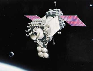
The Space Tracking and Surveillance System was a pair of satellites developed by the United States Missile Defense Agency (MDA) to research the space-based detection and tracking of ballistic missiles. Data from STSS satellites could allow interceptors to engage incoming missiles earlier in flight than would be possible with other missile detection systems. The STSS program began in 2001, when the "SBIRS Low" program was transferred to MDA from the United States Air Force. In December 2002, SBIRS Low Research & Development was renamed Space Tracking and Surveillance System (STSS).

<span class="mw-page-title-main">19th Space Operations Squadron</span> Military unit

The 19th Space Operations Squadron is an Air Force Reserve space operations unit, located at Schriever Air Force Base, Colorado.

Project Space Track was a research and development project of the US Air Force, to create a tracking system for all artificial satellites of the Earth and space probes, domestic and foreign.

Space domain awareness is the study and monitoring of satellites orbiting the Earth. It involves the detection, tracking, cataloging and identification of artificial objects, i.e. active/inactive satellites, spent rocket bodies, or fragmentation debris.

<span class="mw-page-title-main">Space Surveillance Telescope</span> Telescope for detecting orbital debris, located in Exmouth, Western Australia

The Space Surveillance Telescope (SST) is a Southern Hemisphere-based U.S. Space Force telescope used for detecting, tracking, and cataloguing satellites, near-Earth objects, and space debris.

Laredo Air Force Station was a Cold War radar station of the United States Air Force in Texas.

<span class="mw-page-title-main">Eglin AFB Site C-6</span> Transmitter/receiver building in Walton County, United States

Eglin AFB Site C-6 is a United States Space Force radar station which houses the AN/FPS-85 phased array radar, associated computer processing system(s), and radar control equipment designed and constructed for the U. S. Air Force by the Bendix Communications Division, Bendix Corporation. Commencing operations in 1969, the AN/FPS-85 was the first large phased array radar. The entire radar/computer system is located at a receiver/transmitter building and is supported by the site's power plant, fire station, 2 water wells, and other infrastructure for the system. As part of the US Space Force's Space Surveillance Network its mission is to detect and track spacecraft and other manmade objects in Earth orbit for the Combined Space Operations Center satellite catalogue. With a peak radiated power of 32 megawatts the Space Force claims it is the most powerful radar in the world, and can track a basketball-sized object up to 22,000 nautical miles (41,000 km) from Earth.

The Space Safety Programme, formerly the Space Situational Awareness (SSA) programme, is the European Space Agency's (ESA) initiative to monitor hazards from space, determine their risk, make this data available to the appropriate authorities and where possible, mitigate the threat.

Beam park is a radar mode used for space surveillance, particularly tracking space debris. In beam-park mode, a radar beam is kept in a fixed direction with respect to the Earth, while objects passing through the beam are tracked. In 24 hours, as a result of the Earth’s rotation, the radar effectively scans a narrow strip through 360° of the celestial sphere. The scattered waves are detected by a receiver and the measurements obtained during the observations can be used to determine object radar cross-section, time of peak occurrence, polarization ratio, doppler shift and object rotation. The obtained information for each object is then processed and matched against data from previously catalogued objects. The beam-park mode can be used to detect both previously known and uncatalogued objects at any altitude, provided that the reflected power captured by the receiver can be distinguished from the noise. This limits the use of radar-based beam park observations to objects in Low-Earth Orbit (LEO). Optical instruments, in turn, have very good performance for objects in Geostationary Earth Orbit (GEO) and in Geostationary Transfer Orbit (GTO). The radar technique typically outperforms optical facilities in LEO and can conduct observations for longer periods, both during day and night, independently of the weather and object illumination by sunlight.

<span class="mw-page-title-main">History of the United States Space Force</span> History of American military development

While the United States Space Force gained its independence on 20 December 2019, the history of the United States Space Force can be traced back to the beginnings of the military space program following the conclusion of the Second World War in 1945. Early military space development was begun within the United States Army Air Forces by General Henry H. Arnold, who identified space as a crucial military arena decades before the first spaceflight. Gaining its independence from the Army on 18 September 1947, the United States Air Force began development of military space and ballistic missile programs, while also competing with the United States Army and United States Navy for the space mission.

Numerica Corporation is an air and missile defense company specialized in developing innovative products and solutions used in critical defense systems worldwide.

References

  1. Charles, Charles Ira (1969). Spacetrack, Watchdog of the Skies. New York: William Morrow. p. 128. ISBN   978-0-688-31561-0.
  2. Wahl, E[berhart] W., Program Development in Orbital Computation at the U.S. National Space Surveillance Control Center. [Proceedings of the Second Symposium (International) on Rockets and Astronautics]. [Tokyo: May 1960.]
  3. 1 2 Hoots, Felix R.; Paul W. Schumacher Jr.; Robert A. Glover (2004). "History of Analytical Orbit Modeling in the U. S. Space Surveillance System". Journal of Guidance, Control, and Dynamics. 27 (2). AIAA: 174–185. Bibcode:2004JGCD...27..174H. doi:10.2514/1.9161. ISSN   0731-5090.
  4. 1 2 3 Muolo, Maj Michael J. (December 1993). Space Handbook - A War Fighter's Guide to Space (Report). Vol. One. Maxwell Air Force Base: Air University Press.
  5. Glaus, Stacy. "End of an era for AFSSS". Peterson Air Force Base. U.S. Air Force. Archived from the original on 24 March 2014. Retrieved 24 March 2014.
  6. "Good (space) fences make for good (orbital) neighbors - SpaceNews.com". SpaceNews.com. 2016-09-19. Retrieved 2017-01-01.
  7. "Space Fence · Lockheed Martin". www.lockheedmartin.com. Retrieved 2017-01-01.
  8. 1 2 3 Neal, H. L.; S.L. Coffey; S.H. Knowles (1997). "Maintaining the Space Object Catalog with Special Perturbations". Astrodynamics. v.97 (Part II). Sun Valley, ID: AAS/AIAA: 1349–1360.
  9. Vallado, David (2001). Fundamentals of Astrodynamics and Applications. Torrance: Microcosm Press. p. 958. ISBN   1-881883-12-4.
  10. Hoots, Felix R.; Ronald L. Roehrich (December 1980). "SPACETRACK REPORT NO. 3 - Models for Propagation of NORAD Element Sets". Adc/Do6. Peterson AFB: Project Spacetrack Reports, Office of Astrodynamics, Aerospace Defense Center.
  11. 1 2 3 Progress In Defense and Space, A History of the Aerospace Group of the General Electric Company, Major A. Johnson, 1993, pp262, 287-289.
  12. 1 2 A Fiery Peace in a Cold War: Bernard Schriever and the Ultimate Weapon, Neil Sheehan, 2009, pp301-311.
  13. 1 2 "The Diyarbakir Radar", Stanley G. Zabetakis & John F. Peterson, 1964. Studies in Intelligence, Fall 1964 edition, pages 41-47. Declassified.
  14. Forty Years of Research and Development at Griffiss Air Force Base, Rome Air Development Center, 1992.
  15. Streetly, Martin (2008). Jane's Radar and Electronic Warfare Systems 2008-2009. Coulsdon: Jane's Information Group. p. 670. ISBN   978-0-7106-2855-8.
  16. 1 2 NRL Memorandum Report 1637, "Information on Over-the-Horizon Radar", Part VI, 13 August 1965. Declassified.
  17. "Radar Development at Lincoln Laboratory: An Overview of the First Fifty Years", William P. Delaney and William W. Ward, Vol.12, No. 2, 2000 Lincoln Laboratory Journal, pp147-166.
  18. Johnson, N. L. (1989). "Preliminary analysis of the Fragmentation of the SPOT 1 Ariane Third Stage". Progress in Astronautics and Aeronautics. 121. Washington, DC: AIAA: 41–47.
  19. 1 2 "US Policy and Capabilities on SSA" (PDF). Secure World Foundation. 24 January 2019. Retrieved 3 October 2019.
  20. Kelso, T.S. "SATCAT Boxscore". CelesTrak. Archived from the original on July 10, 2018. Retrieved June 23, 2019.
  21. Kelso, T.S. "TLE History Statistics". CelesTrak. Retrieved June 23, 2019.
  22. "Frequently Asked Questions". Space-Track.org. Retrieved June 23, 2019. 10 centimeter diameter or "softball size" is the typical minimum size object that current sensors can track and 18 SPCS maintains in the catalog.
  23. Amy Butler (2008). "Space-Based Visible Sensor Ceases Ops". Aviation Week. Retrieved November 21, 2008.[ permanent dead link ]
  24. "Canada's DND Sapphire satellite completes commissioning". MDA. Retrieved 13 November 2014.
  25. "SSA Sharing & Orbital Data Requests". Space-Track.org. Retrieved 3 October 2019.