
The National Oceanic and Atmospheric Administration is a scientific and regulatory agency within the Washington, D.C.–based United States Department of Commerce, headquartered in Silver Spring, Maryland.

A solar flare is a relatively intense, localized emission of electromagnetic radiation in the Sun's atmosphere. Flares occur in active regions and are often, but not always, accompanied by coronal mass ejections, solar particle events, and other eruptive solar phenomena. The occurrence of solar flares varies with the 11-year solar cycle.

The Geostationary Operational Environmental Satellite (GOES), operated by the United States' National Oceanic and Atmospheric Administration (NOAA)'s National Environmental Satellite, Data, and Information Service division, supports weather forecasting, severe storm tracking, and meteorology research. Spacecraft and ground-based elements of the system work together to provide a continuous stream of environmental data. The National Weather Service (NWS) and the Meteorological Service of Canada use the GOES system for their North American weather monitoring and forecasting operations, and scientific researchers use the data to better understand land, atmosphere, ocean, and climate dynamics.

Space weather is a branch of space physics and aeronomy, or heliophysics, concerned with the varying conditions within the Solar System and its heliosphere. This includes the effects of the solar wind, especially on the Earth's magnetosphere, ionosphere, thermosphere, and exosphere. Though physically distinct, space weather is analogous to the terrestrial weather of Earth's atmosphere. The term "space weather" was first used in the 1950s and popularized in the 1990s. Later, it prompted research into "space climate", the large-scale and long-term patterns of space weather.

A geomagnetic storm, also known as a magnetic storm, is a temporary disturbance of the Earth's magnetosphere caused by a solar wind shock wave.

The National Weather Service (NWS) is an agency of the United States federal government that is tasked with providing weather forecasts, warnings of hazardous weather, and other weather-related products to organizations and the public for the purposes of protection, safety, and general information. It is a part of the National Oceanic and Atmospheric Administration (NOAA) branch of the Department of Commerce, and is headquartered in Silver Spring, Maryland, within the Washington metropolitan area. The agency was known as the United States Weather Bureau from 1890 until it adopted its current name in 1970.

The Advanced Weather Interactive Processing System (AWIPS) is a technologically advanced processing, display, and telecommunications system that is the cornerstone of the United States National Weather Service's (NWS) operations.

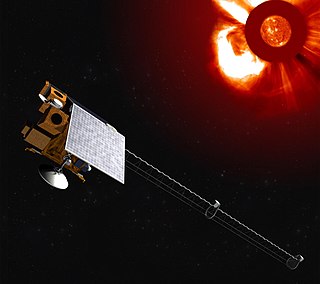
Deep Space Climate Observatory is a National Oceanic and Atmospheric Administration (NOAA) space weather, space climate, and Earth observation satellite. It was launched by SpaceX on a Falcon 9 v1.1 launch vehicle on 11 February 2015, from Cape Canaveral. This is NOAA's first operational deep space satellite and became its primary system of warning Earth in the event of solar magnetic storms.

The United States National Centers for Environmental Prediction (NCEP) delivers national and global weather, water, climate and space weather guidance, forecasts, warnings and analyses to its Partners and External User Communities. These products and services are based on a service-science legacy and respond to user needs to protect life and property, enhance that nation's economy and support the nation's growing need for environmental information. The centers form part of the National Weather Service.
Space environment is a branch of astronautics, aerospace engineering and space physics that seeks to understand and address conditions existing in space that affect the design and operation of spacecraft. A related subject, space weather, deals with dynamic processes in the solar-terrestrial system that can give rise to effects on spacecraft, but that can also affect the atmosphere, ionosphere and geomagnetic field, giving rise to several other kinds of effects on human technologies.
This is a list of meteorology topics. The terms relate to meteorology, the interdisciplinary scientific study of the atmosphere that focuses on weather processes and forecasting.
Oceanic and Atmospheric Research (OAR) is a division of the National Oceanic and Atmospheric Administration (NOAA). OAR is also referred to as NOAA Research.
The K-index quantifies disturbances in the horizontal component of Earth's magnetic field with an integer in the range 0–9 with 1 being calm and 5 or more indicating a geomagnetic storm. It is derived from the maximum fluctuations of horizontal components observed on a magnetometer during a three-hour interval. The label K comes from the German word Kennziffer meaning "characteristic digit". The K-index was introduced by Julius Bartels in 1939.

The Environmental Science Services Administration (ESSA) was a United States Federal executive agency created in 1965 as part of a reorganization of the United States Department of Commerce. Its mission was to unify and oversee the meteorological, climatological, hydrographic, and geodetic operations of the United States. It operated until 1970, when it was replaced by the new National Oceanic and Atmospheric Administration (NOAA).

Solar cycle 24 is the most recently completed solar cycle, the 24th since 1755, when extensive recording of solar sunspot activity began. It began in December 2008 with a minimum smoothed sunspot number of 2.2, and ended in December 2019. Activity was minimal until early 2010. It reached its maximum in April 2014 with a 23 months smoothed sunspot number of 81.8. This maximum value was substantially lower than other recent solar cycles, down to a level which had not been seen since cycles 12 to 15 (1878-1923).
Solar X-ray Imager (SXI) are full-disc X-ray instruments observing the Sun aboard GOES satellites. The SXI on GOES 12 was the first of its kind and allows the U.S. NOAA to better monitor and predict space weather.

The Joint Polar Satellite System (JPSS) is the latest generation of U.S. polar-orbiting, non-geosynchronous, environmental satellites. JPSS will provide the global environmental data used in numerical weather prediction models for forecasts, and scientific data used for climate monitoring. JPSS will aid in fulfilling the mission of the U.S. National Oceanic and Atmospheric Administration (NOAA), an agency of the Department of Commerce. Data and imagery obtained from the JPSS will increase timeliness and accuracy of public warnings and forecasts of climate and weather events, thus reducing the potential loss of human life and property and advancing the national economy. The JPSS is developed by the National Aeronautics and Space Administration (NASA) for the National Oceanic and Atmospheric Administration (NOAA), who is responsible for operation of JPSS. Three to five satellites are planned for the JPSS constellation of satellites. JPSS satellites will be flown, and the scientific data from JPSS will be processed, by the JPSS – Common Ground System (JPSS-CGS).

GOES-16, formerly known as GOES-R before reaching geostationary orbit, is the first of the GOES-R series of Geostationary Operational Environmental Satellites (GOES) operated by NASA and the National Oceanic and Atmospheric Administration (NOAA). GOES-16 serves as the operational geostationary weather satellite in the GOES East position at 75.2°W, providing a view centered on the Americas. GOES-16 provides high spatial and temporal resolution imagery of the Earth through 16 spectral bands at visible and infrared wavelengths using its Advanced Baseline Imager (ABI). GOES-16's Geostationary Lightning Mapper (GLM) is the first operational lightning mapper flown in geostationary orbit. The spacecraft also includes four other scientific instruments for monitoring space weather and the Sun.

Global-scale Observations of the Limb and Disk (GOLD) is a heliophysics Mission of Opportunity (MOU) for NASA's Explorers program. Led by Richard Eastes at the Laboratory for Atmospheric and Space Physics, which is located at the University of Colorado Boulder, GOLD's mission is to image the boundary between Earth and space in order to answer questions about the effects of solar and atmospheric variability of Earth's space weather. GOLD was one of 11 proposals selected, of the 42 submitted, for further study in September 2011. On 12 April 2013, NASA announced that GOLD, along with the Ionospheric Connection Explorer (ICON), had been selected for flight in 2017. GOLD, along with its commercial host satellite SES-14, launched on 25 January 2018.
Space Weather Follow On-Lagrange 1 (SWFO-L1) is a future spacecraft mission planned to monitor signs of solar storms, which may pose harm to Earth's telecommunication network. The spacecraft will be operated by the National Oceanic and Atmospheric Administration (NOAA), with launch scheduled for 31 March 2025. It is planned to be placed at the Sun–Earth L1 Lagrange point, a location between the Earth and the Sun. This will allow SWFO-L1 to continuously watch the solar wind and energetic particles heading for Earth. SWFO-L1 is an ESPA Class Spacecraft, sized for launch on an Evolved Expendable Launch Vehicle Secondary Payload Adapter (ESPA) Grande ring in addition to the rocket's primary payload. The spacecraft's Solar Wind Instrument Suite (SWIS) which includes three instruments will monitor solar wind, and the Compact Coronagraph (CCOR) will monitor the Sun's surroundings to image coronal mass ejection (CME). A CME is a large outburst of plasma sent from the Sun towards interplanetary space.
