Ocean Prediction Center

Last updated
Ocean Prediction Center
NCWCPcollegepark.jpg
Agency overview
Formed1995
Jurisdiction United States government
Headquarters College Park, MD
Agency executives
  • A.J. Reiss, Director
  • Kathy Gilbert
Website ocean.weather.gov
OPC pressure forecast valid at 48 hours Opc48hrprog.gif
OPC pressure forecast valid at 48 hours

The Ocean Prediction Center (OPC), established in 1995, is one of the National Centers for Environmental Prediction's (NCEP's) original six service centers. [1] Until 2003, the name of the organization was the Marine Prediction Center. [2] Its origins are traced back to the sinking of the RMS Titanic in 1912. The OPC issues forecasts up to five days in advance for ocean areas north of 31° north latitude and west of 35° west longitude in the Atlantic, and across the northeast Pacific north of 30° north latitude and east of 160° east longitude. Until recently, the OPC provided forecast points for tropical cyclones north of 20° north latitude and east of the 60° west longitude to the National Hurricane Center. [3] OPC is composed of two branches: the Ocean Forecast Branch and the Ocean Applications Branch.

Contents

History

The first attempt as a marine weather program within the United States was initiated in New Orleans, Louisiana, by the United States Army Signal Corps. A January 23, 1873, memo directed the New Orleans Signal Observer to transcribe meteorological data from the ship logs of those arriving in port. [4] Marine forecasting responsibility transferred from the United States Navy to the Weather Bureau in 1904, which enabled the receipt of timely observations from ships at sea. [5] The basis for OPC's mission can be traced back to the sinking of the Titanic in April 1912. In response to that tragedy, an international commission was formed to determine requirements for safer ocean voyages. In 1914, the commission's work resulted in the International Convention for the Safety of Life at Sea, of which the United States is one of the original signatories.

In 1957, in order to help address marine issues, the United States Weather Bureau started to publish the Mariners Weather Log bi-monthly publication to report past weather conditions primarily over Northern Hemisphere oceans, information regarding the globe's tropical cyclone seasons, to publish monthly climatologies for use of those at sea, and to encourage voluntary ship observations from vessels at sea. From 1957 through 1966, the United States Weather Bureau's Office of Climatology published the Log. From 1966 through the summer of 1995, the Environmental Data Service, which became the National Environmental Satellite, Data, and Information Service, published the magazine. [6]

Within the United States National Weather Service (NWS), forecast weather maps began to be published by offices in New York City, San Francisco, and Honolulu for public use. North Atlantic forecasts were shifted from a closed United States Navy endeavor to a National Weather Service product suite via radiofacsimile in 1971, while northeast Pacific forecasts became publicly available by the same method in 1972. [7] Between 1986 and 1989, [8] the portion of the National Meteorological Center (NMC) known as the Ocean Products Center (OPC) was responsible for marine weather forecasting guidance within the NWS. [9] Between August 1989 and 1995, the unit named the Marine Forecast Branch also was involved in providing objective analysis and forecast products for marine and oceanographic variables. [10] [11]

When the National Centers for Environmental Prediction was created, the Marine Prediction Center (MPC) was organized to assume the U.S. obligation to issue warnings and forecasts for portions of the North Atlantic and North Pacific oceans. MPC was expected to be moved from Camp Springs, Maryland, to Monterey, California, [1] but this did not occur. The Center was renamed the Ocean Prediction Center (OPC) on January 12, 2003. [2] [12]

Products

The National Weather Service areas of marine weather forecasting responsibility NWSmarinezones.gif
The National Weather Service areas of marine weather forecasting responsibility
Wave height analysis from OPC Opcwaveanalysis.gif
Wave height analysis from OPC

OPC's Ocean Forecast Branch issues warnings and forecasts in print and graphical formats for up five days into the future. Over 100 forecast products are issued daily. They cover the North Atlantic Ocean from the west coast of Europe to the U.S. and Canadian east coasts, and the North Pacific Ocean from the U.S. and Canadian west coast to the east coast of Asia. OPC weather forecasts and warnings for these areas primarily ensure the safety of ocean-crossing commercial ships and other vessels on the high seas. Embedded in these high seas areas are smaller offshore zones off the Atlantic and Pacific coasts. These zones extend from near the coast seaward to just beyond the U.S. Exclusive Economic Zones, out to about 250 nautical miles (460 km). OPC services ensure the safety of the extensive commercial and recreational fishing, boating, and shipping activities in these offshore waters.

OPC began to produce experimental gridded significant wave height forecasts in 2006, a first step toward digital marine service for high seas and offshore areas. Additional gridded products such as surface pressure and winds are under development. Recently, OPC began to use the NWS operational extratropical storm surge model output to provide experimental extratropical storm surge guidance for coastal weather forecast offices to assist them in coastal flood warning and forecast operations. [12]

Role in the unified surface analysis

The OPC provides an important role in the production of the National Weather Service Unified Surface Analysis. After the Weather Prediction Center, or WPC, sends out their analysis for the synoptic hour, OPC cuts and stitches the WPC analysis to its area. The National Hurricane Center, or NHC, stitches the analysis from the Honolulu Forecast Office onto their map, before it is sent up to OPC. The OPC analysts then stitch together the entire analysis, and send it to the world through their website. The analysis covers much of the Northern Hemisphere, except for eastern Europe and the western half of Asia. [13]

Quality control of marine observations

In 1994, OPC began to quality control global surface marine observations. Using an automated algorithm and interactive system, forecasters examine the latest observations from voluntary observing ships and drifting and moored platforms and compare them against short-projection model runs. Worldwide surface marine observations come to OPC via the World Meteorological Organization's Global Telecommunications System in real time. These quality control measures remove spurious data before the data are ingested into models to initialize forecasts. Several hundred of these observations are interactively examined daily. In addition, the quality controlled data are used by OPC forecasters to determine if gale, storm, or hurricane-force wind warnings are warranted. [12]

Ocean Applications Branch

The Ocean Applications Branch plays an important role in enhancing OPC operations and services. One example is the adaptation of ocean surface winds observed from the QuikSCAT satellite in early 2000. Prior to the QuikSCAT launch, there was no ability to observe, verify, and warn of hurricane-force wind conditions, areas where wind speed exceeds 64 knots (119 km/h), often associated with strong winter ocean storms. With QuikSCAT data routinely available in 2000, OPC began to issue hurricane-force wind warnings. In the 2006-2007 winter storm season, over 100 hurricane-force wind warnings were issued for North Pacific and North Atlantic oceans to warn ships of these most severe weather hazard conditions over major shipping routes. Preliminary results from a recent study estimates that in the absence of good information about extra-tropical ocean storms, the annual loss to container and dry bulk shipping would be on the order of more than $500 million. Operational marine warnings and forecasts reduce the above estimated annual loss by nearly one half.

OPC has a number of ongoing research-to-operations transition efforts that will lead to a suite of new oceanographic analysis and forecast products, such as ocean temperatures and currents based on real time observations and advanced global and basin scale ocean forecasting models. Global ocean sea surface temperatures and currents are now available on the OPC website. [12]

See also

Related Research Articles

<span class="mw-page-title-main">National Hurricane Center</span> Division of the United States National Weather Service

The National Hurricane Center (NHC) is the division of the United States' NOAA/National Weather Service responsible for tracking and predicting tropical weather systems between the Prime Meridian and the 140th meridian west poleward to the 30th parallel north in the northeast Pacific Ocean and the 31st parallel north in the northern Atlantic Ocean. The agency, which is co-located with the Miami branch of the National Weather Service, is situated on the campus of Florida International University in Westchester, Florida.

<span class="mw-page-title-main">National Weather Service</span> U.S. forecasting agency of the National Oceanic and Atmospheric Administration

The National Weather Service (NWS) is an agency of the United States federal government that is tasked with providing weather forecasts, warnings of hazardous weather, and other weather-related products to organizations and the public for the purposes of protection, safety, and general information. It is a part of the National Oceanic and Atmospheric Administration (NOAA) branch of the Department of Commerce, and is headquartered in Silver Spring, Maryland, within the Washington metropolitan area. The agency was known as the United States Weather Bureau from 1890 until it adopted its current name in 1970.

<span class="mw-page-title-main">Weather Prediction Center</span> United States weather agency

The Weather Prediction Center (WPC), located in College Park, Maryland, is one of nine service centers under the umbrella of the National Centers for Environmental Prediction (NCEP), a part of the National Weather Service (NWS), which in turn is part of the National Oceanic and Atmospheric Administration (NOAA) of the U.S. Government. Until March 5, 2013 the Weather Prediction Center was known as the Hydrometeorological Prediction Center (HPC). The Weather Prediction Center serves as a center for quantitative precipitation forecasting, medium range forecasting, and the interpretation of numerical weather prediction computer models.

<span class="mw-page-title-main">Gale warning</span> Weather forecast that includes a warning of a gale and high winds

A gale warning is an alert issued by national weather forecasting agencies around the world in an event that maritime locations currently or imminently experiencing winds of gale force on the Beaufort scale. Gale warnings allow mariners to take precautionary actions to ensure their safety at sea or to seek safe anchorage and ride out the storm on land. Though usually associated with deep low-pressure areas, winds strong enough to catalyze a gale warning can occur in other conditions too, including from anticyclones, or high-pressure systems, in the continental interior. The winds are not directly associated with a tropical cyclone.

<span class="mw-page-title-main">Index of meteorology articles</span>

This is a list of meteorology topics. The terms relate to meteorology, the interdisciplinary scientific study of the atmosphere that focuses on weather processes and forecasting.

<span class="mw-page-title-main">Severe weather terminology (United States)</span> Terminology used by the National Weather Service to describe severe weather in the US

This article describes severe weather terminology used by the National Weather Service (NWS) in the United States. The NWS, a government agency operating as an arm of the National Oceanic and Atmospheric Administration (NOAA) branch of the United States Department of Commerce (DoC), defines precise meanings for nearly all of its weather terms.

<span class="mw-page-title-main">Atlantic hurricane season</span> Tropical cyclone season

The Atlantic hurricane season is the period in a year, from June 1 through November 30, when tropical or subtropical cyclones are most likely to form in the North Atlantic Ocean. These dates, adopted by convention, encompass the period in each year when most tropical cyclogenesis occurs in the basin. Even so, subtropical or tropical cyclogenesis is possible at any time of the year, and often does occur.

<span class="mw-page-title-main">Pacific hurricane</span> Mature tropical cyclone that develops within the eastern and central Pacific Ocean

A Pacific hurricane is a tropical cyclone that develops within the northeastern and central Pacific Ocean to the east of 180°W, north of the equator. For tropical cyclone warning purposes, the northern Pacific is divided into three regions: the eastern, central, and western, while the southern Pacific is divided into 2 sections, the Australian region and the southern Pacific basin between 160°E and 120°W. Identical phenomena in the western north Pacific are called typhoons. This separation between the two basins has a practical convenience, however, as tropical cyclones rarely form in the central north Pacific due to high vertical wind shear, and few cross the dateline.

<span class="mw-page-title-main">Tropical cyclone forecast model</span> Computer program that uses meteorological data to forecast tropical cyclones

A tropical cyclone forecast model is a computer program that uses meteorological data to forecast aspects of the future state of tropical cyclones. There are three types of models: statistical, dynamical, or combined statistical-dynamic. Dynamical models utilize powerful supercomputers with sophisticated mathematical modeling software and meteorological data to calculate future weather conditions. Statistical models forecast the evolution of a tropical cyclone in a simpler manner, by extrapolating from historical datasets, and thus can be run quickly on platforms such as personal computers. Statistical-dynamical models use aspects of both types of forecasting. Four primary types of forecasts exist for tropical cyclones: track, intensity, storm surge, and rainfall. Dynamical models were not developed until the 1970s and the 1980s, with earlier efforts focused on the storm surge problem.

<span class="mw-page-title-main">Weather buoy</span> Floating instrument package which collects weather and ocean data on the worlds oceans

Weather buoys are instruments which collect weather and ocean data within the world's oceans, as well as aid during emergency response to chemical spills, legal proceedings, and engineering design. Moored buoys have been in use since 1951, while drifting buoys have been used since 1979. Moored buoys are connected with the ocean bottom using either chains, nylon, or buoyant polypropylene. With the decline of the weather ship, they have taken a more primary role in measuring conditions over the open seas since the 1970s. During the 1980s and 1990s, a network of buoys in the central and eastern tropical Pacific Ocean helped study the El Niño-Southern Oscillation. Moored weather buoys range from 1.5–12 metres (5–40 ft) in diameter, while drifting buoys are smaller, with diameters of 30–40 centimetres (12–16 in). Drifting buoys are the dominant form of weather buoy in sheer number, with 1250 located worldwide. Wind data from buoys has smaller error than that from ships. There are differences in the values of sea surface temperature measurements between the two platforms as well, relating to the depth of the measurement and whether or not the water is heated by the ship which measures the quantity.

<span class="mw-page-title-main">Tropical cyclone observation</span>

Tropical cyclone observation has been carried out over the past couple of centuries in various ways. The passage of typhoons, hurricanes, as well as other tropical cyclones have been detected by word of mouth from sailors recently coming to port or by radio transmissions from ships at sea, from sediment deposits in near shore estuaries, to the wiping out of cities near the coastline. Since World War II, advances in technology have included using planes to survey the ocean basins, satellites to monitor the world's oceans from outer space using a variety of methods, radars to monitor their progress near the coastline, and recently the introduction of unmanned aerial vehicles to penetrate storms. Recent studies have concentrated on studying hurricane impacts lying within rocks or near shore lake sediments, which are branches of a new field known as paleotempestology. This article details the various methods employed in the creation of the hurricane database, as well as reconstructions necessary for reanalysis of past storms used in projects such as the Atlantic hurricane reanalysis.

<span class="mw-page-title-main">Tropical cyclone forecasting</span> Science of forecasting how a tropical cyclone moves and its effects

Tropical cyclone forecasting is the science of forecasting where a tropical cyclone's center, and its effects, are expected to be at some point in the future. There are several elements to tropical cyclone forecasting: track forecasting, intensity forecasting, rainfall forecasting, storm surge, tornado, and seasonal forecasting. While skill is increasing in regard to track forecasting, intensity forecasting skill remains unchanged over the past several years. Seasonal forecasting began in the 1980s in the Atlantic basin and has spread into other basins in the years since.

<span class="mw-page-title-main">Tropical cyclone track forecasting</span> Predicting where a tropical cyclone is going to track over the next five days, every 6 to 12 hours

Tropical cyclone track forecasting involves predicting where a tropical cyclone is going to track over the next five days, every 6 to 12 hours. The history of tropical cyclone track forecasting has evolved from a single-station approach to a comprehensive approach which uses a variety of meteorological tools and methods to make predictions. The weather of a particular location can show signs of the approaching tropical cyclone, such as increasing swell, increasing cloudiness, falling barometric pressure, increasing tides, squalls and heavy rainfall.

<span class="mw-page-title-main">Braer Storm</span> Intense extratropical cyclone 1993 over the northern Atlantic Ocean

The Braer Storm was the most intense extratropical cyclone ever recorded over the northern Atlantic Ocean. Developing as a weak frontal wave on 8 January 1993, the system moved rapidly northeast. The combination of the absorption of a second low-pressure area to its southeast, a stronger than normal sea surface temperature differential along its path, and the presence of a strong jet stream aloft led to a rapid strengthening of the storm, with its central pressure falling to an estimated 914 hPa on 10 January. Its strength was well predicted by forecasters in the United Kingdom, and warnings were issued before the low initially developed.

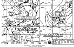
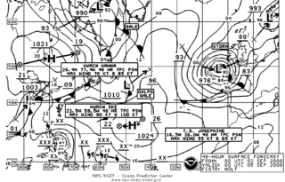
A prognostic chart is a map displaying the likely weather forecast for a future time. Such charts generated by atmospheric models as output from numerical weather prediction and contain a variety of information such as temperature, wind, precipitation and weather fronts. They can also indicate derived atmospheric fields such as vorticity, stability indices, or frontogenesis. Forecast errors need to be taken into account and can be determined either via absolute error, or by considering persistence and absolute error combined.

<span class="mw-page-title-main">Glossary of tropical cyclone terms</span>

The following is a glossary of tropical cyclone terms.

<span class="mw-page-title-main">History of Atlantic hurricane warnings</span> Aspect of meteorological history

The history of Atlantic tropical cyclone warnings details the progress of tropical cyclone warnings in the North Atlantic Ocean. The first service was set up in the 1870s from Cuba with the work of Father Benito Viñes. After his death, hurricane warning services were assumed by the US Army Signal Corps and United States Weather Bureau over the next few decades, first based in Jamaica and Cuba before shifting to Washington, D.C. The central office in Washington, which would evolve into the National Meteorological Center and the Weather Prediction Center, assumed the responsibilities by the early 20th century. This responsibility passed to regional hurricane offices in 1935, and the concept of the Atlantic hurricane season was established to keep a vigilant lookout for tropical cyclones during certain times of the year. Hurricane advisories issued every 12 hours by the regional hurricane offices began at this time.

<span class="mw-page-title-main">Marine weather forecasting</span> Forecasts of weather conditions at sea

Marine weather forecasting is the process by which mariners and meteorological organizations attempt to forecast future weather conditions over the Earth's oceans. Mariners have had rules of thumb regarding the navigation around tropical cyclones for many years, dividing a storm into halves and sailing through the normally weaker and more navigable half of their circulation. Marine weather forecasts by various weather organizations can be traced back to the sinking of the Royal Charter in 1859 and the RMS Titanic in 1912.

<i>Mariners Weather Log</i>

The Mariners Weather Log is a triannual magazine that has been published by the United States Weather Bureau, the Environmental Science Services Administration, and the National Oceanic and Atmospheric Administration since 1957. It documents significant storms over and near the Earth's oceans and the Great Lakes of North America, tropical cyclones and extratropical cyclones alike. It is also used as an outreach tool to those who sail the high seas, in order to help gain greater weather reporting from ships at sea through the voluntary observing ship program, which became increasingly important during and after the decline of the weather ship and has taken up an increasing amount of the magazine recently. Although its coverage is primarily of the Northern Hemisphere, coverage of Southern Hemisphere tropical cyclones occurred between July 1973 and 1995.

<span class="mw-page-title-main">Hurricane Genevieve (2014)</span> Pacific hurricane and typhoon in 2014

Hurricane Genevieve, also referred to as Typhoon Genevieve, was the first tropical cyclone to track across all three northern Pacific basins since Hurricane Dora in 1999. Genevieve developed from a tropical wave into the eighth tropical storm of the 2014 Pacific hurricane season well east-southeast of Hawaii on July 25. However, increased vertical wind shear caused it to weaken into a tropical depression by the following day and degenerate into a remnant low on July 28. Late on July 29, the system regenerated into a tropical depression, but it weakened into a remnant low again on July 31, owing to vertical wind shear and dry air.

References

  1. 1 2 Stephanie Kenitzer (1995-05-18). "NOAA Creates National Centers for Environmental Prediction". National Oceanic and Atmospheric Administration. Archived from the original on 2008-09-16. Retrieved 2008-09-03.
  2. 1 2 Ocean Prediction Center (2004). Ocean Prediction Center: 2003 Accomplishments. Archived 2016-06-02 at the Wayback Machine Retrieved on 2008-09-03.
  3. Staff Writer, Ocean Prediction Center (2005-01-05). "Vision & Mission Statement". National Weather Service. Archived from the original on 2012-09-24. Retrieved 2008-09-03.
  4. Elwyn E. Wilson, ed. (March 1973). "Historic Letter Establishing Marine Program at New Orleans". Mariners Weather Log . National Oceanic and Atmospheric Administration. 17 (2): 85.
  5. Kristine C. Harper (2008). "Weather By the Numbers: The Genesis of Modern Meteorology" (PDF). The Massachusetts Institute of Technology Press. p. 18. ISBN   978-0-262-08378-2.[ permanent dead link ]
  6. Martin S. Baron (April 1998). "From the Editorial Supervisor". Mariners Weather Log. National Oceanic and Atmospheric Administration. 42 (1): 3.
  7. World Meteorological Organization (March 1972). "Radiofacsimile Transmission of Weather Charts For Ships". Mariners Weather Log . National Oceanic and Atmospheric Administration. 16 (2): 71–76.
  8. Yung Y. Chao and Tina L. Bertucci (October 1989). "Office Note 361: A Columbia River Entrance Wave Forecasting Program Development at the Ocean Products Center" (PDF). National Meteorological Center. p. iii.
  9. National Research Council (1989). Opportunities to Improve Marine Weather Forecasting. National Academy Press. p. 6. ISBN   0-309-04090-6 . Retrieved 2013-04-12.
  10. Vera M. Gerald (August 1989). "OPC Unified Marine Database Verification System" (PDF). National Meteorological Center. p. 1.
  11. Glen Paine (Fall 1995). "Heavy Weather Avoidance: A Mariners Perspective Part 2". Mariners Weather Log. National Oceanic and Atmospheric Administration. 39 (4): 18.
  12. 1 2 3 4 David Feit (2008-06-19). "Ocean Prediction Center: Overview". Ocean Prediction Center. Archived from the original on 2008-09-09. Retrieved 2008-09-03.
  13. "Unified Surface Analysis Manual" (pdf). Hydrometeorological Prediction Center. 2006-12-14. Retrieved 2008-09-03.