Climate of Pakistan

Last updated
Pakistan map of Koppen climate classification (note that the humid subtropical climate - in green, has expanded southward, and that a semi arid climate has emerged in the southeast (Sindh)). Koppen-Geiger Map PAK present.svg
Pakistan map of Köppen climate classification (note that the humid subtropical climate - in green, has expanded southward, and that a semi arid climate has emerged in the southeast (Sindh)).

Pakistan's climate varies from a continental type of climate in the north (Kashmir, KPK), a mountainous dry climate in the west (Baluchistan), a wet climate in the East (Punjab) an arid climate in the Thar Desert, to a tropical climate in the southeast (Sindh), characterized by extreme variations in temperature, both seasonally and daily, because it is located on a great landmass barely north of the Tropic of Cancer (between latitudes 25° and 37° N).

Contents

Very high altitudes modify the climate in the cold, snow-covered northern mountains; temperatures on the Balochistan plateau are somewhat higher. Along the coastal strip, the climate is modified by sea breeze. In the rest of the country, temperatures reach great heights in the summer; the mean temperature during June is 38 °C (100 °F) in the plains, the highest temperatures can exceed 53 °C (127 °F). During summer, hot winds called Loo blow across the plains during the day. Trees shed their leaves to avoid loss of moisture. Pakistan recorded one of the highest temperatures in the world, 53.7 °C (128.66 °F) on 28 May 2017, the hottest temperature ever recorded in Pakistan and also the second hottest measured temperature ever recorded in Asia. [1]

The dry, hot weather is broken occasionally by dust storms and thunderstorms that temporarily lower the temperature. Evenings are cool; the daily variation in temperature may be as much as 11 °C to 17 °C. Winters are cold, with minimum mean temperatures in Punjab of about 4 °C (39 °F) in January, and sub-zero temperatures in the far north and Balochistan.

Winters are extremely cold in the north and the milder they get the more you go to the south.Spring causes heavy rainfall in the northern parts while it is mild in most parts of pakistan.Summers are sweltering,boiling and extremely hot in southern punjab and upper sindh while it gets milder the more you go to the north and the coast.The Monsoon season(late june-late spetember) also occurs in the summer season. Autumn is pleasent but gets cooler day by day with almost no rainfall.Winter in some parts even starts in late October-early November.

Climate geography

Estimation of regions where snow regularly falls Regions where Snow Falls in Pakistan.png
Estimation of regions where snow regularly falls

The monsoon and the Western Disturbance are the two main factors which alter the weather over Pakistan; Continental air prevails for the rest of the year. Following are the main factors that influence the weather over Pakistan.

Pakistan has four seasons: a cool and cold winter from December through February; a pleasant spring from March through May; the summer rainy season, or southwest monsoon period, from June through September; and dry autumn period of October and November. The onset and duration of these seasons vary greatly according to location.

The climate in the capital city of Islamabad varies from an average daily low of 2 °C in January to an average daily high of 38 °C in June. Half of the annual rainfall occurs in July and August, averaging about 255 millimeters in each of those two months. The remainder of the year has significantly less rain, amounting to about fifty millimeters per month. Hailstorms are common in the spring.

Pakistan's largest city, Karachi, which is also the country's industrial center, is more humid than Islamabad but gets less rain, but still possesses a tropical climate. Only June, July, August and September average more than 70 millimeters of rain in the Karachi area; the remaining months are rather dry. The temperature is also more uniform in Karachi than in Islamabad, due to its tropical climate, ranging from an average daily low of 13 °C during winter evenings to an average daily high of 34 °C on summer days. Although the summer temperatures do not get as high as those in Punjab, the high humidity causes the residents a great deal of discomfort. In Islamabad, there are cold winds from the north of Pakistan. [3]

A high of 53.7 °C (128.66 °F) was recorded in Turbat, Balochistan on 28 May 2017. It was not only the hottest temperature ever recorded in Pakistan but also the second verified hottest temperature ever recorded in Asia [1] and the fourth highest temperature ever recorded on earth. The highest rainfall of 620 millimetres (24 in) was recorded in Islamabad during 24 hours on 24 July 2001. The record-breaking rain fell in just 10 hours. It was the heaviest rainfall in Islamabad in the previous 100 years.

Tropical cyclones and tornadoes

Each year before the onset of monsoon that is 15 April to 15 July and also after its withdrawal that is 15 September to 15 December, there is always a distinct possibility of the cyclonic storm to develop in the north Arabian Sea. Cyclones form in the Arabian sea often results in strong winds and heavy rainfall in Pakistan's coastal areas. However tornadoes mostly occur during spring season that is March and April usually when a Western Disturbance starts effecting the northern parts of the country. It is also speculated that cycles of tornado years may be correlated to the periods of reduced tropical cyclone activity.

Drought

Drought in Balochistan, Pakistan Dried Up Dam Water, Mirani Dam Turbat region, Balochistan.jpg
Drought in Balochistan, Pakistan
Pakistan is the fifteenth most water stressed country in the world. Water Stress, Top Countries (2020).svg
Pakistan is the fifteenth most water stressed country in the world.

The drought has become a frequent phenomenon in the country. Already, the massive droughts of 1998-2002 has stretched the coping abilities of the existing systems to the limit and it has barely been able to check the situation from becoming a catastrophe. The drought of 1998-2002 is considered the worst drought in 50 years. According to the Economic Survey of Pakistan, the drought was one of the most significant factors responsible for the less than anticipated growth performance. The survey terms it as the worst drought in the history of the country. According to the government, 40 percent of the country's water needs went unmet. [4] [5]

Floods

Pakistan has seen many floods, the worst and most destructive is the recent 2010 Pakistan floods, other floods which caused destruction in the history of Pakistan, include the flood of 1950, which killed 2910 people; on 1 July 1977 heavy rains and flooding in Karachi, killed 248 people, according to Pakistan meteorological department 207 millimetres (8.1 in) of rain fell in 24 hours. [6] In 1992 flooding during Monsoon season killed 1,834 people across the country[ citation needed ]. In 1993 flooding during Monsoon rains killed 3,083 people over South Asia, 15 of whom were in Pakistan. [7] In 2003 Sindh province was badly affected due to monsoon rains causing damages in billions, killed 178 people, while in 2007 Cyclone Yemyin submerged lower part of Balochistan Province in sea water killing 380 people. Before that it killed 213 people in Karachi on its way to Balochistan.

2010 Floods

2010 July floods swept 20% of Pakistan's land, the flood is the result of unprecedented Monsoon rains which lasted from 28 July to 31 July 2010. Khyber Pakhtunkhwa and North eastern Punjab were badly affected during the monsoon rains when dams, rivers and lakes overflowed. By mid-August, according to the governmental Federal Flood Commission (FFC), the floods had caused the deaths of at least 1,540 people, while 2,088 people had received injuries, 557,226 houses had been destroyed, and over 6 million people had been displaced. [8] One month later, the data had been updated to reveal 1,781 deaths, 2,966 people with injuries, and more than 1.89 million homes destroyed. [9] The flood affected more than 20 million people exceeding the combined total of individuals affected by the 2004 Indian Ocean tsunami, the 2005 Kashmir earthquake and the 2010 Haiti earthquake. [10] [11] The flood is considered as worst in Pakistan's history affecting people of all four provinces and Gilgit–Baltistan and Azad Kashmir region of Pakistan. [12]

2011 Sindh floods

The 2011 Sindh floods began during the monsoon season in mid-August 2011, resulting from heavy monsoon rains in Sindh, Eastern Balochistan, and Southern Punjab. [13] The floods have caused considerable damage; an estimated 270 civilians have been killed, with 5.3 million people and 1.2 million homes affected. [14] Sindh is a fertile region and often called the "breadbasket" of the country; the damage and toll of the floods on the local agrarian economy is said to be extensive. At least 1.7 million acres of arable land has been inundated as a result of the flooding. [14] The flooding has been described as the worst since the 2010 Pakistan floods, which devastated the entire country. [14] Unprecedented torrential monsoon rains caused severe flooding in 16 districts of Sindh province. [15]

2022 floods

In 2022, floods caused by monsoon rains and melting glaciers in Pakistan particularly in the southern regions of Sindh and Balochistan had killed at least 1,128 people, including 340 children and six military officers in a helicopter crash, with over 1,700 more injured. It is the world's deadliest flood since 2017. [16] On 25 August, Pakistan declared a state of emergency because of the flooding. [17]

2023 floods

From March to July of 2023, floods caused by monsoon rains returned to Pakistan after nine months. They worsened at the end of June due to upcoming monsoon rains. [18] At least 159 people were killed, including many children. [18]

Extreme temperatures

Climate data for Pakistan
MonthJanFebMarAprMayJunJulAugSepOctNovDecYear
Record high °C (°F)43.4
(110.1)
44.0
(111.2)
48.9
(120.0)
54.2
(129.6)
55
(131)
66.6
(151.9)
56.7
(134.1)
55.9
(132.6)
57.0
(134.6)
52.0
(125.6)
48.0
(118.4)
47.3
(117.1)
66.6
(151.9)
Record low °C (°F)−2.3
(27.9)
2.8
(37.0)
15.5
(59.9)
15.5
(59.9)
19.3
(66.7)
23.0
(73.4)
19.7
(67.5)
20.3
(68.5)
20.0
(68.0)
17.0
(62.6)
9.0
(48.2)
−5.6
(22.0)
−5.6
(22.0)
[ citation needed ]

Climate change

Climate change may have been a contributing factor to the severity of the 2010 Pakistan floods. Pakistan flood damage 2010.jpg
Climate change may have been a contributing factor to the severity of the 2010 Pakistan floods.
Climate change in Pakistan is a major issue for the country. Pakistan is highly vulnerable to climate change. As with the changing climate in South Asia as a whole, the climate of Pakistan has changed over the past several decades, with significant impacts on the environment and people. [19] In addition to increased heat, drought and extreme weather in parts of the country, the melting of glaciers in the Himalayas has impacted some of the important rivers of Pakistan. Between 1999 and 2018, Pakistan ranked 5th in the countries affected by extreme weather caused by climate change. [20] Pakistan is prone to a range of natural disasters, including cyclones, floods, drought, intense rainfall, and earthquakes. According to scientific research, climate change played a substantial role in the devastating floods of 2022, which had a direct impact on over 30 million people in Pakistan, resulting in the loss of lives, damage to public infrastructure, and displacement from homes. [21] Climate change poses a significant menace to Pakistan's economy and security. [22]

See also

Related Research Articles

<span class="mw-page-title-main">Geography of Pakistan</span>

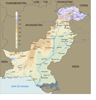
The Geography of Pakistan encompasses a wide variety of landscapes varying from plains to deserts, forests, and plateaus ranging from the coastal areas of the Indian Ocean in the south to the mountains of the Karakoram, Hindukush, Himalayas ranges in the north. Pakistan geologically overlaps both with the Indian and the Eurasian tectonic plates where its Sindh and Punjab provinces lie on the north-western corner of the Indian plate while Balochistan and most of Khyber Pakhtunkhwa lie within the Eurasian plate which mainly comprises the Iranian Plateau.

<span class="mw-page-title-main">Climate of India</span> Overview of climatic conditions in India

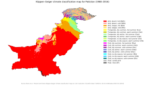
The climate of India consists of a wide range of weather conditions across a vast geographic scale and varied topography. Based on the Köppen system, India hosts six major climatic sub types, ranging from arid deserts in the west, alpine tundra and glaciers in the north, and humid tropical regions supporting rain forests in the southwest and the island territories. Many regions have starkly different microclimates, making it one of the most climatically diverse countries in the world. The country's meteorological department follows the international standard of four seasons with some local adjustments: winter, summer, monsoon or rainy season, and a post-monsoon period.

Karachi has a semi-arid climate, formerly a hot desert climate, albeit a moderate version of this climate, influenced by monsoons. Karachi has a tropical climate, despite being located slightly above the Tropic of Cancer. It is situated in the monsoon region of Pakistan. It is located on the coast bordering the Arabian Sea, and as a result, has a relatively mild climate. However, in more recent years, rainfall has become more abundant. For this reason, the city may be classed as semi-arid (BSh), since it has a mild climate with a short but defined wet season, along with a lengthy dry season.

The province of Sindh is situated in a tropical region, with subtropical regions in the northern sections; it is hot, humid and very rainy in the summer and cold and dry in winter. Temperatures frequently rise above 46 °C (115 °F) between May and August, and the minimum average temperature of 2 °C (36 °F) occurs during December and January. The annual rainfall averages about nearly 13 inches (330 mm), falling mainly during June and September. The southwesterly monsoon wind begins to blow in mid-February and continues until the end of September, whereas the cool northerly wind blows during the winter months from October to January.

The climate of Islamabad is a humid subtropical climate with four seasons: a pleasant Spring (March–April), a hot Summer (May–August), a warm dry Autumn (September—October), and a cold Winter (November—February). The hottest month is June, where average highs routinely exceed 37 °C (98.6 °F). The wettest month is July, with heavy rainfall and evening thunderstorms with the possibility of cloudburst. The coldest month is January, with temperatures variable by location. In Islamabad, temperatures vary from cold to mild, routinely dropping below zero. In the hills there is sparse snowfall. The weather ranges from a minimum of −6.0 °C (21.2 °F) in January to a maximum of 46.1 °C (115.0 °F) in June. The average low is 2 °C (35.6 °F) in January, while the average high is 38.1 °C (100.6 °F) in June. The highest temperature recorded was 46.5 °C (115.7 °F) in June, while the lowest temperature was −6.0 °C (21.2 °F) in January. On 23 July 2001, Islamabad received a record breaking 620 millimetres (24 in) of rainfall in just 10 hours. It was the heaviest rainfall in Pakistan during the past 100 years.

<span class="mw-page-title-main">Cyclone Phet</span> North Indian cyclone in 2010

Very Severe Cyclonic Storm Phet was a powerful tropical cyclone that made landfall on Oman, Western India, and Pakistan. The third named cyclone of the 2010 cyclone season, Phet developed in the Arabian Sea on May 31 to the west of India. With conducive environmental conditions, the storm intensified to reach peak sustained winds of 155 km/h (95 mph) on June 2, based on analysis by the India Meteorological Department (IMD). On the next day, Phet dropped heavy rainfall while moving across eastern Oman, with a peak of 603 mm (23.7 in) in Qurayyat. The rains flooded arid areas and collected into wadis – normally dry river beds. Thousands of homes were wrecked across Oman. There were 24 fatalities in the country, and damage was estimated at US$780 million.

Quetta, Pakistan features a continental semi-arid climate with a large variation between summer and winter temperatures. The highest temperature recorded in Quetta was 42 °C (108 °F) on 10 July 1998. The lowest temperature in Quetta is −18.3 °C (−0.9 °F) which was recorded on 8 January 1970.

Multan is a city located in the southern part of Punjab, province in Pakistan. Multan features a hot semi arid climate with very hot and rainy summers and cold winters. The city witnesses some of the most extreme temperatures in the country. Dust storms are a common occurrence within the city. The closest major city is Bahawalpur. The area around the city is a flat plain and is ideal for agriculture, with many citrus and mango farms. There are many canals that cut across the Multan District, providing water from nearby farms. This makes the land very fertile. However usually land close to the Chenab River are flooded in the monsoon season.

The climate of Hyderabad is semi-arid, featuring too little rain to feature the tropical savanna climate. The days are hot and dry, usually going up to extreme highs of 40 °C (104 °F), while the nights are cool and breezy. Winds usually bring along clouds of dust, and people prefer staying indoors in the daytime, while the breezes at night are pleasant and clean.

<span class="mw-page-title-main">2011 Sindh floods</span>

The 2011 Sindh floods was the highest-ever recorded rainfall between 11 August 2011, and 14 September 2011 in Sindh Province, Pakistan.

The 2012 Pakistan floods began in early September 2012, resulting from heavy monsoon rains in Khyber Pakhtunkhwa, Upper Sindh, Southern Punjab and Balochistan regions of Pakistan.

Rawalpindi features a humid subtropical climate with hot summers, and cool to cold winters. Its climate is classified as very similar to its twin city Islamabad, but the geographical location and extreme urbanization of Rawalpindi has led to weather and climatic conditions that are notably different from its twin. Rawalpindi's weather has historically been known to change rather quickly due to its proximity to Himalayas and the Pir Panjal Range. These mountains not only influence the weather of the city, but also provide great recreation during the hot months. Furthermore, Its warm comfortable mean annual temperature of 21.3 °C (70 °F) attracts people to live here permanently from all over Pakistan. The average annual rainfall is abundant at 1,346.8 millimetres (53.02 in), most of which falls in the monsoon season. However, frontal cloud bands also bring significant rainfall in the winter. In summers, June is the hottest with record maximum temperature at a blistering 48.3 °C (119 °F) recorded on 13 June 1953. On the other hand, January is the coldest month of the year when temperature can drop to a minimum −3.9 °C (25 °F) in the winter recorded on 17 January 1967. Throughout the year, Rawalpindi and Islamabad experience an average of about 98 thunderstorms, which is the highest frequency of thunderstorms in Punjab province of any plane station. In fact, most rainfall in the city is accompanied by a thunderstorm with peak activity experienced in August. Record rainfall was experienced in the year 2013 at a massive 1,988 millimetres (78.3 in) mostly due to an unusually wet monsoon season. On a typical day, the city hosts breezy afternoons, but usually calm to light breeze wind conditions are observed after midnight. The mean annual wind speed of Rawalpindi is roughly 10 kilometres per hour (6.2 mph) at 14 m height. Moreover, just a few kilometers southwest of Rawalpindi, the potential power generation has been identified by U.S. Aid to be between marginal to good at 50 m height.

From February to April 2019, widespread flash flooding affected large parts of Pakistan, most severely in Balochistan, KPK, Punjab, and other provinces. Pakistan has been hit by three major waves of rain and flooding over the course of more than one month. The first wave of rain began on 20 February, leading to flooding in to Khyber and Balochistan, therefore many villages and several cities have been evacuated, and more than 1,500 families has been rescued alone in Balochistan and many in other states. The 20 February rain and thunderstorms caused flash floods in the Lasbela area. The main areas affected were Turbat, Tump, Nasirabad and Dasht where 300 people were displaced due to the flood. These people were then moved to camps established by the Provincial Disaster Management Authority (PDMA). Casualties have came mostly due to roof collapsing amid heavy rains and flash flooding. Khyber Pakhtunwkha has witnessed the most deaths till now, 40, alongside Balochsitan has faced 26 casualties with more than 9 in Punjab and other places. Due to rain, flood and storm casualties are increasing.

The 2020 Karachi floods were the worst flooding Karachi had seen in almost a century, and killed at least 41 people across Pakistan. The floods were caused by record monsoon rains, which were inadequately drained by poorly maintained drainage systems in the city. The resulting floods caused deaths and destruction of infrastructure and properties in the city.

<span class="mw-page-title-main">2016 Pakistan Floods</span> Natural disaster in Pakistan

In 2016 Pakistan experienced higher rainfall than normal (10-20%), especially in the pre-monsoon season. Heavy monsoon rains are common in the region. This led to multiple periods of flooding, landslides, and damage particularly in Northern Pakistan. The Swat River overflowed and multiple landslides occurred around Pakistan including in Khyber Pakhtunkhwa, Gilgit-Baltistan, Azad Jammu, and Kashmir.

<span class="mw-page-title-main">2022 South Asian floods</span>

From January to October 2022, excessive rainfall and widespread monsoon flooding occurred in the South Asian countries of Afghanistan, Bangladesh, India, Nepal, Pakistan, and Sri Lanka. It has become the region's deadliest floods since 2020, with over 3,700 people dead.

The 2023 Pakistan floods occurred from March to July of 2023, caused by monsoon rains which returned to Pakistan after nine months after the 2022 Pakistan floods. Floods worsened at the end of June due to upcoming monsoon rains. At least 159 people were killed, including many children.

References

  1. 1 2 "WMO verifies 3rd and 4th hottest temperature recorded on Earth". World Meteorological Organization. 18 June 2019. Archived from the original on 18 December 2023. Retrieved 8 May 2020.
  2. "History of Dust Storm in Karachi". pakistanweatherportal.com. 6 June 2021. Retrieved 7 April 2022.
  3. "Pakistan - Climate". countrystudies.us. Retrieved 7 April 2018.
  4. "Archived copy" (PDF). Archived from the original (PDF) on 9 July 2011. Retrieved 1 June 2010.{{cite web}}: CS1 maint: archived copy as title (link)
  5. Platform, International Recovery. "Sorry, there has been a problem - 'assets/publication/9+sept/Drought/drought+coping+in+afghanistan.pdf' cannot be found - International Recovery Platform" (PDF). www.recoveryplatform.org. Retrieved 7 April 2018.
  6. "Dawn.com: Heavy Rain in Karachi". Dawn.com. 27 July 2002. Retrieved 6 September 2010.
  7. "1993 Global Register of Extreme Flood Events". Archived from the original on 18 October 2003.
  8. Ahmadani A (19 August 2010). "Heavily Funded FFC Fails to Deliver". TheNation. Archived from the original on 6 July 2011. Retrieved 17 October 2010.
  9. Singapore Red Cross (15 September 2010). "Pakistan Floods:The Deluge of Disaster - Facts & Figures as of 15 September 2010" . Retrieved 18 October 2010.
  10. South Asia, BBC News (14 August 2010). "Floods affect 20m people – Pakistan PM Gilani". British Broadcasting Corporation. Retrieved 14 August 2010.
  11. "Floods in Pakistan worse than tsunami, Haiti". gulfnews. Retrieved 12 August 2010.
  12. "Dawn.com : 2010 Pakistan Floods". Dawn.com. Retrieved 6 September 2010.
  13. "Pakistan floods: Oxfam launches emergency aid response". BBC World News South Asia. 14 September 2011. Retrieved 15 September 2011.
  14. 1 2 3 "Floods worsen, 270 killed: officials". The Express Tribune. 13 September 2011. Retrieved 13 September 2011.
  15. "Government of Pakistan". Archived from the original on 24 April 2012. Retrieved 26 December 2010.
  16. "worst rains and floods; 1128 people dead, more than 4 crore people homeless – Pakistan". Hoshyar Pakistan. 27 August 2022.
  17. Abbas, Zaki (26 August 2022). "Pakistan declares emergency in the face of calamitous floods".
  18. 1 2 "2 weeks of monsoon rains in Pakistan have killed at least 55, including 8 children". Associated Press. 6 July 2023. Retrieved 7 July 2023.
  19. "World Bank Climate Change Knowledge Portal". climateknowledgeportal.worldbank.org. Retrieved 29 October 2023.
  20. Eckstein, David, et al. "Global climate risk index 2020." (PDF) Germanwatch (2019).
  21. Hansberry, Cate (15 September 2023). "Empowering Pakistan's youth to address climate change risks". Atlantic Council. Retrieved 6 October 2023.
  22. Hansberry, Cate (15 September 2023). "Empowering Pakistan's youth to address climate change risks". Atlantic Council. Retrieved 30 October 2023.