List of mountains in Pakistan

Last updated

Nanga Parbat, the 9th highest in the world Nanga Parbat The Killer Mountain.jpg
Nanga Parbat, the 9th highest in the world

Pakistan is home to 108 peaks above 7,000 metres and 4555 above 6,000 m. There is no count of the peaks above 5,000 and 4,000 m. Five of the 14 highest independent peaks in the world (the eight-thousanders) are in Pakistan (four of which lie in the surroundings of Concordia; the confluence of Baltoro Glacier and Godwin Austen Glacier). Most of the highest peaks in Pakistan lie in the Karakoram mountain range (which lies almost entirely in the Gilgit–Baltistan region of Pakistan, and is considered to be a separate range from Himalayan range) but some peaks above 7,000 m are included in the Himalayan and Hindu Kush ranges. Moreover, Pakistan is home to over 7,000 glaciers, more than anywhere except the polar regions. [1]

Contents

Considerations

The list is an incomplete list of mountains in Pakistan. There are many named and unnamed peaks in Pakistan that are currently not included in this list. The list also includes many peaks that are not usually classed as independent mountains, but instead are considered sub-peaks of other mountains, due to having low topographic prominence (the height of a peak above the highest saddle connecting it to a higher summit). Also, many of the elevations listed are approximate, due to imprecise and inconsistent surveys. The ranks in the peaks above 7,000 metres (23,000 ft) are derived from the list of highest mountains.

The dividing line between a mountain with multiple peaks and separate mountains is not always clear (see Highest unclimbed mountain). A common threshold is to define a mountain as a summit with 300 m prominence (1,000 ft; also 10 traditional rope lengths). Alternatively, a relative prominence (prominence or height) is used (usually 7–8%) to reflect that in higher mountain ranges everything is on a larger scale. The list of highest mountains ranks the highest 100 summits with at least 500 m prominence, approximating a 7% relative prominence. A drawback of a prominence-based list is that it may exclude peaks commonly thought of as mountains that are connected via a high ridge to a taller summit. Many such peaks and mountains with less than sufficient prominence are included but not numbered in the list.

It is very unlikely that all the heights given are correct to the nearest meter; indeed, problems of definition of sea level can arise when a mountain is remote from the sea. Different sources often differ by many meters, and many mountains in the Karakorum differ by over 100 metres on different maps. These discrepancies serve to emphasise the uncertainties in the listed heights.

Geographical distribution

Most of the highest mountains in Pakistan are located in the Karakoram range, some high mountains are in Himalaya (the highest of which is Nanga Parbat, globally ranked 9th, 8126 m) and Hindu Kush (the highest of which is Tirich Mir, globally ranked 33rd, 7708 m).

The locations of the highest mountains are shown on the composite satellite image of Karakoram and Hindu Kush below. The numbers refer to the global ranking in this "List of highest mountains". For clarity, lower peaks with labels overlapping higher peaks are left out of the main image.

Location of peaks in Hindu Kush and Karakoram, ranked globally as in the list Hindu Kush and Karakoram peaks annotated (NASA satellite Terra MODIS).png
Location of peaks in Hindu Kush and Karakoram, ranked globally as in the list

Most of the high peaks in Pakistan lie specifically in Gilgit–Baltistan with the exception of a few 7,000+ m peaks in the high Hindu Kush (the peaks marked in the northwest most region of Pakistan).

The peak marked as number 9 is Nanga Parbat (8,125 m), which is the 2nd highest Himalayan peak in Pakistan. All other peaks above 8,000m are in the Baltoro Muztagh subrange of Karakoram.

8000+ meters

World RankRank (Pakistan)NameHeight (m)Location
21 Godwin Austen-K2 8611 Karakoram
92 Nanga Parbat 8126 Himalaya
113 Gasherbrum I (K5)8080 Karakoram
124 Broad Peak 8051 Karakoram
135 Gasherbrum II (K4)8035 Karakoram

7000 to 8000 meters

World RankRank (Pakistan)NameHeight (m)LocationSub-Range
Gasherbrum III (K3a)7952 Karakoram Baltoro Muztagh
176 Gasherbrum IV (K3)7925
197 Distaghil Sar 7885 Shimshal
218 Kunyang Chhish 7852 Shimshal
229 Masherbrum (K1)7821 Masherbrum Mountains
2510 Batura I 7795 Batura Muztagh
2611 Kanjut Sar 7790 Shimshal
2712 Rakaposhi 7788 Rakaposhi-Haramosh Mountains
Batura II 7762 Batura Muztagh
31 Saltoro Kangri 7742 Saltoro Mountains
Batura III 7729 Batura Muztagh
3313 Tirich Mir 7708 Hindu Kush
3614 Chogolisa I 7665 Karakoram Masherbrum u
3815 Shispare 7611 Batura Muztagh
Silberzacken 7597 Himalaya Nanga Parbat
Batura IV 7594 Karakoram Batura Muztagh
Unnamed7581
3916 Trivor 7577 Shimshal
4417 Skyang Kangri 7,545 Baltoro Muztagh
4418 Yukshin Gardan Sar 7530 Shimshal
5219 Noshaq 7492 Hindu Kush
5320 Pumari Chhish (W)7492 Karakoram Shimshal
5421 Passu Sar 7476 Batura Muztagh
5822 Malubiting (W)7458 Rakaposhi-Haramosh Mountains
6124 K12 7428 Saltoro Mountains
Muchu Chhish 7453 Batura Muztagh
6325 Sia Kangri 7422 Baltoro Muztagh
6426 Momhil Sar 7343 Shimshal
6627 Skil Brum 7420 Baltoro Muztagh
6728 Haramosh 7409 Rakaposhi-Haramosh Mountains
6829 Istor-o-nal 7403 Hindu Kush
6930 Ghent Kangri 7400 Karakoram Saltoro Mountains
7031 Ultar Sar 7388 Batura Muztagh
7433 Sherpi Kangri 7380 Saltoro Mountains
7834 Saraghrar 7349 Hindu Kush
8135 Chongtar 7315 Karakoram Baltoro Muztagh
8236 Baltoro Kangri 7280 Masherbrum Mountains
8837 Yutmaru Sar 7,283 Hispar
Jutmo Sar 7330
Bojohagur Duanasir I 7329 Batura Muztagh
Yazghil 7324 Shimshal
Unnamed7300
Passu Diar 7295 Batura Muztagh
Unnamed7295
Malubiting C 7291
8738 Baintha Brakk (The Ogre)7285 Panmah Muztagh
8940 Baltistan Peak (K6)7282 Masherbrum Mountains
Unnamed7280
9141 Muztagh Tower 7273 Baltoro Muztagh
9342 Diran 7266 Rakaposhi-Bagrote Mountains
10443 Malungutti Sar (Mulungutti)7207 Shimshal
10944 Lupghar Sar (Central)7200 Shimshal
Hachindar Chhish 7163 Karakoram
Snow Dome 7160 Baltoro Muztagh
Praqpa Ri7156Baltoro Muztagh
Latok I 7151 Panmah Muztagh
Gasherbrum V 7147 Baltoro Muztagh
Latok II 7145 Panmah Muztagh
Kampire Dior 7143 Batura Muztagh
Unnamed7133 Baltoro Muztagh
Kunyang Chhish N 7108 Hispar Muztagh
Udren Zom 7108 Hindu Kush
Ghenta Peak 7090 Batura Muztagh
Rakhiot Peak 7070 Himalaya Nanga Parbat Group
Sangemarmar Sar 7050 Karakoram Batura Muztagh
Link Sar 7041 Masherbrum Mountains
Spantik (Golden Peak)7027 Spantik-Sosbun Mountains
Akher Chhish 7020 Hindu Kush
Pamiri Sar 7016 Karakoram
Rakaposhi East 7010
Mohsin Mir 7004 Baltoro Muztagh

6000 to 7000 meters

NameHeight (m)Location
Laila Peak 6986 Karakom Haramosh Valley, Chogurunma Glacier
Karun Kuh 6977 Shimshal
K7 6934 Hushe Valley
Beka Brakai Chhok 6882
Vigne Peak 6874
Koyo Zom 6871 Hindu Raj Pechus Glacier
Dut Sar 6858 Karakoram Shimshal
Angel Sar 6858 K2 and Concordia
Latok III 6850
Chongra Peak 6830 Himalaya Nanga Parbat
Miar Peak 6824 Karakoram
Rhuparash 6785
Biarchedi 6781 Baltoro Glacier
Seiri Porkush 6771 Batura Glacier
Choricho 6756
Biale Peak 6729
Trinity Peak 6700
Mani Peak 6685
Haramosh II 6666
Thui I 6660 Hindu Raj Ponarillo Glacier
Gul Lasht Zom 6657 Lutkho Valley
Piaju Peak 6610 Karakoram
Makrong Chhish 6607
Ganalo Peak 6606 Himalaya Nanga Parbat
Phuparash Peak 6574 Karakoram
Buni Zom 6550 Hindu Raj Booni,Chitral
Thui II 6523 Shetor Glacier, Thui Pass
Ghamubar I 6518 Ghamu Bar Glacier
Noukarsich 6496 Karakoram Hunza Valley
Honbrok 6459 Hushe Valley
Ghamubar II 6432 Hindu Raj Ghamubar Glacier
Uli Biaho 6417 Karakoram
Koser Gunge 6401
Trango Towers 6363 Baltoro Muztagh
Sarwali Peak 6326 Azad Jammu and Kashmir and Rupal Valleys
Namika Peak 6325 Hushe and Shyok Valleys
Urdukas I 6320 Baltoro Glacier
Sonia Peak 6310 Shimshal
Shimshal Whitehorn (odver sar)6303 Shimshal
Bullah 6294 Braldu River Valley
Purian Sar 6293 Shimshal
Mango Gusor 6288 Braldu River Valley
Gama Sokha Lumbu 6282
Urdukas II 6280 Baltoro Glacier
Hunza Peak 6270 Hunza Valley
Marbal Peak 6256 Baltoro Glacier and Concordia
Crystel Peak 6252
Ghuchhar Sar 6249 Hindu Kush
Garmush 6244 Garmush Glacier, Darkot
Lobsang 6225 Karakoram Baltoro Glacier
Blatts Yaz 6191 Hindu Kush Ghamubar Glacier, Darkot
Yawash Sar II 6176 Karakoram Shimshal
Thui Zom 6158 Hindu Kush Ghamubar Glacier, Darkot
Bilchar Dubani 6134 Karakoram Bagrot Valley
Urdukas III 6130 Baltoro Glacier
Chikar Zom 6110 Hindu Raj Chatebori Glacier
Uli Biaho Tower 6109 Karakoram Braldu River Valley
Tupopdan 6106 Boiber Valley
Laila Peak 6096 Gondogoro Glacier, Hushe Valley
Darmyani 6090
Ilford Peak 6080 Khane Valley
Minglik Sar 6050 Shimshal
Balti Peak 6050 Karakorum
Walyoo Sar 6030 Karakoram Shimshal
Shayaz 6026 Hindu Raj
Mitre Peak 6025 Karakoram Baltoro Muztagh, Concordia
Chaskin Sar 6000 Shimshal
Sher Peak 6000 Shimshal
Bublimating (Ladyfinger)6000 Ultar Peak, Hunza Valley

5000 to 6000 meters

NameHeight (m)Location
Laila Peak 5971 Himalaya Rupal Valley
Falak Sar 5957 Swat Valley
Dofana Peak 5940 Himalaya Rondu(Youlbu Valley) Baltistan
Urdukas IV 5900 Karakoram Baltoro Glacier
Shani Peak 5887 Naltar, Shani Glacier
Chari Khand 5886 Naltar Valley
Quz Sar (Kuz Sar Peak)5854 Shimshal
Cathedral Peak 5828 Baltoro Glacier
Khimor Peak 5811 Misgar
Qool Peak5800 Shimshal
Khaltar Peak 5798 Naltar Valley
Bat Koshi 5791 Baltar Glacier, Hunza
Jurjurkhana Sar 5790 Shimshal
Trident Peak (Pakistan) 5780 Khane Valley
Mankial 5726 Hindu Kush Swat Valley
Lobsang Spire 5707 Karakoram Baltoro Glacier
Twin Peaks South 5700 Pakora Pass
Shaigiri 5688 Himalaya Rupal Valley
Borit Sar 5640 Karakoram Batura Glacier, Gojal
Mehrbani Peak 5639 Chaprot Pass
Buldar Peak 5602 Himalaya Nanga Parbat
Liligo 5600 Karakoram Baltoro Glacier
Shinlep Bluk 5517 Braldu River Valley
Khiatar Peak 5454 Naltar Valley
Kirilgoz 5450 Batura Glacier
Godeli Peak 5325 Bagrot-Haramosh Valleys
Malika Parbat 5290 Himalaya Kaghan Valley
Jalipur Peak South 5215 Nanga Parbat
Shiftkin Sar 5200 Karakoram Shimshal
Atabad 5180 Karakoram Hunza Valley
Rush Pari Peak 5098 Nagar Valley
Ditchil 5084 Himalaya Deosai
Tusserpo La 5084 Karakoram Hushe Valley and Shyok Valleys
Khas Kamur 5048 Naltar Valley
Snow Dome 5029 Chaprot Pass
Sasai Khand 5001 Naltar Valley

4000 to 5000 meters

NameHeight (m)Location
Gunshar 4950 Indus Kohistan
Chattewala 4917 Himalaya
Bulan 4913 Karakoram Nanga Parbat
Kurkun 4890 Hindu Kush
Churko Peak 4800 Himalaya Siren Valley, Mansehra
Mount Sikaram 4761 Safed Koh, Hindu Kush Parachinar


Haraj 4730 Karakoram Upper Nagar
Marpo Chungi 4695 Karakoram Shigar Valley
Naltar Peak 4678 Naltar Valley
Thalle La 4572 Hushe and Shyok Valleys
Patundas 4570 Batura Glacier
Busper Peak 4564 Braldu River Valley
Hachindar 4544 Hunza Valley
Jabardar 4511 Himalaya Fairy Meadows, Jalipur
Musa ka Musalla 4500 Himalaya Kaghan Valley/Siran Valley
Dianyor Peak 4358 Karakoram Dianyor Village, Gilgit
Badshish 4237 Karakoram
Dinewar 4100
Tingrel 4085
Chhugam 4064 Himalaya

3000 to 4000 meters

NameHeight (m)Location
Highest peak Dwasari 3700+ m Spin Ghar Buner District
Highest peak Elum 3600+ m)
Pir Ghar Highest peak, Waziristan mountains 3,596m Spin Ghar South Waziristan
Loe Nekan 3,578 m Sulaiman Mountains Zarghoon Ghar, Quetta
Makra Peak 3,885 m Himalayas Kaghan
Ganga Choti 3,044 m Pir Panjal Bagh
Pir Kanthi 3,321 m Bagh
Highest peak, Loai Saar 3,472 m Sulaiman Mountains Koh-i-Takatu, Quetta
Highest peak, Lwarrh Saar 3,194 m Koh-i-Chiltan, Quetta
Highest peak, Salore Ghasha 3,184 m Koh-i-Murdaar, Quetta
Takht-i-Sulaiman 3,487 m East of Quetta
Sadozaitop 3,449 m Toba Kakar Range

See also

Notes

  1. ^ Stated in the Pakistan Trekking Guide, by Isobel and Ben Shaw (along with the list of highest peaks of Pakistan in Appendices).
  2. ^ These ranks are derived from the List of highest mountains. Many peaks and mountains with less than sufficient prominence are included but not numbered in the list (see #Considerations.
  3. ^ The elevation of Hachindar Chhish given here is disputed by both Austrian and Russian topographic mapping, which give it 6870 m and 6765 m respectively.

Related Research Articles

<span class="mw-page-title-main">Karakoram</span> Major mountain range spanning the borders between India, Pakistan and China

The Karakoram is a mountain range in the Kashmir region spanning the border of Pakistan, China, and India, with the northwestern extremity of the range extending to Afghanistan and Tajikistan. Most of the Karakoram mountain range falls under the jurisdiction of Gilgit-Baltistan, which is controlled by Pakistan. Its highest peak, K2, is located in Gilgit-Baltistan. It begins in the Wakhan Corridor (Afghanistan) in the west, encompasses the majority of Gilgit-Baltistan, and extends into Ladakh and Aksai Chin.

<span class="mw-page-title-main">Gasherbrum II</span> Eight-thousander and 13th-highest mountain on Earth, located in Pakistan and China

Gasherbrum II ; surveyed as K4, is the 13th highest mountain in the world at 8,035 metres (26,362 ft) above sea level. It is the third-highest peak of the Gasherbrum massif, and is located in the Karakoram, on the border between Gilgit–Baltistan, Pakistan and Xinjiang, China. The mountain was first climbed on July 7, 1956, by an Austrian expedition which included Fritz Moravec, Josef Larch, and Hans Willenpart.

<span class="mw-page-title-main">Masherbrum</span> Mountain in Gilgit-Baltistan, Pakistan

Masherbrum is a mountain located in the Ghanche District in the Gilgit Baltistan region of Pakistan. With an elevation of 7,821 metres, it ranks as the 22nd highest mountain globally and the 9th highest in Pakistan. It holds the distinction of being the first mapped peak in the Karakoram mountain range during the Great Trigonometrical Survey, leading to its K-number designation as "K1".

<span class="mw-page-title-main">Chogolisa</span> Mountain in Pakistan

Chogolisa is a trapezoidal mountain located in the Karakoram range within the Gilgit-Baltistan region of Pakistan. It is situated near the Baltoro Glacier in the Concordia region, which is renowned for hosting some of the world's tallest peaks.

<span class="mw-page-title-main">Terich Mir</span> Highest mountain of the Hindu Kush range, located in Pakistan

Terich Mir is the highest mountain of the Hindu Kush range, and the highest mountain in the world outside of the Himalayas–Karakoram range, at 7,708 meters (25,289 ft) above sea level. It is located in the Chitral District of Khyber Pakhtunkhwa, Pakistan.

<span class="mw-page-title-main">Karakoram Highway</span> International highway running through Pakistan and China

The Karakoram Highway is a 1,300 km (810 mi) national highway which extends from Hasan Abdal in the Punjab province of Pakistan to the Khunjerab Pass in Gilgit-Baltistan, where it crosses into China and becomes China National Highway 314. The highway connects the Pakistani provinces of Punjab and Khyber Pakhtunkhwa plus Gilgit-Baltistan with China's Xinjiang Uyghur Autonomous Region. The highway is a popular tourist attraction and is one of the highest paved roads in the world, passing through the Karakoram mountain range, at 36°51′00″N75°25′40″E at maximum elevation of 4,714 m (15,466 ft) near Khunjerab Pass. Due to its high elevation and the difficult conditions under which it was constructed, it is often referred to as the Eighth Wonder of the World. The highway is also a part of the Asian Highway AH4.

<span class="mw-page-title-main">Northern Pakistan</span> Geographical region in Pakistan

Northern Pakistan is a tourism region in northern and north-western parts of Pakistan, comprising the administrative units of Gilgit-Baltistan, Azad Kashmir, Khyber Pakhtunkhwa, Islamabad Capital Territory and the Rawalpindi Division in Punjab. The first two territories are a part of the wider Kashmir region. It is a mountainous region straddling the Himalayas, Karakoram and the Hindu Kush mountain ranges, containing many of the highest peaks in the world and some of the longest glaciers outside polar regions. Northern Pakistan accounts for a high level of Pakistan's tourism industry.

<span class="mw-page-title-main">Baltoro Glacier</span> Glacier in Pakistan

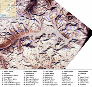
The Baltoro Glacier is a glacier located in the Shigar District of the Gilgit-Baltistan region in Pakistan. It stretches for 63 km (39 mi) in length. It is one of the longest glaciers outside the polar regions. It is home to some of the world’s highest mountains. It runs through the Karakoram mountain range, close to K2, which is the second highest peak in the world, reaching an elevation of 8,611 meters. Within a 20-kilometer radius, there are three more mountains with elevations exceeding 8,000 meters.

<span class="mw-page-title-main">Kunyang Chhish</span> Mountain in India

Kunyang Chhish or Kunyang Chhish is the second-highest mountain in the Hispar Muztagh, a subrange in the Karakoram mountains in Pakistan. An alternate variation of the name is Kunyang Kish. Its height, also sometimes given as 7,823 metres (25,666 ft), is ranked 21st in the world.

<span class="mw-page-title-main">Batura Sar</span> Mountain in Pakistan

Batura Sar, also referred to as Batura I, is the 25th-highest mountain on Earth and the 10th-highest in Pakistan. It is the highest peak of the Batura Muztagh, which is the westernmost subrange of the Karakoram range. It forms the apex of the Batura Wall, a continuously high part of the backbone of the Batura Muztagh.

<span class="mw-page-title-main">Baltoro Muztagh</span> Mountain range in Pakistan/China

The Baltoro Muztagh is a subrange within the Karakoram mountain range. It spans across the Baltistan region of Gilgit-Baltistan, which is the northernmost political entity of Pakistan, and extends into Xinjiang, China. The crest of this range also serves as part of the border between Pakistan and China.

<span class="mw-page-title-main">Rakhiot Peak</span>

Rakhiot Peak is a peak in the Himalayas range of the Gilgit-Baltistan, Pakistan. It is one of the many subsidiary summits of the Nanga Parbat massif.

<span class="mw-page-title-main">Central Karakoram National Park</span> National Park in Pakistan

Central Karakoram National Park is a national park located in Skardu district of Gilgit-Baltistan in Pakistan. It encompasses some of the world’s highest peaks and largest glaciers. Internationally renowned for mountaineering, rock climbing and trekking opportunities, it covers an area of about 10,000 sq. km and contains the greatest concentration of some of the tallest mountains on Earth. It has four peaks over 8,000 m including K2 (8611 m), Gasherbrum-I (8068 m), Gasherbrum-II (8035 m) and Broad Peak (8051 m), and sixty peaks higher than 7,000 m. The park was placed on the World Heritage Site Tentative List in 2016.

<span class="mw-page-title-main">Saltoro Mountains</span> Subrange of the Karakoram located on the southwestern side of the Siachen Glacier in Kashmir

The Saltoro Mountains form a subrange within the Karakoram Range and are situated in the southeastern part of the Karakoram. They lie on the southwest side of the Siachen Glacier, which is one of the two longest glaciers in the world outside the polar regions. The name "Saltoro" is also associated with the Saltoro Valley, located west of this range and descending on the Pakistani side of the Saltoro Range, which generally follows the Actual Ground Position Line (AGPL).

<span class="mw-page-title-main">Gasherbrum V</span> Mountain in Gilgit-Baltistan, Pakistan

Gasherbrum V is a mountain in the Gasherbrum massif, located in the Karakoram range of Gilgit–Baltistan, Pakistan.

<span class="mw-page-title-main">Geography of Gilgit-Baltistan</span>

Gilgit-Baltistan is an administrative territory of Pakistan in the northern part of the country. It was given self-governing status on August 29, 2009. Gilgit-Baltistan comprises 14 districts within three divisions. The four districts of Skardu Kharmang Shigar and Ghanche are in the Baltistan Division, four districts of Gilgit Ghizer Hunza and Nagar districts which were carved out of Gilgit District are in the Gilgit Division and the third division is Diamir, comprising Chilas and Astore. The main political centres are the towns of Gilgit and Skardu.

<span class="mw-page-title-main">Tourism in Gilgit-Baltistan</span> Overview of the tourism industry in Gilgit-Baltistan, Pakistan

Tourism in Gilgit-Baltistan, an administered territory of Pakistan, focuses on its access to various mountain ranges and alpine terrain.

<span class="mw-page-title-main">Kutiah Lungma Glacier</span> Glacier in Pakistan

Kutiah Lungma Glacier is a glacier that stretches for approximately 12 km in length and has a width of about 3 km. It is situated within the Karakoram mountain range in the Stak Valley of District Skardu, Gilgit-Baltistan, Pakistan. This glacier is located in the Stak Valley, which is sometimes referred to as Staq, and it falls within the subdivision of Roundu in district Skardu, Gilgit-Baltistan.

References

  1. "Millions at risk as melting Pakistan glaciers raise flood fears".

Sources