Clinton, Montana

Last updated

Clinton, Montana
Missoula County Montana Incorporated and Unincorporated areas Clinton Highlighted.svg
Location in Missoula County and the state of Montana
Coordinates: 46°46′33″N113°42′54″W / 46.77583°N 113.71500°W / 46.77583; -113.71500
Country United States
State Montana
County Missoula
Area
[1]
  Total3.36 sq mi (8.71 km2)
  Land3.27 sq mi (8.47 km2)
  Water0.09 sq mi (0.24 km2)
Elevation
3,468 ft (1,057 m)
Population
 (2020) [2]
  Total1,018
  Density311.12/sq mi (120.13/km2)
Time zone UTC-7 (Mountain (MST))
  Summer (DST) UTC-6 (MDT)
ZIP code
59825
Area code 406
FIPS code 30-15475
GNIS feature ID0781403

Clinton is an unincorporated community and census-designated place (CDP) in Missoula County, Montana, United States. It is part of the Missoula metropolitan area. The population was 1,018 at the 2020 census. [2]

Contents

Originally established in 1883 as a stage stop and post office with the name "Betters' Station", the town name was changed in 1892 to honor C. L. Clinton, an official of the Northern Pacific Railroad. [3]

Geography

Clinton is located in southeastern Missoula County at 46°46′33″N113°42′54″W / 46.77583°N 113.71500°W / 46.77583; -113.71500 (46.775792, -113.715031). [4] It lies in the valley of the Clark Fork River, which flows northwest 17 miles (27 km) to Missoula, the county seat. Interstate 90 passes through Clinton, with access from Exit 120. I-90 leads northwest to Missoula and southeast 63 miles (101 km) to Deer Lodge.

According to the U.S. Census Bureau, the Clinton CDP has a total area of 3.4 square miles (8.8 km2), of which 0.1 square miles (0.3 km2), or 2.73%, are water. [1] The Clark Fork forms the southwestern edge of the community and is joined from the east by Starvation Creek, Wallace Creek, and Dirty Ike Creek within the bounds of the CDP.

Demographics

Historical population
CensusPop.Note
2000 549
2010 1,05291.6%
2020 1,018−3.2%
U.S. Decennial Census [5]

As of the census [6] of 2010, there were 1,052 people, 204 households, and 153 families residing in the CDP. The population density was 278.6 inhabitants per square mile (107.6/km2). There were 216 housing units at an average density of 109.6 per square mile (42.3/km2). The racial makeup of the CDP was 95.81% White, 0.36% African American, 1.64% Native American, 0.18% Asian, and 2.00% from two or more races. Hispanic or Latino of any race were 0.36% of the population.

There were 204 households, out of which 39.7% had children under the age of 18 living with them, 55.9% were married couples living together, 12.3% had a female householder with no husband present, and 25.0% were non-families. 20.6% of all households were made up of individuals, and 3.4% had someone living alone who was 65 years of age or older. The average household size was 2.69 and the average family size was 3.07.

In the CDP, the population was spread out, with 30.4% under the age of 18, 7.1% from 18 to 24, 33.0% from 25 to 44, 22.4% from 45 to 64, and 7.1% who were 65 years of age or older. The median age was 33 years. For every 100 females, there were 101.8 males. For every 100 females age 18 and over, there were 100.0 males.

The median income for a household in the CDP was $31,731, and the median income for a family was $32,188. Males had a median income of $29,643 versus $22,500 for females. The per capita income for the CDP was $12,510. About 16.0% of families and 19.2% of the population were below the poverty line, including 28.3% of those under age 18 and 20.7% of those age 65 or over.

Education

It is in the Clinton Elementary School District and the Missoula High School District. [7]

See also

Related Research Articles

<span class="mw-page-title-main">Busby, Montana</span> Census-designated place in Big Horn County, Montana, United States

Busby is a census-designated place (CDP) in Big Horn County, Montana, United States. It is on the Northern Cheyenne reservation. The population was 745 at the 2010 census.

<span class="mw-page-title-main">Radersburg, Montana</span> Village in Montana, United States

Radersburg is an unincorporated rural village in Broadwater County, Montana, United States.

<span class="mw-page-title-main">Belfry, Montana</span> Census-designated place in Montana, United States

Belfry is a census-designated place (CDP) in Carbon County, Montana, United States. It is part of the Billings, Montana Metropolitan Statistical Area. The population was 218 at the 2010 census. It is located approximately 11 miles (18 km) from the Wyoming border, roughly halfway between Billings, Montana and Cody, Wyoming.

<span class="mw-page-title-main">North Browning, Montana</span> Census-designated place in Montana, United States

North Browning is a census-designated place (CDP) in Glacier County, Montana, United States. The population was 2,408 at the 2010 census.

<span class="mw-page-title-main">Beaver Creek, Montana</span> Census-designated place in Montana, United States

Beaver Creek is a census-designated place (CDP) in Hill County, Montana, United States. The population was 271 at the 2010 census.

<span class="mw-page-title-main">Augusta, Montana</span> Census-designated place in Montana, United States

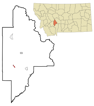
Augusta is an unincorporated community and census-designated place (CDP) in Lewis and Clark County, Montana, United States. The population was 309 at the 2010 census and rose to 316 in the 2020 census. The most accepted version in the naming of this town is after Augusta Hogan, thought to be the first child born in this town, the daughter of J. D. Hogan, an early rancher.

<span class="mw-page-title-main">St. Regis, Montana</span> Census-designated place in Montana, United States

St. Regis or Saint Regis is an unincorporated community and census-designated place (CDP) in Mineral County, Montana. The population was 313 at the time of the 2020 census.

<span class="mw-page-title-main">Bonner-West Riverside, Montana</span> Census-designated place in Montana, United States

Bonner-West Riverside is a census-designated place (CDP) in Missoula County, Montana, United States, including the unincorporated communities of Bonner, Milltown, West Riverside, and Pinegrove. It is part of the Missoula metropolitan area. The population was 1,690 at the 2020 census.

<span class="mw-page-title-main">East Missoula, Montana</span> CDP in Montana, United States

East Missoula is a census-designated place (CDP) in Missoula County, Montana, United States. It is part of the Missoula, Montana Metropolitan Statistical Area'. The population was 2,157 at the 2010 census, an increase from its population of 2,070 in 2000.

<span class="mw-page-title-main">Evaro, Montana</span> CDP in Montana, United States

Evaro is a census-designated place (CDP) in Missoula County, Montana, United States, and part of the Missoula Metropolitan Statistical Area. It is located on the southernmost tip of the Flathead Indian Reservation, approximately 12 miles (19 km) north of downtown Missoula and is served by US Highway 93. In 2010, Evaro had a population of 322, a decrease from 329 in 2000.

<span class="mw-page-title-main">Frenchtown, Montana</span> CDP in Montana, United States

Frenchtown is a census-designated place (CDP) in Missoula County, Montana, United States. It is part of the Missoula, Montana Metropolitan Statistical Area. The population was 1,825 at the 2010 census, an increase from its population of 883 in 2000.

<span class="mw-page-title-main">Lolo, Montana</span> CDP in Montana, United States

Lolo is a census-designated place (CDP) in Missoula County, Montana, United States. It is part of the Missoula Metropolitan Statistical Area. The population was 4,399 at the 2020 census, an increase from its population of 3,892 in 2010. It is home to Travelers' Rest State Park, a site where Lewis and Clark camped in 1805 and again in 1806.

<span class="mw-page-title-main">Orchard Homes, Montana</span> CDP in Montana, United States

Orchard Homes is a census-designated place (CDP) in Missoula County, Montana, United States. It is part of the Missoula Metropolitan Statistical Area. The population was 5,377 at the 2020 census.

<span class="mw-page-title-main">Seeley Lake, Montana</span> CDP in Montana, United States

Seeley Lake is a census-designated place (CDP) in Missoula County, Montana, United States. It is part of the 'Missoula, Montana Metropolitan Statistical Area'. The town sits beside the 1,031.5 acres lake Seeley Lake. The population was 1,682 at the 2020 census.

<span class="mw-page-title-main">Wye, Montana</span> Place in Montana, United States

Wye is an unincorporated community in Missoula County, Montana, United States. It is part of the Missoula, Montana Metropolitan Statistical Area. The population was 511 at the 2010 census, an increase from its population of 381 in 2000. For statistical purposes, the United States Census Bureau has defined Wye as a census-designated place (CDP). Wye is named for the "y"-shaped DeSmet Junction where US 93 and MT 200 met former US 10.

<span class="mw-page-title-main">Avon, Montana</span> CDP in Montana, United States

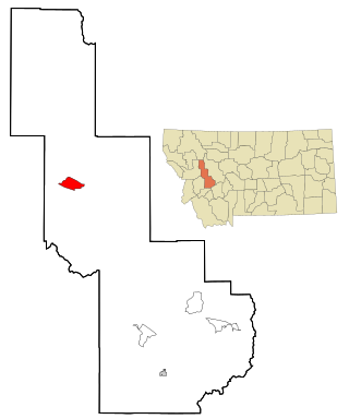
Avon is a census-designated place (CDP) in Powell County, Montana, United States. The population was 124 at the 2000 census. The town sits along the Little Blackfoot River, and serves as a gateway to the Beaverhead-Deerlodge National Forest.

<span class="mw-page-title-main">Ovando, Montana</span> CDP in Montana, United States

Ovando is a census-designated place (CDP) in Powell County, Montana, United States. It is approximately fifty-four miles ENE of Missoula, Montana. The population was 71 at the 2000 census.

<span class="mw-page-title-main">Birney, Montana</span> Census-designated place in Montana, United States

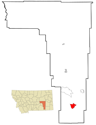
Birney is a census-designated place (CDP) in Rosebud County, Montana, United States. The population was 108 at the 2000 census.

<span class="mw-page-title-main">Antelope, Montana</span> CDP in Montana, United States

Antelope is a census-designated place (CDP) in Sheridan County, Montana, United States. The population was 51 at the 2010 census.

Box Elder is an unincorporated community and census-designated place (CDP) in Hill County in the U.S. state of Montana. The population was 87 at the 2010 census. The population was 794 at the 2000 census, but before 2010 the Box Elder CDP was split into the current much-smaller Box Elder CDP, while most of the former CDP area went into the new Rocky Boy West CDP. Box Elder is the headquarters of the Chippewa-Cree tribe.

References

  1. 1 2 "2023 U.S. Gazetteer Files: Montana". United States Census Bureau. Retrieved May 30, 2024.
  2. 1 2 "P1. Race – Clinton CDP, Montana: 2020 DEC Redistricting Data (PL 94-171)". U.S. Census Bureau. Retrieved May 30, 2024.
  3. "Clinton". Montana Place Names Companion. Montana Historical Society. Retrieved April 2, 2021.
  4. "US Gazetteer files: 2010, 2000, and 1990". United States Census Bureau. February 12, 2011. Retrieved April 23, 2011.
  5. "Census of Population and Housing". Census.gov. Retrieved June 4, 2016.
  6. "U.S. Census website". United States Census Bureau . Retrieved January 31, 2008.
  7. "2020 CENSUS - SCHOOL DISTRICT REFERENCE MAP: Missoula County, MT" (PDF). U.S. Census Bureau . Retrieved March 13, 2024.