Lolo, Montana

Last updated

Lolo, Montana
Lolo montana 01.jpg
Nickname: 
(Salish: čkʷlkʷqin [1] )
Missoula County Montana Incorporated and Unincorporated areas Lolo Highlighted.svg
Location in Missoula County and the state of Montana. Grey shading indicates city of Missoula.
Coordinates: 46°45′55″N114°5′9″W / 46.76528°N 114.08583°W / 46.76528; -114.08583
Country United States
State Montana
County Missoula
Area
[2]
  Total9.63 sq mi (24.95 km2)
  Land9.46 sq mi (24.50 km2)
  Water0.17 sq mi (0.45 km2)
Elevation
3,199 ft (975 m)
Population
 (2020) [3]
  Total4,399
  Density464.96/sq mi (179.52/km2)
Time zone UTC-7 (Mountain (MST))
  Summer (DST) UTC-6 (MDT)
ZIP code
59847
Area code 406
FIPS code 30-44650
GNIS feature ID0786464

Lolo is an unincorporated community and census-designated place (CDP) in Missoula County, Montana, United States. It is part of the Missoula metropolitan area. The population was 4,399 at the 2020 census, [3] an increase from its population of 3,892 in 2010. It is home to Travelers' Rest State Park, a site where Lewis and Clark camped in 1805 and again in 1806.

Contents

History

The Traveler's Rest site, in Lolo, is one of the few sites in the nation with physical confirmation of the visit of Lewis and Clark. [4]

There are several versions of the origin of the town name. One is a French pronunciation of the name Lawrence Rence, a fur trapper in the area. [5] [6] Another is the French name for Meriwether Lewis, "Le Louis". [7] Or it could be based on either a Chinook word or a Nez Perce word. [7] In addition to the town, a national forest, creek, mountain peak, mountain pass, hot springs, and historic trail are all named Lolo. [5]

The 2017 Lolo Peak Fire burned thousands of acres 10 miles (16 km) southwest of Lolo, prompting evacuations and closure of U.S. Route 12. [8]

Geography

Lolo is in south-central Missoula County, at the confluence of Lolo Creek and the Bitterroot River, a north-flowing tributary of the Clark Fork. The Bitterroot Mountains are to the west. The town is at the eastern end of the Lolo Trail, present-day U.S. Route 12, which crosses Lolo Pass at the Idaho state line 33 miles (53 km) west of town. U.S. Route 93 also passes through the community. Missoula is 10 miles (16 km) to the northeast via US 12, while Hamilton is 37 miles (60 km) to the south via US 93.

According to the U.S. Census Bureau, the Lolo CDP has a total area of 9.63 square miles (24.9 km2), of which 9.46 square miles (24.5 km2) are land and 0.17 square miles (0.44 km2), or 1.79%, are water. [2]

Climate

This climatic region is typified by large seasonal temperature differences, with warm to hot (and often humid) summers and cold (sometimes severely cold) winters. According to the Köppen Climate Classification system, Lolo has a humid continental climate, abbreviated "Dfb" on climate maps. [9]

Climate data for Lolo, Montana
MonthJanFebMarAprMayJunJulAugSepOctNovDecYear
Mean daily maximum °C (°F)0
(32)
4
(39)
9
(48)
16
(60)
21
(69)
26
(78)
30
(86)
29
(85)
23
(73)
17
(62)
7
(44)
2
(35)
15
(59)
Mean daily minimum °C (°F)−14
(6)
−12
(11)
−6
(21)
−1
(31)
5
(41)
9
(49)
12
(53)
11
(51)
5
(41)
−1
(30)
−8
(18)
−13
(9)
−1
(30)
Average precipitation mm (inches)15
(0.6)
10
(0.4)
20
(0.8)
28
(1.1)
53
(2.1)
58
(2.3)
36
(1.4)
38
(1.5)
30
(1.2)
18
(0.7)
13
(0.5)
13
(0.5)
330
(13.1)
Source: Weatherbase [10]

Demographics

Historical population
CensusPop.Note
1980 2,418
1990 2,74613.6%
2000 3,38823.4%
2010 3,89214.9%
2020 4,39913.0%
U.S. Decennial Census [11]

As of the census [12] of 2010, there were 3,892 people, 1,218 households, and 936 families residing in the CDP. The population density was 356.2 inhabitants per square mile (137.5/km2). There were 1,263 housing units at an average density of 132.8 per square mile (51.3/km2). The racial makeup of the CDP was 96.69% White, 0.24% African American, 0.89% Native American, 0.24% Asian, 0.21% from other races, and 1.74% from two or more races. Hispanic or Latino of any race were 1.03% of the population.

There were 1,218 households, out of which 44.0% had children under the age of 18 living with them, 61.6% were married couples living together, 10.3% had a female householder with no husband present, and 23.1% were non-families. 17.3% of all households were made up of individuals, and 4.5% had someone living alone who was 65 years of age or older. The average household size was 2.78 and the average family size was 3.15.

In the CDP, the population was spread out, with 31.3% under the age of 18, 8.2% from 18 to 24, 32.9% from 25 to 44, 20.8% from 45 to 64, and 6.8% who were 65 years of age or older. The median age was 32 years. For every 100 females, there were 100.2 males. For every 100 females age 18 and over, there were 96.5 males.

The median income for a household in the CDP was $43,846, and the median income for a family was $46,629. Males had a median income of $30,392 versus $22,188 for females. The per capita income for the CDP was $18,369. About 2.5% of families and 4.7% of the population were below the poverty line, including 5.8% of those under age 18 and 4.2% of those age 65 or over.

Lolo Fire smoke plume from Missoula, August 16, 2017 View of Lolo Fire smoke plume from Missoula on August 16 2017.jpg
Lolo Fire smoke plume from Missoula, August 16, 2017

Education

Most of Lolo is in Lolo Elementary School District while the a small portion is in Missoula Elementary School District and another small portion is in Woodman Elementary School District. All of it is in Missoula High School District. [13]

The Lolo School District has two schools, Lolo Elementary (K-4) and Lolo Middle School (5-8). [14] During the 2021-2022 school year, a total of 538 students were enrolled. [15]

Students attend high school in Missoula.

The Missoula Public Library has a branch location in Lolo. [16]

Media

The FM radio station KDXT is licensed in Lolo. [17] It airs a country music format.

Infrastructure

The town lies at the intersection of U.S. Routes 12 and 93.

Healthcare is provided in Missoula.

Notable people

See also

Related Research Articles

<span class="mw-page-title-main">Ravalli County, Montana</span> County in Montana, United States

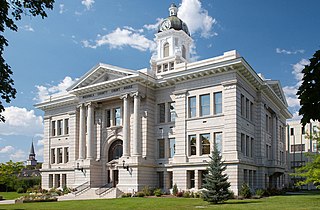
Ravalli County is a county in the southwestern part of the U.S. state of Montana. As of the 2020 census, the population was 44,174. Its county seat is Hamilton.

<span class="mw-page-title-main">Missoula County, Montana</span> County in Montana, United States

Missoula County is a county located in the State of Montana. As of the 2020 census, the population was 117,922, making it Montana's third most populous county. Its county seat and most populous city is Missoula. The county was founded in 1860.

<span class="mw-page-title-main">Flathead County, Montana</span> County in Montana, United States

Flathead County is a county located in the U.S. state of Montana. At the 2020 census, its population was 104,357, making it the state's fourth most populous county. Its county seat is Kalispell. Its numerical designation is 7. Its northern border is on the state's north border, making it contiguous with the Canada–US border, facing British Columbia.

<span class="mw-page-title-main">Busby, Montana</span> Census-designated place in Big Horn County, Montana, United States

Busby is a census-designated place (CDP) in Big Horn County, Montana, United States. It is on the Northern Cheyenne reservation. The population was 745 at the 2010 census.

<span class="mw-page-title-main">Belfry, Montana</span> Census-designated place in Montana, United States

Belfry is a census-designated place (CDP) in Carbon County, Montana, United States. It is part of the Billings, Montana Metropolitan Statistical Area. The population was 218 at the 2010 census. It is located approximately 11 miles (18 km) from the Wyoming border, roughly halfway between Billings, Montana and Cody, Wyoming.

<span class="mw-page-title-main">South Browning, Montana</span> Census-designated place in Montana, United States

South Browning is a census-designated place (CDP) in Glacier County, Montana, United States. The population was 1,785 at the 2010 census. South Browning is a rural village on the Blackfeet Indian Reservation. It is bordered to the north by the town of Browning.

<span class="mw-page-title-main">Charlo, Montana</span> Census-designated place in Montana, United States

Charlo is an unincorporated community and census-designated place (CDP) in Lake County, Montana, United States. The population was 385 at the 2020 census.

<span class="mw-page-title-main">St. Regis, Montana</span> Census-designated place in Montana, United States

St. Regis or Saint Regis is an unincorporated community and census-designated place (CDP) in Mineral County, Montana. The population was 313 at the time of the 2020 census.

<span class="mw-page-title-main">Clinton, Montana</span> Census-designated place in Montana, United States

Clinton is an unincorporated community and census-designated place (CDP) in Missoula County, Montana, United States. It is part of the Missoula metropolitan area. The population was 1,018 at the 2020 census.

<span class="mw-page-title-main">East Missoula, Montana</span> Census-designated place in Montana, United States

East Missoula is an unincorporated community and census-designated place (CDP) in Missoula County, Montana, United States. It is part of the Missoula metropolitan area. The population was 2,465 at the 2020 census, up from 2,157 in 2010.

<span class="mw-page-title-main">Evaro, Montana</span> Census-designated place in Montana, United States

Evaro is a census-designated place (CDP) in Missoula County, Montana, United States, and part of the Missoula metropolitan area. It is located on the southernmost part of the Flathead Indian Reservation, approximately 20 miles (32 km) north of downtown Missoula via US Highway 93. As of the 2020 census, the population of the CDP was 373, up from 322 in 2010.

<span class="mw-page-title-main">Frenchtown, Montana</span> Census-designated place in Montana, United States

Frenchtown is an unincorporated community and census-designated place (CDP) in Missoula County, Montana, United States. It is part of the Missoula metropolitan area. The population was 1,958 as of the 2020 census.

<span class="mw-page-title-main">Orchard Homes, Montana</span> Census-designated place in Montana, United States

Orchard Homes is a census-designated place (CDP) in Missoula County, Montana, United States. It is part of the Missoula metropolitan area. The population was 5,377 at the 2020 census.

<span class="mw-page-title-main">Seeley Lake, Montana</span> CDP in Montana, United States

Seeley Lake is a census-designated place (CDP) in Missoula County, Montana, United States. It is part of the 'Missoula, Montana Metropolitan Statistical Area'. The town sits beside the 1,031.5 acres lake Seeley Lake. The population was 1,682 at the 2020 census.

<span class="mw-page-title-main">Wye, Montana</span> Place in Montana, United States

Wye is an unincorporated community in Missoula County, Montana, United States. It is part of the Missoula, Montana Metropolitan Statistical Area. The population was 511 at the 2010 census, an increase from its population of 381 in 2000. For statistical purposes, the United States Census Bureau has defined Wye as a census-designated place (CDP). Wye is named for the "y"-shaped DeSmet Junction where US 93 and MT 200 met former US 10.

<span class="mw-page-title-main">Darby, Montana</span> Town in Montana, United States

Darby is a town in Ravalli County, Montana, United States. The population was 783 at the 2020 census. Darby is located near the southwestern border of Montana and Idaho, along the Continental Divide.

<span class="mw-page-title-main">Florence, Montana</span> Census-designated place in Montana, United States

Florence is a census-designated place (CDP) in Ravalli County, Montana. County Line Rd is on the northern edge of the city limits dividing it from Missoula County, Montana. The population was 821 at the 2020 census.

<span class="mw-page-title-main">Victor, Montana</span> Census-designated place in Montana, United States

Victor is a census-designated place (CDP) in Ravalli County, Montana, United States. The population was 789 at the 2020 Census, compared to 745 at the 2010 census.

<span class="mw-page-title-main">Shepherd, Montana</span> CDP in Montana, United States

Shepherd is a census-designated place (CDP) in Yellowstone County, Montana, United States. The population was 193 at the 2000 census. Shepherd is a Billings suburb located to the northeast. The unincorporated town was named after R.E. Shepherd, a prominent early settler and owner of the Billings Land and Irrigation Company and the Merchants National Bank. The post office opened in 1915.

<span class="mw-page-title-main">Arlee, Montana</span> Census-designated place in Montana, United States

Arlee is an unincorporated community and census-designated place (CDP) on the Flathead Reservation, Lake County, Montana, United States. The population was 725 at the 2020 census. It is named after Alee, a Salish chief. The chief's name has no "r", as the Salish alphabet has no letter "r".

References

  1. Nkwusm (2006), Intro to the Salish Language C, Series 1 Part 2, archived from the original on February 1, 2013, retrieved May 3, 2013
  2. 1 2 "2023 U.S. Gazetteer Files: Montana". United States Census Bureau. Retrieved June 5, 2024.
  3. 1 2 "P1. Race – Lolo CDP, Montana: 2020 DEC Redistricting Data (PL 94-171)". U.S. Census Bureau. Retrieved June 5, 2024.
  4. "Travelers' Rest State Park". Travelers' Rest Preservation & Heritage Association. Retrieved October 9, 2018.
  5. 1 2 "Origin of the Name "Lolo"". USDA Forest Service. Retrieved October 20, 2023.
  6. "Fur trapper honored at long-lost gravesite". Missoulian. Retrieved October 20, 2023.
  7. 1 2 "Lolo". Montana Place Names from Alzada to Zortman. Retrieved October 20, 2023.
  8. "Lolo Peak Fire". InciWeb Incident Information system. Retrieved August 20, 2017.
  9. Climate Summary for Lolo, Montana
  10. "Weatherbase.com". Weatherbase. 2013. Retrieved on November 2, 2013.
  11. "Census of Population and Housing". Census.gov. Retrieved June 4, 2016.
  12. "U.S. Census website". United States Census Bureau . Retrieved January 31, 2008.
  13. "2020 CENSUS - SCHOOL DISTRICT REFERENCE MAP: Missoula County, MT" (PDF). U.S. Census Bureau . Retrieved March 13, 2024.
  14. "About Lolo School District". Lolo School District 7. Retrieved October 20, 2023.
  15. "Lolo Elem". National Center for Education Statistics. Retrieved October 20, 2023.
  16. "Hours & Locations". Missoula Public Library. Retrieved April 13, 2021.
  17. "KDXT". FCC. Retrieved October 20, 2023.