Coalport, Pennsylvania

Last updated
Coalport, Pennsylvania
Main from Spruce in Coalport.jpg
Main Street south of Spruce
Clearfield County Pennsylvania Incorporated and Unincorporated areas Coalport Highlighted.svg
Location of Coalport in Clearfield County, Pennsylvania.
Map of Pennsylvania highlighting Clearfield County.svg
Map showing Clearfield County in Pennsylvania
USA Pennsylvania location map.svg
Red pog.svg
Coalport
Location in Pennsylvania
Coordinates: 40°44′53″N78°32′04″W / 40.74806°N 78.53444°W / 40.74806; -78.53444 Coordinates: 40°44′53″N78°32′04″W / 40.74806°N 78.53444°W / 40.74806; -78.53444
Country United States
State Pennsylvania
County Clearfield
Settled1876
Incorporated1883
Government
  TypeBorough Council
Area
[1]
  Total0.38 sq mi (0.98 km2)
  Land0.37 sq mi (0.97 km2)
  Water0.01 sq mi (0.01 km2)
Elevation
1,382 ft (421 m)
Population
 (2020) [2]
  Total425
  Density1,136.36/sq mi (438.67/km2)
Time zone UTC-5 (Eastern (EST))
  Summer (DST) UTC-4 (EDT)
ZIP code
16627
Area code 814
FIPS code 42-14656

Coalport is a borough in Clearfield County, Pennsylvania, United States. The population was 425 at the 2020 census. [3]

Contents

Geography

Coalport is located in southern Clearfield County at 40°44′53″N78°32′04″W / 40.748040°N 78.534322°W / 40.748040; -78.534322 , [4] on the east side of Clearfield Creek, a north-flowing tributary of the West Branch Susquehanna River. Pennsylvania Route 53 passes through the borough, leading north 2 miles (3 km) to Irvona and south 2 miles (3 km) to Flinton in Cambria County.

According to the United States Census Bureau, Coalport has a total area of 0.38 square miles (0.98 km2), of which 0.004 square miles (0.01 km2), or 1.45%, is water. [5]

Demographics

Historical population
CensusPop.
1890 855
1900 9389.7%
1910 876−6.6%
1920 1,07923.2%
1930 1,22213.3%
1940 1,121−8.3%
1950 1,052−6.2%
1960 821−22.0%
1970 796−3.0%
1980 739−7.2%
1990 578−21.8%
2000 490−15.2%
2010 5236.7%
2020 425−18.7%
2021 (est.)426 [3] 0.2%
Sources: [6] [7] [8] [9] [2]

As of the census [7] of 2000, there were 490 people, 223 households, and 132 families residing in the borough. The population density was 1,273.9 people per square mile (497.9/km2). There were 260 housing units at an average density of 675.9 per square mile (264.2/km2). The racial makeup of the borough was 98.57% White, 1.02% Asian, 0.20% from other races, and 0.20% from two or more races. Hispanic or Latino of any race were 0.20% of the population.

There were 223 households, out of which 21.1% had children under the age of 18 living with them, 45.7% were married couples living together, 9.0% had a female householder with no husband present, and 40.8% were non-families. 36.8% of all households were made up of individuals, and 15.7% had someone living alone who was 65 years of age or older. The average household size was 2.20 and the average family size was 2.89.

In the borough the population was spread out, with 19.0% under the age of 18, 9.4% from 18 to 24, 27.6% from 25 to 44, 25.3% from 45 to 64, and 18.8% who were 65 years of age or older. The median age was 42 years. For every 100 females there were 92.2 males. For every 100 females age 18 and over, there were 93.7 males.

The median income for a household in the borough was $26,528, and the median income for a family was $40,833. Males had a median income of $28,438 versus $20,313 for females. The per capita income for the borough was $16,232. About 12.1% of families and 15.6% of the population were below the poverty line, including 24.6% of those under age 18 and 9.6% of those age 65 or over.

Related Research Articles

<span class="mw-page-title-main">Ashville, Pennsylvania</span> Borough in Pennsylvania, United States

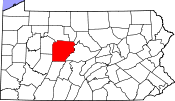
Ashville is a borough in Cambria County, Pennsylvania, United States. It is part of the Johnstown, Pennsylvania Metropolitan Statistical Area. However, it is much closer to Altoona and is often considered a suburb of the latter. The population was 213 at the 2020 census.

<span class="mw-page-title-main">Clearfield Township, Cambria County, Pennsylvania</span> Township in Pennsylvania, United States

Clearfield Township is a township in Cambria County, Pennsylvania, United States. The population was 1,608 at the 2020 census. It is part of the Johnstown, Pennsylvania Metropolitan Statistical Area.

<span class="mw-page-title-main">Dean Township, Cambria County, Pennsylvania</span> Township in Pennsylvania, United States

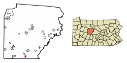
Dean Township is a township in Cambria County, Pennsylvania, United States. The population was 391 at the 2010 census. It is part of the Johnstown, Pennsylvania Metropolitan Statistical Area.

<span class="mw-page-title-main">Beccaria Township, Clearfield County, Pennsylvania</span> Township in Pennsylvania, United States

Beccaria Township is a township in Clearfield County, Pennsylvania, United States. The population was 1,769 at the 2020 census. It is named in honor of Cesare Beccaria, an Enlightenment thinker.

<span class="mw-page-title-main">Brisbin, Pennsylvania</span> Borough in Pennsylvania, United States

Brisbin is a borough in Clearfield County, Pennsylvania, United States. The population was 422 at the 2020 census.

<span class="mw-page-title-main">Burnside, Pennsylvania</span> Borough in Pennsylvania, United States

Burnside is a borough in Clearfield County, Pennsylvania, United States. The population was 188 at the 2020 census.

<span class="mw-page-title-main">Curwensville, Pennsylvania</span> Borough in Pennsylvania, United States

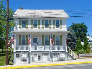
Curwensville is a borough in Clearfield County, Pennsylvania, United States, 45 miles (72 km) north of Altoona on the West Branch Susquehanna River. Coal mining, tanning, and the manufacture of fire bricks were the industries at the turn of the 20th century. In 1900, 1,937 people lived in the borough, and in 1910, 2,549 lived there. As of the 2020 U.S. census, the borough had a population of 2,567. The population of the borough at its highest was 3,422 in 1940.

<span class="mw-page-title-main">Glen Hope, Pennsylvania</span> Borough in Pennsylvania, United States

Glen Hope is a borough in Clearfield County, Pennsylvania, United States. The population was 125 at the 2020 census.

<span class="mw-page-title-main">Grampian, Pennsylvania</span> Borough in Pennsylvania, United States

Grampian is a borough in Clearfield County, Pennsylvania, United States. The population was 358 as of the 2020 census.

<span class="mw-page-title-main">Irvona, Pennsylvania</span> Borough in Pennsylvania, United States

Irvona is a borough in Clearfield County, Pennsylvania, United States. The population was 550 at the 2020 census.

<span class="mw-page-title-main">Lawrence Township, Clearfield County, Pennsylvania</span> Township in Pennsylvania, United States

Lawrence Township is a township in Clearfield County, Pennsylvania, United States. The population was 7,503 at the 2020 census. Lawrence Township borders the townships of Boggs, Bradford, Goshen, Huston, Knox, Pike and Pine in Clearfield County, as well as Benezette and Jay Townships in Elk County to the north. Lawrence Township borders the borough of Clearfield as well.

<span class="mw-page-title-main">Mahaffey, Pennsylvania</span> Borough in Pennsylvania, United States

Mahaffey is a borough in Clearfield County, Pennsylvania, United States. The population was 325 at the 2020 census.

<span class="mw-page-title-main">New Washington, Pennsylvania</span> Borough in Pennsylvania, United States

New Washington is a borough in Clearfield County, Pennsylvania, United States. The population was 52 at the 2020 census.

<span class="mw-page-title-main">Newburg, Clearfield County, Pennsylvania</span> Borough in Pennsylvania, United States

Newburg is a borough in Clearfield County, Pennsylvania, United States. The population was 79 at the 2020 census.

<span class="mw-page-title-main">Osceola Mills, Pennsylvania</span> Borough in Pennsylvania, United States

Osceola Mills is a borough in Clearfield County, Pennsylvania, United States. The population was 1,044 at the 2020 census.

<span class="mw-page-title-main">Ramey, Pennsylvania</span> Borough in Pennsylvania, United States

Ramey is a borough in Clearfield County, Pennsylvania, United States. The population was 434 at the 2020 census.

<span class="mw-page-title-main">Troutville, Pennsylvania</span> Borough in Pennsylvania, United States

Troutville is a borough in Clearfield County, Pennsylvania, United States. The population was 230 at the 2020 census.

<span class="mw-page-title-main">Wallaceton, Pennsylvania</span> Borough in Pennsylvania, United States

Wallaceton is a borough in Clearfield County, Pennsylvania, United States. The population was 299 at the 2020 census.

<span class="mw-page-title-main">Westover, Pennsylvania</span> Borough in Pennsylvania, United States

Westover is a borough in Clearfield County, Pennsylvania, United States. The population was 359 at the 2020 census.

<span class="mw-page-title-main">Falls Creek, Pennsylvania</span> Borough in Pennsylvania, United States

Falls Creek is a borough located in Jefferson and Clearfield counties in Pennsylvania, United States. The population was 1,036 at the 2020 census. Of this, 994 were in Jefferson County, and 42 were in Clearfield County.

References

  1. "ArcGIS REST Services Directory". United States Census Bureau. Retrieved October 12, 2022.
  2. 1 2 "Census Population API". United States Census Bureau. Retrieved Oct 12, 2022.
  3. 1 2 Bureau, US Census. "City and Town Population Totals: 2020—2021". Census.gov. US Census Bureau. Retrieved August 7, 2022.
  4. "US Gazetteer files: 2010, 2000, and 1990". United States Census Bureau. 2011-02-12. Retrieved 2011-04-23.
  5. "Geographic Identifiers: 2010 Census Summary File 1 (G001): Coalport borough, Pennsylvania". U.S. Census Bureau, American Factfinder. Archived from the original on May 1, 2015. Retrieved April 30, 2015.
  6. "Census of Population and Housing". U.S. Census Bureau. Retrieved 11 December 2013.
  7. 1 2 "U.S. Census website". United States Census Bureau . Retrieved 2008-01-31.
  8. "Incorporated Places and Minor Civil Divisions Datasets: Subcounty Resident Population Estimates: April 1, 2010 to July 1, 2012". Population Estimates. U.S. Census Bureau. Archived from the original on 11 June 2013. Retrieved 11 December 2013.
  9. "Census of Population and Housing". Census.gov. Retrieved June 4, 2016.